
Stratigraphy Evidence of Episodic Fluvial Activity in the South Melas
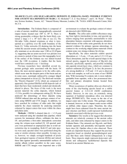
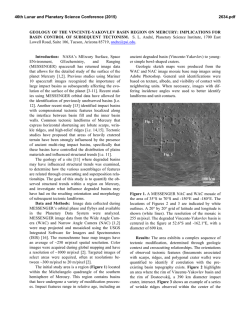
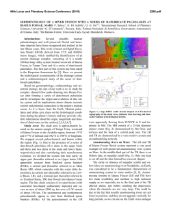
46th Lunar and Planetary Science Conference (2015)
1932.pdf
STRATIGRAPHIC EVIDENCE OF EPISODIC FLUVIAL ACTIVITY IN THE SOUTH MELAS CHASMA
BASIN, VALLES MARINERIS, MARS J. Davis1, 2, P. Grindrod2, 3, R. Williams4, S. Gupta5, and M. Balme6.
1
Dept. of Earth Sciences, University College London, London, UK; [email protected], 2Centre for Planetary
Sciences at UCL-Birkbeck, University College London, London, UK, 3Dept. of Geology and Planetary Science,
Birkbeck, London, UK, 4Planetary Science Institute, Tucson, AZ, USA, 5Dept. of Earth Science and Engineering,
Imperial College, London, UK, 6Dept. of Physical Sciences, The Open University, Milton Keynes, UK.
Introduction: The South Melas basin is an enclosed topographic depression hanging on the southern
wall of Melas Chasma, Valles Marineris. It is widely
recognised to have been host to past aqueous activity
[1, 2]. Central to this interpretation is what appears to
be evidence of a palaeolake that is approximately 45 by
25 kilometres in size in the eastern half of the basin.
The South Melas basin contains a complex stratigraphy, which includes a series of sedimentary fans located on both the east and west side of the basin that
originate from a network of valleys. Previous work has
suggested that both the fans and the valley networks
had an aqueous origin [1, 2]. It was recently proposed
that the basin could have undergone multiple aqueous
events throughout its history [3]. Our work builds on
this interpretation by examining the stratigraphy within
the basin at high resolution and characterising the valleys network to the east.
Methods: The South Melas Basin has exceptional
image coverage in both CTX and HiRISE due to its
candidacy as a landing site for MER, MSL and Mars
2020 [4]. These data were used to map the stratigraphic
succession and the extent of the eastern channel networks at a greater resolution than previous work. Stereo pairs were also used to produce digital elevation
models (DEMs) according to the method of [5] at a
resolution of 20 m/pix for CTX and 1 m/pix for
HiRISE. In total, we used 10 CTX and 18 HiRISE
DEMs to determine stratigraphic relationships and
make structural measurements within the basin.
Results and Discussion:
Basin and Stratigraphic Succession. We mapped
the basin-fill succession layer by layer at HiRISE resolution to characterise variation in facies. The frequent
variation in sediment texture throughout the sequence,
from smooth and flat to rough, polygonalised and mottled, at both the western and eastern edges of the basin
suggests that many further fan deposits are mixed in
with the lacustrine sediment. This trend is particularly
clear in the lower half of the sequence; less so in the
upper half. Additionally, several fan-limb and lobeshaped mounds have been found at the basin floor that
may be the remnants of larger, more extensive fan deposits that are more resistant to erosion.
Midway up the sequence, there is a noticeable
change in the dip direction of the lacustrine stratigra-
phy (Figure 1). This could be an angular unconformity,
representing a break in lacustrine deposition and a drying-out of the basin, during which subsidence and/or
erosion of the sediment may have occurred. Stratigraphically, the aqueous fans on the eastern margin of
the basin lie on deposits above the unconformity,
whereas the aqueous fans on the western margin lie
below it.
Figure 1: Dip direction at the bottom of the image is to the
NE (down sequence); dip direction at the top of the image
(up sequence) is S-SE.
Evidence for a break in deposition is supported by
the occurrence of an exhumed palaeo-dune covered
layered, identified by [3] at a similar stratigraphic position within the succession, which has been interpreted
as an ancient aeolian dune field. This indicates subaerial exposure, presumably caused by the desiccation
of the lake.
Eastern Valley Networks. Previous work at MOC
and THEMIS resolutions found the valley networks to
the east of the palaeolake to be poorly integrated systems with low drainage densities [1]. These valley networks are in contrast to those to the west of the palaeolake, which are fourth to fifth order systems, consistent
with surface runoff and precipitation, and more representative of a poly-phase fluvial system (i.e. they comprise of long, (i.e. they comprise of long, broad and
shallow channels that then have been incised by more
narrow and deep channels).
46th Lunar and Planetary Science Conference (2015)
1932.pdf
Figure 2: Channel map of eastern valley networks. Channels are marked by red lines; channels which contain bright-toned
deposits or show inverted characteristics are marked in yellow. The black line shows the inferred palaeolake boundary. Arrows show flow direction, divided by the watersheds (green).
We have produced a new channel map (Figure 2) at
HiRISE and CTX resolution that shows the eastern
valley networks to be more developed than previous
work suggests. The valley networks and channels are
fourth to fifth order systems, have high drainage densities, and show well defined drainage divides. Although
the eastern valley networks are not as well preserved as
the western valley networks, they show many of the
same characteristics, which have been used to infer
poly-phase fluvial activity in the western networks [3].
Figure 3: Bright-toned deposits left by the narrow
channels. The deposits on the right show inverted
characteristics.
Furthermore, the narrow and deep channels in the
east are surrounded by bright-toned material, similar to
deposits on the western channels. In some cases, this
material makes up the bulk of the channel itself, and
appears to show tendencies towards inversion (Figure
3). Channel inversion means that differential erosion
has exposed the channels as inverted relief. Further
downstream, some channels have deposited similar
material on the canyon wall rock. Our map also shows
that some of the eastern channels can be correlated to
specific fan deposits at the eastern edge of the palaeolake. The bright deposits are also found in these channels, suggesting that the fan may have formed in one of
the later fluvial phases in the basin.
Summary: The reflection in the shift in channel
characteristics on either side of the basin indicates that
water may have been flowing concurrently into the
palaeolake from both the east and the west. If this were
the case, any localised precipitation that could be responsible for the surface water would be across the
entire ~ 300 km2 area. Williams and Weitz [3] estimated a formation time of 102-105 years for the delta and
submarine fans structures in the eastern and western
parts of the basin. An unconformity lying between
these two groups of fans could mean that there were at
least two periods of sustained fluvial flow into the palaeolake.
References: [1] Quantin et al., 2005, JGR 110
E12S19; [2] Metz et al., 2009, JGR 114 E10002; [3]
Williams and Weitz, 2014, Icarus 242 19-37; [4] Williams et al., 2014, Mars 2020 Landing Site Workshop,
Crystal City, VA; [5] Kirk et al., 2008, JGR 113
E00A24.


© Copyright 2026