
A Geologic Map of the Caloris Basin, Mercury - USRA
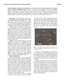
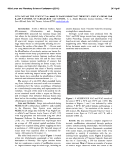
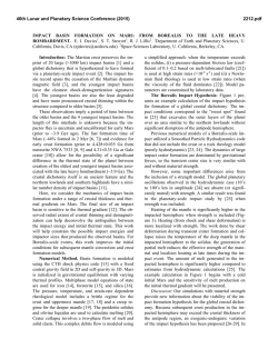
46th Lunar and Planetary Science Conference (2015)
2287.pdf
A GEOLOGIC MAP OF THE CALORIS BASIN, MERCURY. D. L. Buczkowski1 , B. W. Denevi1, C. M.
Ernst1, C. I. Fasset2 and P. K. Byrne3, 1JHU/APL, Laurel, MD 20723, [email protected]; 2Mt. Holyoke
College, S. Hadley, MA; 3LPI, Houston, TX.
Summary: We present our in-progress 1:5M geologic map of the Caloris basin. This map will refine the
stratigraphy of the Caloris basin geologic units and will
include a crater classification scheme based on geomorphology and infilling.
Introduction: The 1,550 km-diameter Caloris basin, the largest impact structure on Mercury, is a highly
complex geologic landform. The basin is floored by
light-toned plains [1] that have been determined to be
volcanic in nature, and multiple landforms, including
volcanic vents and even a possible small shield volcano
[e.g. 2,3], have been identified. The basin floor also
shows a degree of tectonic diversity that is far greater
and more complex than anywhere else on the planet
[4]. Also, the nature of the annulus of dark-toned material that surrounds the basin remains unclear [3]. While
the hummocks are thought to be ejecta blocks, the
smooth, dark, ridged plains interfingering them have
been interpreted to be younger than the light-toned
plains within the Caloris basin. This would imply a
second, plains emplacement event, possibly involving
lower albedo volcanic material, which resurfaced the
original ejecta deposit. A geologic map of the Caloris
basin will serve to synthesize the results of these previous studies into a contextual framework for quickly
viewing the thematic research that has been performed
on this interesting region.
Caloris basin map: In the mapping scheme designed for Mercury, the Caloris basin crosses four
quadrangles: H-3 Shakespeare (21º-66°N, 90º-180°W),
H-4 Raditladi (21º-66°N, 180º-270°W), H-8 Tolstoj
(21ºS -21°N, 144º-216°W) and H-9 Eminescu (21ºS21°N, 216°-288º W). In this mapping effort, we are
developing a Caloris basin map that ranges from 0º60°N, 160º-240°W (Fig. 1), covering both the entire
basin and its surrounding dark annulus, . This areal
extent best summarizes the thematic research of the
Caloris basin region. Such region specific maps are
common on Mars (e.g. the northern plains [5], the
Chryse basin [6], etc.) and can truly focus understanding of a region of interest. We will combining existing
high-resolution maps, crater counts, and stratigraphic
analyses into a single ArcGIS product to be submitted
to the USGS for publication as a finished USGS map.
Geologic Units: Two Mercury quadrangle maps
based on Mariner 10 data cover the eastern third of the
Caloris basin (Fig. 2): H-8 Tolstoj [7] and H-3 Shakespeare [8]. Several terrain units associated with the
Caloris basin were identified by [9]. Later, a rockstratigraphic group consisting of several formations
was developed during the 1:5M mapping of the H-8
Tolstoj [7] and H-3 Shakespeare [8] quadrangles and
then formalized by McCauley et al. [10]. The formations of the Caloris group correspond with the morphological units recognized previously [9] (Fig. 2).
Figure 1. Spatial extent of mapping area. Geomorphic
map of [20] also shown.
Figure 2. MESSENGER mosaic of the Caloris basin
overlain by portions of the H-8 Tolstoj [7] and H-3
Shakespeare [8] quadrangles. Odin Formation is
light blue; Smooth Plains are pink.
The most prominent annular feature surrounding
the Caloris basin structure is comprised of smoothsurfaced massifs 1-2 km high and 100-150 km wide.
Originally referred to as “mountain terrain” [9], the
unit was officially named the Caloris Montes Formation (cm) [7,8,10]. The component blocks were interpreted as uplifted bedrock [9].
46th Lunar and Planetary Science Conference (2015)
The depressions between the massifs of the Caloris
Montes are mantled by a undulating to smooth unit
called the Nevro Formation (cn) [7,8,10]. McCauley et
al. [10] interpreted these “intermontane plains” [9] as
fallback material from the Caloris impact itself, but
much of the formation may be impact melt ejected
from the excavation cavity of the basin [11].
There are two units considered to be facies of
Caloris ejecta [7-10]. Hummocky plains [9], consisting
of low hills ranging from 0.3-1 km across and up to a
few hundred meters high, encircle the basin in a broad
annulus that extends up to many hundreds of kilometers from the Caloris Montes. This unit is formally
named the Odin Formation (co) [7,8,10]. In some places the Odin hills are concentric to the rim of the Caloris
basin, and the spacing between hills can vary greatly.
The outer boundary of the Odin Formation is gradational with the younger Smooth Plains Material (ps)
exterior to the Caloris basin, which is similarly surrounded by the older, pre-Caloris Intercrater Plains
Material (pi).
The Van Eyck Formation (cvl) includes a lineated
terrain extending radially 1000 km from the outer edge
of the Caloris Montes and clusters of secondary craters
identified by [7]. The long, hilly ridges and grooves
comprising the Van Eyck are sub-radial to the basin
proper and are interpreted as ejecta from Caloris secondaries.
An extensive plains unit, similar in appearance to
the ps material outside of Caloris, covers the floor of
the basin. However, the Caloris floor material shows
more intense tectonic deformation than the exterior
smooth plains, including abundant wrinkle ridges and
graben with discrete basin-radial, -concentric, and oblique orientations [4]. In the Tolstoj and Shakespeare quadrangles the Caloris Floor Plains Material
(cfp) and the Smooth Plains Material (ps) are mapped
as distinct units [7,8]. Unable to discern an unequivocal formation mechanism for the cfp material, the
quadrangle maps suggest that it is either volcanic in
origin or a thick impact-melt sheet.
Discussion: There are two geologic units considered to be facies of Caloris ejecta: the Odin formation
and the Van Eyck formation [7-10]. However, Fassett
et al. [12] concluded that while the Odin Formation
knobs are Caloris ejecta blocks, they may have been
mostly embayed and buried by younger volcanic deposits. Conversely, Denevi et al. [3] found conflicting
evidence for the origin of the circum-Caloris plains,
and determined that the crater size–frequency distributions in these regions may not be meaningful discrimi-
2287.pdf
nators of age. They suggested that the higher density of
craters on the Caloris rim and ejecta deposits may be
the result of non-uniform self-secondary cratering, such
as has sometimes been observed on the Moon [13-16].
A second possibility is that a difference in target material properties between ejecta deposits and impact melt
could also have resulted in a higher density of craters
on the Caloris rim, leading to a false interpretation of
greater age. This, too, has been observed in lunar craters [16-19]. Meanwhile, Buczkowski et al. [20] found
that the Odin Formation showed two distinct sub-units:
a dark sub-unit that has a higher concentration of knobs
and a (relatively) bright sub-unit that has fewer and
fresher craters (Fig. 2). They suggested that the bright
sub-unit represents a volcanic flow younger than and
interfingering the knobs and darker flows that represent
the Caloris ejecta. By integrating all current data sets,
analyses, and maps into a single map product, the persisting question of the nature of the Odin formation can
be addressed definitively.
Acknowledgements: This work is supported by the
Planetary Geology and Geophysics program, grant
number NNX14AP50G.
References: [1] Murchie S. et al. (2008) Science,
185, 73-76. [2] Goudge T. A. et al. (2012) LPS XLIII,
Abstract #1325. [3] Denevi B. W. et al. (2013) JGR,
118, doi:10.1002/jgre.20075. [4] Byrne P. K. et al.
(2014) Nature Geosci., 7, 301–307. [5] Tanaka K. L. et
al. (2005) U.S. Geol. Survey Map I-2888. [6] Rotto S.
and Tanaka K. L. (1995) U.S. Geol. Survey Map I2441. [7] Schaber G. G. and McCauley J. F. (1980)
U.S. Geol. Survey, Map I-1199. [8] Guest J. E. and
Greeley R. (1983) U.S. Geol. Survey, Map I-1408. [9]
Trask N. J. and Guest J. E. (1975) JGR., 80, 24622477. [10] McCauley J. F. et al. (1981) Icarus, 47,
184-202. [11] Spudis P. D. and Guest J. E. (1988) in
Mercury, Univ. of Ariz. Press, 118-164. [12] Fassett C.
I. et al. (2009) EPSL, 285, 297-308. [13] Shoemaker E.
M. et al. (1968) in Surveyor 7 Mission Report. Part 2.
NASA Tech. Rep., 32-700, 75–134. [14] Plescia J. B. et
al. (2010), LPS XLI, Abstract #2038. [15] Plescia J. B.
and Robinson M. S. (2011), LPS XLII, Abstract #1839.
[16] Hiesinger H. et al. (2012) JGR, 117, doi:
10.1029/2011JE00393. [17] Schultz P. H. et al. (1977)
LPS VIII, 3539–3564. [18] Dundas C. M. et al. (2010)
GRL, 37, doi: 10.1029/ 2010GL042869. [19] van der
Bogert, C. H. et al. (2010) LPS XLI, Abstract #2165.
[20] Buczkowski D. L. and Seelos K. D. (2012) LPS
XLIII, Abstract #1844.

© Copyright 2026