
Geology of the Vincente-Yakovlev Basin Region on Mercury
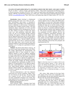
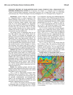
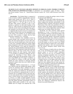
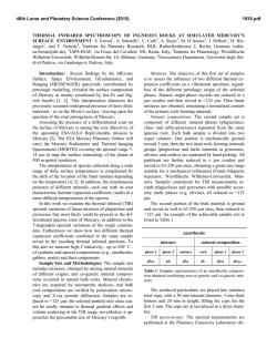
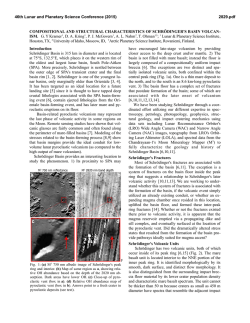
46th Lunar and Planetary Science Conference (2015)
2634.pdf
GEOLOGY OF THE VINCENTE-YAKOVLEV BASIN REGION ON MERCURY: IMPLICATIONS FOR
BASIN CONTROL OF SUBSEQUENT TECTONISM. S. L. André, Planetary Science Institute, 1700 East
Lowell Road, Suite 106, Tucson, Arizona 85719, [email protected].
Introduction: NASA’s MErcury Surface, Space
ENvironment,
GEochemistry,
and
Ranging
(MESSENGER) spacecraft has returned image data
that allows for the detailed study of the surface of the
planet Mercury [1,2]. Previous studies using Mariner
10 spacecraft images recognized the importance of
large impact basins as subsequently affecting the evolution of the surface of the planet [3-11]. Recent studies using MESSENGER orbital data have allowed for
the identification of previously unobserved basins [i.e.
12]. Another recent study [13] identified impact basins
with compressional tectonic features localized along
the interface between basin fill and the inner basin
walls. Common tectonic landforms of Mercury that
express horizontal shortening are lobate scarps, wrinkle ridges, and high-relief ridges [i.e. 14,15]. Tectonic
studies have proposed that areas of heavily cratered
terrain have been strongly influenced by the presence
of ancient multi-ring impact basins, specifically that
these basins have controlled the distribution of plains
materials and influenced structural trends [i.e. 11].
The geology of a site [11] where degraded basins
may have influenced structural trends was examined,
to determine how the various assemblages of features
are related through crosscutting and superposition relationships. The goal of this study is to quantify the observed structural trends within a region on Mercury,
and investigate what influence degraded basins may
have had on the resulting orientation and morphology
of subsequent tectonic landforms.
Data and Methods: Image data collected during
MESSENGER’s orbital phase and flybys and available
in the Planetary Data System were analyzed.
MESSENGER image data from the Wide Angle Camera (WAC) and Narrow Angle Camera (NAC) [1,2]
were map projected and mosaicked using the USGS
Integrated Software for Imagers and Spectrometers
(ISIS) [16]. The monochrome base map images have
an average of ~250 m/pixel spatial resolution. Color
images were acquired during global mapping and have
a resolution of ~1000 m/pixel [2]. Targeted images of
select areas were acquired, often at resolutions between ~300 m/pixel to 20 m/pixel [2].
The initial study area is a region (Figure 1) located
within the Michelangelo quadrangle of the southern
hemisphere of Mercury. This region contains basins
that have undergone a variety of modification processes. Impact features range in relative age, including an
ancient degraded basin (Vincente-Yakovlev) to younger simple bowl-shaped craters.
Geologic sketch maps were produced from the
WAC and NAC image mosaic base map images using
Adobe Photoshop. General unit identifications were
based on texture, albedo, and visibility of contact with
neighboring units. When necessary, images with differing incidence angles were used to better identify
landforms and unit contacts.
Figure 1. A MESSENGER NAC and WAC mosaic of
the area of 35°S to 70°S and -150°E and -180°E. The
locations of Figures 2 and 3 are indicated by white
outlines. A 20° by 20° grid of latitude and longitude is
shown (white lines). The resolution of the mosaic is
255 m/pixel. The degraded Vincente-Yakovlev basin is
centered in the figure at 52.6°S and -162.1°E, with a
diameter of 690 km.
Results: The area exhibits a complex sequence of
tectonic modification, determined through geologic
context and crosscutting relationships. The orientations
of observed tectonic features (lineaments associated
with scarps, ridges, and polygonal crater walls) were
quantified to identify if correlation with the preexisting basin topography exists. Figure 2 highlights
an area where the rim of Vincente-Yakovlev basin and
the rim of Dostoevskij, a 390 km diameter impact
crater, intersect. Figure 3 shows an example of a series
of wrinkle ridges observed within the center of the
46th Lunar and Planetary Science Conference (2015)
2634.pdf
Vincente-Yakovlev interior plains unit. Several lobate
scarps, including the 700 km long Hero Rupes, are
localized near the southern rim of the VincenteYakovlev basin.
Figure 3. Located within the center of the VincenteYakovlev basin, the top white arrow indicates the rim
of a ghost crater. Commonly observed on the surface
of Mercury, ghost craters are impact craters subsequently buried by plains material [15]. The smaller
arrows to the right illustrate several small-scale wrinkle ridges observed within the center of the basin.
Figure 2. The intersection of the Vincente-Yakovlev
basin and the rim (white arrows) of Dostoevskij, a 390
km diameter impact crater located to the northwest of
the basin.
Future Work: Altimetry data from the
MESSENGER MLA instrument provides topography
information for the northern hemisphere [17]; however, the southern hemisphere topography must be derived from stereo-images. Preliminary work on a stereo-image-derived global topography map has been
performed by the MESSENGER team [17,18]; however, corrections for the camera models for the MDIS
WAC and NAC instruments are being refined [19].
Once the necessary camera model corrections have
been achieved and digital terrain maps constructed, a
more detailed analysis of the Vincente-Yakovlev region will be performed incorporating topography data.
References: [1] Hawkins S E. (2007) Space Sci.
Rev., 131, 247-338. [2] Solomon S. C. et al. (2007)
Space Sci. Rev., 131, 2-29. [3] Murray B. C. et al.
(1974) Science, 185, 169-179. [4] Trask N. J. and
Guest J. E. (1975) JGR, 80, 2461-2477. [5] Wood C.
A. and Head J. W. (1976) Proc. Lunar. Plan. Sci.
Conf., 7, 3629-3651. [6] Malin M. C. (1976) Proc.
Lunar. Planet. Sci. Conf., 7, 3589-3602. [7] Frey H.
and Lowry B. L. (1979) Proc. Lunar. Planet. Sci.
Conf., 10, 2669-2687. [8] Spudis P. (1993) Geol. Multi-ring Impact Basins, Cambridge Univ. Press. [9] Pike
R. J. (1988) in Mercury, Univ. AZ Press, Tucson, AZ,
165-273. [10] Cordell B. M. and Strom R. G. (1977)
Phys. Earth. Plan. Inter., 15, 146-155. [11] Spudis P.
and Prosser J. G. (1984) U.S. Geol. Surv. Misc. Invest.
Series, I-1659. [12] Fassett C. I. et al. (2012) JGR, 117,
E00L08. [13] Rothery D. A. and Massironi M. (2013)
LPSC 43, Abstract #1175. [14] Watters T. R. et al.
(2009) EPSL, 285, 283-296. [15] Watters T. R. et al.
(2012) Geology, 40, 1123-1126. [16] Anderson J. A. et
al. (2004) LPSC 35, Abstract #2039. [17] Pruesker F.
et al. (2011) Planet. Space Sci., 59, 1910-1917. [18]
Zuber M. et al. (2012) Science, 336, 217-220. [19]
Becker K. et al. (2014) LPSC 45, Abstract #2243.

© Copyright 2026