
PHOTOGEOLOGIC MAP OF THE HELLAS BASIN FLOOR, MARS H
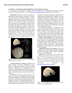
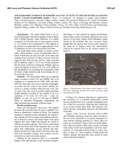
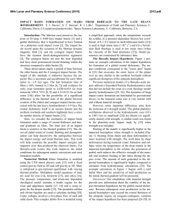
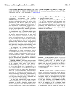
46th Lunar and Planetary Science Conference (2015)
1335.pdf
PHOTOGEOLOGIC MAP OF THE HELLAS BASIN FLOOR, MARS H. Bernhardt1, H. Hiesinger1, M.
Ivanov2, G. Erkeling1, O. Ruesch1, D. Reiss1 1Institut für Planetologie, Westfälische Wilhelms-Universität, WilhelmKlemm-Str. 10, 48149 Münster, Germany ([email protected]), 2Vernadsky Institute, Russian Academy
of Sciences, Kosygin St. 19, 119991 Moscow, Russia.
Motivation: Hellas Planitia on Mars is the secondlargest topographically well-defined impact structure
in the Solar System [e.g., 1] and has repeatedly been
interpreted as a major sink for volcanic [e.g., 2],
glacio-fluvial [e.g., 3] and aeolian [4] materials. The
basin hosts a suite of enigmatic landforms, which are
unique to this area and whose origins remain unclear,
e.g., the “honeycomb” [e.g., 5], “banded” [6], and
“reticulate” [e.g., 7] terrains. Despite its significance,
the last comprehensive mapping of the entire Hellas
basin floor was done in 2001 [8], pre-dating a wealth
of new remote sensing data acquired since then. All
subsequent publications focused on areas along the rim
[e.g., 9,10] or exclusively on specific landforms [e.g.,
11]. Therefore, and in order to synthesize all new observations, extrapolations, and interpretations by us
and previous authors, we mapped the entirety of the
Hellas basin floor at 1:1,000,000 (Fig. 1A,B), producing a 1:2,000,000 DIN-A0 photogeologic map. It is
part of an in-depth analysis of the geologic history of
the Hellas basin (see abstract #1336) and is intended to
serve as a basemap for future investigations, providing
better constraints on potential formation mechanisms
of the enigmatic landforms.
Data and methodology: Initial unit identification
and delimitation were performed on mid-infrared data
from the Thermal Emission Imaging System
(THEMIS) aboard Mars Odyssey. The THEMIS-IR
Daytime global mosaic (100 m/px) [12] provides a
gapless, homogeneous dataset mostly unaffected by
atmospheric dust, which otherwise compromises some
visible image data for the Hellas basin floor. To assess
thermophysical properties of the surface, we also used
the global thermal inertia mosaic based on THEMISIR [13]. In addition, we used mid- to high-resolution
visible image data from two Mars Reconnaissance
Orbiter (MRO) instruments, the Context Camera
(CTX; ~6 m/px) [14] and the High Resolution Imaging
Science Experiment (HiRISE; 25-50 cm/px) [15,16],
as well as Mars Orbiter Narrow Angle Camera (MOCNA; 1.4 - ~3 m/px) data [17] aboard Mars Global Surveyor (MGS). CTX covers most of the Hellas basin
floor, but it is less suitable as a mapping basis as the
inter-comparability of images is often limited by
changing lighting conditions, variable atmospheric
dust content, and seasonal surface frost. Also due to
atmospheric dust, only six images from the High Resolution Stereo Camera (HRSC; 12.5-50 m/px) on Mars
Express (MEx) [18,19] show the surface in sufficient
quality within the mapping area. Stereographic digital
terrain models (DTMs; 50 m/px) based on HRSC images [20] cover ~6% of the mapping area along the
northern and eastern basin rim and were used to greatly
improve topographic information in those regions,
especially on km- to sub-km-sized features. For the
remainder of the basin floor, the global DTM by the
Mars Orbiter Laser Altimeter (MOLA) with a horizontal resolution of 463 m/px served as topographic basemap [21]. For small-scale features we used MOLA
Precision Experiment Data Records (PEDR) with an
along-track spacing of 330 m and a vertical resolution
of ~1 m [22]. Wrinkle ridges (Fig. 1B, black lines)
were mapped on a high pass-filtered MOLA DTM,
improving their identification, especially when subdued [11].
We used standard contact types (certain, approximate, inferred, covered) as well as symbology defined
by the US Geological Survey and employed the general techniques for planetary mapping as outlined by
[23] and refined by [24]. The mapping area comprises
the landform-defined basin floor (approximated by the
-5,600 m contour; fig. 1B) as well as adjacent units. To
supplement our mapping with further unit characterization and interpretation, we also analyzed data from the
Gamma Ray Spectrometer (GRS, ~7 km/px) [25] and
Thermal Emission Spectrometer (TES; ~3 km/px) on
MGS [26]. Previous investigations based on hyperspectral data by both, the Compact Reconnaissance
Imaging Spectrometer for Mars (CRISM; 16-20 m/px)
on MRO [27,28], as well as the Observatoire pour la
Minéralogie, l'Eau, les Glaces et l'Activité (OMEGA)
on MEx [29-32], complemented our unit interpretations. In addition to relative dating via stratigraphic
analyses (Fig.1C), we acquired absolute model ages by
measuring crater-size frequency distributions on nine
map units using techniques described in [33,34], with
the aid of CraterTool in ArcGIS [35] and CraterStats
for plotting and fitting the distributions [36].
46th Lunar and Planetary Science Conference (2015)
1335.pdf
Figure 1: A) Simplified version of our photogeologic map of the Hellas basin floor (orthographic projection centered
at 43°S, 69°E; background: THEMIS-IR Daytime 100 m Global Mosaic version 11.6). Black line indicates path of
profile shown in (C). B) Same area showing the -5,600 m contour in red, wrinkle ridges in black with diamonds
(subdued ridges are dashed), and channel-like valleys in the vicinity of the basin floor in blue (uncertain/highly
degraded valleys in light blue). C) MOLA DTM-based profile illustrating our stratigraphic model of the basin floor
(path shown in (A)). Black arrows mark wrinkle ridges. Period extents for units labels based on [37]. For more detailed discussions of selected units see abstract #1336.
References: [1] Andrews-Hanna, J. C., & Zuber, M. T. (2010) GSA Special Paper, 465(01), 1–13. [2] Williams, D. A. et al. (2009) PSS, 57(8-9), 895–916. [3] Kargel, J. S.,
& Strom, R. G. (1992) Geology, 20, 3–7. [4] Howard, A. D. et al. (2012) LPSC (p. 1105). [5] Moore, J. M., & Wilhelms, D. E. (2001) Icarus, 154(2), 258–276. [6] Diot, X. et al.
(2014) PSS, 1–17. [7] Moore, J. M., & Wilhelms, D. E. (2007) USGS Geologic Investigations, 2953, 80225. [8] Leonard, G. L., & Tanaka, K. L. (2001) USGS Geologic Investigations, 2694, 80225. [9] Bleamaster, L. F., & Crown, D. A. (2010) USGS Geologic Investigations, 3096, 80225. [10] Mangold, N. et al. (2012) PSS, 72(1), 18–30. [11] Bernhardt,
H. et al. (2014) LPSC (p. 1366). [12] Christensen, P. R. et al. (2004) Space Sci. Rev., 110(1/2), 85–130. [13] Christensen, P. R. et al. (2013) LPSC (p. 2822). [14] Malin, M. C. et
al. (2007) JGR, 112(E5), E05S04. [15] McEwen, A. S. (2006) JGR, 112. [16] Delamere, W. A. et al. (2010) Icarus, 205(1), 38–52. [17] Malin, M. C., & Edgett, K. S. (2010) The
Mars Journal, 5, 1–60. [18] Neukum, G., & Jaumann, R. (2004) Mars Express: The Scientific Payload, 1–19. [19] Jaumann, R. et al. (2007) PSS, 55(7-8), 928–952. [20] Gwinner,
K. et al. (2009) Photogrammetric Engineering & Remote Sensing, 75(9), 1127–1142. [21] Smith, M. D. et al. (2001) JGR, 106(E10), 23689. [22] Zuber, M. T., & Smith, M. D.
(1992) JGR, 97(92), 7781–7797. [23] Wilhelms, D. E. (1990) Geologic Mapping. In Planetary Mapping (p. 312). [24] Tanaka, K. L. et al. (2009) PSS, 57(5-6), 510–532. [25]
Boynton, W. V. et al. (2007) JGR, 112(E12), E12S99. [26] Putzig, N. (2005) Icarus, 173(2), 325–341. [27] Murchie, S. (2007) JGR, 112(E5), E05S03. [28] Bandfield, J. L. (2013)
Icarus, 226(2), 1489–1498. [29] Poulet, F. (2007) JGR, 112(E8), E08S02. [30] Williams, D. A. (2010) EPSL, 294(3-4), 451–465. [31] Zalewska (Andrzejewska), N. (2013) PSS,
78, 25–32. [32] Zalewska (Andrzejewska), N. (2014) Water in the Deepest Crater of Mars. In Insights on Environmental Changes (pp. 65–76). [33] Neukum, G. (1983) Habil.
thesis, U. of Munich. [34] Neukum, G. et al. (2001) Space Sci. Rev. 96, 55-86. [35] Kneissl, T. et al. (2012) Planet. Space Sci. 59, 1243-1254. [36] Michael, G. and Neukum, G.
(2010) Earth Planet. Sci. Lett. 294, 223-229. [37] Ivanov, B. A. (2001). Sp. Sc. Rev., 96(1-4), 87–104.
© Copyright 2026