
Widespread Recurring Slope Lineae of Valles Marineris
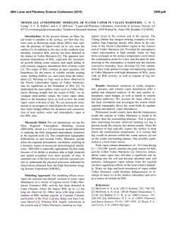
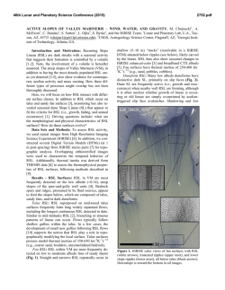
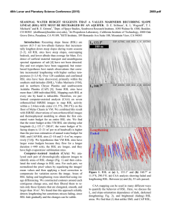
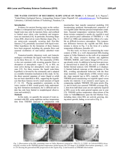
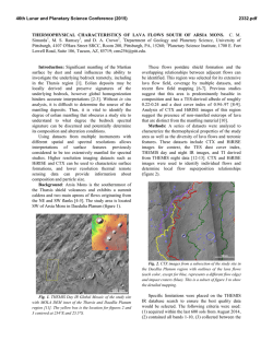
46th Lunar and Planetary Science Conference (2015)
2537.pdf
WIDESPREAD RECURRING SLOPE LINEAE OF VALLES MARINERIS. M. Chojnacki1, A. McEwen1, C.
Dundas2, L. Ojha3, and the HiRISE Team, 1Lunar and Planetary Lab, U.A., Tucson, AZ, 85721
([email protected]), 2USGS, Astrogeology Science Center, Flagstaff, AZ, 3Georgia Institute of Technology, Atlanta, GA.
Introduction and Motivation: Recurring Slope
Lineae (RSL) are narrow, dark linear markings that occur on steep, low-albedo slopes and incrementally grow,
fade, and reappear yearly. RSL are now confirmed to
occur in the mid-latitude southern highlands [1-2], a few
northern hemisphere locations [3] and several equatorial
sites [4]. Their preference for seasonally warm (generally sun-facing) slopes suggest the involvement of a volatile, possibly salty brines or fresh water [2-6]. However,
the exact formation mechanism and source of the putative water remain elusive.
Here, we describe the widespread and densely populated RSL detected within the deep canyons of Valles
Marineris. Additionally, we provide initial volumetric
water estimates for Coprates Chasma RSL. Collectively
these observations and estimates provide new constraints
on these unique phenomena.
Data Sets and Methodology: RSL were identified
using repeat images from High Resolution Imaging
Science Experiment (HiRISE) (~25 cm per pixel) [7].
Based on their behavior in available images, sites were
categorized as in McEwen et al. [1]. Fully confirmed
sites show RSL with recurrence (incremental growth
and fading) in multiple Mars years. Partially confirmed
sites are where slope lineae (SL) were detected to grow
incrementally or recur. Candidate sites have characteristic dark linear markings but have not (yet) been observed to change. Future data may raise the status of
these latter two categories. In addition, “potential”
RSL sites were mapped using lower-resolution Context
Camera (CTX) data (~6 m per pixel) showing characteristic fans, but will require repeat HiRISE for confirmation. Using ArcGIS software, areal coverage of
RSL surfaces was mapped in HiRISE images to estimate volumetric values of the putative water involved.
Results – Mapping of RSL: Thirty RSL sites have
been identified and are monitored using HiRISE within
Coprates (21) and Melas (9) chasmata. Fifteen of these
are fully confirmed, nine are partially confirmed, and
six are candidate sites. These RSL locations occur on a
variety of landforms, including craters, landslide scarps,
canyon walls, central mounds, and dune forms [8]. Often, bedrock source areas feed steep slopes of talus
and/or sandy fans (Fig. 1, right inset) [4,8-9]. At some
locations, RSL flow on multiple slope aspects depending on the season. RSL often populate a majority of the
terrain covered in the HiRISE field of view.
New mapping using CTX shows hundreds of potential RSL locations, particularly on the south wall of Melas and west-central portions of Coprates (Fig. 2). Along
with subtle indicators of SL clusters, these sites show
distinct fans with dark, upslope fringes below wall spur
bedrock or talus contacts (Fig. 1, left inset) – a morphology characteristic of Valles Marineris RSL sites.
Fans show seasonal changes in overlapping CTX data,
similar to what has been observed with HiRISE at confirmed sites [4]. Several early sites identified in this
manner using CTX data have been partially or fully
confirmed using follow up HiRISE targeting.
Figure 1. CTX view of widespread HiRISE confirmed (green) and CTX potential (orange) RSL in central Coprates
Chasma. (left inset) Many locations without HiRISE show fans with dark, upslope fringes (arrows) – a frequent indicator
of RSL. (right inset) Confirmed RSL form on fans below spurs (ESP_034830_1670). Downslope and North are to the
bottom of the image. See Fig. 2 for location. CTX image D21_035252_1672_XN_12S064W.
46th Lunar and Planetary Science Conference (2015)
Table 1. Coprates RSL water budget estimates
Status
Surface
Volume* (m3) Volume*
2
Area (m )
at 10mm
(m3) at 1m
7
4
All HiRISE
1.9×10
7.4×10
7.4×10⁶
7
4
Confirmed
1.1×10
4.3×10
4.3×106
*40% porosity is assumed
Water budget estimates: We mapped all the
HiRISE-monitored RSL sites in Coprates Chasma
where flows or seasonal albedo changes occurred. Areal measurements were collected of the bedrock surfaces where the RSL appear to have been sourced
from, as well as the lower-lying talus or sandy fan surfaces. Seasonal RSL darken the local surface relative
to adjacent areas, but the related fans they form on also
show larger-scale albedo darkening in HiRISE [4] and
CTX images. Recent spectral measurements from laboratory studies indicate darkening can be significant
even with minimal amounts of water (5 wt%) [10].
Assuming this minimal number and a dry regolith density of 2,000 kg m-3 would yield 10 vol% for RSL subsurfaces. 10 mm is assumed to be the thinnest porous
layer in which water could flow [5]. Volumetric fluid
estimates at 10 mm and 1 m depth for all HiRISE sites
and for only those that are fully confirmed are listed in
Table 1. Minimal (10 mm depth) estimates are also
shown graphically in Fig. 2. We note that although
these are plausible estimates we have no direct measurements of the flow depth. We estimate that the likely
RSL regions mapped from CTX data are double the
area of those mapped with HiRISE data, so estimated
minimal water for all RSL (at 10 mm) in this region is
~2.2×10⁵ m3. These estimates are for images with RSL
taken between years 2007–2014 and over many sea-
2537.pdf
sons, but do not imply these volumes existed at any
single time.
Discussion: Valles Marineris RSL are detected
among diverse geologic landforms and surfaces [8-9].
Sites appear to be very densely populated with active
RSL over a broad elevation distribution (–5.1 km to
+3.7 km [8]) spanning a greater range than other RSL
locations on Mars. RSL frequently appear to originate
from local topographic highs within 100 m of ridge
crestlines or summits [8]. Any proposed water source
needs to explain these observations and the large volume estimates described herein.
Mars’ atmosphere contains an average of ~10 precipitable microns of water [11], for a total volume of
1.4×10⁹ m3. However, the atmosphere above this region of Valles Marineris (~5° lat. × 15° lon.) is ~106
m3, about 4.5× our minimum estimate for RSL water.
An atmospheric source of the water is possible if there
is an efficient mechanism to trap the water in the shallow subsurface, perhaps by deliquescence [12], and if
evaporation is suppressed by salts or lag deposits.
Acknowledgements: Funding for this work came in part
from NASA MDAP grant NNX13AK01G.
References: [1] McEwen A. et al. (2011) Science, 333,
740–743. [2] Ojha L. et al. (2014) Icarus, 231, 365–376. [3]
Dundas C. et al. (2014) GSA, abstract 329–5. [4] McEwen A.
et al. (2014) Natu. Geo., 7, 53–58. [5] Grimm R. (2014) Icarus, 233, 316–327. [6] Stillman D. et al. (2014) Icarus, 233,
328–341. [7] McEwen A. et al. (2007) JGR, 112, E05S02.
[8] Chojnacki M. et al. (2014) LPSC XLV, abstract 2701. [9]
Chojnacki M. et al. (2015) This Conference. [10] Massé M.
et al. (2014) Plan. and Spac. Sci. 92, 136–149. [11] Smith M.
(2008) AREPS 36, 191–219 [12] Wang et al. (2014) 8th Inte.
Conf. Mars, abstract 2606.
Figure 2. THEMIS day infrared of western Coprates Chasma showing some the most densely populated RSL region on
Mars detected to date. Also shown, volumetric estimates (blue circles) of HiRISE monitored sites, based on areal measurement and assuming flows are 10 mm deep. Gradational circles range from 300 m3 to 8,300 m3 for the smallest and
largest sites, respectively. Dune fields are mapped in white.

© Copyright 2026