
GEOLOGIC HISTORY OF MARGARITIFER BASIN, MARS
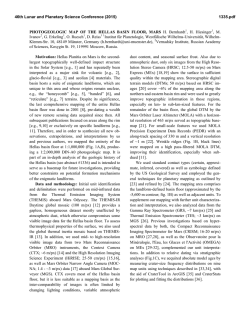
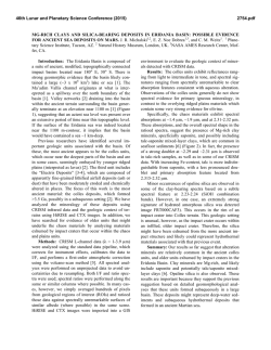
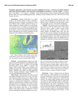
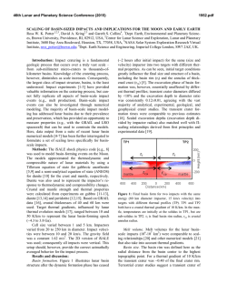
46th Lunar and Planetary Science Conference (2015)
1463.pdf
GEOLOGIC HISTORY OF MARGARITIFER BASIN, MARS: EVIDENCE FOR A PROLONGED YET
EPISODIC HYDROLOGIC SYSTEM. M. R. Salvatore1, M. D. Kraft1,2, C. S. Edwards3, and P. R. Christensen1,
1
School of Earth and Space Exploration, Arizona State University, 201 E. Orange Mall, Tempe, AZ, 85287-6305,
[email protected]; 2Western Washington University, Bellingham, WA; 3U.S. Geological Survey, Flagstaff, AZ.
Introduction: Located within the “Tharsis trough
[1],” Margaritifer Basin is a critical component of the
martian hydrologic system [2] (Fig. 1). This basin is located at the terminus of the Uzboi-Ladon-Morava (ULM)
network of mesoscale outflow channels, which drains
nearly 9% of the martian highlands [1-4]. Margaritifer
and Iani Chaos separate the ULM system and Margaritifer Basin from Ares and Mawrth Valles to the north,
which eventually debouche into the northern lowlands.
Together, this network of valleys, basins, and chaos terrain extend for more than 8,000 km [5].
The geologic history of Margaritifer Basin has not
been fully explored using recent orbitally derived datasets. Therefore, we investigate the topographic, morphological, and spectral character of the geologic units of
Margaritifer Basin using high-resolution datasets. We
then reconstruct the geologic history of this basin based
on observed stratigraphic relationships. Our results indicate that Margaritifer Basin experienced fluvial, volcanic,
and possible lacustrine activity throughout its history,
with potentially long temporal gaps between many of
these events. These results suggest that Margaritifer Basin
experienced prolonged yet episodic hydrological activity.
Methods: Mars Orbiter Laser Altimeter (MOLA [6])
gridded and profile data were used for topographic analyses. Mars Orbiter Camera (MOC [7]), Context Camera
(CTX [8]), Thermal Emission Imaging System (THEMIS
[9]), and High Resolution Imaging Science Experiment
(HiRISE [10]) visible imagery was used for surface and
stratigraphic analyses. Compact Reconnaissance Imaging
Spectrometer for Mars (CRISM [11]) data were used for
visible/near-infrared spectral analyses, while THEMIS
and Thermal Emission Spectrometer (TES [12]) data
were used for thermal infrared compositional and thermophysical analyses [13].
Results: Four significant geologic units have been
identified within Margaritifer Basin based on their unique
geologic properties. Here we describe these units, ordered
from highest to lowest mean elevation:
Unit 1 (-1790 m). High-standing mountains within
Margaritifer Basin are classified as Unit 1. These mountains stand up to one kilometer above the basin floor, and
are spectrally, morphologically, and thermophysically
similar to the surrounding plains of Margaritifer Terra.
The mountains also exhibit fluvial dissection and muted
landscapes, suggesting that they are ancient.
Unit 2 (-2130 m). The majority of the flat-lying plains
in Margaritifer Basin are grouped into Unit 2. CRISM,
TES, and THEMIS analyses suggest that Unit 2 is basal-
tic in composition, with many areas exhibiting high abundances of olivine (> 20%). While the majority of Unit 2 is
sparsely cratered and smooth, an olivine-enriched subunit
is hummocky and polygonally fractured, exhibits a higher
thermal inertia (315 J m-2 K-1 s-0.5, relative to < 300 J m-2
K-1 s-0.5), and is stratigraphically below the smoother subunit of Unit 2. This olivine-rich subunit is also found
within Morava Vallis, where it is fluvially dissected.
Unit 3 (-2210 m). Located only in western Margaritifer Basin, Unit 3 is light-toned, heavily cratered, and exhibits the highest thermal inertia measured throughout the
basin (> 350 J m-2 K-1 s-0.5). Many craters are infilled by
material associated with Unit 3, suggesting that this material was deposited on already cratered terrain. Fine-scale
layering is observed where the subsurface of Unit 3 is
exposed by impact craters. CRISM data show strong 1.4
µm, 1.9 µm, and 2.3 µm absorption features, indicative of
the presence of Fe/Mg phyllosilicates.
Unit 4 (-2330 m). Unit 4 is only present along the
floor of Morava Vallis. This unit has a thermal inertia
comparable to Unit 2 (315 J m-2 K-1 s-0.5), yet lacks any
diagnostic spectral signatures. The most diagnostic property of Unit 4 is the complex network of polygonal fractures, in addition to numerous long ridges that exhibit
raised margins and extend for several kilometers.
Geologic History of Margaritifer Basin: Based on
the properties and stratigraphic relationships of these geologic units, we are able to recreate the geologic history of
Figure 1. MOLA topography of Margaritifer Basin overlain on
THEMIS daytime infrared imagery. A transect shown in Figure
2 is also identified.
46th Lunar and Planetary Science Conference (2015)
Margaritifer Basin (Fig. 2). Fluvial and/or lacustrine sedimentation (Unit 3) occurred in western Margaritifer Basin, associated either with the initial activity in Morava
Vallis or with the more highly integrated fluvial networks
present throughout the nearby southern highlands (Fig.
2b). Unit 4 either predates the emplacement of, or was
deposited contemporaneously with, Unit 3. Morava Vallis
dissected Margaritifer Basin and continued to the north,
eroding through several impact craters to the east of Margaritifer Chaos (Fig. 2b). Margaritifer Basin was then
resurfaced by basaltic volcanism (Unit 2), which nearly or
completely obscured Morava Vallis (Fig. 2c). The widespread formation of chaos terrain occurred following volcanic resurfacing, exposing both light-toned sedimentary
layers and olivine-bearing basalts in the isolated mesas
within the chaos terrain. The reactivation of Morava Vallis followed chaos formation, as the current extent of Morava Vallis terminates at a small and isolated patch of
chaos terrain located in the center of Margaritifer Basin.
This later activation of Morava Vallis carved through
basaltic materials associated with Unit 2 and, in places,
exposed Unit 4 (Fig. 2d).
Implications: The clear evidence for multiple episodes of fluvial activity within Morava Vallis that are
temporally separated by basaltic volcanism suggests that
the martian hydrologic system had been episodically active for a prolonged period of time. While the exact timing of these events is not well constrained, evidence of
lava-water interactions (e.g., lava deltas, littoral cones,
rootless cones, tuyas) are absent [14]. This may suggest
that water was absent from Margaritifer Basin before the
volcanic resurfacing occurring, and that these volcanic
surfaces had cooled and solidified prior to the reactivation of Morava Vallis. Alternatively, evidence of lavawater interactions may have been buried by subsequent
volcanism. Therefore, it is impossible to determine the
exact length of time separating these geological events.
Episodic fluvial activity, however, suggests episodic
recharge upstream from Morava Vallis. If the water was
sourced from precipitation, this episodicity may be associated with global climatic or orbital cycles that recharged
the atmospheric and/or subsurface water reservoirs [1517]. If the water was sourced from the subsurface, episodic melting of the cryosphere [18] or overpressurization of
an aquifer [19] may have resulted in the observed geologic history. Although only two discrete episodes of fluvial
activity can be confidently identified in Margaritifer Basin, this study confirms that one single catastrophic event
did not form the mesoscale outflow channels located in
the Tharsis trough. Recharge of surface and/or subsurface
reservoirs must have occurred to produce the observed
morphologies and stratigraphy. Such episodic recharge
and hydrological activity may, therefore, be representative of the martian hydrological system as a whole.
1463.pdf
References: [1] Phillips R. et al. (2001), Science, 291,
2587-2591. [2] Grant J. & Parker T. (2002), JGR, 107,
10.1029/2001JE001678. [3] Banerdt W. (2000), AGU Fall
Mtg., 81, P52C-04. [4] Irwin R. & Grant J. (2013), USGS Map,
3209. [5] Parker T. (1989), LPSC XX, 826-827. [6] Smith D. et
al. (2001), JGR, 106, 23689-23722. [7] Malin M. & Edgett K.
(2001), JGR, 23429-23570. [8] Malin M. et al. (2007), JGR,
112, 10.1029/2006JE002808. [9] Christensen P. et al. (2004),
Space Sci. Rev., 110, 85-130. [10] McEwen A. et al. (2007),
JGR, 112, 10.1029/2005JE002605. [11] Murchie S. et al.
(2007), JGR, 112, 10.1029/2006JE002682. [12] Christensen P.
et al. (2001), JGR, 106, 23823-23871. [13] Fergason R. et al.
(2006), JGR, 111, 10.1029/2006JE002735. [14] Goudge T. et
al. (2012), JGR, 117, 10.1029/2012JE004115. [15] Craddock
R. & Howard A. (2002), JGR, 107, 10.1029/2001JE001505.
[16] Andrews-Hanna J. et al. (2007), Nature, 446, 163-166.
[17] Andrews-Hanna J. & Lewis K. (2011), JGR, 116,
10.1029/2010JE003709. [18] Chapman M. & Tanaka K.
(2002), Icarus, 155, 324-339. [19] Warner N. et al. (2011),
JGR, 116, 10.1029/2010JE003787.
Figure 2. Hypothesized geologic history of Margaritifer Basin,
from earliest (a) to latest (d). Grey, pink, blue, and maroon units
represent Unit 1, Unit 2, Unit 3, and Unit 4, respectively. (a)
Margaritifer Basin prior to modification. (b) Sedimentary deposition within the basin, associated with fluvial and/or lacustrine
processes. (c) Volcanic resurfacing throughout the basin. (d)
Reactivation of Morava Vallis following chaos formation.


© Copyright 2026