
PONDING, DRAINING AND TILTING OF THE CERBERUS PLAINS
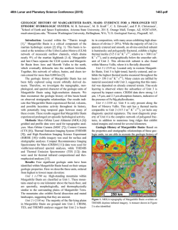
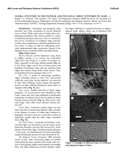
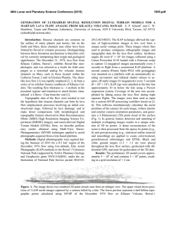
46th Lunar and Planetary Science Conference (2015)
1961.pdf
PONDING, DRAINING AND TILTING OF THE CERBERUS PLAINS: A CRYOLACUSTRINE ORIGIN
FOR THE SINUOUS RIDGE AND CHANNEL NETWORKS IN RAHWAY VALLIS, MARS. J. D. Ramsdale1, M. R. Balme1, 2, S. J. Conway1, C. Gallagher. 1Dept. Physical Sciences, Open University, Walton Hall, Milton
Keynes, MK7 6AA ([email protected]). 2Planetary Science Institute, Suite 106, 1700 East Fort Lowell,
Tuscon, AZ, USA.
Introduction: Rahway Vallis (Fig. 1) is a valley
system in the Cerberus Plains of Mars containing a
branching network of channels converging on a basin
floor. Rahway Vallis is shallow (around 15 metres vertically compared to channel widths of several kilometres) and has convex to rectilinear cross-profiles that
are consistent in form across the whole Rahway basin.
In this study, we aim to discriminate between possible
fluvial, glaciofluvial and volcanic hypotheses for the
formation of the landforms in the Rahway basin.
tive relief. Lastly, the transition between the older
heavily cratered highland terrain and the floor of the
Rahway basin is bounded by near-horizontal continuous topographic terraces, with step-like morphology.
Analysis: The terraces occur at a consistent elevation: between 3100 and 2850 m below Mars datum.
Moreover, when a plane is fitted to these terraceelevations, they conform closely (+/- ~50m) to a consistent, shallow, east-dipping linear trend. This suggests that these terraces represent the high-stand margins of a once-liquid, basin-filling material that formed
an equipotential surface. This result is consistent with
these features being the result of an infilling of the topography by a fluid that was then removed by drainage.
Fig. 1 Map of Rahway, black outline marks edges
of the Rahway basin, blue lines mark the channel system. (Inset marks location on global MOLA DEM).
Methods: Geomorphological analysis and mapping were performed primarily using publically available Context Imager (CTX ~6 m/pixel; [1]) and High
Resolution Stereo Camera (HRSC; 12 m/pixel; [2])
images. MOLA (Mars Orbiter Laser Altimeter; [3])
gridded and point data, THermal EMission Imaging
System (THEMIS; [4]), HRSC and High Resolution
Science Imaging Experiment images (HiRISE; [5])
were used for additional detail and context.
Observations: Both channels and valley descend
and deepen consistently from west to east. The channels widen down-slope and increase in width at confluences. The morphology and topology of this channel
system are consistent with formation by contributory
fluid flow, generated from a continuous source or many
distributed sources. In addition to the valley and channel network, we have identified a series of sinuous
ridges in the Rahway basin (Fig. 2). The branching
pattern of this ridge network is reminiscent of fluvial
systems, although the branching landforms are in posi-
Fig. 2 (a) sketch map of locations of ridges in central
Rahway, grey lines represent Rahway channels and
black lines represent sinuous ridges; locations of parts
(b-d) of HiRISE image PSP_003623_1900 are indicated by black boxes. (b)Shows intersection of ridges with
Rahway channel (c) Shows ridge turning to parallel to
Rahway, (d) Shows examples of ridges in troughs.
Discussion: Figure 3 illustrates that the Rahway
Vallis system as a whole appears to be consistent in
form and morphometry with a fluvial origin, although
immature as a system compared to a terrestrial river
network. The sinuous ridges resemble eskers, possible
even eskers set within subglacial canals or tunnel channels. However, there is no other evidence of wet/warmbased glaciation in the region. Consequently, if eskers
at all, the sinuous ridges are supraglacial eskers, a type
that can form on the surface of dry/cold based glaciers,
or they are ridges formed in a cryolacustrine environment by thaw-water draining off the surface, or from
46th Lunar and Planetary Science Conference (2015)
within a non-glacial ice-body that filled the Rahway
basin. Both scenarios have analogues in the Antarctic
[7, 8].
The current gently tilting trend of the terraces implies either that (a) a material filled the Rahway basin
and was of low viscosity and continuously flowed in an
approximately easterly direction, or (b) the Cerberus
plains have been tectonically tilted post-formation, and
that the terraces were once at the margins of an equipotential surface. A hypothesis of lake drainage, occurring perhaps as a consequence of an ice or debris-dam
failure within (or during the formation of) Marte Vallis,
as suggested by Burr et al [6, 9], is most consistent
with the evidence, but does not offer a clear explanation for the ridge systems. However, any lake forming
on Mars would freeze at its surface, and perhaps at its
base, so if the lake was not immediately drained after
formation it could have frozen to many metres deep,
perhaps even to its base [10]. It is possible that the
sinuous ridges formed by sedimentation associated
with draining of thaw fluids from the top of a frozen
lake, or by draining of unmelted portions of the frozen
body. It is unlikely that the ridges could have formed
from pressure-melting at the base of an entirely frozen
ice-body of such a shallow depth, so they cannot be
eskers in the strict glacial sense. Following this hypothesis, glaciofluvial-lacustrine activity was followed
by tilting, leading to the trend in elevation seen today.
A mechanically similar hypothesis of very fluid lavas infilling, partially solidifying, and then draining,
might also be possible (Fig. 3c). However, this mechanism is difficult to reconcile with the fact that such
lavas would have had to have remained liquid while
travelling extensive distances from source across very
shallow slopes, carving a series of channels, forming a
single, ponded body with a volume of 1500 km3, and
then draining.
Conclusions: Rahway Vallis has a ~500 km long,
branching channel network with a distributed source.
Terrace-like forms bounding Rahway’s basin could be
since-tilted, high-stand deposits. Branching sinuous
ridges beside the Rahway channels are esker-like in
form and size. No other evidence for glacial origin is
found within the Rahway region. Our favoured interpretation is for a rapidly filled and then drained lake,
which was probably deeply frozen in places. A volcanic hypothesis remains possible, if a model that maintains lava fluidity is found, but does not explain as
many observations as a fluvial one.
References: [1] Malin, M. C. et al. (2007) JGR
112. [2] Neukum, G. & Jaumann, R. (2004) Mars Express: the Scientific Payload 1240, 17–35. [3] Smith,
D. E. et al.. (1993) JGR 1943, 14–18. [4] Christensen,
P. R. et al. (2004) Space Sci. Rev. 110, 85–130. [5]
McEwen, A. S. et al. (2007) JGR 112. [6] Burr, D. M.,
1961.pdf
et al. (2002) JGR Lett. 29,. [7] Fitzsimons, S. (1991)
Geomorphology 4, 293–299. [8] Hambrey, M. J. &
Fitzsimons, S. (2010) Sedimentology 57,. [9]. Burr, D.
M., et al.. (2002) Icarus 159, 53–73. [10] Carr, M. H..
(1983) Icarus 56, 476–495.
Fig. 3 (a) The landforms currently present in the Rahway basin. (b) A cryolacustrine scenario. (c) A volcanic scenario. The following features are indicated by
the roman numerals: (i) basin-marginal ridges, (ii)
outliers with terraces and ridges on their margins, (iii)
sinuous ridges on channel margins, (iv) basinmarginal terraces, (v) remnant ‘plates’, (vi) infilling
material within channels, with grooves in the infilling
material showing further channel development, (vii)
infilling of Marte Vallis and backfilling into Rahway
Vallis; whether Marte Vallis was carved prior to the
formation of the channels, ridges and terraces within
the Rahway basin is unclear, (viii) although it lies outside the spatial extent of this project, reconnaissance
observations show that there are similar-terrace like
features south of Marte Vallis, (ix) Crevasses with sediment fill on margins of cryolake, (x) sediment deposition in sub-, en- , and/or supra-ice channels, (xi) terraces form on the margins through deposition of sediment on the margins as the cryolake thaws and drains
and/or through ice shielding the lower topography
from aeolian erosion, (xii) remnant lava plates on the
surface that likely formed contemporaneously with the
lavas of the Cerberus Plains that the Rahway channels
and valleys are carved into, (xiii) drainage from the
Rahway basin onto Amazonis Planita through the proto-Marte Vallis, (xiv) push up ridges formed between
lava plates, remnant plates, (xv) lava plates formed on
the surface of ponded lavas and deposited on the surface as the lava is then drained, (xvi) terraces form on
the margins of the lava lake due to erosion, deflation
and/or grounding of lava plates that were attached to
the basin margins.
© Copyright 2026