
Abstract
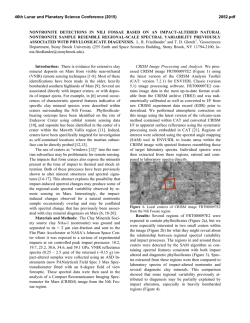
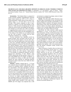
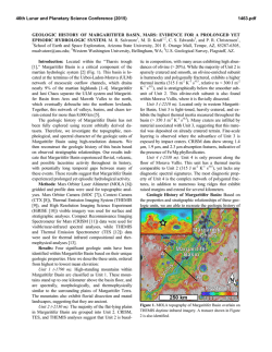
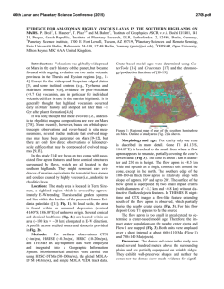
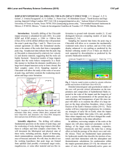
46th Lunar and Planetary Science Conference (2015)
2090.pdf
STRATIGRAPHY OF OLIVINE–CARBONATE–BEARING UNITS FORMING MESAS AND LINEAR
FEATURES IN NORTHEAST SYRTIS MAJOR: IMPLICATIONS FOR EMPLACEMENT. M. S. Bramble1
and J. F. Mustard1, 1Dept. of Earth, Environmental, and Planetary Sciences, Brown University, Providence, RI,
02912 ([email protected]).
Introduction: The Northeast Syrtis Major region of
Mars features a diverse set of geologic units where the
exposed stratigraphy has distinct units hosting phyllosilicates, carbonates, and sulfates [1,2], likely recording the chemical evolution of waters towards acidic pH
[2], and hosts distinct ridge networks that possibly
served as conduits for fluid flow [3]. In this contribution, we are investigating the detailed stratigraphy of a
set of geologic units constrained within distances of
several 10s of km to understand the spatial and temporal relationship of the mafic unit variably altered to
carbonate [2,4]. The origin of this unit is controversial
[1,5,6], but systematically studying it at the highest
spatial resolution will help clarify its provenance.
Methods: Morphological mapping of the study area
(~17–18.5 °N and 76–78 °E) was performed using
high-resolution imagery and Geographic Information
Systems (GIS). Separate basemaps were made using
data from the High Resolution Imaging Science Experiment (HiRISE) [7] and the Context Camera (CTX)
[8]. Following [1,2], the spectral properties of the morpho-geologic units were characterized using the Compact Reconnaissance Imaging Spectrometer for Mars
(CRISM) to identify the correlating mineral signatures
[9]. The stratigraphic relationships between the units
were assessed using Digital Elevation Models (DEM)
produced with the NASA Ames Stereo Pipeline and
HiRISE stereo pairs [10,11].
Geological Units of Interest: Within Northeast
Syrtis Major is a key geologic unit that consists of
three individual but related components that frequently
form mesas (Figure 1), henceforth termed the Mesa
Forming Unit (MFU). The uppermost unit displays a
rough, corrugated, crater-preserving surface, topping a
middle unit consisting of slopes shedding both light
and dark-toned boulders variably exposing larger lighttoned blocks. The matrix of this middle layer appears
darker in tone. Where the exposure is excellent some
mesas display banding in this middle unit and/or a lack
of boulder shedding. The lowermost component of the
MFU is an extensive basal unit surrounding the mesa,
and frequently extending at great distance beyond the
vertical extent of the mesa. Light-toned blocks of various sizes are seen closely packed in this component
amongst a darker matrix, and a sharp contact is seen
with neighboring units, commonly smooth plains. Variable banding is observed in the lowermost unit. These
mesas likely correlate with the olivine-carbonate units
in the southwest similarly topped with a crater-
preserving surface and prominent layering on the
slopes [1,2,4,12].
Figure 1: (A) HiRISE subframe of ESP_015942_1980 showing
Mesa Forming Unit (MFU) and A–A’ profile in (C). (B) Perspective
view from the top right in (A) of MFU taken from a DEM made
with the above image and ESP_016443_1980 5x vertical exaggeration. (C) Cross section of a MFU showing (a) the crater-preserving
cap unit, (b) the boulder-shedding slopes, (c) the carbonate-bearing
basal unit, and (d) the Fe/Mg phyllosilicate-bearing basement.
Beneath this is a light-toned rough-surfaced unit
with darker-toned gradual slopes extending out towards
smooth plains. This Knobby Crustal Unit (KCU) is
frequently observed as large coherent expressions or
dispersed but coherent smaller knobs.
46th Lunar and Planetary Science Conference (2015)
Two distinct linear features are observed throughout
the study region. One category of linear features are 1–
5 m in height and width and several 100s of m long and
are seen in varying states of exposure. These ridges are
erosionally resistant, exposed in exhumed terrains, and
have been characterized previously [3] to be breccia
dykes formed during impact events [13] or fractures
mineralized through sub-surface fluid flow [3]. These
ridges are abundant in the southwest of the study area
and decrease in abundance towards the northeast.
Figure 2: Spectra from the (a) MFU cap unit, (b) LLF, (c) lowermost MFU component, and (d) KCU. Spectra in (a), (c), and (d)
from image FRT00016A73, and (b) from FRT0001642E. Colors
correlate with those in Figure 1C.
We refer to the second category of linear features as
Large Linear Features (LLF). They are 10s to 100s of
m wide and 1000s of m long. Unlike the more common
raised ridges the LLF are variable in height, sometimes
exposed as raised ridges and sometimes as recessive
troughs. Furthermore the LFF are commonly bounded
by raised rims of a light toned material. Exhibiting a
quasi-linearity, some are straight up to ~6 km, and
some exhibit gradual or sharp bending. Where exposed
the material comprising the LLF display is light-toned
and blocky. A gradation in scale of the LLF is observed from sizes comparable to the linear ridge networks to those on the order of several km. The features
appear stratigraphically related to lowermost layer of
the MFU as they are seen to join with edges of this
layer and grade into an extensive coherent basal unit.
Preliminary Spectral Analysis: CRISM spectra of
the units are shown in Figure 2. CRISM spectra collected of the MFU crater-preserving surfaces and ratioed to a spectrally bland region display a flat, unremarkable spectrum. The lowermost unit of the MFU
and the extended LLF share a similar spectral signature
displaying a broad 1 µm olivine absorption, and absorptions at 1.9, 2.3, and 2.5 µm. These spectra match
the olivine-carbonate unit spectra identified elsewhere
in Northeast Syrtis Major [2,4]. CRISM spectra collected of the KCU and ratioed to spectrally bland areas
also display an unremarkable spectrum.
2090.pdf
Relationships and Interpretations: The spectral
features of olivine and carbonates in the LLF and the
MFU are similar to the olivine-carbonate units to the
southwest with magnesite alteration at base of the
mafic unit [4]. These units are observed in topographic
lows superimposed on basement rocks, and appear to
be embedded units with the magnesite alteration observed at the edges of the rough, crater-preserving surface. In the northeast, the MFU and extended LLF
mapped here are likely expressions of a related geologic unit, but one where the surrounding basement rocks
have been eroded away leaving the LLF exposed on the
smooth plains. The boulder-shedding slopes and craterpreserving surface have eroded back revealing the LLF
over large areal extents, and generating dispersed mesas in regions of increased erosional resistance. This
extends the observations of olivine-carbonate outcrops
throughout Northeast Syrtis Major, from the units in
the area of the Syrtis Major lava flows towards the
southwest rim of Jezero Crater.
The relationship between the mapped units allows
inferences about the pre-existing topography. The resistant unit forming the LLF appears to fill fractures or
depressions present in the basement at the time of emplacement. The MFU appears to embay the KCU, and
LLF appear in present-day troughs between select larger coherent KCU. In other regions it appears on smooth
plains, perhaps as the remnants of advanced erosion.
The question remains as to the source of the MFU
with its distinctive olivine-carbonate mineralogy. Two
competing hypotheses describe the olivine-rich unit as
the result of lava flowing into the region after the Isidis
impact [6], or emplaced via the Isidis melt sheet [1,5].
The olivine-carbonate units, expressed as the LLF and
lowermost component of the MFU, are observed to
drape topography, appear in topographic lows, and
exhibit quasi-circular morphologic structures. These
observations appear to agree well with a more erosionresistant layer being emplaced by filling fractures,
lows, and craters in an initial surface rather than fluid
from a volcanic or mantle-tapping source filling to an
equipotential surface. The LFF and MFU may prove
valuable for providing a layer for relating the regional
stratigraphy that appears to extend throughout Northeast Syrtis Major.
References: [1] Mustard J. F. et al. (2009) JGR, 114, E00D12.
[2] Ehlmann B. L. and Mustard J. F. (2012) GRL, 39, L11202. [3]
Saper L. and Mustard J. F. (2013) GRL, 40, 245–249. [4] Mustard J.
F. and Wiseman S. M. (2014) LPS XLV, Abstract #2583. [5] Mustard J. F. et al. (2007) JGR, 112, E08S03. [6] Tornabene L. L. et al.
(2008) JGR, 113, E10001. [7] McEwen A. S. et al. (2007) JGR,
112, E05S02. [8] Malin M. et al. (2007) JGR, 112, E05S04. [9]
Murchie S. et al. (2007) JGR, 112, E05S03. [10] Broxton M. J. and
Edwards L. J. (2008) LPS XXXIX, Abstract #2419. [11] Moratto Z.
M. et al. (2010) LPS XLI, Abstract #2364. [12] Ehlmann B. L. et al.
(2008) Science, 322, 1828–1832. [13] Head J. W. and Mustard J. F.
(2006) MAPS, 41, 1675–1690.
© Copyright 2026