
1918
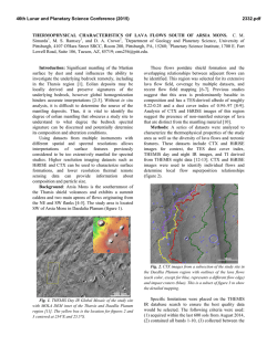
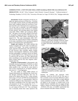
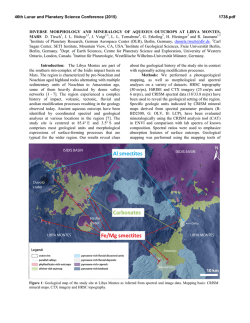
46th Lunar and Planetary Science Conference (2015)
1918.pdf
CHLORIDES PREDATED CLAY IN A LACUSTRINE ENVIRONMENT ON MARS AND ITS
ASTROBIOLOGY APPLICATION. Jun Huang1, M. R. Salvatore2, P. R. Christensen2 and Long Xiao1, 1 Planetary Science Institute, China University of Geosciences, Wuhan, Hubei, P. R. China ([email protected]),
2
School of Earth and Space Exploration, Arizona State University, Tempe, AZ, USA
Introduction:
Globally distributed chloridebearing materials have been previously identified on
Mars [1] using spectral data from Thermal Emission
Imaging System (THEMIS) [2] and Thermal Emission
Spectrometer (TES) [3]. These chloride salts (chlorides)
are indicators of near-surface water activity in the past,
and could have provided habitable environments for
haophilic microorganisms and preserved organic matter [4]. However, previous studies have shown many
chlorides occurred in local topographic depressions
without clear geologic or stratigraphic context [5]. In
addition, phyllosilicates have been found to underlie
chlorides [6, 7] in many locations, suggesting that these deposits are stratigraphically younger than their
surroundings. This proposed young age is not favorable from an astrobiological perspective, given the most
likely habitable surface environments on Mars would
have occurred very early in martian history [8]. Here
we identify the coexistence of chlorides and
phyllosilicates in a basin west of Knobel crater (near
Gale crater), and show that these chlorides are
stratigraphically below iron-magnesium smectite clays.
The two distinct depositional events in this MiddleNoachian [9] lacustrine environment can shed light on
an environment with interesting astrobiological implications. As such, this site should be considered as a
potential site for future martian surface investigations.
Methods:
We used imaging data from the
THEMIS global mosaic (~100 m/pixel) [2,10] and
gridded topographic data from the Mars Orbiter Laser
Altimeter (MOLA; 128 ppd) [11] to show the overall
regional context. Decorrelation stretch (DCS) [12]
images of THEMIS and Compact Reconnaissance Imaging Spectrometer for Mars (CRISM) [13] are used to
visualize compositional variations. Spectral information was extracted from CRISM FRT data (~18
m/pixel) and compared to library mineral spectra.
THEMIS nighttime infrared (IR) data were used to
calculate thermal inertia [14]. We further characterized
local and detailed geomorphology using Context Camera (CTX: ~6 m/pix) [15] and High Resolution Imaging Science Experiment (HiRISE: ~30 cm/pix) images
[16].
Results: Our investigation focuses on a topographically enclosed basin approximately 3000 km2 in area
centered near 6.078 °S, 132.346 °E (Fig. 1a). Lighttoned materials can be seen throughout the study region; the largest occurrence is in the northern part of
the fan unit, and tens of smaller occurrences are in
isolated “geologic windows” (Fig. 2). These lighttoned materials with elevated thermal inertia (Fig. 1b)
appear blue (Fig. 1c) in DCS [12] images of THEMIS
band 8, 7 and 5 , which is unique to chloride salts [1,
5]. CRISM data were also used to identify and map
hydrated materials throughout this basin. In Figure 1d,
the red, green and blue channels are assigned to 1.8,
2.38 and 1.15 μm, respectively. This combination
causes phyllosilicate-bearing materials to appear red
and orange, chloride-bearing materials to appear blue,
and low-calcium pyroxene-bearing materials to appear
green (Fig. 1d).
The regional stratigraphic relationship of different
materials can be determined using CTX and HiRISE
imagery. At one location (Fig 2c), chloride-bearing
materials occur in the lowest topographic regions in
both north and south portion and outcrops of
pyllosilicate-bearing materials occur directly above the
southern chloride exposure. Possible aeolian deposits
compose an upper layer, and erosional windows of
chlorides can be observed within it. Therefore, the
chronologic sequence, from oldest to youngest, appears to be chlorides, phyllosilicates, and aeolian deposits. Similar chronologic relationship of chlorides
and phyllosilicates can be determined at another location (Fig 2d). The chloride-bearing materials filled an
old crater and resisted subsequent erosion that destroyed the crater rim. Subsequently, phyllosilicatebearing materials were deposited on top of the original
rim of this eroded crater. A dark toned material with
basaltic composition also occurs stratigraphically
above the chloride-bearing materials and is present
within the inter-crest plains of chloride deposits (Fig
2e). If the basaltic materials are above the
phyllosilicates (Fig 2f), their formation may indicate
the end of hydrologic activity in the region.
Discussion: The geomorphic and compositional
analyses indicate the following sequence of the materials, and we hypothesize their formation environments:
1) Chloride-bearing materials on Noachian base, which
were emplaced by high-salinity waters that filled the
basin and subsequently evaporated; 2) The observed
ridges in chloride-bearing materials were formed by
aeolian modification; 3) Phyllosilicate-bearing materials, which was deposited within a very thin layer during transient lacustrine activity that was not capable of
dissolving the previously deposited chlorides; 4) An
46th Lunar and Planetary Science Conference (2015)
1918.pdf
alluvial fan was formed by continued fluvial activity,
which superimposes the underlying chloride- and
smectite-bearing deposits; and 5) Aeolian deposits, on
top of all of the younger geologic units, were formed
by subsequent erosion of the fan.
Chlorides and smectite clays have been shown to
effectively entrap and preserve microorganisms in terrestrial environments [17, 18]. If ancient Mars was
habitable, such a lacustrine setting my have been able
to entrap and preserve a record of microbial fossils,
should they have existed. The high astrobiological potential of this site makes it an ideal location for future
landed mission and possible sample return.
Acknowledgements: J. H. was supported by National Natural Science Foundation of China (No.
41403052).
References: [1] Osterloo, M.M., et al., Science, 2008.
319(5870): p. 1651-1654. [2] Christensen, P.R., et al.,. SSR,
2004. 110(1-2): p. 85-130. [3] Christensen, P.R., et al., JGR,
2001. 106(E10): p. 23823-23871. [4] Farmer, J.D. and D.J.
Des Marais, JGR, 1999. 104(E11): p. 26977-26995. [5]
Osterloo, M.M., et al., JGR, 2010. 115. [6] Murchie, S.L., et
al., JGR, 2009.114. [7] Glotch, T.D., et al., GRL, 2010.
37(16): p. L16202. [8] Carr, M.H. and J.W. Head, EPSL,
2010. 294(3-4): p. 185-203. [9] Tanaka, K.L., et al.,
Geological Survey Scientific Investigations Map 3292. [10]
Edwards, C.S., et al., JGR, 2011. 116. [11] Smith, D.E., et
al., JGR, 2001. 106(E10): p. 23689-23722. [12] Gillespie,
A.R., A.B. Kahle, and R.E. Walker, RSE, 1986. 20(3): p.
209-235. [13] Murchie, S., et al., JGR, 2007. 112(E5). [14]
Fergason, R.L., P.R. Christensen, and H.H. Kieffer, JGR,
2006. 111(E12). [15] Malin, M.C., et al., JGR, 2007. 112(E5).
[16] McEwen, A.S., et al., JGR, 2007. 112(E5). [17]
Kennedy, M.J., D.R. Pevear, and R.J. Hill, Science, 2002.
295(5555): p. 657-660. [18] McGenity, T.J., et al.,
Environmental Microbiology, 2000. 2(3): p. 243-250.
Fig. 1 See text for decription. The black box is Fig. 2a
Fig. 2 See text for decription. The scale bars are 50 m
© Copyright 2026