
Diverse Morphology and Mineralogy of Aqueous Outcrops at Libya
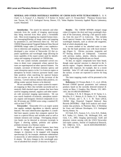
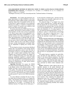
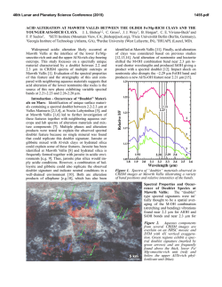
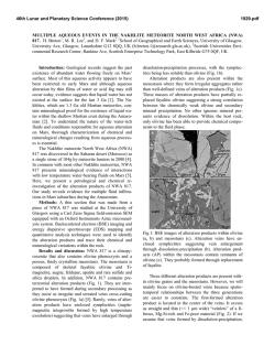
46th Lunar and Planetary Science Conference (2015)
1738.pdf
DIVERSE MORPHOLOGY AND MINERALOGY OF AQUEOUS OUTCROPS AT LIBYA MONTES,
MARS D. Tirsch1, J. L. Bishop1,2, J. Voigt1,3, L. L. Tornabene4, G. Erkeling5, H. Hiesinger5 and R. Jaumann1,3
1
Institute of Planetary Research, German Aerospace Center (DLR), Berlin, Germany, [email protected]. 2Carl
Sagan Center, SETI Institute, Mountain View, CA, USA.3Institute of Geological Sciences, Freie Universität Berlin,
Berlin, Germany. 4Dept. of Earth Sciences, Centre for Planetary Science and Exploration, University of Western
Ontario, London, Canada. 5Institut für Planetologie, Westfälische Wilhelms-Universität Münster, Germany.
Introduction: The Libya Montes are part of
the southern rim-complex of the Isidis impact basin on
Mars. The region is characterized by pre-Noachian and
Noachian aged highland rocks alternating with multiple
sedimentary units of Noachian to Amazonian age,
some of them heavily dissected by dense valley
networks [1 - 7]. The region experienced a complex
history of impact, volcanic, tectonic, fluvial and
aeolian modification processes resulting in the geology
observed today. Ancient aqueous outcrops have been
identified by coordinated spectral and geological
analyses at various locations in the region [7]. The
study site is centered at 85.4° E and 3.5° S and
comprises most geological units and morphological
expressions of surface-forming processes that are
typical for the wider region. Our results reveal clues
about the geological history of the study site in context
with regionally acting modification processes.
Methods: We performed a photogeological
mapping, as well as morphological and spectral
analyses on a variety of datasets. HRSC topography
(50 m/px), HiRISE and CTX imagery (25 cm/px and
6 m/px), and CRISM spectral data (18/33.8 m/px) have
been used to reveal the geological setting of the region.
Specific geologic units indicated by CRISM mineral
maps derived from spectral parameter products (R:
BD2300, G: OLV, B: LCP), have been evaluated
mineralogically using the CRISM analysis tool (CAT)
in ENVI and comparison with lab spectra of known
composition. Spectral ratios were used to emphasize
absorption features of surface outcrops. Geological
mapping was performed using the mapping tools of
Figure 1: Geological map of the study site at Libya Montes as inferred from spectral and image data. Mapping basis: CRISM
mineral maps, CTX imagery and HRSC topography.
46th Lunar and Planetary Science Conference (2015)
ArcGIS and a mapping scale of 1:40.000. Geological
units are deduced from spectral and morphological
interpretation of the spectral and image data. Hence,
morphological units are associated with their major
mineralogical compounds. Areas lacking CRISM
coverage have been interpreted solely on the basis of
their morphological expression. Their mineralogy was
assigned by careful extrapolation from nearby units of
similar morphology/texture and known mineralogical
information from CRISM.
Results and Discussion: The geological history
of the region as revealed by the analysis comprises an
emplacement of olivine-rich lava onto ancient basaltic
bedrock, which was later covered by pyroxene-rich
caprock (Fig. 1). This latter extended top unit might
either represent lava layers, presumably originating
from the Syrtis Major province [1], or indurated mud
flows emplaced by mud volcanism [8]. Smaller
outcrops of phyllosilicate-rich materials are located
where subsurface facies are exposed to the surfaces,
e.g., at the central peak of Hashir crater (Fig. 2a), at
areas of high erosion, or within the walls of Duvolo
crater (Fig. 1). These outcrops are enriched in Fe-/Mgphyllosilicates and have a hummocky texture (Fig. 2
a,b,e). We suggest that these minerals result from the
partial alteration of the ancient bedrock through
hydrothermal alteration (presumably triggered by the
Isidis impact) and/or later by hydrous alteration caused
by fluvial activity. Aeolian and fluvial activity led to
extensive erosion of the mantling geological units,
likewise supporting the excavation of the clays. Fluviolacustrine processes also led to the deposition of deltaic
deposits and an alluvial fan (Fig. 1). Layered Al-rich
smectites, beidellite in this case, have been detected in
the delta body (Fig. 2d, cf. [9]). In the western part of
the study region, massif units enriched in Al-smectites
have also been detected at the flanks of the ancient
bedrock (Fig. 2c), indicating that they might be the
result of aqueous alteration of the pyroxene-bearing
bedrock and/or caprock, occurring a long time after the
formation of the Fe/Mg-clays. We also observe
carbonate-bearing outcrops in two spots of the study
region: In the western part, these carbonates are
intermixed with Fe-/Mg-smectites (Fig. 2e) and in the
eastern part they are exposed at some small outcrops
along eroded highland flanks (Fig. 2f). These
detections suggest aqueous alteration that is associated
with Mg-/Fe-rich fluids under a CO2-rich atmosphere
[10]. The variability in phyllosilicates and the presence
of carbonates imply a changing alteration environment.
Acknowledgements: We thank the MRO and
Mars Express teams for successful planning and
acquisition of the data and NASA’s PGG program for
support of the project.
1738.pdf
Figure 2: Morphology of different phyllosilicate-rich
outcrops at Libya Montes reflecting a heterogeneous
formation history (CTX close-ups).
References:
[1] Tornabene, L. L. et al. (2008) JGR 113, doi:
10.1029/2007JE002988. [2] Scott D. H. & Tanaka K.
L. (1986) USGS map# I-1802-A. [3] Crumpler, L. S. &
Tanaka,
K.
L.
(2003)
JGR,
108,
doi:
10.1029/2002JE002040. [4] Jaumann, R. et al. (2010)
EPSL 294, 272-290. [5] Erkeling et al. (2010) EPSL
294, 291-305. [6] Tanaka K. L. et al. (2014) USGS
SIM 3292. [7] Bishop, J. L. et al. (2013) JGR, 118,
487-513. [8] Ivanov, M. A. et al. (2014) Icarus 228,
121-140. [9] Erkeling et al. (2012) Icarus 219, 393413. [10] Niles, P. B. et al. (2013) Space Sci. Rev.,
174, 301-328.

© Copyright 2026