
Mechanical Effects of Clay Sediment Layers on - USRA
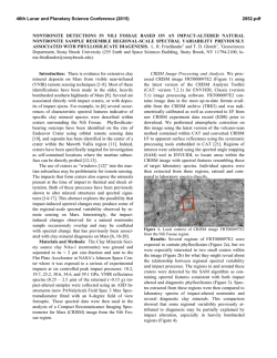
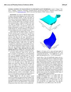
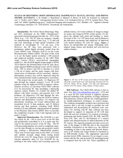
46th Lunar and Planetary Science Conference (2015)
2539.pdf
MECHANICAL EFFECTS OF CLAY SEDIMENT LAYERS ON LANDSLIDES AND FAULT SYSTEMS,
AT LARGE VOLCANOES AND ELSEWHERE ON MARS. P. J. McGovern1, and J. L. Hero2, 1Lunar and
Planetary Institute, USRA, 3600 Bay Area Blvd., Houston, TX 77058 ([email protected]). 2Department of
Earth Science, Rice University, MS-126, 6100 Main Street, Houston, TX, 77005.
Introduction: In the past decade, detections of the
spectral signatures of phyllosilicate (clay) minerals in
ancient terrains [1-2] have transformed our understanding of the geochemical and hydrothermal evolution of
Mars. Phyllosilicates are inferred to have been widely
generated during a period of time that overlaps with
the Noachian epoch. As this period also coincides with
a maximum in inferred hydrological and erosive activity, it is plausible that transport of phyllosilicates would
lead to deposition of clay-based sediments in relatively
low-lying areas. Elsewhere, we have described the
potential for extensive clay sediment layers (via generation of high pore fluid pressures) for enabling volcanic spreading and flank failure at large edifices [3-6]
and generating wrinkle ridge and thrust belt fault systems [7]. Here, we focus on two findings. First, we
present CRISM spectral evidence for exposures of clay
minerals in the Olympus Mons aureole lobes and east
flank wrinkle ridge (thrust fault) system, allowing inference of a buried clay sediment layer. Second, we
outline several consequences of basal clay sediments
for flank failure at large edifices like Olympus Mons:
deformation at both gradual and catastrophic timescales, producing edifice margin slumping [6] and aureole lobe-creating landslides [3, 8], respectively.
CRISM Images: CRISM is an imaging spectrometer that senses wavelengths between 362 and 3920 nm
[9], including both the visible range and the near infrared. At infrared wavelengths, CRISM can detect water
incorporated into minerals, such as phyllosilicates.
Phyllosilicate signatures east of Olympus Mons (Fig.
1) outline the system of wrinkle ridges at the foot of
the edifice [6], indicating an association with tectonism
that exposes buried deposits or layers. Phyllosilicates
are also detected in several other locations around
Olympus Mons, including lobes of the aureoles
(25.98N, 225.33E) and at fracture systems in the flexural moat (16.03N 232.93E) The former detection occurs at the edges of an overturned aureole block, as
might be expected if layers within the block [e.g., 3]
consist of a substantial fraction of clays.
Discussion: The detection of phyllosilicate signatures at the foot of Olympus Mons edifice and in the
aureole has important implications for the nature of the
basement and for the mechanics of volcanic spreading
and aureole lobe formation (giant landsliding).
Basement. The idea that basal sediments could be
involved in the deformation of Olympus Mons and its
aureoles has a long history: [10] proposed that the aureoles were thrust sheets in bedded sediments squeezed
out from under the weight of the edifice, and proposed
an analogy with gravity sliding in the Bearpaw
Moutntains of Montana on a basal bentonite (clay)
layer. Subsequent work focused on a basal decollement
type model [e.g., 3-5, 8], inspired by the mode of flank
spreading at the Hawaiian Islands [e.g., 11]. Pore fluid
overpressure, generated by the weight of the growing
edifice and facilitated by the low hydraulic diffusivity
of clays [e.g., 12], allows a basal clay sediment layer to
act as a decollement. The detection of clays on the
eastern Olympus Mons wrinkle ridge system (Fig. 1)
supports the interpretation of this system as the surface
expression of a thrust fault system that connects to a
basal decollement sediment layer [6].
Spreading and Landsliding. The role of basal sediments in facilitating edifice spreading has been outlined previously [3-7]. Edifice spreading and flank
collapse are intimately linked: outward motion of volcano flanks generates failure mechanisms that are both
gradual (“slumps”) and catastrophic (“slides”) [13].
The Olympus Mons aureole lobes (or “deposits”) have
long been considered as potential edifice-derived landslides [14], and this interpretation has been strengthened by high-resolution imaging and topography data
from missions in the last 15 years [e.g., 3-6]. The aureole lobes, interpreted as long-runout landslides, have
extraordinarily low ratios of original height H to
runout length L, requiring very low effective friction µ
on the basal slide surface. A clay-based, overpressured
decollement, could reduce effective friction to the required level. The detection of clay outcrops in the
jumbled blocks of the Olympus Mons aureole supports
this hypothesis: the outcrops represent the basal sediment layer, and are exposed via overturn of the aureole
blocks during the (catastrophic) emplacement process.
The presence of clays has also been invoked as a
facilitator of long-runout landslides in Valles Marineris
(VM) [15]. These workers detected a correlation between landslide transport distance, lateral spreading,
and the presence of hydrated silicates. They proposed
that water absorption reduced the phyllosilicate friction
coefficient by a factor of three relative to that of dry
rocks. They suggested that the landslides overran hydrated clay-bearing deposits on the floors of the VM
troughs, facilitating the long runout distances. The
46th Lunar and Planetary Science Conference (2015)
origin of the proposed trough-floor-covering phyllosilicates is unclear. While phyllosilicate generation on
Mars may have continued into the Hesperian [15], it
was most vigorous in the Noachian epoch, well before
the formation of Valles Marineris troughs in the Hesperian. Thus, it is unlikely that the phyllosilicates
formed in situ. They may be eroding out of the wall
rock, but unless a pre-existing concentration of phyllosilicates is being eroded, the means of accumulating a
sufficient concentration to allow enhanced sliding is
unresolved. However, [5] suggested that a clay sediment horizon beneath Solis and Lunae Plana (adjacent
to VM) facilitated the formation of the wrinkle ridges
covering those regions in a thin-skinned mode of formation. Erosion of such a horizon where exposed in
the VM scarp would provide a concentrated source of
phyllosilicates for the proposed VM landslide enhancement [15], and perhaps help to nucleate the slides
themselves. A combination of spectral image analysis
and structural interpretations of the failed trough margins could test this idea.
2539.pdf
References: [1] F. Poulet et al. (2005) Nature, 438,
623. [2] J.-P. Bibring et al. (2006) Science, 312, 400.
[3] P. J. McGovern et al. (2004) JGR, 107, doi10.1029/
2004JE002258. [4] J. K. Morgan and P. J. McGovern
(2005) JGR, doi: 10.1029/2004JB003252. [5] P. J.
McGovern and J. K. Morgan (2009) Geology, 37, 139.
[6] M. B. Weller et al. (2014) JGR, 119,
doi:10.1002/2013JE004524. [7] P. J. McGovern and J.
K. Morgan (2009), Workshop on Modeling Martian
Hydrous Environments, Abstract #4037. [8] P. J.
McGovern and S. C. Solomon (1993) JGR, 98, 23,553.
[9] Pelkey et al. (2007) JGR, 112, doi:
10.1029/2006JE002831. [10] S. A. Harris (1977) JGR,
82, 3099. [11] R. P. Denlinger and P. Okubo (1995)
JGR, 100, 24,499. [12] R. M. Iverson (1995) JVGR,
66, 295. [13] J. G. Moore et al. (1995) JGR, 94,
17,465. [14] R. M. Lopes et al. (1982) JGR, 87, 9917.
[15] J. Watkins et al. (2014), AGU Fall Mtg., Paper
P33A-4025.
Figure 1. CRISM [9] image products (observation ID 00011261) for a segment of the wrinkle ridge system at the
base of the eastern flank of Olympus Mons [6], courtesy of NASA/Johns Hopkins University Applied Physics Laboratory. (a, left) The “ir_phy” data product describing hydroxylated silicates: red (wavelength 2300nm) corresponds to Fe/Mg phyllosilicate, green (2210 nm) to Al phyllosilicate or hydrated glass, and blue (1900 nm) to hydrated sulfates, clays, glass, or water ice. (b, right) The “vnir” false-color RGB image constructed from wavelengths
590, 530, and 440 nm, respectively.
© Copyright 2026