
215 km Morokweng Impact Structure, South Africa
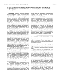
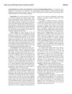
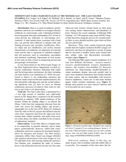
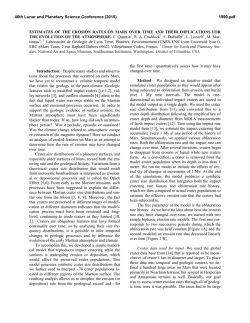
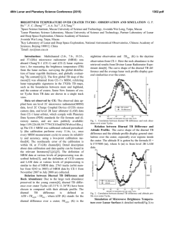
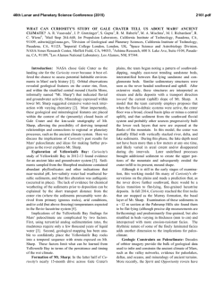
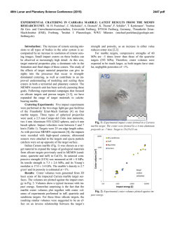
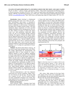
46th Lunar and Planetary Science Conference (2015)
1739.pdf
THE ~215 km MOROKWENG IMPACT STRUCTURE, SOUTH AFRICA-AN INTEGRATED SURVEY
FROM SATELLITE IMAGERY. Z. A. Botes1, S. Misra1 and M. A. G. Andreoli2,3, 1SAEES, University of
KwaZulu-Natal, Durban- 4000, South Africa ([email protected]; [email protected]), 2School of Geosciences,
University of Witwatersrand, Wits-2050, South Africa, 3Necsa, Pretoria-0001, South Africa
([email protected]).
Introduction: The Morokweng impact crater
situated in the North West Province of South Africa
was formed ~145±2 Ma ago, i.e. close to the JurassicCretaceous (J-K) boundary, by an impact of LL-6
chondrite [1-5]. The target rocks are mostly Archaean
granitoids with scattered occurrences of Archaean
meta-volcanics (ca. 3.0 to 2.9 Ga) and Proterozoic
metasediments (quartzite, carbonates and banded iron
formation) of the overlying Griqualand West
Supergroup [6].
At present, the structure is mostly buried beneath
the <70 Ma Kalahari Group of continental sediments
and calcrete; consequently, debate remains about its
actual diameter [6]. Estimates based on geophysical
interpretations range from ~340 km [7] to ~70 km [8,
9]. Our preliminary observation on the Landsat 1
imagery suggests that the diameter of this crater could
be between 160 and 200 km [10]. The J-K boundary
represents a period of geological upheavals and
environmental disruption including large meteorite
impacts, important sub-marine volcanism and climatic
changes [11]. Therefore, better information on the
actual size and other impact-related structures of the
Morokweng crater (e.g. radial, faults and dykes) is
important for evaluating the relationship between large
impacts and possible terrestrial catastrophe. In the
present work, we therefore present some important
features observed in the satellite images of the
Morokweng crater.
Satellite imagery: Our preliminary Inspection of
the Landsat satellite imagery showed that Landsat-1
(previously Earth Resources Technology Satellite ERTS) provided the best contrast from its Band 1
(Green, 500-600 nm) Multi-spectral Scanner (MSS)
(Fig. 1). Available imagery dated from 1973 with two
frames infilled from 1979 and 1980. The panchromatic
images were interpreted in conjunction with a 100 x
100 m DEM. We have also attempted to evaluate the
dimension and structure of the Morokweng crater
using the radar images provided by Alaska Satellite
Facility. However, these images cannot be fruitfully
used for this crater due to their low level of
penetration.
Morphology of Morokweng crater: The area of
the Morokweng crater generally has low relief (mean
1224m AMSL) with minimum and maximum elevations of 1019 and 1520m AMSL, respectively (Fig. 1).
The crater consists of higher ground in the SE half and
lower ground in the NW half of the area. The segments
of semi-circular ridges (5-8 km wide) rising 150-200 m
above the surrounding topography, with a probable
geographic center at 26o40/07//S, 23o58/54//E, mark the
maximum visible extension of the structure.
Extrapolating the semi-circular ridges to a circle
(yellow dashed circle in Fig. 1) we find a diameter of
the structure to be around 215 km, encompassing an
area of ~32,000 km2.
Within this circular structure, there is also another
circular feature (black dashed line) which could be
concentric with the bigger circular feature even though
its center appears marginally displaced towards NW
relative to the center of the larger circular feature.
Some lineations have also been identified along the
periphery of the inner structure, two subparallel to the
structure and one perpendicular. Note that the centre of
both rings lies 30 – 40 km ESE of the centre of the
impact melt sheet.
Fig. 1. False colour Landsat-1 satellite image of Morokweng crater showing the present extension of the crater
(yellow dashed circle) and development of concentric ring
like structures within the crater (black dashed circle).Red
dot: approximate centre of impact melt sheet [1, 2, 3, 7, 8, 9]
We have also examined the variation of elevations
along the cross sections AA/ and BB/ of the inferred
circular feature (Fig. 2, 3). The central part of the ring
is always found to have higher elevation by ~ 1.25
times of its present margin.
46th Lunar and Planetary Science Conference (2015)
The river system presently existing in this terrain
has originated from the central highland of the
structure and is mainly flowing towards NW along
sub-parallel channels flowing in the SE-NW direction
(Fig. 4). A few channels also flowing towards south
from the central highland of the structure.
Fig. 2. Shaded DEM of Morokweng crater showing
present topographic elevation of the structure.
1739.pdf
proterozoic supracrustal rocks of the Griqualand West
Supergroup. An integrated study on the magnetic,
gravity and borehole data [13] indicated the presence
of 5 concentric rings with an outermost diameter of
240 km for this crater. Our study confirms that this
structure has a minimum diameter of 215 km at
present, and represents one of the largest terrestrial
impact craters. Finally, the eccentric position of the
well-studied Morokweng impact melt sheet [1, 2, 3. 7,
8, 9, 13] relative to the Landsat rings may be the result
of a post-impact structural rebound [13].
Fig. 4. Landsat-1 Band 1 satellite image of Morokweng crater showing the distribution of present
drainage system.
References: [1] Andreoli M.A.G. et al. (1995) in Centennial
Fig. 3. Cross-sections A-A’ and B-B’ as indicated on
Figure 2.
Discussion: Our detailed analysis of the Landsat-1
satellite image reveals a number of arc segments
consistent with and improves on previous observations
made on different sets of Landsat images [10, 13].
Accordingly, the Morokweng area appears as a light
coloured, sub circular region rimmed by a segmented,
incomplete arc of dark coloured outcrops of Palaeo-
Geocongress, Johannesburg, 541-544. [2] Hart R. J. et al. (1997)
Earth Planet. Sci. Lett., 147, 25-35. [3] Koeberl C. et al. (1997)
Geology, 25, 731-734. [4] McDonald I. et al. (2001) Geochim.
Cosmochim. Acta, 65, 299-309. [5] Maier W. D. et al. (2006) Nature,
441, 203-206. [6] Koeberl C. and Reimold W. U. (2003) Geochim.
Cosmochim. Acta, 67, 1837-1862. [7] Corner B. et al. (1997) Earth
Planet. Sci. Lett., 146, 351-364. [8] Henkel H. et al. (2002) J. Appl.
Geophys., 49, 129-147. [9] Reimold W. U. et al. (2002) Earth
Planet. Sci. Lett., 221-232. [10] Townsend C. et al. (2011) 74th MSM,
abs. no. 5523. [11] Misra S. et al. (2014) 45th LPSC, abs. no. 1017.
[12] Misra S. et al. (2011) 42nd LPSC, abs. No. 1102. [13] Andreoli
M.A.G. et al. (2007) 10th SAGA Biennial Meeting, 4 pp.
© Copyright 2026