Science Objectives of the SuperCam Instrument for the Mars2020
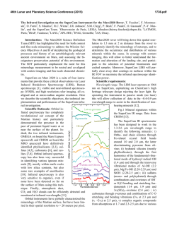
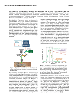
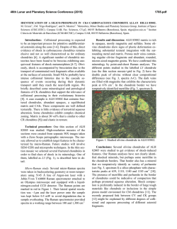
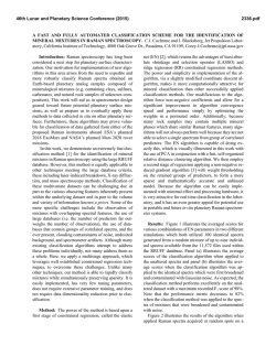
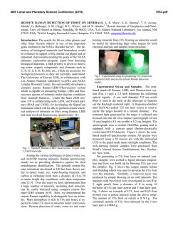
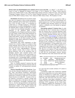
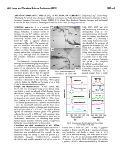
46th Lunar and Planetary Science Conference (2015) 2818.pdf Science Objectives of the SuperCam Instrument for the Mars2020 Rover. S. Maurice1, R.C. Wiens2, R. Anderson3, O. Beyssac4, L. Bonal5, S. Clegg2, L. DeFlores6, G. Dromart7, W. Fischer8, O. Forni1, O. Gasnault1, J. Grotzinger8, J. Johnson9, J. Martinez-Frias17, N. Mangold11, S. McLennan12, F. Montmessin13, F. Rull10, S. Sharma14, T. Fouchet15, F. Poulet16, and the SuperCam** team. 1IRAP, Toulouse, France ([email protected]); 2LANL, Los Alamos; 3USGS, Flagstaff, AZ; 4IMPMC, Paris; 5IPAG, Grenoble; 6JPL, Pasadena; 7LGLTPE, Lyon; 8Caltech, Pasadena; 9APL/JHU, Laurel; 10UVA-CSIC, Valladolid; 11LPGN, Nantes; 12S. Brook Univ.; 13LATMOS, Guyancourt; 14HIGP, Hawai’I, 15LESIA, Meudon; 16IAS, Orsay; 17 CSIC-UCM, Madrid. Introduction. Microscale characterization of the mineralogy and elemental chemistry of the Martian surface, along with the search for extant organic materials, are fundamental investigations that lay the groundwork for all types of Mars geochemistry and astrobiology investigations. SuperCam, onboard the Mars2020 rover, is a suite of four co-aligned instruments that remotely provide these critical observations via Laser Induced Breakdown Spectroscopy (LIBS), Raman spectroscopy, time-resolved fluorescence (TRF), visible and near-infrared spectroscopy (VISIR), and high resolution color remote micro-imaging (RMI). The LIBS, VIS, and RMI capabilities rely heavily on heritage from the ChemCam instrument on MSL [e.g. 1].The different investigations and their implementation (Figure 1) are described in companion abstracts: LIBS, Raman, and TRF by Clegg et al. [2], VISIR by Fouchet et al. [3], RMI by Gasnault et al. [4]. We focus here on the overall science objectives and their relationship with the mission goals, on the characteristic scale of each investigation, and on the implementation of different observation modes to account for the versatility of the instrument. 2 shows how SuperCam science objectives map with the mission goals. 1. Rock Identification: Detailed mineral, chemical and textural characterization of rocks will help to determine the geological diversity of the site, to identify key processes relevant to its aqueous history, and to document the context of the sample cache. 2. Sedimentology and Stratigraphy: Characterization of the texture and composition of the sedimentary structures will provide strong constraints for the aqueous processes as well as its potential habitability. 3. Organics and Bio-signatures: SuperCam will analyze astrobiologically relevant materials without requiring contact, determining the best area for contact science and caching, and will allow interrogation of areas inaccessible to the rover arm. 4. Volatiles: SuperCam will constrain the aqueous processes involving volatiles and provide data on volatile content for the documentation of cached material. 5. Context Morphology and Texture: High resolution color images will provide detailed information on dust covering, target morphology and texture. 6. Coatings and Varnishes: Analyses of coatings will allow the identification of late-stage weathering and its relationship (if any) to biological activity. 7. Regolith Characterization: SuperCam will address soil diversity at the landing site and will characterize the soil potential for biosignature preservation. Additionally, LIBS detection of hazardous elements in dust will provide important data for human exploration. 8. Atmospheric Characterization: Atmospheric molecules, water ice, and dust characteristics will address the radiative balance of the atmosphere, and will prepare for human exploration. Fig. 1. SuperCam investigations contributing together to the detection of Potential Biosignatures (PBS). Science objectives. The Science Definition Team (SDT [5]) defines four separate goals for the 2020 mission to assess whether life had developed on Mars and to assemble a returnable cache of samples. Figure Fig. 2. Science goals and their relationship with mission objectives (different shades of gray anticipate the impact of SuperCam on the various themes). 46th Lunar and Planetary Science Conference (2015) Remote Sensing and Sampling Scales. SuperCam will operate at remote distances. Each investigation has its range of distances to target, from 2 m to 7 m for LIBS, up to 12 m for Raman and TRF, up to the horizon for VISIR and RMI. In this way SuperCam will make thousands of measurements within and well beyond the arm workspace. All investigations will be co-boresighted. Additionally, each investigation has its own sampling scale. The LIBS analysis area is 300 – 600 µm in diameter. Single laser shots probe typically a few µm in depth. When operated in a depth profile mode (hundreds to a thousand laser shots), the vertical sampling can go down to ~500 µm in rocks, depending on the nature of the target. The Raman, TRF, and VISIR analysisfootprints are similar, at 0.67 mrad (1.3 mm at 2 m distance). The imaging field of view is 20 mrad and the pixel FOV is 20 µrad (40 µm at 2 m). The SDT recommended six threshold measurements including context 1) imaging and 2) mineralogy, fine-scale 3) imaging, 4) mineralogy, and 5) elemental chemistry, and 6) organic detection. SuperCam clearly meets the scale requirements (1,2) of the context measurements, though SuperCam is not the primary context camera (Mastcam-Z fills this role). With “scan mode” (see below), SuperCam can survey an area rapidly. SuperCam provides organic detection (6) on a broad survey scale using remote Raman, fluorescence, and VISIR spectroscopy. Regarding fine-scale observations (3,4,5), SuperCam meets or approaches the SDT resolution criteria at close range. We expect armmounted instruments (PiXL, SHERLOC) to fulfill the fine-scale requirements. 2818.pdf modes of investigations are being defined to acquire context and very fine scale chemical and mineralogical data (Figure 3). Survey raster, a combination of single points to study lateral heterogeneity and chemostratigraphy. This involves the full suite of investigations within 7 m; Raman up to 12 m, and VISIR to greater distances. Depth profile, a unique capability of LIBS to probe the first 10 – 500 microns below the surface. Scan mode, 30° exploration in azimuth at close range (Raman + VISIR) and longer range (VISIR) (. While the mast is rotated at its slowest speed, Raman and/or VISIR spectra are acquired continuously. Fine scale Mode, targeted pointing at < 7 m for full chemistry and mineralogy investigations. Using JPL onboard software AEGIS [6] laser shots can be autotargeted at very small (e.g., mm or sub-mm) objects of interests (veins, nodules, laminae, etc.) Depending on the mission phase, we anticipate various usage levels of these modes: “scan” and “raster” modes being predominantly used when approaching a region-of-interest, “fine scale” and “depth profile” modes being used to select and document sample caching. Based on that reasoning, we have built a model that weights the probability for each observation mode to obtain a “reference sol on Mars,” which contains 11 LIBS, 8 Raman, and 16 VISIR points, plus 10 images per sol. Of the Raman spectra, at least one is time-resolved fluorescence. For comparison, ChemCam/MSL (activated 50% of time during the first 850 sols) has performed on average 13 LIBS points and 8 images per sol. Management. SuperCam is a multinational instrument. The US contribution is funded by NASA. R. Wiens at Los Alamos National Laboratory (LANL) is the instrument PI. The French contribution is funded by CNES. S. Maurice at the Institut de Recherche en Astrophysique et Planétologie (IRAP) is the instrument deputy-PI. Spain under the leadership of F. Rull at the University of Valladolid (UVA) will be responsible of the instrument calibration targets. ** Other collaborators of the SuperCam team in France are: P.-Y. Meslin, J. Lasue, S. Le Mouélic, O. Grasset, P. Beck, E. Lewin, K. Benzerara, V. Sautter, S. Bernard, G. Montagnac, C. Fabre, B. Bousquet, and P. Paillou. Fig. 3: Observation modes of the SuperCam instrument. Obervation modes. To account for the diversity of the situations encountered by a rover (Traverse & Approach; Site study; Arm & Contact science) and the versatility of the instrument (several investigations, different remote sensing ranges and spot sizes), several References: [1] Anderson R. et al. (2014) ChemCam Results from the Shaler Outcrop in Gale Crater, Mars, Icarus (in press). [2] Clegg S. M. et al. (2015) LPSC XLVI, this issue. [3] Fouchet T. et al. (2015) LPSC XLVI, this issue. [4] Gasnault O. et al. (2015) LPSC XLVI, this issue. [5] Mustard J. et al. (2013): Report of the Mars 2020 Science Definition Team. [6] Estlin T. et al. (2013) Fall AGU Meeting, abstract #P51G-1801.
© Copyright 2026
