
generation of ultrahigh spatial resolution digital terrain models for a
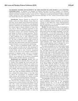
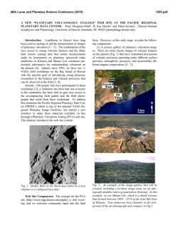
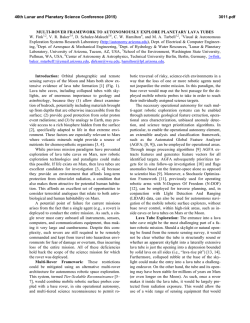
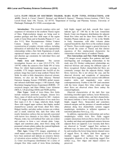
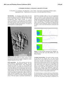
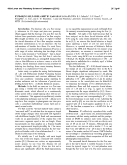
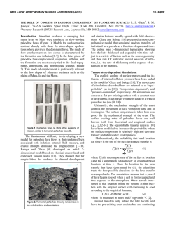
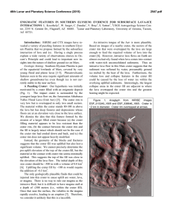
46th Lunar and Planetary Science Conference (2015)
1055.pdf
GENERATION OF ULTRAHIGH SPATIAL RESOLUTION DIGITAL TERRAIN MODELS FOR A
MARTAIN LAVA FLOW ANALOG FROM KILAUEA VOLCANO, HAWAII. S. P. Scheidt1 and C. W.
Hamilton, 1Lunar and Planetary Laboratory, University of Arizona, 1629 E University Blvd, Tucson, AZ 85721
([email protected]).
Introduction: Sinuous channels are common on
the surface of many planets and moons, but on the
Earth and Mars, these channels may either have been
formed by fluvial or volcanic processes. Distinguishing
between these formation mechanisms is therefore critical for correctly interpreting their origin and geological
significance. The December 31, 1974, lava flow from
Kīlauea Caldera, Hawai`i, exhibits fluvial‐like morphologies, and was selected as a locale for field campaigns as a terrestrial analog for volcanic sinuous
channels on Mars, such as those located within the
Cerberus Fossae 2 unit in Elysium Planitia. The sheetlike lava flow [1] was rapidly emplaced [2, 3, 4] from a
series of en echelon fissures southwest of Kīlauea Caldera. The resulting flow thickness is ~1-m-thick in the
proximal regions and transition to much thicker channelized `a`ā flows ~2 km from the vent [1].
Topographic data of the flow were needed to test
the hypothesis that sinuous channels can form by lava
flow emplacement processes involving an initial constructional stage, followed by lava drainage; and to
make direct comparisons with morphological and
topographic features observed in Mars Reconnaissance
Obiter (MRO) High Resolution Imaging Science Experiment (HiRISE) imagery and stereo-derived Digital
Terrain Models (DTMs). Here, we describe preliminary results obtained using Multi-View StereoPhotogrammetry (MVSP) techniques applied to aerial
photographs acquired from a kite-based platform.
Methods: Digital phototographs were aquired during the Summer of 2014 for a 0.5 km2 region of the
December 1974 flow using low-altitude, Kite Aerial
Photography (KAP) methods in the Hawai`i Volcanoes
National Park (supported by NASA Planetary Geology
and Geophysics grant NNX13AQ05G, under the authorization of National Park Service permit #HAVO-
2012-SCI-0025). The KAP technique allowed the capture of high-resolution images at low cost from a
unique aerial vantage point. These images where then
used to produce contiguous orthographic images and
topographic data for the lava flow surface. Incidence
angles (θ) were 0° ± 10° for images collected using a
Canon Powershot S110 loaded with a firmware script
to capture 12 megapixel images automatically every 3
seconds in flight from a customized KAP platform. A
second camera (Pentax Optio-WG2 with geotagging)
was mounted on a platform with an automatically rotating servomotor and infrared shutter release to acquire off-nadir images (9 megapixels) every 5 seconds
(θ < 20° ± 10°). KAP rigs were attached to the kite line
approximately 10 m below the kite using a Picavet
suspension system. Coverage of the area was accomplished by hiking across the lava flow during eight
separate flights. The images were then used as input
for a custom MVSP processing workflow based on [5,
6]. This software simultaneously calculates the aerial
positions of the camera for each image, refines interior
and exterior camera orientation parameters, and generates a 3-Dimensional (3D) point cloud of the surface
(Fig. 1). In general, feature detection and matching of
multiple overlapping images results in a unique solution of 3D tie points. A dense reconstruction of the
scene is then processed from the sparse tie points [e.g.,
6] and post-processing (e.g., statistical outlier removal
and smoothing) are applied to create color-textured,
georeferenced orthoimages and DTMs. Black and
white ground targets (1.3 × 1.3 m) were placed
throughout the lava flow surface, geolocated with differential GPS, and used for geolocation of the 3D data.
Results: The preliminary 3D model covers approximately 5 × 10⁶ m2 and contains 5 × 10⁸ points, resulting in a grid resolution of < 2 cm.
Figure. 1. The image shows two rendered 3D point clouds seen from an oblique view. The upper cloud shows positions of 11,649 aerial images captured by a camera lofted by a kite. The lower portion represent a half billion topographic points calculated using MVSP of the December 1974 flow on Kīlauea Volcano, Hawai`i.
46th Lunar and Planetary Science Conference (2015)
1055.pdf
matched image pixels (Fig. 3B). Figure 3 also shows
other features of interest, such as older lava units exposed along the northern flow margin, and a prominent
fault scarp of Kīlauea’s Southwest Rift Zone, which
confines the southern margin of the December 1974
flow. Data are sparse along the edge of the point cloud
and in low-texture areas (e.g., sand) where the MVSP
algorithms could extract little to no information.
Subsequent data processing will generate
orthoimages and merge the dense 3D point clouds with
ground-based photometric data and Light Detection
and Ranging (LiDAR) measurements to enable detailed facies mapping and terrain analysis in ArcGIS.
Figure 2. Rendered 3D point clouds (10 × 10 m area, 3
mm resolution) exhibit varied flow surface textures.
The color overlay illustrates the maximum elevation
difference within the colored region (z) for five transitional surface textures: (A) smooth platy pāhoehoe, (B)
a lava spreading zone, (C) rubbly pāhoehoe, (D) slabby
pāhoehoe, and (E) and overbank flows.
Highly oblique images (θ ≈ 60°) provide a synoptic view of the flow (Fig. 3A). Dark- and light-albedo
areas highlight rafted lava slabs and plates, sinuous
channels, and streamlined islands. Islands with a tan
color are high-standing outcrops (kīpuka) composed of
older lava flows, which contrast starkly with the silvergray and black December 1974 lava [8]. Vertices in the
3D point cloud are rendered with the average color of
Figure 3. (A) Oblique aerial image of the study area
within the December 1974 flow, facing southsouthwest.(B) 3D point cloud viewed from nadir.
References: [1] Lockwood J.P. et al. (1999) USGS
Prof. Pap., 1613, 37 pp. [2] Decker R.W. and Christiansen R.L. (1984) Explosive eruptions of Kilauea Volcano, Hawaii, NRC, 122–132. [3] McPhie J. et al.
(1990) Bull. Volcanol., 52, 334–354. [3] Swanson
D.A. (2003) Cities on Volcanoes, 3, 125. [4] Soule
S.A. et al. (2004) Bull. Volcanol., 66, 1–14. [5] Wu C.
(2013), Int. Conf. 3DV, doi:10.1109/3DV.2013.25. [6]
Furukawa Y. and Ponce J. (2010) IEEE Trans. Pattern
Anal. Mach. Intell., 32, 8, 1362–1376. [7] Gaddis L.R.
et al. (1989) Geol. Soc. Am. Bull., 101, 317–332. [8]
Holcomb R.T. (1987) USGS Volcanism in Hawaii.
Prof. Pap., 1350, 261–350.
© Copyright 2026