
GEOLOGIC MAP OF THE 1:10M APHRODITE MAP AREA, VENUS
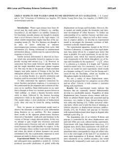
46th Lunar and Planetary Science Conference (2015)
1888.pdf
GEOLOGIC MAP OF THE 1:10M APHRODITE MAP AREA, VENUS. V.L. Hansen1, I. López2, K.G. Thaisen1, 1University of Minnesota Duluth, Duluth, MN 55812 ([email protected]), 2Área de Geología. Universidad
Rey Juan Carlos. 28933. Mostoles. Madrid ([email protected]).
Introduction: We present the 1:10M geologic map
of the Aphrodite Map area (0-57S/60-180E, I-2476)
and briefly present the geologic history of this region.
The Aphrodite Map Area (AMA) contains a rich assemblage of: local basement terrains (crustal plateaus,
lowland tessera inliers and other local basal units);
fractures zones (dense fracture zones, coronae chains
and chasmata); flows materials (shield terrain, volcano- and corona-related materials, Artemis-fed flows,
fracture-fed flows, and undivided flows); and, perhaps
most notable, the map area’s namesake, Artemis,
which lies just east of the center of the AMA. The fracture zones form three ‘arms’ that extend radially from
Artemis: the Diana-Dali arm trends to the ENE; a
broad zone of fractures and variably developed
coronae fan outward from the SW to the WNW, and
the narrowest of the three arms is comprised of a Ntrending zone of Artemis-radial fractures decorated
with coronae that trends northward into the Niobe Map
area (discussed in a companion abstract [1]).
Data and methods. Geologic mapping was carried out using: (1) NASA Magellan full-resolution
SAR data (left- and right-look; normal and inverted
modes) [2]; (2) NASA Magellan altimetry; and (3)
synthetic stereo images constructed using NIH-Image
macros developed by D.A. Young.
Data visualization and geologic mapping was conducted using Adobe Illustratortm with linked data layers, MAPublishertm to scale and georeference raster
datasets, and ArcGIStm and ArcGlobetm for compilation, projection and analysis.
Geologic mapping began with delineation of
secondary structures, with attention to structural character, orientation, patterns and temporal relations; material units are defined based on the patterns of secondary structures and the nature of radar characteristics.
Map relations determined using full-resolution data
were translated to the 1:10M map scale.
Overview of the Aphrodite Map Area. The AMA
is broadly divisible into four major geologic domains,
which spatially overlap: (1) crustal plateaus (Ovda &
western Ovda) and Thetis Regiones) and lowland inliers of ribbon tessera terrain; (2) Artemis, including
Artemis Chasma and the interior region, and a huge
radial dyke swarm and concentric wrinkle ridge suite,
12,000- and 13,000-km diameter, respectively [3,4];
(3) three ‘arms’ of variably focused extensional zones
marked by fractures and corona/chasma chains distrib-
uted in a radial fashion relative to Artemis chasmata;
and (4) the southwest quadrant of the AMA is relatively free of ribbon-tessera terrain [5] (although exposures of other basal terrains occur locally) and fracture/coronae/chasmata development; shield terrain is
extensively developed across this region, as are areas
likely buried by thin Artemis-fed flows.
Collectively the AMA records a geologic evolution
across the region, that changes in both time and space.
Domain Descriptions.
Domain 1: Ribbon tessera terrain formation, and
other basal regions mark some of the oldest crustal
exposures across the map area. These are best preserved in elevated crustal plateaus, although exposures
occur across the map area as basal windows that record
an early story of crustal evolution; The SE region of
the AMA has few exposures of ribbon-tessera terrain,
although other basal units occur locally.
Domain 2: The two suites of Artemis-centric structures—radial fractures and concentric wrinkle ridges—
are developed across the entire map area, and extend
into the Niobe map area, as noted by others [3,4].
These structures are best preserved in domain 4. In
some places Artemis radial fractures are better developed, in others, Artemis-concentric wrinkle ridges
dominate. Regardless it is clear that these suites are
genetically related to one another and to the Artemis
superstructure. Detailed and regional map relations
both indicate that fractures began to form before wrinkle ridges, and that the fractures likely served as conduits for Artemis-fed flows, distributing flows to local
surfaces across regions far removed from Artemis’
interior region. Areas buried by these flows, as well as
regions covered by a thin cover of shield terrain [6,7]
were later deformed by the suite of Artemis-concentric
wrinkle ridges. Locally Artemis radial fractures are
buried, and in some cases reactivated as inversion
structures [e.g., 8]; locally Artemis-radial fractures are
visible as buried lineaments.
An ~5,000-km diameter topographic trough forms
concentric to Artemis chasmata. A zone of wrinkle
ridges marks the trough low, whereas radial fractures
are locally preserved in a concentric region on either
side of the trough; these relations indicate that this
trough likely formed during evolution of the Artemis
superstructure with Artemis-fed flows collecting in the
broad trough relative to the higher-standing trough
boundaries.
46th Lunar and Planetary Science Conference (2015)
Domain 3: The more focused zones of deformation, forming ‘arms’ radial to Artemis dominantly
post-date the formation of the Artemis-centric suites of
fractures and wrinkle ridges. The AMA appears to
host three different types of coronae, and some coronae
forming hybrids between these end members: (A)
coronae marked by concentric structures; (B) coronae
that display radial fractures; (C) coronae with obvious
corona-fracture-sourced flows. The radial and concentric fractures almost certainly represent dikes or conduits for magma transport; magma can remain at depth,
or be locally transferred to the surface as in the case of
coronae with surface flows. The type of coronae may
be related to local lithospheric thickness, and the ability to support volcanic edifices and surface flows [9].
We briefly describe the radial ‘arms’ of fracture/corona/chasmata zones in turn, clockwise from the
NE. The Diana-Dali arm, which sits topographically
high compared to the other zones, extends to the ENE
from Artemis to Alta Regio, which lies outside the
AMA. The Diana-Dali arm is characterized by extremely penetrative deformation across a zone ~400km wide. The Diana-Dali arm hosts the largest coronae
in the AMA, and the most intensely fractured regions
of crust. Chasmata are the deepest and best developed
here as well. All of the coronae display radial and concentric fractures, and display variable development of
volcanic flows. The coronae farthest from Artemis and
closest to Atlas display more flows; whereas fractured
crust, rather than flows, characterize coronae closer to
Artemis. Coronae developed on the edges of the fracture zone also display more prominent flows. We postulate that the lithosphere across this zone is relatively
thin across a wide belt, allowing for the formation of
large coronae with generally subsurface magmatism
[e.g., 9]. the relatively high elevation of this arm is
consistent with thin contemporary lithosphere [10].
The broad fan-shape region from ~7 o’clock to 10
o’clock includes radial zones of more concentrated
deformation, but the area collectively records deformation and corona development in a mostly distributed
fashion across this domain. Coronae represent all 3suites of coronae types noted above; in the case of radial-fracture coronae the radial fractures of individual
coronae are best developed along trends that parallel
the local orientation of Artemis-radial fractures; concentric fractures seem best developed along trends that
parallel the local trend of Artemis-radial fractures,
whereas concentric folds are best developed in trends
nearly orthogonal to the orientation of the local
Artemis-radial fractures. These relations would be
most consistent with the interpretation that these corona mark a regional suite that evolved, broadly speaking, at the same time across this domain, and in asso-
1888.pdf
ciation with, and at the tail-end, of the evolution of the,
perhaps long-lived, Artemis superstructure. Most of
the coronae within this region display corona-sourced
flows, and thus might indicate a stronger, thicker lithosphere across this region, compared to that of the Diana-Dali zone. Detailed discussion of architectural
elements of this zone is outside the limits of the current
report.
The N-trending zone marks the least obvious and
least developed of the three Artemis-radial arms. This
zone also lies mostly within the Niobe map to the
north. Coronae form along a zone tracking N-trending,
Artemis-radial fractures; coronae within this arm display obvious flows close to Artemis, where the arm
intersects with Thetis and Ovda Regiones and a region
of extensive tessera terrain; to the north, the coronae
lack obvious flows, forming tectonic rather than magmatic coronae.
A region of intense fracture development, similar
in character to the Diana-Dali zone, occurs to NW of
Artemis, marking a WNW-trend that cuts/abuts the
southern edge of Thetis and Ovda Regiones. Locally
this zone cuts the crustal plateaus, but seems to be
mostly diverted by the highlands. This region is discussed in a companion abstract [11].
Domain 4: The southwest quadrant of the AMA
preserves an area with limited basal-terrains (just
enough to provide useful boundaries), and free of focused fracture zone/coronae/chasmata development.
As a result, this area preserves an excellent record of
the spatial and temporal development of the Artemiscentric structural suites, and Artemis fed flows. The
basal units provide windows in time, locally providing
a rich, though fragmented record of surface evolution
prior to the formation of the Artemis superstructure.
Artemis-radial fractures display incredible continuity,
extending for 300-400 km; the structures are locally
buried, yet reappear along trend, either as exposed
fractures, or as veiled locally buried structures. Where
fractures are best developed wrinkle ridges do not
form, and where wrinkle ridges are best developed,
fractures are clearly buried.
References: [1] López I. & Hansen (2015) this
volume, LPSC. [2] Ford J.P. et al. (1993) JPL Publ.
93-24. [3] Hansen V.L. & López I. (2013) Abstracts of
NASA’s Mappers Meeting. [4] Hansen V.L. & Olive A.
(2010) Geol. 38, 467-470. [5] Hansen V.L. & Willis
J.J. (1998) Icarus 132, 312-343. [6] Aubele J. (1996)
LPSC 27, 49-50. [7] Hansen V.L. (2005) GSAB 117,
808-820. [8] Deshon H.R. et al. (2000) JGR 105, 69836995. [9] McGovern et al. (2014) Geol. Soc. London
Spec. Publ. 401, 19 p. [10] Rosenblatt P. & Pinet P.C.
(1994) GRL 21, 465-468. [11] Tovar et al. (2015) this
volume.
![Download [ PDF ] - journal of evolution of medical and dental sciences](http://s2.esdocs.com/store/data/000508090_1-a9a933ff37237d5430f2b15a1b23af4a-250x500.png)


© Copyright 2026