ENIGMATIC FEATURES IN SOUTHERN ELYSIUM: EVIDENCE FOR
46th Lunar and Planetary Science Conference (2015)
2547.pdf
ENIGMATIC FEATURES IN SOUTHERN ELYSIUM: EVIDENCE FOR SUBSURFACE LAVA-ICE
INTERACTIONS L. Keszthelyi1, W. Jaeger, C. Dundas1, V. Bray2, S. Sutton2, 1USGS Astrogeology Science Center, 2255 N. Gemini Dr., Flagstaff, AZ 86001. 2Lunar and Planetary Laboratory, University of Arizona, Tucson,
AZ 85721.
Introduction: HiRISE and CTX images have revealed a variety of puzzling features in southern Elysium Planitia that we propose formed by the subsurface
interaction of lava and ice. Having a single process
explain a wide variety of observations cleaves to Occam’s Principle and could lead to important new insights into the nature of shallow ground ice on Mars.
Geologic Setting. Southern Elysium Planitia is part
of the equatorial lowlands of Mars, covered by very
young flood and plains lavas [1-5]. Phreatovolcanic
features seen in the area require significant amounts of
shallow groundwater/ice even though ice is not currently stable in the near surface.
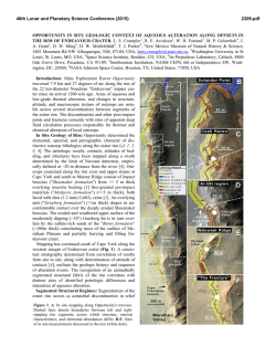
A Puzzling Crater: Our hypothesis was initially
motivated by a crater filled with an enigmatic deposit
(Fig. 1). The impact crater is surrounded by the
youngest large lava flow on, the Amazonian Athabasca
Valles Flood Lava (Unit Aav) [5]. The crater rim is
very low but is overtopped in only two small sectors.
The material within the crater stands 80-100 m above
the lava but has deep fissures and depressions whose
floors are at an elevation very close to the lava surface.
We dismiss the idea that this feature formed by the
erosion of a larger filled crater because (a) the crater
filling material appears to be less resistant than the
crater rim, (b) the contact between the crater rim and
the fill is largely intact which should not be the case if
the crater rim had eroded down and back, and (c) the
crater rim does not appear heavily modified.
Instead, the geometry of the blocks and fractures
suggests that the crater fill was uplifted but also lost a
significant volume. We cannot precisely determine the
pre-uplift elevation of the top of the crater-fill, but the
material at the contact with crater rim seems minimally
uplifted. This suggests the top of the fill was close to
the elevation of the lava flow. The initial depth of this
size crater should be ~500 m with a volume of 0.8 km3
[6]. Uplifting the crater fill by ~100 m would require
the addition of ~0.3 km3.
The only geologically plausible fluids that could be
injected into this crater to cause uplift are water, lava,
or magma. There is no way to rule out magma as the
intrusive fluid, but it is difficult to have magma stall at
a depth of ≤500 meters (i.e., within the crater fill).
Once that near the surface, the volatiles in the magma
rapidly exsolve, leading to an eruption [7]. Therefore,
we consider it unlikely that this is a laccolith.
An intrusive tongue of the Aav is more plausible.
Based on images of a nearby crater, the sectors of the
crater rim that were overtopped by the lava are large
enough to feed the required volume of lava into the
crater [8]. However, intrusive lava flows on Earth are
almost exclusively found when lava comes into contact
with water-rich unconsolidated sediments. Thus an
intrusive lava flow in this Mars crater suggests that the
sediment was softened by water, presumably ground
ice melted by the heat of the lava. Furthermore, the
volume loss and collapse features in the crater fill
could be caused by the loss of water ice within the
overlying uplifted sediments. Interestingly, the largest
collapse areas in the crater fill are adjacent to where
the lava overtopped the crater rim and the greatest
heating might be expected.
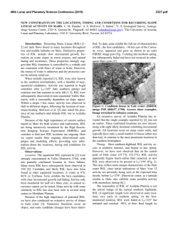
Figure 1. Anaglyph from HiRISE images
ESP_013249_1805 and ESP_038646_1805. Crater is
~2 km in diameter. Crater rim overtopped at arrows.
46th Lunar and Planetary Science Conference (2015)
It may also be possible to create this uplift with just
freezing groundwater. The heat of the Aav would raise
the temperature of the ground underneath it to above
freezing to a depth of tens to hundreds of meters [9].
Below that depth, water would freeze in the porespace,
producing an impermeable barrier preventing water
from penetrating deeper. Groundwater moving southward along the regional topographic gradient would
encounter the crater fill which would be cold because it
was not heated by lava. As the water entered the sediments and froze, it would expand. Water freezing in
pore space would not produce the observed uplift.
Instead, the gradual injection and freezing of groundwater could have created a pure-ice lens in a process
analogous to pingos on Earth.
Observations of this one crater are insufficient to
evaluate the relative merits of the “mega-pingo” and
“invasive lava” hypotheses. In either case, the feature
would be the result of subsurface lava-ice interaction.
Another Interesting Crater: Figure 2 shows a
nearby crater that exhibits a variety of features supportive of the idea of subsurface lava-ice interactions.
Figure 2. Anaglyph of
~6 km diameter crater
made from HiRISE images ESP_028387_1790
and ESP_028532_1790.
A volcanic vent with a
partially drained perched
lava pond (A) lies within
the impact crater. The
lava breached the crater
on the SE sector (C). In
this case we cannot rule
out mechanical erosion
as the dominant process.
However, there is also
significant erosion in the
NE sector, where lava
did not overflow the
crater rim (B). Here we
suggest that the heat of
the lava fountains and
lava lake melted ice in
the crater rim which produced subsurface water
flow through the ejecta.
The uplift labeled (D) in Figure 2 is especially interesting. The thickness of the uplifted block is much
greater than would be expected for the upper crust of a
lava flow, ruling out lava inflation as the formation
2547.pdf
mechanism. In fact, the HiRISE images show a thin
resistant cap on the block with much less consolidated
material underneath, possibly crater-filling sediments.
This observation requires the uplift at (D) to have
formed after the lava flow solidified. This timing is
what would be expected if the uplift were caused by
groundwater freezing after the ground returned to its
normal subfreezing temperature. It is impossible to
determine with certainty why groundwater would preferentially accumulate under this location, but a buried
impact crater is one plausible explanation.
Discussion: There are many other observations in
this region suggestive of subsurface lava-ice interactions. These include (a) scarps that appear to have
formed by sapping at the contact between lava and
older (presumably ice-rich) regolith, (b) kilometer
scale uplifts of lava and mantling deposits that may
have formed by either the “mega-pingo” or “invasive
lava” processes, and (c) lava-filled craters without obvious vents within them or breaches in the crater rim.
One possible explanation for these puzzling features is
that invasive lava penetrated through the crater rim and
filled the crater.
The source of the ground ice remains uncertain. It
is possible that the flood lavas were emplaced during
(or shortly after) large obliquity excursions, when
models suggest atmospheric implantation of ice is possible [10]. It is even possible that there was significant
snow/ice on the surface and that the Aav eruption was
subice, generating jokulhuaps. Alternatively, the water
may have been directly associated with the volcanic
eruptions. This could be as precipitation out of the
eruption column [11] or expulsion of deep water when
the cryosphere is ruptured by rising magma [12]. The
latter possibility is especially interesting since it means
these locations could preserve indicators of the nature
of Mars’ deep crustal aquifers, a possible extant habitable environment. What is certain is that these features
will engender debate for years to come.
References: [1] Tanaka K. et al. (2014) USGS Sci.
Inv. Map, 3292. [2] Vaucher J. et al. (2009) Icarus,
204, 418-442. [3] Plescia J. (1990) Icarus, 88, 465490. [4] Jaeger et al. (2007) Science, 317, 1709-1711.
[5] Jaeger W. et al. (2010) Icarus, 205, 230-243. [6]
Stewart S. T. and Valiant G. J. (2006), Meteor. Planet.
Sci., 41, 1509-1537. [7] Wilson L. and Head J. W.
(1994) Rev. Geophys., 32, 221-263. [8] Hurwitz D. M.
et al. (2010) Icarus, 210, 626-634. [9] Hamilton C. et
al. (2011) J. Geophys. Res., 116, E03004. [10] Mellon
M. T. and Jakosky B. M. (1995) J. Geophys. Res., 100,
11781-11799. [11] Plescia, J. B. (1993) Icarus, 104,
20-32. [12] Head J. W. et al. (2003) Geoph. Res. Lett.,
30, 1577.
© Copyright 2026
