
2973
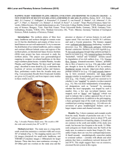
46th Lunar and Planetary Science Conference (2015)
2973.pdf
TOPOGRAPHIC ANALYSIS OF CRYOVOLCANIC STRUCTURES ON ENCELADUS AND TITAN
COMPARED TO TERRESTRIAL LANDFORMS. F. Saavedra1 1Department of Geosciences, Universidad Nacional de Colombia, Carrera 45 No 26-85 Edificio 224, Bogotá D.C., Colombia, [email protected]
Introduction: The topographic data extracted from
high resolution images can generate three-dimensional
models of small areas of Enceladus and Titan's surface
that can be compared with Earth's digital elevation
models (DEM) through GIS software. Enceladus has
landforms related cryovolcanic phenomena [1] . Titan
has a cryovolcanism that transforms its surface [2],
generating various landforms. In terrestrial high latitudes, near the arctic and antarctic regions, landforms
exist in permafrost regions where ice has significantly
altered the topography. A clear example are the 'pingos'
in northern regions of the Earth.
Methods. The topographic data generated for small
areas of Enceladus, Titan and Earth generate threedimensional models through different software and
ArcScene©, Erdas© and AutoCAD Civil©. Bearing the
three-dimensional models are compared the measurements of landforms and then are established similarities
and differences and their relation to possible formation
processes.
Basic morphometric parameters. For each landform
analyzed data were extracted elevation, slope, aspect,
vertical curvature, horizontal curvature. The slope is
important because it controls geologically surface
processes, such as cryovolcanic material flow on Titan
or the accumulation of particulate material ejected in
zones with steep elevation changes observed on the
surface of Enceladus. The orientation of landforms together give evidence of geological processes related to
its creation, while the horizontal curvature and vertical
curvature are related to the flow and dispersion of materials associated with cryovolcanic processes that exist
in the two moons of Saturn and processes volcanic on
planet Earth.
Topographic position index. For each landform
analyzed, was made an assessment of its topography
regarding the spatial context of its location in order to
relate this information to the regional geology in each
planetary body.
Results. The elevation of the structures analyzed
are close to 1 km and hundreds of meters; also, the
depressions are not below 1 km depth in selected areas.
The slopes are at Enceladus, where active tectonics
generates cliffs of centenaries of meters and cannot
relate in any way to the terrestrial pingos. These are
formed by the freezing of groundwater into a permafrost environment, but can be compared with the flow
of cryovolcanic material on the surface of Titan.
Terrestrial pingos would be the closest thing to a
cryovolcanic phenomenon on Earth, although its elevation is between 70-600 m, is not possible to compare
them with cryovolcanic landforms on Titan, for example, Sotra Patera, which has an elevation that reaches to
1500 m.
The orientation and curvature of the Earth’s pingocompared with landforms on Titan have a similarity
based on transport and remotion of material below the
freezing point of water [3], although the temperatures
in the Arctic regions of Earth and temperatures of Titan's surface are very different. The orientation and
curvature of the landforms on Enceladus’ surface can
only be compared with terrestrial landforms associated
with tectonic processes, making impossible to establish
a relationship with the pingos.
Conclusions. The topographic landforms comparison between Titan, Enceladus and Earth allows for
some similudes and differences. Terrestrial pingos and
cryovolcanic estructures at Titan are based on material
that is below the freezing point of water and abruptly
changed the local topography. The cliffs and ridges of
the topography of Enceladus are the result of tectonic
stresses in a surface showing similar rifts to those
present in the terrestrial Mid-Atlantic Ridge.
References. [1] Schenk, P. M., and J. M. Moore
(1995), Volcanic constructs on Ganymede and Enceladus: Topographic evidence from stereo images and
photoclinometry, Journal of Geophysical Research,
100 (E9), 19009–19022. [2] Radebaugh, J. (2008),
Dunes on Titan observed by Cassini Radar, Icarus,
194, 690–703. [3] Alekseyev, V.R. (2012), Cryovolcanism and the mystery of the Patom cone, Geodynamic and Tectonophysics – Institute of The Earth Crust of
SB RAS, 2, 289–307.
© Copyright 2026