
seasonal water budget suggests that a valles marineris recurring
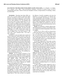
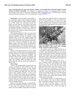
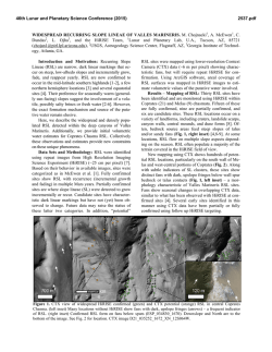
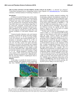
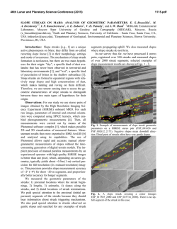
46th Lunar and Planetary Science Conference (2015) 2669.pdf SEASONAL WATER BUDGET SUGGESTS THAT A VALLES MARINERIS RECURRING SLOPE LINEAE (RSL) SITE MUST BE RECHARGED BY AN AQUIFER. D. E. Stillman1, K. L. Wagstaff2, T. I. Michaels3 and R. E. Grimm1, 1Dept. of Space Studies, Southwest Research Institute, 1050 Walnut St. #300, Boulder, CO 80302 ([email protected]), 2Jet Propulsion Laboratory, California Institute of Technology, 4800 Oak Grove Drive, Pasadena, CA 91109, 3SETI Institute, 189 Bernardo Ave Suite 100, Mountain View, CA 94043 Introduction: Recurring slope lineae (RSL) are narrow (0.5–5 m) low-albedo features that incrementally lengthen down steep slopes during warm seasons [1-3]. All RSL sites have steep slopes, outcropping bedrock, and lower albedo than average for Mars. Evidence of surficial material transport and unambiguous spectral signatures of salt [4] have not been detected. Dry and wet origins have been suggested, but waterbased hypotheses best match observations that correlate incremental lengthening with higher surface temperatures [1-3,5-8]. Over 120 candidate and confirmed RSL sites have been discovered, primarily within the southern mid-latitudes (SML), Valles Marineris (VM), and in northern Chryse Planitia and southwestern Acidalia Planitia (CAP) [8]. Some RSL sites have more than 1,000 individual RSL. Mapping each RSL at every site by hand is infeasible. Therefore, we performed computer-assisted analysis (CAA) on seven orthorectified HiRISE images to map RSL activity within a 2.4-km-wide crater (11.5S, 290.3E) on the floor of Melas Chasm in VM. We combined this result with HiRISE observations of non-orthorectified images and thermophysical modeling to obtain the first estimated water budget for an entire RSL site. We find that the water budget at this VM RSL site (during solar longitude (Ls) 133.1280.8, the water budget of Nfacing slopes is 1221 m3 per m of headwall) is higher than the previous estimation of annual water budget for SML and CAP RSL sites (210 and 24 m3/m, respectively [7,8]). We hypothesize that VM RSL sites have larger water budgets because they flow for a longer duration (~440 sols), the RSL are longer, and they have high evaporation/ sublimation rates. Computer-Assisted Analysis (CAA): We analyzed each pair of chronologically adjacent images to identify areas of RSL change (Fig. 1) and then calculated the total change in RSL area. For each pair, we normalized the pixel values by equalizing the images' mean values and then applying a local correction to compensate for variation across the image. Areas of RSL fading and lengthening were identified using image differencing. We constructed contours around each contiguous change area, and then filtered them to retain only those features that are elongated, smooth, and larger than 10 m2. We found that this approach reliably detects lengthening but sometimes misses fading, since RSL fade gradually and the changes can be subtle. Figure 1. RSL at (a) Ls 133.1 and (b) 160.7 at 11.5S, 290.3E. (c) CAA analysis showing faded and lengthening RSL. Between (a) and (b), 53 sols passed. CAA mapping can be used in many different ways to quantify the behavior of RSL. Here, we discuss the Ls and slope-orientation dependence of dark, darkened (lengthening; Fig. 2), and brightened (fading) RSL areas. We find that (1) that unlike SML and CAP RSL, 46th Lunar and Planetary Science Conference (2015) VM RSL lengthen at the same time that neighboring RSL fade (Fig. 1c). This indicates high evaporation/sublimation loss rates and source regions that quickly become depleted. (2) CAA confirms that slope orientation strongly modulates the lengthening of RSL at this site [2] (Fig. 2). Thermophysical modeling: To convert the CAAderived surface areas into volume, we estimated the amount of water within the subsurface of RSL and how much water has been lost via evaporation/sublimation. We used a 1D Mars Regional Atmospheric Modeling System (MRAMS) [3,8]. This thermophysical model includes latent heat of fusion, but not of vaporization/sublimation. We modeled different subsurface layering and melting temperatures for a slope of 32.5 at different slope orientations. A brine-saturated (253 K melting temperature) regolith 2 cm below the surface best matched the duration of flow. For NE-, N-, and NW-facing slopes this briny-layer thickness is likely only 3 cm, with the lower portion never melting and acting as an aquitard. It is assumed that this lower part does not fully sublimate away during the brief RSL inactive season. W-, SW-, and S-facing slopes must have a thicker (~8 cm) volatile-rich layer as they experience warmer temperatures that would melt through a layer 3 cm thick. Below the aquitard, a dry thermally-insulating regolith is necessary to allow heat to remain near the surface. We used the MRAMS output temperatures at the briny-layer top to compute the total evaporation/sublimation loss between subsequent images. We then computed a lower and upper bound for the volume of involved water as a function of Ls and slope orientation. The two bounds differ in their assumed subsurface porosity (30 or 60%) and when lengthening is assumed to occur between the subsequent images. The resulting lower and upper bounds of the volume of water, divided by the amount of headwall (based on the diameter of the crater) are illustrated in Figure 3. Conclusions: Orthorectified images are only available from Ls 133.1280.8 or ~40% of a martian year. However, non-orthorectified images show that Sfacing RSL lengthen around southern summer (Ls ~16030 or ~393 sols) and N-facing RSL lengthen during northern summer (Ls ~320205 or ~486 sols). Therefore, the annual water budgets of both the S- and N-facing slopes will be much larger than our approximate half-year water budgets of 212 and 1221 m3/m, respectively. The total amount of water liberated from Ls 133.1280.8 is 18,80041,800 m3 (817 Olympic sized swimming pools). The only way to annually recharge such a large volume of water is via an aquifer. Thus we suggest that brine reaches the surface via frac- 2669.pdf tures that extend into a regional pressurized aquifer. Furthermore, the water lost from the myriad RSL within VM (~50 sites) is likely a significant regional source of atmospheric water vapor for much of each year. Both the briny nature and water loss (due to vaporization) of these RSL suggest that there is a zone of salty regolith within a few cm of the surface at these sites. Figure 2. Total RSL lengthening area as a function of Ls with slope facing orientations shown. Bar widths span the interval between image acquisitions. Figure 3. Seasonal water budget as a function of Ls with slope facing orientation shown. Cross hatching indicates both orientations. References: [1] McEwen, A. et al., (2011) Science, 333, 740-743. [2] McEwen, A. et al., (2014) Nature GeoSci, 7, 53-58. [3] Stillman, D. et al. (2014) Icarus, 233, 328-341. [4] Ojha, L. et al. (2013) Geophys. Res. Lett., 40, 5621–5626. [5] Chevrier, V. and E. RiveraValentin (2012) Geophys. Res. Lett., 39, L21202. [6] Levy, J. (2012) Icarus, 219, 1-4. [7] Grimm et al., (2014) Icarus, 233, 316-327. [8] Stillman et al. (2015) Nature, submitted.


© Copyright 2026