
rock abrasion and landscape modification by windblown sand as
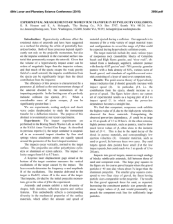
46th Lunar and Planetary Science Conference (2015)
2324.pdf
ROCK ABRASION AND LANDSCAPE MODIFICATION BY WINDBLOWN SAND AS
DOCUMENTED BY THE MSL CURIOSITY ROVER
N.T. Bridges1, D.L. Blaney2, M.D. Day3, K.E. Herkenhoff4, N.L. Lanza5, S. Le Mouélic6, F.J. Martin-Torres7, S. Maurice8, C.E.
Newman9, H.E. Newsom10, R.C. Wiens5, M-P. Zorzano11, and the MSL Science Team ; 1Applied Physics Laboratory, 11100
Johns Hopkins Road, Laurel, MD 20723 ([email protected]); 2Jet Propulsion Laboratory, California Institute of
Technology, Pasadena, CA 91109; 3Department of Geological Sciences, Jackson School of Geosciences, University of Texas at
Austin, Austin, Texas 78705; 4U.S. Geological Survey, Flagstaff, AZ 86001; 5Los Alamos National Laboratory, Los Alamos,
NM 87545; 6CNRS/Université de Nantes, 44322 Nantes cedex 3, France; 7Instituto Andaluz de Ciencias de la Tierra (CSICUGR), Granada, Spain; ; 8IRAP, CNRS-Université Toulouse, 14 av. E. Belin, 31400 Toulouse, France; 9Ashima Research,
Pasadena, CA 91106; 10Department of Earth and Planetary Sciences, University of New Mexico, Albuquerque, NM 87131-0001;
11
Centro de Astrobiología (INTA-CSIC), Madrid, Spain
Introduction
Mars is a dry planet, with actively blowing sand in
many regions [1-5]. In the absence of stable liquid water
and an active hydrosphere, rates of chemical weathering
are slow, such that aeolian abrasion is a dominant agent
of landscape modification where sand is present and
winds above threshold occur at sufficient frequency.
Reflecting this activity, ventifacts, rocks that have been
abraded by windborne particles, are common on the
Martian surface. They provide invaluable markers of the
Martian wind record and insight into climate and
landscape modification. Yardangs are also indicative of
sand abrasion, but, given their size of several meters to
kilometers, reflect larger scale wind patterns.
The Mars Science Laboratory (MSL) Curiosity
payload is well suited for studying ventifacts and modern
wind patterns which are relevant for understanding
current and past abrasion/wind conditions [6]. The rover
mast cameras, Navcam, Mastcam, and the ChemCam
Remote Micro Imager (RMI) provide images of varying
coverage and spatial scale. In particular, the Mastcam
M100 (right eye) and ChemCam Remote Micro Imager
(RMI), with pixel scales 74 [7] and 19.6 µrad [8-9],
provide fine details of rock textures. The ChemCam Laser
Induced Breakdown Spectrometer (LIBS) gives elemental
composition as a function of depth down to ~10s of µm
beneath rock surfaces, penetrating the outer dust layer and
providing clues to the presence of any rock coating or rind
[11,12]. The Rover Environmental Monitoring Station
measures wind speed and direction, pressure, relative
humidity, air temperature, ground temperature, and
ultraviolet radiation, with 1 Hz sampling for over 5 min
every hour and periodic (generally daily) observations for
durations of an hour or more [13]. Finally, the HiRISE
camera on the Mars Reconnaissance Orbiter provides 25
cm pixel-scale images which are used to compare MSL
results to regional scale geology and topography,
including the presence and inferred formative wind
directions of dunes and yardangs. Here we provide the
latest measurements and interpretations of the rock
abrasion record in Gale Crater, adding to the data that was
previously analyzed through Sol 100 [6].
Methods
Ventifacts through Sol 438 were identified in systematic
searches through all M100 mosaics and associated RMI
and MAHLI images, the three datasets with the
highest spatial resolution (similar methods to [6]).
Diagnostic characteristics were tabulated for each
ventifact, including 1) overall shape (facet, keel, basal
sill), 2) macro-texture (elongated pits, scallops, flutes,
grooves, and rock tails) and 3) micro-texture
(lineations). Once found, rocks were located in the
lower resolution Navcam data, such that the location,
size (height and width), and orientation of most
ventifacts could be computed using Navcam stereo
mosaics in the Mars Science Laboratory InterfaCE
(MSLICE) software package available to the MSL
Team. Several Mastcam orthoproducts were also made
to more accurately map ventifact features. The
presence of rock coatings/rinds was assessed by
looking at the vertical distribution of mobile elements
such as lithium in LIBS data [12] and then comparing
to the rock texture (e.g., abraded vs. unabraded). The
ventifact locations were projected onto the color
portion of an orthorectified High Resolution Imaging
Science Experiment (HiRISE) image with and overlain
rover traverse path and sol location markers. The
orientations were also compiled into rose diagrams
and, following past convention, shown as a function of
upwind direction. These were compared to directions
of local yardangs [14], migration direction and
orientations of dunes in the Bagnold dunefield to the
southwest [15], and winds predicted by the MarsWRF
atmospheric model [6]. Finally, general geomorphic
observations, such as valley widening and distribution
of boulders, was noted qualitatively using Mastcam
mosaics.
Results
Ventifacts are found throughout the traverse and
contain one or more diagnostic features and textures:
Facets,
keels,
basal
sills,
elongated
pits,
scallops/flutes, grooves, rock tails, and lineations (Fig.
1). Keels at the junction of facets are sharp enough to
pose a hazard MSL’s wheels in some areas. Other
rocks show basal undercuts indicative of enhanced
scour in the zone of highest abrasion.
Geomorphic and textural patterns on outcrops
indicate retreat of windward faces. For example,
Moonlight Valley and other depressions are
demarcated by undercut walls and scree boulders, with
46th Lunar and Planetary Science Conference (2015)
the valley interiors containing fewer rocks, most of which
show evidence for significant abrasion. Together, this
suggests widening and undercutting of the valley walls,
and erosion of interior rocks, by windblown sand.
The rose diagram of ventifact-derived wind azimuths
shows inferred winds shows a strong bias to westerly flow
(38 measurements, or 79% percent of sample), with the
strongest trend in the 210-240° bin (Fig. 2) [6]. In
contrast, the direction of scarp retreat and rock tails in the
Sheepbed mudstone to the northeast of Rocknest indicates
northeasterly winds that, based on cosmic ray exposure
ages, occurred 78±30 Ma [15]. Both datasets disagree
with the direction of strongest winds from MarsWRF
predictions of the strongest winds coming from the SSE
and the NNW-SSE orientation of Gale Crater yardangs.
Finally, dune and ripple orientations and displacement in
the Bagnold dunefield to the southwest indicate strong
bidirectional winds from the NW and ENE [16]. The
disparity in these datasets may reflect the effects of local
topography and a preserved record of rare sand
mobilizing events that are best seen at the field (ventifact
scale), whereas yardangs and bulk dune motion are more
reflective of longer term mesoscale winds.
As a preliminary investigation of the potential for using
LIBS to assess abrasion of any rock coatings/rinds, the
670.9 nm lithium line (corresponding to an unresolved
doublet at 670.96/670.98 nm [12]) for 5 LIBS observation
points each on Bathurst Inlet and Jake M. rocks were
compared [6]. They show clear differences as a function
of depth for shots 4–30, beneath the dust cover. Whereas
line intensity in Bathurst, particularly raster points 3–5,
decreases with depth, all five of the Jake points remain
more or less constant, even point 1 that exhibits higher
overall Li. The LIBS points on Jake are located on a
rough surface with elongated pits that are characterized by
abrasion subparallel to the surface. The LIBS points on
Bathurst Inlet are on a smooth surface that qualitatively
appears less abraded.
Discussion
Ventifacts and other evidence for rock abrasion
are found throughout the rover drive, yet HiRISE images
do not show any dark sand dunes in the traverse so far, in
contrast to the large dune field to the south that is
migrating up to 2 m per year. This indicates that rock
abrasion was likely more dominant in the past, a
hypothesis consistent with rapid scarp retreat in
Yellowknife Bay [16]. Ventifacts and evidence for
bedrock abrasion have also been found at the Pathfinder,
Spirit, and Opportunity sites, areas, like the Curiosity
traverse so far, that lack evidence for current high sand
fluxes. Yardangs are also common on the planet,
regardless of whether local sand is mobile. This suggest
that abrasion on Mars is an episodic process driven by the
passage of sand in which rock retreat rates, based on
fluxes of current active dunes, may reach 10s of microns
per year [5]. Such a process has acted, over long time
2324.pdf
scales, to imprint upon the surface a record of sand
activity.
Fig. 1: a): Jake rock. At left is a color Mastcam 34 image
(ML_401573007EDR_S0042100AUT_04096M)
with
superposed RMI mosaics shown in grayscale and the
location of LIBS spots as red dots (lithium peaks at 670.9
nm from the right- most raster described in text); b) Slide
Mountain rock (mcam01715, Sol 417) showing prominent
undercutting, presumably from southwesterly winds, c)
Classic faceted ventifact (mcam01675, Sol 404).
Fig. 2: Upwind directions based on several datasets and
models.
References [1] Silvestro, S. et al. (2010), GRL, 37,
doi:10.1029/2010GL044743. [2] Chojnacki et al. (2011),
JGR, 116, doi:10.1029/2010JE003675. [3] Hansen, C.J. et
al. (2012), Science, 331, 575-578. [4] Bridges et al. (2012a),
Geology, 40, 31-34. [5] Bridges et al. (2012b), Nature, 485,
339-342. [6] Bridges et al. (2014), JGR-Planets, 119, 13741389. [7] Malin, M.C. et al. (2010), Lun. Planet. Sci. XLI,
1123. [8] Maurice, S. et al. (2012), Space Sci. Rev., doi:
10.1007/s11214-012-9912-2. [9] Le Mouélic, S. et al.
(2014), Icarus, doi10.1016/j.icarus.2014.05.030 [10] Wiens,
R.C. et al. (2012), Space Sci. Rev., doi: 10.1007/s11214-0129902-4. [11] Lanza, N.L. et al. (2014), GRL, 41, 5755-5763,
doi:10.1002/2014GL060329. [12] Ollila, A.M. et al. (2014),
JGR -Planets, 119, 255-282, doi:10.1002/2013JE004517.
[13] Gomez-Elvira, J., et al. (2011), 4th International
Workshop on the Mars atmosphere. [14] Day, M.D. et al.
(2014), GSA Annual Meeting, 202-13. [15] Silvestro, S. et al.
(2012), Geology, 41, 483-486. [16] Farley, K.A. et al.
(2014), Science, 343,1247166.


© Copyright 2026