
ARAM DORSUM: A NOACHIAN INVERTED FLUVIAL CHANNEL
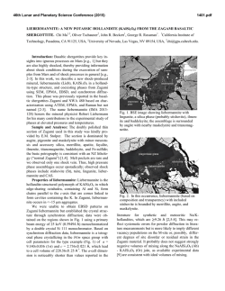
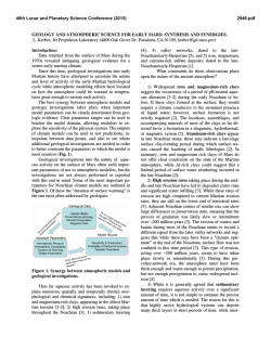
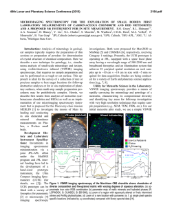
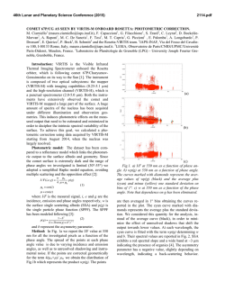
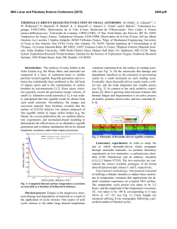
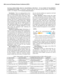
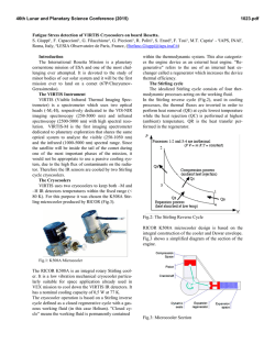
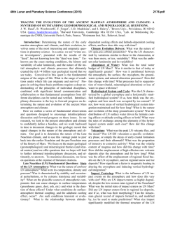
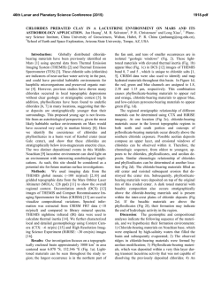
46th Lunar and Planetary Science Conference (2015)
1321.pdf
ARAM DORSUM: A NOACHIAN INVERTED FLUVIAL CHANNEL SYSTEM AND CANDIDATE
EXOMARS 2018 ROVER LANDING SITE. M. Balme1, P. Grindrod2, E. Sefton-Nash2, J. Davis3, S. Gupta4, P.
Fawdon1, P. Sidiropoulos5, V. Yershov5, & J-P. Muller5. 1Dept. of Physical Sciences, The Open University, Milton
Keynes, UK, 2Dept. of Earth and Planetary Sciences, Birkbeck, University of London, UK. 3Dept. of Earth Sciences,
University College London, UK. 4Dept. of Earth Science & Engineering, Imperial College, London, UK, 5Mullard
Space Science Laboratory, University College London, UK.
Introduction: The search for life on Mars is a cornerstone of international solar system exploration. In
2018, the European Space agency will launch the ExoMars Rover to further this goal. The Rover’s key science objectives [1] are to: 1) search for signs of past and
present life on Mars; 2) investigate the water/geochemical environment as a function of depth in the shallow
subsurface; and 3) to characterise the surface environment. ExoMars will drill into the sub-surface to look for
indicators of past life using a variety of complementary
techniques, including assessment of morphology (potential fossil organisms), mineralogy (past environments) and a search for organic molecules and their chirality (biomarkers).
The choice of landing site is vital if the objectives
are to be met [1]. It must: (i) be ancient (≥3.6 Ga); (ii)
show abundant morphological and mineral evidence for
long-term, or frequently reoccurring, aqueous activity;
(iii) include numerous sedimentary outcrops that (iv) are
distributed over the landing region (the typical Rover
traverse range is a few km, but ellipse size is ~ 100 by
15 km). ‘Engineering constraints’ also apply, including:
(i) latitude limited to 5º S to 25º N; (ii) maximum altitude of the landing site 2 km below Mars’s datum; and
(iii) few steep slopes within the ellipse.
In 2014, two international workshop were held to
discuss potential landing sites. The outcome of these
workshops was a shortlist of four possible sites: Aram
Dorsum, Hypanis Delta, Mawrth Vallis, and Oxia
Planum. We proposed the Hypanis and Aram Dorsum
sites and led the scientific presentations for these sites
at the Workshops. Here, we present the science case for
Aram Dorsum – the case for Hypanis is made in [2]
Overview: The Aram Dorsum site in western Arabia Terra (Fig. 1) is situated about half way between
Meridiani Planum and the dichotomy boundary, where
Arabia Terra meets the northern lowlands. Aram Dorsum itself is a flat-topped, branching, sinuous ridge-like
feature that is surrounded by smoother marginal materials (Figs. 2, 3). We interpret Aram Dorsum to be a former fluvial channel system that has been preserved in
positive relief by differential erosion (Fig 3). Such features are fairly common on Mars [3], and are also wellstudied on Earth (e.g., Fig. 4 and [4]). Aram Dorsum is
interesting in that it is overlain by overburden materials
including both ejecta from nearby 10-50km diameter
craters, and regionally-extensive, sedimentary layers [5]
(Fig. 2). These materials are Noachian, so Aram Dorsum itself must be at least this old.
Fig 1. Context MOLA map showing regional setting for
the Aram Dorsum site (white box). Blue and purple
mark the lowest regions, yellow and brown the highest.
Fig 2. Aram Dorsum site and 2018 landing ellipse.
Blue/green areas are Aram Dorsum or its marginal
units. Flow is inferred to be East-to-West. Purple areas
are regionally extensive, Noachian-aged sedimentary
units that superpose all other units within the study
area. Outliers of these units occur across the study areas and in the ellipse. Non-coloured areas are mainly
local overburden material.
Observations: The Aram Dorsum main channel
system is sinuous to meandering and contains multiple
channels. These are both laterally and also vertically
46th Lunar and Planetary Science Conference (2015)
separated from one another (cf. Fig. 4), as shown by
cross-cutting relationships and traces of older, now buried, channels alongside and underneath the main channel system. In the west of the study area, the channel
system is a well-defined, single thread channel. In the
east the plan-view pattern is more consistent with an
anastomosing, or multi thread channel, sometimes separated by lozenge-shaped ‘islands’. The main channel
system is superposed upon a smooth, low relief channelmarginal unit that is also overlain by local and regional
overburden materials. Inliers of this unit are seen in erosional windows within the overburden materials. At
HiRISE scale, the channel marginal unit contains smallscale (10-20m) polygonal fracture patterns. The channel
marginal unit is also present around the four (or more)
smaller, tributary inverted channel systems that are seen
across the study area and feed into the main trunk. All
of these smaller systems appear to be forming in or beneath the channel marginal unit.
Fig 3. CTX mosaic showing the Aram Dorsum ridge system (black arrows). Smaller, tributary ridges (e.g., at
white arrow) connect to the main trunk system.
Interpretation: The presence of channels at different stratigraphic positions demonstrate that there was
long-lived fluvial activity, not catastrophic flow. This is
reinforced by the overall morphology of the channel,
which is consistent with a river-like fluvial system, not
a catastrophic flow. That channels are set within the
channel marginal unit, as well as on top of it, suggests
that the channel marginal unit is a sedimentary deposit.
The main channel system is not braided, and there is little evidence of unconfined channel migration. Instead,
there are several stable sinuous paths, with multiple lateral branches. This implies that, when the main trunk
formed, the channel has competent banks and that chan-
1321.pdf
nel migrated laterally by avulsions, or was anastomosing, rather than by unconstrained lateral ‘sweeping’. In
the absence of land plants [e.g., 6], other mechanisms
that could stabilise the banks include ice-cementation or
a high clay content.
Aram Dorsum is a Noachian-era, aggradational,
multithread/sinuous river-system, including small tributaries and extensive flood plain-like marginal deposits.
Fig. 4. Inverted channels in Utah, USA. Arrows show a
stratigraphically distinct channel segment overlain by a
younger channel, rather than a junction in the channel.
After Williams et al., 2009 [4]
Relevance to ExoMars Science Goals: Aram Dorsum displays clear evidence for the long-lived action of
water in the Noachian (possibly even early/mid Noachian). Although the inverted channel likely contains
mainly coarse-grained sedimentary outcrops, the channel marginal unit is probably fined-grained sediments,
or could contain lenses and/or ‘islands’ of fine grained
material suitable for preserving biosignatures. Importantly, the system has been exposed from beneath
>100s of metres of overburden materials; outliers of
such overburden are still present. Such burial/exhumation greatly benefits preservation of biosignatures. The
areas of interest defined by the channel marginal units
and inliers within the overburden cover a significant
proportion of study area, so potential targets are distributed throughout the ellipse.
References: [1] ESA ExoMars LSSWG (2013),
http://exploration.esa.int/mars/53455-call-for-exomars2018-landing-site-proposals/ Ref: EXM-SCI-LSSESA/IKI-001 [2] Sefton-Nash, E. et al., (2015, this volume), LPS XLVI, Abstract #1414 [3] Pain et al. (2007)
Icarus 190, 478-491 [4] Williams, R.M.E., et al. (2009)
Geomorphology, 107, 300-315 [5] Hynek, B.M., et al.
(2002), JGR 107, DOI: 10.1029/2002JE001891 [6] Cotter, E. (1978), in: Miall, A.D. (Ed.), Fluvial Sedimentology, Can. Soc. Pet. Geol. Mem. 5, 361–383.
© Copyright 2026