Testing for the Influence of Insolation on Formation and Growth of
46th Lunar and Planetary Science Conference (2015)
1489.pdf
TESTING FOR THE INFLUENCE OF INSOLATION ON FORMATION AND GROWTH OF HOLLOWS ON MERCURY.
E. M. Molter1 and C. M. Dundas2, 1Macalester College, 1600 Grand Ave., Saint Paul, MN 55105
([email protected]), 2U. S. Geological Survey, 2255 N. Gemini Dr., Flagstaff, AZ 86001 ([email protected]).
!!
!
Introduction: Hollows are fresh-appearing, irregular, shallow (mean depth ∼47m [1]), flat-bottomed,
rimless depressions with diameters ranging from tens
of meters to a few kilometers [2]. Rocks hosting hollows are usually found on the floors, walls, or central
peaks of impact craters of all sizes and ages [1,3]; however, some hollows are found far from craters. Hollows are widespread across the surface in low-albedo
materials [3,4]. The steep sides, sharp angles, and lack
of superimposed impact craters imply that hollows are
relatively young, and may still be forming or growing
[2]. The mechanism governing their formation, however, remains unknown. Volcanism, once a widespread
process on Mercury [5], created irregular depressions
such as pit craters, calderas, and pyroclastic vents on
the planet's surface. However, these features are generally larger than hollows, with sloping floors and a
much redder color [6,7]. Hollows are more likely to
form from volatile deposits similar to those that form
the Martian "Swiss cheese" terrain [e.g., 8].
The link between hollows and impact craters suggests that hollow-forming material may be exhumed
from depth and exposed to an extremely low-pressure,
high-temperature environment. Such a drastic environmental change could cause volatiles sequestered in
the material to become unstable, sublime, and escape
to space, leaving behind a collapse pit [2]. Alternatively, a substance present in the exhumed material may be
susceptible to space weathering [2]. If the release of
volatiles is temperature-dependent, a link between insolation intensity and occurrence of hollows is expected. Previous studies have found a weak correlation
between solar exposure and hollow formation [1,3].
They observe that the total area covered in hollow material, if binned by longitude, peaks around 0o and
180o, the longitudes of Mercury's "hot poles”; however, a large unexplained anomaly exists at -50o E [1].
Binned by latitude, a strong peak is found between 0o
and 30o, but this may be attributable to observational
bias. Some evidence has also been found that hollows
form preferentially on sun-facing slopes. In many locations hollows appear on slopes that experience
maximal solar heating [3]. In fact, where hollow sites
display a preferred slope aspect, the correlation between hollow formation and insolation is fairly strong
[1]. However, only 8% of sites in that study were
found to have a clear preferred aspect, and since many
hollows are found on flat surfaces or in groups containing individuals on slopes with opposing aspects, [1]
concluded that preferential formation on sun-facing
slopes is not common to all hollows. In this abstract
we carry out a quantitative, global investigation of
whether hollow formation is primarily driven by insolation-induced processes.
Methods: We analyzed all PDS-released (as of
June 2014) MESSENGER Mercury Dual Imaging System Narrow Angle Camera (MDIS-NAC) images with
a resolution better than 40 m/px and within ±1 degree
latitude and longitude of the hollow sites identified by
Blewett et al. [3]. The selected images were projected
using the USGS's Map Projection On the Web (POW;
astrocloud.wr.usgs.gov) tool, which performs standard
image reduction and projection algorithms derived
from the USGS's ISIS (Integrated Software for Imagers and Spectrometers; isis.astrogeology.usgs.gov)
software. The projected images were loaded into
ArcMap GIS software for analysis. We searched every
image in the dataset for hollows and categorized them
by morphology. The first category, ellipses, includes
morphologically simple, roughly elliptical hollows
occurring on flat-appearing surfaces. The second category, chains, includes groups of two to four linked
elliptical hollows on flat ground for which a single
linking direction can be determined. The third category, rim hollows, includes hollows occurring along the
walls and rims of impact craters. Craters partially covered by shadows were excluded, since it was impossible to determine whether hollows were present on the
shaded side. Morphologically complex hollows, hollows occurring on slopes not associated with crater
rims, hollows too small or unclear to allow an accurate
categorization, and hollows that could not be distinguished from craters or volcanic features were not marked. We used ArcMap to extract the azimuth angle of
the lines and ellipse major axes, as well as the range of
angles along crater rims subtended by hollows.
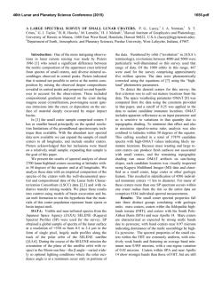
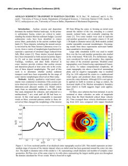
Results: Our dataset consisted of 316 roughly elliptical hollows, 626 chains of hollows, and 160 craters
with rim hollows. Rose diagrams displaying azimuth
information for the ellipses and crater rims are shown
in Figures 1 and 2 respectively. All three categories
display a mean orientation along the northwest-southeast axis, with values of 174o for the ellipses, 149o
for the chains, and 306o for the crater hollows, where
46th Lunar and Planetary Science Conference (2015)
0o is north. Although we attempted to create a dataset
covering the entire northern hemisphere, the images
that fit our selection criteria were grouped strongly by
longitude. For example, more than half of the chains
(330/626) fell between -90o and -45o longitude, a
strong anomaly that matches the one found by Thomas
et al. [1] near -50o longitude. Almost no data were
collected between -180o and -90o or between -45o and
90o. These large inhomogeneities mean that the data
do not necessarily represent global trends and that regional conditions may have an important effect.
Figure 1. Major axis orientation angles of elliptical hollows. Original data ranged from 0o to 180o but
was mirrored for better visual representation.
1489.pdf
ny crater walls and, when forming on flat ground, growing preferentially on their sunny sides. Since Mercury's axial tilt is almost zero, south-facing slopes in the
entire northern hemisphere receive more sun than
north-facing slopes, leading to the prediction that hollows will orient themselves along the north-south axis.
Our data show evidence of this; however, the orientation direction is skewed westward from north, especially for the crater rim hollows. Much of our data
come from the longitude range -90o to -45o, so regional
conditions may affect our data. These longitudes are to
the west of Mercury's "hot pole" at 0o, which means
that east-facing crater or hollow walls experience a
higher maximum temperature and more intense solar
heating and weathering than west-facing walls. The
westward skew in the data is therefore consistent with
a dependence of hollow growth on insolation intensity;
however, without more extensive data from other longitudes this cannot be confirmed.
Combined with evidence from previous studies
[1,3] that hollows weakly prefer sun-facing slopes, our
results are overall consistent with the hypothesis that
hollows form and grow from insolation-driven escape
of volatile materials from Mercury's subsurface in a
process reminiscent of the 'Swiss cheese' terrain in the
Martian south polar region [8]. As in the case of
'Swiss cheese,' the complex structures of many hollows
may arise from the mergers of simple landforms. This
finding adds to a growing body of evidence [6,10,11]
that Mercury houses more volatiles than predicted by
some models for the planet's formation [12,13,14].
!
Figure 2. Angles along impact craters subtended
by hollow material.
!
Discussion: Our results show a clear preferred
orientation for hollows in all three categories: on the
northwest side of craters and along a northwest-southeast axis for chains and ellipses. This direction is
consistent with hollows forming preferentially on sun-
Acknowledgements: EMM was funded by the
2014 Research Experience for Undergraduates program at Northern Arizona University. CMD was funded by Planetary Geology and Geophysics grant
NNH14AX97I. We thank Trent Hare for assistance
with ArcMap.
References: [1] Thomas R. J. et al. (2014) Icarus,
229, 221. [2] Blewett D. T. et al. (2011) Science, 333,
1856. [3] Blewett D. T. et al. (2013) JGR, 118, 1013.
[4] Xiao Z. et al. (2013) JGR, 118, 1752. [5] Head J.
W. et al. (2007) Space Sci. Rev., 131, 41. [6] Kerber L.
et al. (2011) Planet. Space Sci., 59, 1895. [7] Goudge
T. A. et al. (2014) JGR, 119, 635. [8] Byrne S. & Ingersoll A. P. (2003) Geophys. Res. Lett., 30, 1696. [9]
Head J. W. et al. (2011) Science, 333, 1853. [10] Peplowski P. N. et al. (2011) Science, 333, 1850. [11]
Nittler L. R. et al. (2011) Science, 333, 1874. [12] Lewis, J. S. (1973) Ann. Rev. of Phys. Chem., 24, 339.
[13] Fegley B. & Cameron A. G. W. (1987) Earth &
Planetary Sci. Lett., 82, 207. [14] Benz W. et al. (1988)
Icarus, 74, 516.
© Copyright 2026
