
automated detection of impact craters and volcanic rootless cones in
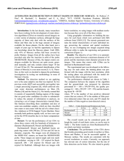
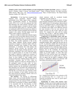
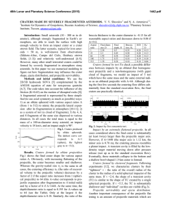
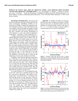
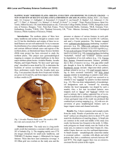
46th Lunar and Planetary Science Conference (2015)
2316.pdf
AUTOMATED DETECTION OF IMPACT CRATERS AND VOLCANIC ROOTLESS CONES IN MARS
SATELLITE IMAGERY USING CONVOLUTIONAL NEURAL NETWORKS AND SUPPORT VECTOR
MACHINES. L. F. Palafox1, A. M. Alvarez2, C.W. Hamilton1, Lunar and Planetary Laboratory, University of Arizona, 1629 E University Blvd, Tucson, AZ 85721, USA, 2Department of Biomedical Engineering, University of Arizona, 1127 E James E Rogers Way, Tucson, AZ 85721, USA ([email protected]).
Introduction: Recent advances in scene recognition techniques, like the use of Convolutional Neural
Networks (CNNs), are supplanting more traditional
classification techniques like Support Vector Machines
(SVMs) [1]. CNNs are designed to process images that
have many elements in them (e.g., natural scenes) using
local features (i.e., independent measurable properties
or informative derived values, which facilitate subsequent learning and generalization steps). Furthermore,
using local features to perform the classification, instead of processing the image as a whole, makes CNNs
more efficient for examining large images.
Martian image databases, like those for the Mars
Reconnaissance Orbiter (MRO) High Resolution Imaging Science Experiment (HiRISE) [2], consist of large
(up to 3.4 GB) images—each of which may resolve a
diverse range of geological units formed by multiple
processes. For instance, it is possible to have impact
craters and volcanic craters occurring in close proximity to one another within the same scene. These landforms are associated with different formation mechanisms, yet may exhibit geomorphological similarities
though the process of equifinality [3]. Therefore, it can
be challenging to distinguish between these landforms
and their origins. This task is generally accomplished
through application of expert knowledge and heuristic
reasoning, but a range of automated approaches may
also be applied for landform recognition.
Some automated computer vision techniques rely
heavily upon handcrafted transformations, such as
Hough transforms, to accentuate features during a preprocessing step and make them easier to classify [4].
The problem with this approach is that it is tailored to a
particular problem and does not extrapolate well to the
detection of other landforms or processes. Furthermore, these ad hoc solutions depend on the dataset
itself in terms of the image resolution and feature size.
CNNs, along with Deep Networks, are showing great
advances and establishing new benchmarks in image
recognition, without the requirement for any preprocessing to facilitate the classification.
To test the applicability of CNNs and SVMs to the
analysis of planetary remote sensing data we have used
these systems to the classification of impact craters and
Volcanic Rootless Cones (VRCs) within HiRISE images. VRCs are small (generally sub-kilometer in diameter) cratered cones formed through processes of explosive lava–water interaction [5]. These landforms are
common in terrestrial environments were lava has
flowed over water-bearing sediments and permafrost
[6], and are inferred to have formed analogous groups
of cratered cones in volcanic regions of Mars, such as
Elysium Planitia [7]. However, these landforms are of
a similar scale to some impact craters, and especially
secondary craters, which can make it difficult to for the
non-expert to discern between these landform types.
In this study, we present quantitative results
demonstrating the advantages of using CNNs for automated landform classification over traditional SVMs.
Methods: Classification Techniques. In Machine
Learning, classification generally involves a family of
supervised learning methods in which both data and
data labels are required. A label represents a true or
false state of the feature to classify, these features are
commonly known as classes. For example, an image
containing a VRC would be labeled as one, while an
image not containing a VRC would be labeled as zero.
Classification can be extended to multiple classes (e.g.,
impact craters, recurring slope lineae, dust devils,
clouds, etc.), thus enabling the construction of powerful classifiers that are able to automatically identify and
annotate multiple constituents within an image.
Neural Networks and Convolutional Neural Networks (CNNs). Neural networks can be thought of as a
connected set of classifiers, each of which is tuned to
generate a specific decision boundary and classify simple spaces. By connecting them, the complexity of the
classes they can identify increases. Traditionally neural
nets have an input layer, which receives the input; a set
of hidden layers, which serves as the classifier; and an
output layer, which gives the result of the classification
[8]. CNNs are a variation of the architecture of traditional neural networks, in which different inputs share
weights, rather than each input having a single weight
[9]. The purpose of sharing weights is to take advantage of the locality consistency in the data, which is
a prominent characteristic in images, where nearby
Digital Numbers (DNs) in patches of an image are
strongly correlated. Moreover, CNNs use patches and
impose convolutions within the architecture, which
makes them robust against some image transformations, such as translations, rotations, and scaling.
In remote sensing images, different landforms like
VRCs and impact craters, can exhibit considerable
variation in terms of their morphological expression
and scaling, as well as variations in appearance due to
lighting conditions. In classifying planetary imagery,
CNNs can overcome some of these obstacles to auto-
46th Lunar and Planetary Science Conference (2015)
mated landform classification by being more robust to
image transformation than traditional neural networks
and doing away with image pre-processing.
Support Vector Machines (SVMs). In SVMs a decision boundary between two classes (i.e., the line that
separates one class from the other) is set in such a way
that maximizes the distance between this decision
boundary and the closest points in each class. Each of
these distances is known as a support vector and each
distance is dependent on a specific kernel. For the purpose of most flexibly defining the decision boundary
based on the given training data set, we used a Radial
Basis Function (RBF) kernel. SVMs have precedent in
both volcanic and planetary sciences as individuals
have used SVMs to both identify volcanic features on
earth and craters on the moon [10].
Experiments: We chose a set of images from the
HiRISE dataset and selected patches that contain the
features that we are interested in, namely impact craters
and VRCs in northeastern Elysium Planitia [7]. We
manually labeled the patches to create a dataset that we
can use to train the classification algorithms.
The CNN, as well as the SVM, were implemented
in MATLAB, with the CNN using a custom library,
while the SVM approach used existing MATLAB libraries. The CNN architecture was pre-trained using an
autoencoder to find descriptive features of the martian
surface. The autoencoder has one hidden layer with 50
units. Then we used CNN that had the results of the
autoencoder as pre-training data, along with two convolutional layers. The dataset we used to train had 50
manually labeled examples of rootless cones and 100
negative examples, which are parts of the image that do
not contain a significant feature. The SVM was trained
2316.pdf
using an RBF as a kernel, and we used 10-Fold Cross
Validation to find the parameters of the kernel.
Results: We show the results of training the SVM
in our dataset, and classifying 50,000 points at random
in the original image in Figure 1 (Center), while we
present the results of using the CNN under the same
conditions in Figure 1 (Right). For comparison, we
show the original image as well in Figure 1 (Left) to
see the original positions and locations of the VRCs.
Discussion and Conclusions: Applied to the training dataset, both approaches reach similar results.
However, with unseen data, the CNN exhibits fewer
false positives than the SVM (Figure 1). This is because the CNN architecture builds interdependencies
between pixels that allow the network to generalize,
while the SVM treats each training sample as independent points. This generalization in the CNN results
in better performance in unseen examples.
Acknowledgement: This research is supported by
NASA Mars Data Analysis Program (MDAP) Grant #
NNX14AN77G.
References: [1] Huang, F.J. and LeCun, Y. (2006)
CVPR, 284–291. [2] McEwen A.S. et al. (2007) J. Geophys. Res., 112, 2156–2202. [3] Baker V (2011)
Planetary Geo. Field. Symp., 95, 5–10. [4] Michael
G.G. (2003) Planetary and Space Sci, 563–568.
[5] Thorarinsson, S (1953), Bull. Volcanol., 14, 1, 3–
44. [6] Hamilton et al. (2010) Bull. Volcanol., 72(4),
499–467. [7] Hamilton et al. (2011) J. Geophys. Res.,
116, E03004. [8] Hornik, K. et al. (1989) Neural Networks, 2, 359–366. [9] LeCun, Y. et al. (1990) ICPR,
35–40. [10] Decoste, D. and Scholkopf, B. (2002) Machine Learning, 46, 161–190.
Figure 1. A: Original image containing VRCs (i.e., cratered cones) constructed above a lava flow surface (HiRISE
ESP_018747_2065; Central Latitude and Longitude: 26.26°N, 173.55°E; Sub-Solar Azimuth: 9.7°). B: Results of
classifying 50,000 randomly selected patches using a CNN. C: Result of classifying the same patches using an SVM.
In B and C red boxes represent positive VRC detections and blue boxes represent null detections.

© Copyright 2026