
2386
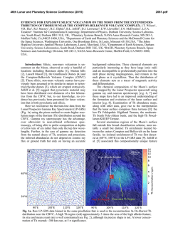
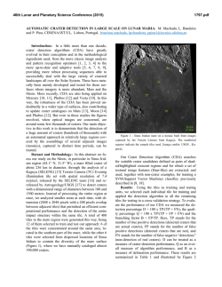
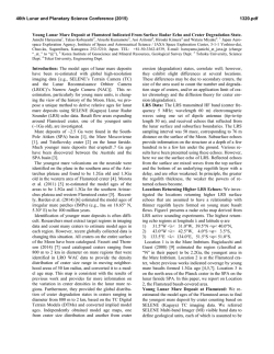
46th Lunar and Planetary Science Conference (2015)
2386.pdf
EXCAVATION DEPTHS OF SMALL DIAMETER CRATERS ON A PYROCLASTIC DEPOSIT NEAR
NORTHERN RIMAE BODE, THE MOON. A. E. Huff1, J. J. Hagerty2, J. A. Skinner Jr.2, C. M. Fortezzo2, T. A.
Gaither2, and L. R. Gaddis2. 1Northern Arizona University, School of Earth Sciences and Environmental
Sustainability, Flagstaff, AZ 86001 ([email protected]); 2USGS, Astrogeology Science Center, Flagstaff, AZ 86001.
Introduction: Geologic mapping and analysis of
planetary surfaces is constantly evolving and researchers are generating new ways of interpreting and mapping the extensive influx of recently available lunar
data. The Copernicus quadrangle has been an area
of interest on the Moon because the region contains examples of major surface processes (e.g., volcanism, impact cratering, tectonic modification), as well
as materials representative of all lunar epochs[1].
To extract as much scientific information as possible
from the Copernicus regions, we are combining traditional geomorphological mapping techniques with
compositional data derived from remote sensing
observations of the lunar surface. To support this
approach, this study mapped the distribution of lunar
pyroclastic deposits, possible source vents, and craters
within the quad to determine the areal extent, foci,
and volume of pyroclastic materials as a precursor for
future compositional investigations.
Data Sets: We used data from the Lunar Reconnaissance Orbiter Camera Wide Angle Camera (LROC
WAC), the Kaguya Terrain Camera (TC), Visible
Camera and TiO2 global map, the Clementine
Ultraviolet Vis-ible Spectrometer (UVVIS), and the
Clementine Global Iron, Titanium, and Optical
Maturity maps to map features in ArcGIS.
Background: Contrary to terrestrial pyroclastic deposits, lunar pyroclastic deposits (LPDs) are typically
dark basaltic glass deposits that mantle the underlying
substrate [2]. LPDs can overlie craters, mare, highlands, and mare/highland boundaries [2]. Similar, low
albedos often obscure the boundary between LPDs and
mare deposits, therefore identification depends on
textural differences between the flatter, smoother mare
and rougher, irregular LPDs.
The surface texture of LPDs is accredited to the
Strombolian eruptive process producing pyroclastic
glass beads [2]. Driven by volatile exsolution, magma
ascended rapidly through dunite-lined conduits and
was erupted onto the lunar surface thus allowing the
magma to essentially remain unaltered during its ascent
and as such the glasses represent windows into the lunar
mantle [3 - 5]. The magmas that produced the LPDs
are the result of partially melting source regions within the lunar mantle. Once it is known how much
partial melting the magma underwent, the composition of the source region can be mathematically derived, thus providing critical information about the
composition of the lunar mantle [3 - 5].
Source Vents: Identifying source vents was a
primary objective for this project, and their locations
were applied to understanding pyroclastic deposit distibutions within the region. If the thickness of LPDs
can be correlated with source vent locations, then the
eruption dynamics can be derived, which in turn has
implications for understanding characteristics of the
source region that produced the pyroclastic magmas
[3 – 5].
Previously identified LPDs in the Copernicus
quadrangle (i.e., Rimae Bode and West Sulpicius Gallus) were used to compare newly mapped deposits
within the quad (via textural and spectral characteristics). To locate potential pyroclastic deposits, 534
possible source vents throughout the quad were identified at 1:250,000 scale using the LROC WAC mosaic. Possible vent sources were identified by their
linear to curvilinear nature and locations correlative
to rough and irregular low albedo deposits.
LPD Mapping: Morphologic variations within
the boundaries of the LPDs were mapped in an effort
to determine the cause of the morphologic differences. Three different units were mapped based on
albedo and texture: very low albedo materials as dark
mantle (dm), relatively low albedo materials as intermediate mantle (im), and plains domes (pd) where
there were occurrences of annular positive relief.
Mapping began within Rimae Bode and West
Sulpicius Gallus with additional mapping northeast of
Montes Carpatus and within the Hortensius region
west of Copernicus crater. The Hortensius region
contains volcanic domes which were also mapped as
part of this project, due to the abundance of volcanic
features in that region.
These postulated LPDs were mapped at an
average scale of 1:250,000 based on data from the
Kaguya TC, Visible Camera, and TiO2 global map.
Cross referencing with Clementine UVVIS and the
global iron, titanium, and optical maturity data sets
allowed for consistency with observed patterns from
known LPDs in Rimae Bode and West Sulpicius
Gallus (Figure 1).
The dark mantle deposits were studied first to confirm that they are in fact LPDs (via albedo and composition). In order to do this, methods were generated
to compare potential pyroclastics to known LPDs
using standardized data from the two previously
identified LPDs in Copernicus quadrangle.
Crater Analysis: Two types of craters were distinguished at 1:10,000 on the data layer from the
46th Lunar and Planetary Science Conference (2015)
Kaguya TC. Penetrating craters (P) with relatively
high albedo around the rims (compared to
surrounding terrain) were interpreted to have
penetrated to the underlying rock unit. NonPenetrating craters (NP), with no change or with
darker albedo around the rims, were
thought to have shallowly impacted the pyroclastics
only (i.e., they did not penetrate the deposit).
Calculations from the Crater Helper tool in ArcGIS
generated statistics on excavation depth [6]. Crater
Helper has a method to take three points along a rim
and fit a circle around the crater rim and calculate an
accurate rim diameter. Using the diameter from
Crater Helper, calculations were done to find the
depth of excavation [7].
Craters within Rimae Bode were identified,
mapped, and measured to calculate depth to diameter
ratios. 606 craters were measured in Rimae Bode and
of those, 313 were penetrating craters (Figure 1,
Table 1) ranging in size from ~35 - 600 m in diameter
with the highest concentration of penetrating craters
being from 50 - 75 m with a mean excavation depth of
5.3 m. These depths could be used to estimate thicknesses of the entire Rimae Bode deposit.
Discussion and Future Work: Further analysis of
impact craters and their ejecta would lead to a better
grasp on how deep the craters impacted and how much
of the substrate was actually excavated. From that,
the mean excavation depth will be used to find the
mean depth of pyroclastics based on the amount of
underlying rock that was excavated. By estimating
LPD thicknesses, a source vent locatio n can be constrained. Such estimates will be extended to other
2386.pdf
possible vent locations by replicating the pyroclastic
mapping and Crater Helper process. The morphologic
characteristics will then be combined with compositional information from each LPD within the quad to
obtain a deeper understanding of the pyroclastic eruption
dynamics and subsequently the lunar mantle source
region for the magmas.
Table 1. Crater diameters, number, and range and
mean values for excavating depths.
Diameter (m)
N
Range (m)
𝐱 (𝐦)
<50
39
3.13 – 4.19
3.8
50 – 75
139
4.20 – 6.29
5.3
75 – 100
80
7.39 – 8.38
7.2
>100
55
8.46 – 50.3
12.96
References: [1] Shoemaker E. M. and Hackman
R. J. (1962) Academic Press, p. 289-300. [2] Gaddis
L. R. et al. (2003) Icaraus, 161, 262-280. [3] Hagerty J. J. et al. (2009) JGR, 114, E04002. [4] Hagerty
J. J. et al. (2006) Geochim. Cosmochim. Acta, 70,
3457-3476. [5] Wilson L. and J. W. Head III (2003)
Geophys. Res. Lett., 30, 1605. [6] Hare T. M. Skinner
J. A. Fortezzo C. M. Tanaka K. L. and Nava R. A.
(2012) Lunar Planet. Sci. Conf., 43, Abstract #2871.
[7] Melosh J. (1989) Impact Cratering: A Geologic
Process, Oxford University Press.
Acknowledgements: This work was supported by
NASA through the Planetary Geology and Geophysics
program via grant NNH12AU82I (PI J. Hagerty) and
by the Planetary Geology and Geophysics Undergraduate Research Program (PGGURP PI, A. Huff).
Figure 1. Pyroclastic
units and measured
craters in northern Rimae
Bode (cen. 12 °N, -4
°E). Western, smoother,
mare deposits with large
wrinkle ridges grade
into rough, knobby
highlands to the east.
Both mare and highlands deposits are overlain by a dark mantle
(dm, tan) and an intermediate mantle (im,
orange). Craters shown
in color where penetrating, and shown in black
where non-penetrating.
See Table 1 for the
range and mean values
of excavation. Background image is a
portion of the LROC
WAC stereo-derived
shaded relief (100
m/pixel).
North is towards the top
of the figure.
© Copyright 2026