
update on the geologic mapping of the lunar south pole quadrangle
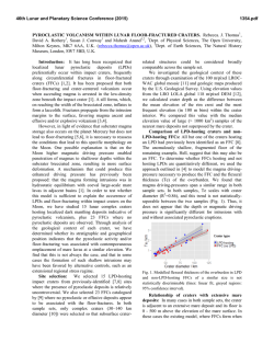
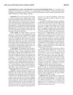
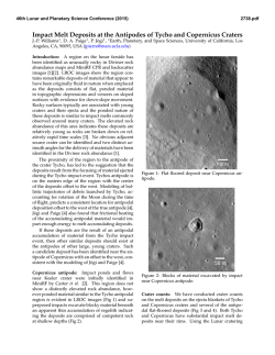
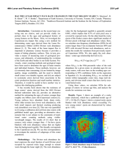
46th Lunar and Planetary Science Conference (2015)
2510.pdf
UPDATE ON THE GEOLOGIC MAPPING OF THE LUNAR SOUTH POLE QUADRANGLE (LQ-30):
EVALUATING MARE, CRYPTOMARE AND IMPACT MELT DEPOSITS. S.C. Mest1, D.C. Berman1, N.E.
Petro2, and R.A. Yingst1, 1Planetary Science Institute, 1700 E. Ft. Lowell, Suite 106, Tucson, AZ 85719-2395;
2
Planetary Geodynamics Laboratory, Code 698, NASA GSFC, Greenbelt, MD 20771. ([email protected])
Introduction: We are using recently acquired
image, spectral, and topographic data to map the
geology of the lunar South Pole quadrangle (LQ-30,
60°-90°S, 0°-±180°) at 1:2.5M scale [1-7]. The overall
objective of this research is to constrain the geologic
evolution of LQ-30 with specific emphasis on
evaluation of a) the regional effects of impact basin
formation, and b) the spatial distribution of ejecta, in
particular resulting from formation of the South PoleAitken (SPA) basin and other large basins. Key
scientific objectives for this map area include: 1)
Determining the geologic history of LQ-30 and
examining the spatial and temporal variability of
geologic processes. 2) Evaluating the distribution of
volcanic materials. And 3) constraining the distribution
of impact-generated materials, and determining the
timing and effects of major basin-forming impacts on
crustal structure and stratigraphy.
Methodology: This project utilizes ArcGIS (v.
10.1) to compile and integrate image, topographic and
spectral datasets to produce a geologic map of LQ-30.
The study uses the Lunar Reconnaissance Orbiter
(LRO) Wide Angle Camera (WAC) mosaic (~100
m/pixel) as its primary base to characterize geologic
units from surface textures and albedo, identify contacts
and structures, and map impact craters (D>1 km).
Additional datasets are being used to complement the
base and include mosaics (Lunar Orbiter, Clementine
UVVIS and NIR), images (LROC NAC, Clementine
UVVIS and HIRES, and Lunar Orbiter), Clementine
color ratio data, Moon Mineralogy Mapper (M3)
multispectral data, and LOLA topography.
Regional Geology: LQ-30 exhibits ~16 km of
relief. The Near Side consists predominantly of cratered
highlands, is more heavily cratered and displays higher
elevations than the Far Side. This difference is due to
the overwhelming presence of SPA, which encompasses
nearly all of the far side map area (Figure 1).
SPA is the largest (D=2600 km, ~18 km deep) and
oldest (pre-Nectarian) impact basin confidently
identified on the Moon [8-10]. Models suggest that SPA
formed by an oblique impact that excavated material
from the upper crust [11,12] to the lower crust or upper
mantle [13,14]. Numerous multispectral datasets show
enrichment in mafic materials [15-19] and LP-GRS data
show enhancements in both Fe and Th [20-23] within
the basin relative to the surrounding highlands. The
materials exposed within SPA, such as in central peaks
or in crater walls, are used to estimate the composition
of the lower crust/upper mantle.
Mapping Progress: We are currently focusing our
mapping efforts on the floors of impact basins and
craters and within portions of the intercrater plains that
exhibit relatively flat surfaces in order to characterize
the nature of these materials using image, spectral and
topographic datasets.
LQ-30 hosts all or part of 46 impact features greater
than 100 km in diameter, craters that would have
significantly affected the structure of the crust and
redistributed large amounts of material across the
surface [7]. Impact craters display morphologies
ranging from simple to complex [7-9,24] and most
contain floor deposits distinct from surrounding
materials. Most of these deposits, especially for craters
less than ~50 km in diameter, display moderate to bright
floor materials with little to no surface expression; these
materials likely consist of impact melt, possibly mantled
by ejecta from nearby craters, that has been wellgardened. These higher albedo deposits also tend to
contain a higher density of superposed impact craters.
Mare Deposits: Most deposits on crater and basin
floors exhibit moderate to low albedos with relatively
smooth surfaces. Potential mare deposits are found on
the floors of several of the larger impact craters (e.g.,
Antoniadi, Hausen, Klaproth, Moretus, and Amundsen)
and basins (e.g., Schrodinger, Bally, Poincare, Planck,
and Australe) within the map area [e.g., 6-9,25-27].
Although some deposits may be mantled by ejecta from
younger impact events, the lower albedo of these
materials, as well as their association with other features
such as floor fracturing, dome-shaped or conical
features suggests a volcanic origin.
For example, volcanic materials within Schrödinger
are concentrated inside the basin’s peak ring, display a
smooth, featureless, low albedo surface, and are more
mafic relative to other Schrödinger plains materials [6].
In addition, a sinuous rille is observed in association
with the mare [5-7]. Schrödinger also contains a small
(D=5 km) well-preserved ovoidal cone in the eastern
part of the basin, just inside the peak ring. The cone
displays ~500 m of relief above the surrounding plains
and is ~400 m deep from its floor to its rim [6]. The
cone has been characterized as a "maar" crater [25] and
a "dark-halo crater" (DHC) [26], and has been identified
as the source of pyroclastic eruptions [25,26].
Antoniadi Crater: Antoniadi crater (D=150 km;
69.5°S, 172°W) is unique on the Moon in that it is the
only lunar crater that contains both a peak ring and a
central peak, placing it morphologically between impact
craters and multi-ring basins [8,9]. It contains the lowest
elevations on the Moon (-8.5 km), which may provide
access to lower crustal/upper mantle materials via its
central peak and peak ring. Its floor deposits consist of
46th Lunar and Planetary Science Conference (2015)
dark smooth material near the center of the crater, and
brighter more rugged material between the peak ring
and crater wall [7,28]. Recent mapping shows that the
dark material embays the rugged material, as well as the
peak ring and central peak. The rugged material likely
includes impact melt. Superposition relationships
indicate the dark material was emplaced after the rugged
material and may consist of mare [7].
Mare Australe: Mare deposits are found on the
floor of the proposed Australe basin along the eastern
limb near the northern edge of the map area (~62°S,
90°E). These deposits are dark and smooth in
appearance, but some are brighter and more rugged
suggesting they are older and have been modified since
their emplacement by (1) mantling by ejecta, (2) mixing
by subsequent impacts, and/or (3) gardening and
regolith development [7,8].
Intercrater plains: Several areas of intercrater
plains also exhibit similar morphologic characteristics
as crater- and basin-filling materials, such as moderate
to low albedo, and relatively smooth surfaces. The
origins of these materials are more difficult to determine
due to burial by ejecta from nearby impacts, but we are
analyzing the medium-resolution LROC WAC and
high-resolution LROC NAC images, as well as M3
spectral data to evaluate the origin these materials.
2510.pdf
References: [1] Mest, S.C. (2007) LPSC XXXVIII, #1842.
[2] Van Arsdall, L.E. and S.C. Mest (2008) LPSC XXXIX,
#1706. [3] Mest, S.C. and L.E. Van Arsdall (2008) NLSI LSC,
NASA ARC, #2089. [4] Mest, S.C. (2008) GSA Joint Annual
Mtg., #324-3. [5] Mest, S.C. (2009) Ann. Mtg. of Planet.
Geol. Mappers, San Antonio, TX. [6] Mest, S.C. (2010) GSA
Sp. Paper 447, SPE477-04. [7] Mest, S.C. et al. (2010) LPSC
XLI, #2363. [8] Wilhelms, D.E. et al. (1979) USGS MISM I1162, 1:5M scale. [9] Wilhems, D.E (1987) USGS Prof. Pap.
1348. [10] Spudis, P.D. et al. (1994) Science, 266, 1848-1851.
[11] Schultz, P.H. (1997) LPSC, XXVII, #1259. [12] Schultz,
P.H. (2007) LPSC, XXXVIII, #1839. [13] Melosh, H.J. (1989)
Impact Cratering, 245 pp. [14] Cintala, M.J. and R.A.F.
Grieve (1998) Met. and Planet. Sci., 33, 889-912. [15] Belton,
M.J.S. et al. (1992) Science, 255, 570-576. [16] Head, J.W. et
al. (1993) JGR, 98, 17,149-17,182. [17] Lucey, P.G. et al.
(1998) JGR, 103, 3701-3708. [18] Pieters, C.M. et al. (1997)
GRL, 24, 1903-1906. [19] Pieters, C.M. et al. (2001) JGR,
106, 28,001-28,022. [20] Lawrence, D.J. et al. (1998) Science,
281, 1484-1489. [21] Lawrence, D.J. et al. (2002) New Views
of the Moon, Europe, 12-14. [22] Lawrence, D.J. et al. (2002)
JGR, 107, doi:10.1029/200lJE001530. [23] Jolliff, B.L. et al.
(2000) JGR, 105, 4197-4216. [24] Wood, C.A. and L.
Andersson (1978) Proc. Lunar Planet. Sci. Conf., 9th, 36693689. [25] Shoemaker, E.M. et al. (1994) Science, 266, 18511854. [26] Gaddis, L.R et al. (2003) Icarus, 161, 262-280. [27]
Kramer, G.Y., et al. (2013) Icarus, 131-148. [28] Dominov,
E. and S.C. Mest (2009) LPSC, XL, #1460.
Figure 1. Geologic map of the lunar south pole quadrangle, LQ-30.
© Copyright 2026