
A Case Study in the Humorum Region of the Moon
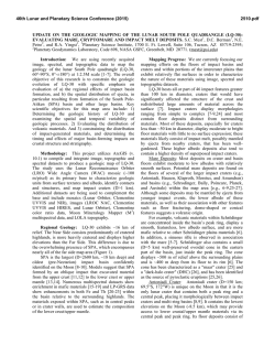
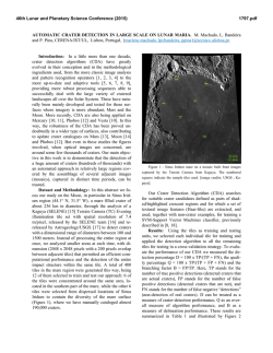
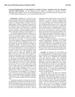
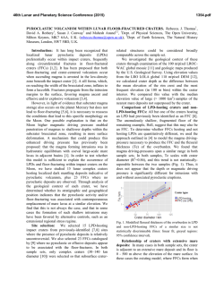
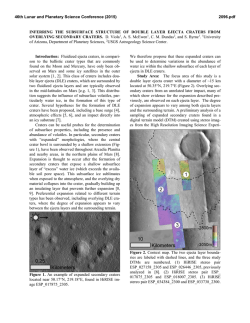
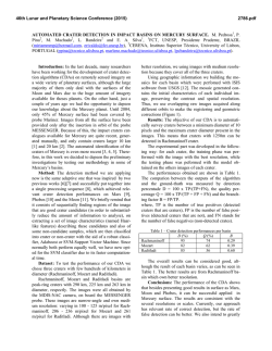
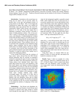
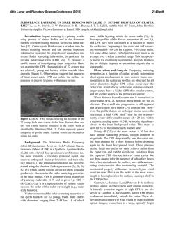
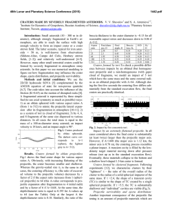
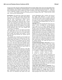
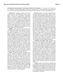
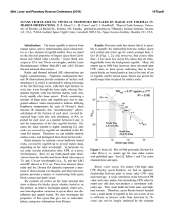
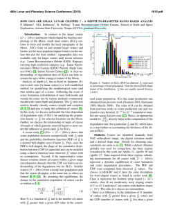
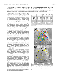
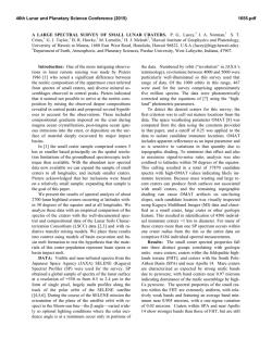
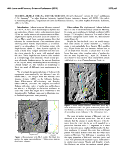
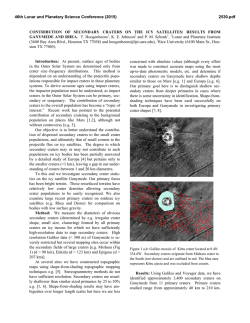
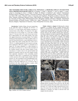
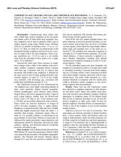
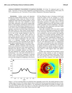
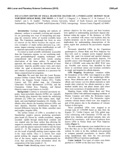
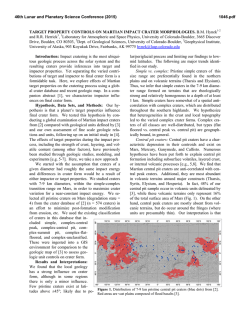
46th Lunar and Planetary Science Conference (2015) 2808.pdf THE COMPLEXITY OF CRYPTOMARIA: A CASE STUDY IN THE HUMORUM REGION OF THE MOON. I. Antonenko, Planetary Institute of Toronto, 197 Fairview Ave. Toronto, ON M6P 3A6, Canada ([email protected]). Introduction: Lunar cryptomaria represent surface volcanic materials that are obscured by ejecta from subsequent impact events. These deposits provide information on the thermal and volcanic history of the Moon, specifically information on the timing, sequence, and flux of the earliest lunar volcanism, which may be missing from the visible mare record. Recent work [1, 2] on global cryptomare estimates has renewed attention on these features. However, work done since cryptomaria were first studied [3, 4, 5] has provided a greater understanding of the complexity of cryptomaria and the craters that expose them. This complexity is highlighted in a study of the Humorum cryptmare region of the Moon. Method: The Humorum region of the Moon (290325° Lon, 7-40°S Lat) was studied using a variety of fused data sets: Lunar Orbiter [6], Clementine multispectral data [7], LOLA topography [8], LROC NACs [9], GRAIL Bouger gravity [10], and lunar geologic maps [11]. Iron abundance maps were derived from the Clementine data [12] and spectra of fresh mafic materials were identified using an automated algorithm [13]. Spectra with high albedos (indicative of plagioclase [14]) and short wavelength 1m absorption features (indicative of noritic lithologies [15]) were removed, leaving only those spectra that conservatively indicate basalt lithologies. A colour-shaded grid of LOLA data was used to visually highlight topography. All data was projected and fused into a single layered data cube. Previously identified maria were extracted from the published maps [11] for clarity. Craters that expose basaltic materials beynd the known maria were identified, using the criteria of [16]. Results: Figure 1 shows a map of iron abundance, known mare areas, identified basaltic spectra, and basalt-exposing craters. High-accuracy mapping of the mare units illustrates numerous areas of high iron signatures outside mapped mare units. The presence of basalt-exposing craters in near-mare areas supports the hypothesis that many local maria extent further than originally mapped. Figure 2 shows Bouguer gravity. A total of 71 basalt-exposing craters were identified, ranging in size from 2-100 km. Some are classic dark-haloed craters, with a low albedo halo that formed when buried basaltic material was excavated and emplaced on top of higher albedo material. Other craters, however, are not so simple. Some excavate only streaks of mafic-rich materials. Others expose a layer of basaltic material on their slopes. Figure 1: Humorum study area. Basemap, combined LO and LOLA; overlay, Clementine FeO; hatched areas, mapped mare; red squares, auto ID'ed basalt spectra; yellow dots, basalt-excavating craters. Boxes show Figure 2-4 locations. Sirsalis Crüger Humorum Figure 2: Bouguer gravity of the Humorum study area. Basemap and annotations as in Figure 1. One such prominent crater is Clausius (Figure 3), located to the southwest of Mare Humorum. Clausius is roughly 30 km in diameter, has a flat floor, a mapped mare patch in the centre, and it's ejecta has been inundated by later volcanic flows. The interior slopes of this crater clearly show a basaltic layer in FeO maps, though this layer is only hinted at in LROC NAC images. Based on FeO and LOLA data, this mafic layer is estimated to be about 400 m thick. It is 46th Lunar and Planetary Science Conference (2015) perched ~800 m above the crater floor and is buried by about 400 m of overlying ejecta. At this distance from Orientale (~1400 km), thE basin's ejecta is expected to be at most 200 km. Thus, other impacts must have contributed to the thickness of the overlying layer, including Clausius itself. A number of basalt-exposing craters are located on kipukas and other topographically high features in and around the mapped mare areas. One example is the ejecta around Billy and Hansteen craters (which have diameters on the order of 50 km). Here, three craters that excavate basalts are located on elevated ejecta that was left un flooded by subsequent volcanic flows (Figure 4). These craters (sized 2-6 km in diameter) must be excavating basalt from beneath the ejecta of Hansteen and Billy, at a depth of about 200 m. Meanwhile, the ejecta of Hansteen and Billy shows little to no mafic signature, indicating that the substrate at their excavation depths (on the order of 4 km) is mafic poor. In contrast, Letronne crater to the north of Mare Humorum shows a very strong iron signature in it's ejecta deposit. Letronne is 120 km in diameter, and has been mostly flooded by subsequent volcanic activity. If the mafic signature of Letronne's ejecta truly indicates that it is excavating basalts, then mafic materials may be located as deep as 7 km below the surface (Letronne's depth of excavation). A number of positive gravity anomalies were identified in the study region. One sprawling anomaly, located north-west of Mare Humorum, which corresponds roughly with elevated FeO values, is not related to topography. These kinds of gravity anomalies have been used by [1] to estimate thicknesses on the order of 1000-1500 m for nearby cryptomaria (though not for the Humorum region as yet). Another positive gravity anomaly is seen in the topographic basin located between Crüger and Sirsalis craters. This basin has been previously identified by [17] and contains arcuate mare deposits on the basin floor as well as the Crüger mare. One basalt- Figure 3: Clausius crater. Basemap, LO; overlay, Clementine FeO. 2808.pdf excavating crater (~5 km in diameter) is located in this area. Rugged deposits, on the scale of LOLA data resolution, can be seen in the colour-shaded topography grid, as would be expected for Orientale ejecta. This region is on the order of 1000 km from Oriental, so Orientale ejecta deposits are expected to be roughly 200-500 m thick. It is, therefore, possible, that the observed basalt exposing crater is tapping beneath the Orientale. However, since other, similar-sized craters in the region show no basalt-exposing signatures, a shallow cryptomare patch is more likely. Discussion: Cryptomare deposits have the potential to be extremely complex. In the Humorum area, we have shown that volcanic deposits can have multiple layers, each interleaved with tick deposits of nonbasaltic ejecta material. Caution must, therefore, be employed when estimating cryptomare thicknesses. References: [1] Sori M.M. (2014) LPSC 44, Abstract #2755. [2] Whitten J.L. and Head J.W. (2015) Icarus 247, 150171. [3] Head J.W. and Wilson L. (1992) Geochem. Cosmochim. Acta 56, 2144-2175. [4] Antonenko I. et al. (1995) EMP 69, 141-172. [5] Antonenko I. (1999) Thesis, Brown Univ. p309. [6] Bowker D.E. and Hughes J.K. (1971) NASA Spec. Pub. 206. [7] Nozette S. et al. (1994) Science 266, 1835-9. [8] Neumann G.A. (2010) LRO-L-LOLA-4-GDR-V1.0, NASA Planetary Data System (PDS). [9] Robinson, M. (2009) LRO MOON LROC 5 RDR V1.0, LRO-L-LROC-5-RDR-V1.0, NASA Planetary Data System (PDS). [10] Kahan D.S. (2013) GRAIL Moon LGRS Derived Gravity Science Data Products V1.0, GRAIL-L-LGRS-5-RDR-V1.0, NASA Planetary Data System, 2013. [11] Karlstrom, T.N.V. (1974) Map I-823, USGS, Washington, DC. Marshall, C.H. (1963) Map I-385, USGS, Washington, DC. McCauley, J.F. (1973) Map I-740, USGS, Washington, DC. Saunders R.S. and Wilhelms D.E. (1974) Map I-824, USGS, Washington, DC. Scott, D.H. et al. (1977) Map I-1034, USGS, Washington, DC. Titley, S.R. (1967) Map I-495, USGS, Washington, DC. Wilshire, H.G. (1973) Map I-755, USGS, Washington, DC. [12] Lucey P.G. et al. (2000) JGR 105, E8, 20,297-20,305. [13] Antonenko I. and Osinski G.R. (2011) PSS 59, 715-721. [14] Pieters C.M. et al. (1993) JGR 98, E9, 17,127-17,148. [15] Adams J.B. (1974) JGR 79, 4829-4836. [16] Antonenko I (2013) LPSC 43, Abstract #2607. [17] Frey H. (20111) GSA Spec. Pub. 477, 53-75. Figure 4: Craters Hansteen (top) and Billy (bottom). Data layers as for Figure 1. Figure 5: Letronne crater, with unflooded ejecta to the south. Data layers as for Figure 1.
© Copyright 2026