
CRATER MORPHOLOGY IN THE PHOENIX LANDING ELLIPSE
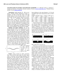
46th Lunar and Planetary Science Conference (2015)
2511.pdf
CRATER MORPHOLOGY IN THE PHOENIX LANDING ELLIPSE: INSIGHTS INTO NET EROSION
AND ICE TABLE DEPTH. E.Z. Noe Dobrea1,2 and C.R. Stoker2, C.P. McKay2, A.F. Davila2,3, M. Krčo4.
1
Planetary Science Institute, Tucson, AZ, 85719 ([email protected]); 2NASA Ames Research Center, Mountain View,
CA; 3SETI Institute, Mountain View, CA; 4Cornell University, Ithaca, NY.
Introduction: Icebreaker [1] is a Discovery class
mission being developed for future flight opportunities.
Under this mission concept, the Icebreaker payload is
carried on a stationary lander, and lands in the same
landing ellipse as Phoenix. Samples are acquired from
the subsurface using a drilling system that penetrates
into materials which may include loose or cemented
soil, icy soil, pure ice, rocks, or mixtures of these. To
avoid the complexity of mating additional strings, the
drill is single-string, limiting it to a total length of 1 m.
The scientific rationale behind the landing site selection for the Icebreaker mission lies in the presence
of an easily accessible, shallow ice table. Ice is an interesting target in the search for evidence of modern
life on Mars for two reasons: 1) it can provide liquid
water when conditions of temperature and pressure are
suitable, thus allowing for biological activity; 2) icerich ground may prevent destruction of organics by
atmospheric oxidants. The ideal location on Mars to
search for biomarkers could be the ice-bearing permafrost in the northern plains [1; 2]. Here, the presence of
ice near the surface (4.6 cm deep at the Phoenix site)
provides a source of H2O. The atmospheric surface
pressure above the triple point stabilizes the liquid
phase even of pure water. Thus, all that would be required to provide liquid water activity capable of supporting life is sufficient energy to melt the subsurface
ice. This may occur periodically during high obliquity
periods (HOPs), when solar insolation near polar latitudes is higher than at present. Such HOPs, which have
a recurrence time of c.a. 125 kyr , have reached obliquities of up to 35º over the past 3 million years, and up
to 45º at earlier epochs [3]. Such high obliquities can
result in peak surface temperatures above 0ºC in the
high northern latitudes at obliquities >40º, and temperatures above –20ºC for an obliquity as low as 35º
[4]. [5] showed that when obliquity is 45º melting can
occur 50 days per year in the high northern latitudes.
Hence, ice-bearing permafrost in the northern plains of
Mars could be a site of recent habitability compatible
with the survivability of radiation-tolerant microorganisms.
Of particular importance to landing site selection is
the development of a framework with which to understand the depositional history of the region. In particular, we seek to better understand the distribution of ice
as well as the erosional history of the region. If the site
has been a net depositional site and over a meter of
sediment has been deposited since the last period of
habitability, the current Icebreaker sampling system
will not be capable of accessing the sediments that
were exposed to liquid water. On the other hand, if the
site has experienced net erosion of over a meter, then
these sediments will have been removed. Although the
former scenario presents a significant obstacle to mission success, the latter is not necessarily a problem,
and may even be preferable, as erosion may expose
deeper (and therefore more protected) sediments associated with previous periods of habitability. Hence, we
seek to address the question: has the terrain within the
proposed landing site been a site of net erosion or
deposition within the last 5 Myr?
In order to address this question, we performed an
extensive morphological examination of the craters
within the landing ellipse. We searched for the freshest craters of varying sizes and estimated the net level
of deposition since their formation by searching for
ejecta blocks and measuring the sizes of these blocks.
The age of these craters was estimated from the crater
production rates constrained by previous studies [6; 7].
Procedure: We inspected all of the HiRISE and
CTX images acquired in this region to date, covering
an area of 4000 km2 that included the Phoenix landing
ellipse, with the aim of identifying and cataloguing
every crater within the ellipse. The ice-cemented
ground and associated periglacial processes affect the
appearance of craters over time, and allow to distinguish fresh craters from modified ones. Fresh craters
were identified by the presence of a bowl-shaped depression and potentially a rim. Modified craters were
identified by the presence of concentric and/or radial
fracture patterns, or circular areas corresponding to
clearing pre-existing slow-forming patterns (e.g., boulder piles, 30-meter polygons).
Once all the craters in the region were identified,
we classified the craters on the basis of size, degree of
degradation, target morphology, and the presence of
ejecta blocks. The degree of degradation was inferred
from the state of the crater floor, rim, and ejecta as
well as the degree of pattern development and boulder
sorting. From these characteristics, we identified the
freshest craters of each size grouping and assessed
these for the presence of ejecta boulders at HiRISE
scales. Ejecta boulders were distinguished from nonejecta boulders by their distribution with relation to the
46th Lunar and Planetary Science Conference (2015)
crater. Ejecta boulders increase in spatial density with
proximity to the crater, and may be distributed radially
away from the crater.
Results: We identified over 2000 craters in the
4000 km2 region of interest and binned them into
groups on the basis of crater size and degree of modification. We found that it is fairly straightforward to
identify a pattern of modification for each range size.
Modification of craters ranging in size from ~100 m to
a couple of km typically involves the loss of relief of
both the rim and the crater bowl, as well as the formation of a network of co-centric and radial fractures or
ridges within the former bowl. Because bowls disappear more readily than rims, we attributed the loss of
relief to the solifluction of ice-rich soil. On the other
hand, craters smaller than 100 m typically exhibit loss
of their bowl by in-filling with smooth, higher-albedo
material inferred to be a combination of frost and dust.
Overall, we found that ejecta boulders are visible down
to the resolution limit of HiRISE (~30 cm/pixel) for
most craters larger than 200-300 m in diameter. Absence of ejecta boulders is typically associated to the
most modified craters (i.e., craters with no apparent
relief and craters whose interiors are covered with
boulder piles), and craters smaller than about 200-300
meters (Fig. 1). According to [8], craters 250 meters
and larger form roughly every 5 Myrs in a 4000 km2
area. Hence, it is inferred here from the identification
of ejecta boulders down to the limit of resolution of
HiRISE for all but the oldest and smallest craters that
the region not has experienced a net deposition of 1
meter or more since the formation of these craters.
The absence of ejecta blocks in most craters
smaller than 200-300 meters is particularly intriguing
as it suggests impacts onto a layer of ice-cemented,
friable, or unconsolidated soil approximately 20-30 m
thick [9]. This layer likely overlies a basement of
stronger material that is only exposed by larger impactors, and does generate ejecta blocks in most larger
craters (>300 m). Our inferred stratigraphy in his region is consistent with observations from SHARAD
[10], which identifies a radar return at depths of 15-66
meters in the Phoenix landing ellipse. The presence of
significant amounts of water ice, inferred from modeling and observations by GRS and the Phoenix lander
[11], could explain the lack of ejecta boulders as due to
sublimation of cementing ice post-impact.
2511.pdf
References: [1] McKay et al. (2013) Astrobiology,
13(4) 334-353. [2] Stoker et al. (2010) JGR 115,
E00E20. [3] Levrard et al. (2004) Nature 431, 10721075. [4] Costard et al. (2002) 293, 110-113. [5]
Richardson and Mischna (2005) JGR E3. [6] Malin et
al. (2006) Science 314, 1573. [7] Daubar et al. (2013)
Icarus 225, 506-516. [8] Hartmann (2005) Icarus 174,
294-320. [9] Mellosh (1996) Impact Cratering. [10]
Putzig et al. (2014) JGR 119, 1936-1949. [11] Mellon
et al. (2009) JGR, 119, 1936-1949.
Figure 1. Two craters located about 2.6 km apart and
differing in size by 100 meters. Top: Fresh-looking,
200 meter crater exhibits a clear bowl shape and
smooth, higher albedo mantling deposit in its interior.
Boulders around the crater do not exhibit an increase in
concentration with proximity to crater, suggesting that
they are not ejecta. Sun is from the top. Bottom:
Modified 300 meter crater exhibits a flat, cocentrically fractured floor and clear evidence for ejecta
boulders.
© Copyright 2026