
The Far-UV Albedo of the Moon as a Probe of the Lunar Cryosphere
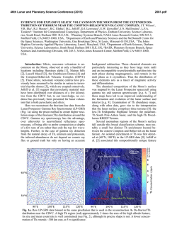
46th Lunar and Planetary Science Conference (2015)
2213.pdf
The Far-UV Albedo of the Moon as a Probe of the Lunar Cryosphere: LRO Lyman Alpha Mapping Project
(LAMP) Latest Results. K. D. Retherford1, T. K. Greathouse1, G. R. Gladstone1, A. R. Hendrix2, K. E. Mandt1, A.
F. Egan3, D. E. Kaufmann3, P. O. Hayne4, M. A. Bullock3, S. A. Stern3, J. Wm. Parker3, M. W. Davis1, D. M. Hurley5, W. R. Pryor6, P. D. Feldman7, C. Grava1, J. Mukherjee1, P. Mokashi1, C. M. Seifert1, C. J. Seifert1, and M. H.
Versteeg1; 1Southwest Research Institute, San Antonio, TX ([email protected]), 2Space Sciences Institute, Tucson, AZ, 3Southwest Research Institute, Boulder, CO, 4Jet Propulsion Laboratory, Pasadena, CA, 5Johns Hopkins
University Applied Physics Laboratory, Laurel, MD, 6Central Arizona University, Coolidge, AZ, 7Johns Hopkins
University, Baltimore, MD.
Abstract. Far ultraviolet (far-UV) albedo maps are
obtained using the Lunar Reconnaissance Orbiter
(LRO) Lyman Alpha Mapping Project (LAMP)’s innovative nightside observing technique [1]. Similar
dayside FUV maps obtained using the more traditional
photometry technique with the Sun as the illumination
source are very complementary. LRO-LAMP measurements provide a unique perspective on the lunar
"hydrological cycle," connecting the surface abundance of water frost trapped in the Moon's cryosphere
to volatile transport processes involving the lunar exosphere.
Introduction. The LRO-LAMP is a highly capable
UV imaging spectrograph that addresses how water is
formed on the Moon, transported through the lunar
exosphere, and deposited in permanently shaded regions (PSRs)[2,3]. Importantly, the nightside imaging
technique allows us to peer into the PSRs near the
poles, and determine their UV albedos. LAMP data
products include nightside and dayside brightness
maps over specific wavelength ranges, and similarly
constructed albedo maps (i.e., brightness maps normalized by the varying illumination). Lyman-α, on-band
and off-band maps (i.e., on and off the water frost absorption band at ~165 nm) are useful for constraining
the abundance of surficial water frost [1,4,5].
Key Results. Global nightside and dayside maps
are now available, divided (at ±60° latitude) into polar
and equatorial regions with stereographic and
equirectangular projections, respectively. Additionally,
new spectral image cube maps have been created for
several regions of interest with 2 nm resolution.
LAMP FUV albedo measurements indicate ~1-2%
surface water frost areal-mixing abundances in a few
PSRs based on spectral color comparisons, and we find
that many PSRs may have porosities of ~0.7 based on
relatively low albedos at Lyman-α [1,5]. The FUV
albedo maps reveal lower albedo regions within the
coldest PSR regions, determined with correlative analyses using LRO-Diviner maps [5]. Mandt et al., this
meeting, will present updated analyses of the PSR reflectance measurements including a search for albedo
changes on monthly timescales.
Global dayside FUV albedo maps enable comparisons between the nightside and dayside photometry
techniques to help validate the use of Lyman-α and
starlight as illumination sources. Analysis of dayside
spectra for selected regions complement the dayside
maps, and are used to investigate space weathering and
hydrated surface signatures [6]. A lab study of the
FUV reflectance properties of Apollo samples, lunar
simulants, and water ice is underway to further characterize the UV reflectance techniques. The far-UV spectral inversion property of the lunar albedo discovered
by the Apollo 17 UVS is confirmed with the LAMP
dataset [4], and Hendrix et al., this meeting, report that
swirl regions show a UV-darkening, perhaps in response to changes in space weathering processes within these regions.
Future Investigations. The LRO second extended
science mission continues LAMP observations through
September 2016. More surface reflectance data (60190 nm) at a variety of incident and emission angles
will improve signal, spectral, and photometric quality
and further develop our innovative nightside UV reflectance technique for identifying surficial water frost
and determining surface porosity. Spectral image cube
maps with 2 nm resolution are computationally expensive but are now being extended to cover all regions.
LRO continues to target UV-interesting regions, including LROC imaging of key PSRs identified by
LRO/LEND and Mini-RF as potentially water-rich.
Global searches of water signatures outside of PSRs
with LAMP confirm and elucidate the findings of surface water/hydroxyl and its variability with infrared
Chandryaan-M3/Cassini-VIMS/EPOXI data [6], and
future observations emphasize improved dayside coverage and trending of high-phase dawn/dusk regions.
References [1] Gladstone, G. R. et al., Far-Ultraviolet
Reflectance Properites of the Moon’s Permanently Shadowed
Regions, J. Geophys. Res., 117, E00H04, 2012. [2] Gladstone, G. R., et al., LAMP: The Lyman Alpha Mapping Project on NASA’s Lunar Reconnaissance Orbiter Mission,
Space Sci. Rev., 150, 161-181, 2010. [3] Gladstone, G. R. et
al., LRO-LAMP Observations of the LCROSS Impact
Plume, Science, 330, 472-476, 2010. [4] Retherford, K. D., et
al., LRO/LAMP Far-UV Albedo Maps, in preparation, 2015.
[5] Hayne, P. O. et al., Evidence for Exposed Water Ice in
the Moon’s South Polar Regions from Lunar Reconnaissance
Orbiter Ultraviolet Albedo and Temperature Measurements,
submitted to Icarus, 2015. [6] Hendrix, A. R., et al., Lunar
Albedo in the Far-UV: Indicator of Hydrated Materials and
Space Weathering, J. Geophys. Res., 117, E12001, 2012.
© Copyright 2026