
Secondary Craters Associated with the Rayed Crater Zumba
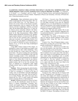
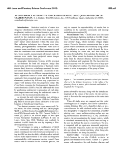
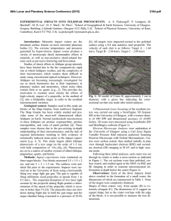
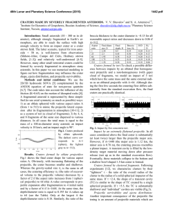
46th Lunar and Planetary Science Conference (2015)
2488.pdf
SECONDARY CRATERS ASSOCIATED WITH THE RAYED CRATER ZUMBA, DAEDALIA PLANUM,
MARS. F. C. Chuang1, D. A. Crown1, and L. L. Tornabene2, 1 Planetary Science Institute, 1700 E. Ft. Lowell Road,
Suite 106, Tucson, AZ 85719 USA; 2 Centre for Planetary Science and Exploration, Dept. of Earth Sciences,
Western University, London, ON N6A 5B7, Canada ([email protected]).
Introduction: Zumba is a 2.9 km diameter impact
crater located in Daedalia Planum (center: 28.6° N,
226.9° E), an area of elevated plains at the southern
margin of the Tharsis region. The Daedalia Planum
area is dominated by expansive lava flow fields and
also includes embayed and isolated massifs of ancient
highland materials, degraded impact crater rims, and
areas of rugged terrain [1-8]. The Zumba impact event
occurred on the lava flows, which from previous
geologic mapping were identified as part of the
Hesperian-age Tharsis Montes formation [1].
One of most distinctive features of Zumba is the
prominent rayed pattern emanating from the impact
site. In Thermal Emission Imaging System (THEMIS)
infrared data, the rays are highly distinct, with some
reaching hundreds of kilometers in length [9]. For
Zumba and several other rayed craters on Mars [9,10],
the rays correlate well with dense clusters of
secondaries that are best observed in Mars Orbiter
Camera (MOC), Context Camera (CTX), and High
Resolution Imaging Science Experiment (HiRISE)
images [9-12]. This correlation is in contrast to other
craters on Mars with ray-like patterns in thermal data
(e.g., Hale and Mojave [13,14]), but that lack dense
clusters of secondaries. Instead, these patterns
represent either ejecta rays or air-blasted surfaces. We
refer to the rays in this study as secondary crater rays.
We have recently completed detailed mapping of
Zumba secondary craters to investigate their
distribution and density as a function of distance from
the impact site. Given the young age (potentially 100
ka) [15], good state of preservation, and relatively
uniform geology of the impact region, this information
provides insight into the cratering process (e.g.,
direction and angle of impactor), a means to assess
ages derived from small crater populations [15,16] and
the spallation process on a body with an atmosphere
[17], and to gauge the volcanic compositions and
stratigraphy at the impact site and where secondary
craters formed (see [3]). Previous studies of Martian
rayed craters suggest that the Zumba impact site may
have a provided a source for Martian SNC meteorites
[3,9].
Data, Methods, and Study Region: Global 100
m/pixel THEMIS daytime and nighttime IR mosaics
were used as the primary base in studying the regional
geologic features of Daedalia Planum and crater
Zumba. The mapping area consists of the entire region
within a 200 km radius of Zumba.
Secondary crater rays, a few of which extend
further than 200 km, were first mapped using THEMIS
data. After detailed examination of the rays and other
areas within the study region, secondaries were mapped
on 5-6 m/pixel CTX images (49 total), which covered
72% of the mapping area. Secondary craters are most
often observed in groups within dark areas of the
surface, presumably due to removal of bright dust by
impact processes. In this study, only solitary and dense
groups of secondary craters (hereafter termed
secondary fields) with associated dark deposits were
mapped and stored as polygon features using ArcGIS
10.2.2 software.
Mapping Results: A total of 12,793 secondary
fields were mapped, covering a cumulative area of
2459.2 km2. Statistics for the population of secondary
fields are provided in Figure 1. The vast majority of
secondary fields (n=12,310; 96.2%) are small (0.005-1
km2). We find that small to medium-sized secondary
fields are widespread throughout the 200 km radial
area whereas larger secondary fields (10-50 km2) are
associated with and concentrated within the large
secondary crater rays.
In order to analyze the distribution of Zumba
secondaries, we divide the mapping area into eight
primary 45° sectors (Figure 2). Within each of these
sectors, we also divide the distance into 50 km
increments from the center of Zumba out to 200 km,
for a total of 32 individual sectors. Sectors with
coverage gaps occur within 100-200 km from Zumba.
For the entire study region, the percentage of area
covered by secondary fields in any given sector ranges
from ~0.095% to 19.4%. We find that the highest areal
coverages occur within 100 km of Zumba (a1-h1 & a2h2) and that beyond this, sectors c3-4, f2-3, and g2-4
exhibit the highest areal coverages due to the longest
secondary crater rays located in these areas. If we
consider each 50 km "ring" of sectors (8 sectors in
each ring, A-D in Fig. 2) around Zumba, the peak
cumulative number and greatest areal coverage of
secondaries occurs in ring B (Table 1). These values
decrease in rings C and D.
Overall, the data show that from A to D, the
average mean size of secondary fields decreases, which
is consistent with the expectation of lower numbers and
smaller sizes of secondary craters with greater distance
from the impact site. For rings A and B, the average
mean sizes are much larger (minimally ~3.6X) than for
rings C and D. This is consistent with our earlier result
46th Lunar and Planetary Science Conference (2015)
that most secondaries are located within 100 km of the
impact site.
We have also made preliminary estimates of the
crater density for mean-sized secondary fields (0.193
km2) in the study area. Of the nine secondary fields
selected (within ±500 m2 of the mean), we count 5-18
craters for a density of ~25.9-93.3/km2. Assuming that
this density is solely due to the Zumba impact,
~63,693-229,443 secondary craters were produced.
These values are ~1-3 orders smaller than estimates of
secondary craters for the 10 km diameter rayed crater
Zunil [10,11]. However, Zunil's population may be an
overestimate due to the overlap of secondary craters
produced by crater Corinto [18].
References: [1] Scott and Tanaka (1986) USGS Misc.
Invest. Ser. Map I-1802-A. [2] Dohm et al. (2001) USGS
Misc. Invest. Ser. Map I-2650. [3] Lang et al. (2009) JVGR,
185, doi:10.1016/j.jvolgeores.2008.12.014. [4] Scott (1981)
USGS Misc. Invest. Ser. Map I-1274. [5] Scott and Tanaka
(1981) USGS Misc. Invest. Ser. Map I-1281. [6] Crown et al.
(2011) LPSC 42, Abstract #2353. [7] Crown et al. (2013)
LPSC 44, Abstract #2499. [8] Bleacher et al. (2007) JGR,
112, doi:10.1029/2006JE002873. [9] Tornabene et al. (2006)
JGR, 111, doi:10.1029/2005JE002600. [10] McEwen et al.
(2005) Icarus, 176, 351-381. [11] Preblich et al. (2007) JGR,
112, doi:10.0129/2006JE002817. [12] Calef et al. (2009)
JGR, 114, doi:10.1029/2008JE003283. [13] Williams and
Malin (2008) Icarus, 198, doi: 10.1016/j.icarus.2008.07.013.
[14]
Jones
et
al.
(2011)
Icarus,
211,
doi:10.1016/j.icarus.2010.10.014. [15] Hartmann et al.
(2010) Icarus, 208, doi:10.1016/j.icarus.2010.03.030. [16]
Hartmann
(2007)
Icarus,
189,
doi:10.1016/j.icarus.2007.02.011. [17] Melosh (2001)
Impact Cratering, 245 pp. [18] Golombek et al. (2014)
LPSC 45, Abstract #1470.
2488.pdf
Table 1. Statistics for areal coverage by Zumba secondary
fields in sector rings A-D*.
Ring count
min
max
med
mean±stdev
(n)
(km2) (km2) (km2)
(km2)
A
354
0.0030 6.38
0.133
0.336±0.635
B
490
0.0015 11.1
0.065
0.284±0.800
C
383
0.0037 2.81
0.026
0.077±0.222
D
386
0.0017 2.85
0.023
0.049±0.155
* see fig. 2 for defined sector rings
Figure 1. Histogram of areal coverage of Zumba secondary
fields showing high positive skew (~18). Approximately
96% of secondary fields are 0.005-1 km2 in size.
Figure 2. Azimuthal distribution of mapped
Zumba secondary fields (black polygons). Hotcool colors represent the percent area covered by
secondaries in each sector (45° circumferential
arc and 50 km wide from the crater center, 32
total). Highest densities are within 100 km of
Zumba and in sectors containing the longest rays
(c3-4, f2-3, g2-4). Statistics for each 50 km
"ring" of eight sectors (A-D) are shown in Table
1. Background composed of THEMIS day IR
base mosaic with overlying CTX images.

© Copyright 2026