
PHLEGRA MONTES, MARS: CHRONOLOGY AND DENUDATION
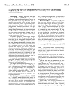
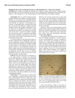
46th Lunar and Planetary Science Conference (2015)
1371.pdf
P H L E G R A MONTES, MARS: CHRO N O L O G Y A N D D E N U DAT I O N R AT E S
S. van Gasselt1 , A.-P. Rossi2 , C. Orgel1,3 , J. Schulz1 . 1 Freie Universität Berlin, Department of Earth Sciences,
D–12249 Berlin, Germany ([email protected]); 2 Jacobs University Bremen, Earth and Space Sciences,
D–28759 Bremen, Germany; 3 Eötvös Loránd University, Department of Geology, Budapest, 1053 Hungary.
Background: The Phlegra Montes are located north–
east of the Elysium rise (165◦ E, 29.5–51.0◦ N) and form
a 1,250 km long topographically well-pronounced arcuate ridge composed of Hesperian to Noachian–aged
remnant massifs [1] with associated debris aprons and
lineated valley fill features (fig. 1). Considered to be of
endogenic tectonic origin in earlier work [2], the Phlegra
Montes have recently been interpreted as unit composed
of degraded Hesperian–aged (3.650.04
0.06 Gyr (eHt) and
3.710.06
0.10 Gyr (lHt)), and Noachian- to Hesperian–aged
0.08
(3.770.05
0.07 –3.910.18 Gyr HNt) material of potentially volcanic origin pre–dating the Hesperian plains–forming
lowland material [1]. Younger mass–wasting material
covering these remnants is considered to be of Hesperian
age[1].
The Phlegra Montes cover more than twenty degrees
in latitude and form a complex system of isolated hills,
ridges and small basins that provide insight into large
climate-controlled geomorphologic settings and processes on Mars. The Phlegra Montes form a longitudinally confined traverse through climatic zones that are
known to host features indicative of ground ice and/or
even glacial ice [3, 4]. Despite such value, the region has
received little attention and has been revisited only relatively recently when radar–data interpretations provided
new arguments in favour of extensive glaciation [5, 6, 7],
and local geomorphologic studies provided reasons to
believe that the region was once covered by extensive
ice sheets [8, 9] several hundred Myr ago. Our study is
concentrated on a systematic survey covering detailed
age distributions of surface units as function of latitude in order (a) to obtain statistically representative and
latitudinally dependent age estimates—in particular as
there are discrepancies with respect to the youthfulness
of local surface–ages [9, 1]. Furthermore, the survey
is carried out (b) to derive upper denudation–rate estimates for mass–wasting units under the assumption
of hyper–arid climate conditions favouring periglacial
denudation. We expect that latitudinal trends will potentially be observable within the limits of accuracy of
morphometric measurements and age determinations if
young–Amazonian climate variations control formation
of icy aprons on Mars.
Approach and Analysis: Data analysis is based on
high–resolution image data obtained by the MRO Context Imager (CTX) [10] and MGS Mars Observer Camera (MOC) [11] instruments and is complemented by
med- to high–resolution context images from the MEx
High Resolution Stereo Camera (HRSC) [12, 13] and the
MO THEMIS (VIS/IR) instruments [14]. Topography is
derived using (a) gridded MGS Mars Orbiter Laser Altimeter (MOLA) data [15, 16], (b) photogrammetrically–
derived stereo information from HRSC [17, 18] (absolute and regional scales) and (c) photoclinometricallyderived information using observation– and illumination–
geometries (relative and local scales).
Our primary aim is the systematic assessment of representative surface ages using impact–crater size–frequency
statistics with recent chronology models and definition of
the Martian impact-crater production function described
in [19]. Crater–based age determinations are based on
areas that we considered as geologically distinct and homogeneous, and that were formed by a distinct process.
Diameter–sizes are determined using the ArcGIS CraterTools extension by [20]. Analysis of impact–crater size–
frequency statistics and derivation of model ages were
carried out using Craterstats II [21] using recently summarised, updated and refined methodological approaches
described by [22, 19, 23]. Data on systematic age determinations are supplemented by selected morphometric
Figure 1: Hillshade topography (MOLA) and geologic
units as published by[1]. Generalized contours are in
dashed (500 m) and solid white lines (1000 m) based on
MOLA GDR [16].
46th Lunar and Planetary Science Conference (2015)
measurements in order to estimate denudation ages and
rates, according to the methodological framework described in [24], allowing comparison with rover–based
estimates [25, 26]. However, rates are difficult to assess
owing to considerable uncertainties regarding the formation age of remnant massifs and limited knowledge and
data on extents of aprons.
Results: Ages have been measured for 36 areas over
the study region (fig. 2). Ages of volcanic units in the
south are comparable to recent published measurements
0.07
and are in the range of 3.430.12
0.57 Gyr to 3.540.19 Gyr after
resurfacing correction. A younger signal might refer to
1371.pdf
new resurfacing events, e.g. new volcanic emplacements
as subdued impact crater suggest. It remains noteworthy
that resurfacing has been a continuing process indicated
by flattened crater–size frequency distributions. Significant resurfacing events took place around 2.090.19
0.19 for the
southern basin unit and at 1.060.17
Gyr
for
intra-ridge
0.17
units. Lineated valley fill areas in the central study region
(fig. 2) show several age signals, as old as 3.5 Gyr for the
underlying terrain and as young as 71 Myr for youngest
surface (comparable to previously published ages).
Measurements of denudation rates of aprons across the
overall study area indicate values of 0.01–0.02 mm ±
10−3 mm a−1 since the Hesperian–Noachian transition
which is – partially due to relief – at least one order of
magnitude higher than conventional estimates for areas
on Mars, e.g., [26]. It is conceivable that high rates indicate an interplay of (a) atmospheric deposition of ice and
flow (glacial context), and (b) denudation of hillslopes
and gravitational creep of ice and debris (periglacial context).
Acknowledgement: This work is partially supported by the
National Space Administration with means of the Federal Ministry for Economic Affairs and Energy (grant 50QM1301).
Figure 2: Main geomorphic and geologic units superimposed by remnant distribution (white boxes + density
plot in red and 1–σ distribution (hachured)). Two selected areas with associated age measurements are marked
in bright red.
References: [1] K. L. Tanaka et al. 2014. U.S. Geol.
Surv. Sci. Inv. Map. 3292. [2] J. M. Moore. 1985. Lun. Planet.
Sci. Conf. Abs., XVI: 573–574.
[3] M. H. Carr & G. G.
Schaber. 1977. J. Geophys. Res.. 82(28): 4,039–4,054. [4] S.
W. Squyres. 1979. J. Geophys. Res., 84(B14): 8,087–8,096.
[5] A. Safaeinili et al. 2009. Lun. Planet. Sci. Conf. Abs., XL:
#1988.
[6] J. W. Holt et al. 2008. Science, 322(5905):
1235–1238. [7] J. J. Plaut et al. 2009. Geophys. Res. Lett.,
36(2): L02203. [8] A. Kress et al. 2010. Lun. Planet. Sci.
Conf. Abs., XLI: #1166 [9] J. L. Dickson et al. 2010. Earth
Planet Sci. Lett., 294(3–4): 332–342. [10] M. C. Malin et al.
2007. J. Geophys. Res., 112, E05S04. [11] M. C. Malin et al.
1992. J. Geophys. Res., 97(E5): 7,699–7,718. [12] G. Neukum
et al. 2004. ESA–Spec. Pub., 1240: 17–35. [13] R. Jaumann et
al. 2007. Planet. Space Sci., 55(7–8): 928–952. [14] P. R.
Christensen et al. 2004. Space Sci. Rev., 110(1): 85–130.
[15] D. E. Smith et al. 2001. J. Geophys. Res., 106( E10):
23,689–23,722. [16] D. E. Smith et al. 2003. NASA PDS,
MGS–M–MOLA–5–MEGDR–L3–V1.0 [17] F. Scholten et al.
2005. Photogram. Eng. & Rem. Sens., 71(10): 1,143–1,152.
[18] K. Gwinner et al. 2010. Earth Planet. Sci. Lett.,
294(3–4): 506-519. [19] G. G. Michael 2013. Icarus, 226(1):
885–890. [20] T. Kneissl et al. 2011. Planet. Space Sci.,
59(11–12): 1,243–1,254. [21] G. G. Michael & G. Neukum
2010. Earth Planet. Sci. Lett., 294(3–4): 223–229. [22] G. G.
Michael et al. 2012. Icarus, 218(1): 169–177. [23] T. Platz et
al. 2013. Icarus, 225(1): 806–827. [24] S. van Gasselt et al.
2011. Geol. Soc. London Spec. Pub., 356: 43–67. [25] M. P.
Golombek et al. 2006. J. Geophys. Res., 111(E12). [26] M. H.
Carr 1992. Proc. 23rd Annual Lun. Planet. Sci. Conf. 205–206.

© Copyright 2026