
Chart application
Dr a g o n fly ®
Release 10
Installation and operation
instructions
English
Date: 08-2014
Document number: 81345-4-EN
© 2014 Raymarine UK Limited
Document and software changes
The following tables describe the main changes that have been made since the last release of both the
product software and this document.
• Applicable software version: LightHouse II — Release 10.xx
• Applicable documents: 81345–4.
• Applicable products: Dragonfly®6 / Dragonfly®7.
Document and Software changes
Description
Applicable application
Applicable chapter(s) or
section(s)
Added support for Navionics Navionics® SonarCharts™.
Chart application
• 8.11 Sonar logging
Changed internal GPS refresh rate to 5 Hz.
Tools & Settings
• GPS specification
Applicable application
Applicable chapter(s) or
section(s)
Document changes
Description
List of learning resources added to Getting Started and Technical N/A
Support chapters.
• 6.10 Learning resources
Added full details for GPS and Sonar Set-up to Tools & Settings
Chapter.
Tools & Settings
• Chapter 12 Tools &
Settings
Updated Chart application overview to include commonly used
features.
Chart application
• 8.1 Chart application
overview
Updated Sonar application overview to include commonly used
features.
Sonar application
• 10.1 Sonar application
overview
Updated DownVision™ application overview to include
commonly used features.
DownVision™ application
• 11.1 DownVision™
application overview
Added Document and Software changes table (this table) to
beginning of manual.
N/A
N/A
Description
Applicable application
Applicable chapter(s) or
section(s)
Added support for encrypted LightHouse Charts.
Chart application
N/A
Software changes
Trademark and patents notice
Raymarine, Tacktick, Clear Pulse, Truzoom, HSB, SeaTalk, SeaTalkhs, SeaTalkng, Micronet, Raytech,
Gear Up, Marine Shield, Seahawk, Autohelm, Automagic, and Visionality are registered or claimed
trademarks of Raymarine Belgium.
FLIR, DownVision, SideVision, Dragonfly, Instalert, Infrared Everywhere, and The World’s Sixth
Sense are registered or claimed trademarks of FLIR Systems, Inc.
All other trademarks, trade names, or company names referenced herein are used for identification only
and are the property of their respective owners.
This product is protected by patents, design patents, patents pending, or design patents pending.
Fair Use Statement
You may print no more than three copies of this manual for your own use. You may not make any further
copies or distribute or use the manual in any other way including without limitation exploiting the manual
commercially or giving or selling copies to third parties.
Software updates
Check the website www.raymarine.com for the latest software releases for your product.
ENGLISH
Document number: 81345-4
Date: 08-2014
Product handbooks
The latest versions of all English and translated handbooks are available to download in PDF format from the website
www.raymarine.com.
Please check the website to ensure you have the latest handbooks.
Copyright ©2014 Raymarine UK Ltd. All rights reserved.
Contents
Chapter 1 Important information.......................... 7
6.6 DownVision check................................................ 42
TFT Displays ............................................................... 8
Water ingress .............................................................. 8
6.7 Shortcuts page..................................................... 43
Disclaimers ................................................................. 8
Memory cards and chart cards ..................................... 8
EMC installation guidelines .......................................... 8
Third party software license agreements ....................... 9
Declaration of conformity.............................................. 9
Pixel defect policy........................................................ 9
Warranty policy............................................................ 9
6.8 Applications ......................................................... 44
6.9 View switcher....................................................... 44
6.10 Learning resources............................................. 45
Chapter 7 Managing display data ...................... 47
7.1 Memory cards and chart cards .............................. 48
7.2 Saving user data and user settings........................ 49
7.3 Resetting your system .......................................... 50
Warranty registration.................................................... 9
Chapter 8 Chart application................................ 51
Product disposal .......................................................... 9
IMO and SOLAS.......................................................... 9
8.1 Chart application overview .................................... 52
Technical accuracy ...................................................... 9
Chapter 2 Document and product
information........................................................... 11
2.1 Document information .......................................... 12
8.2 Electronic charts overview .................................... 53
8.3 Chart application controls ..................................... 56
8.4 Chart context menu .............................................. 57
8.5 Navigation ........................................................... 57
8.6 Chart selection..................................................... 58
2.2 Product overview ................................................. 13
8.7 Chart orientation .................................................. 58
8.8 Chart Detail ......................................................... 59
Chapter 3 Planning the installation ................... 15
8.9 Boat position........................................................ 60
3.1 Installation checklist ............................................. 16
8.10 Community layer ................................................ 60
8.11 Sonar logging..................................................... 61
3.2 Parts supplied...................................................... 17
3.3 Compatible DownVision™ transducers.................. 18
3.4 Tools required for installation................................. 18
3.5 Software updates ................................................. 19
3.6 Warnings and cautions ......................................... 19
3.7 Selecting a location for the transducer ................... 20
3.8 Cable routing ....................................................... 21
3.9 Selecting a location for the display ........................ 21
3.10 Installation process............................................. 23
8.12 COG Vector ....................................................... 61
8.13 Deep Water ....................................................... 62
8.14 Chart objects ..................................................... 62
Chapter 9 Waypoints and Tracks ....................... 63
9.1 Waypoints overview ............................................. 64
9.2 Tracks ................................................................. 70
9.3 Import and Export ................................................ 72
9.4 Waypoints and tracks storage capacity .................. 72
Chapter 4 Mounting............................................. 25
4.1 Mounting the transducer ....................................... 26
4.2 Cradle mounting .................................................. 27
4.3 Fitting the display in the cradle .............................. 28
4.4 Fitting the 7 inch display in the cradle — Cradle
down......................................................................... 28
Chapter 10 Sonar application............................. 73
10.1 Sonar application overview ................................. 74
10.2 Sonar application controls................................... 75
10.3 Range ............................................................... 76
10.4 Display options .................................................. 77
4.5 Security ............................................................... 29
10.5 Sensitivity adjustments ....................................... 79
4.6 Removing the display from the bracket .................. 30
4.7 Surface mounting................................................. 31
Chapter 11 DownVision application................... 81
4.8 Testing the transducer .......................................... 32
4.9 Finishing the transducer mounting......................... 32
11.1 DownVision™ application overview ..................... 82
11.2 DownVisionTM application controls...................... 83
11.3 Range................................................................ 84
Chapter 5 Cables and connections.................... 33
11.4 Display options................................................... 85
5.1 General cabling guidance ..................................... 34
5.2 Cable connection ................................................. 34
11.5 Sensitivity adjustments ....................................... 86
Chapter 6 Getting started ................................... 37
12.1 Alarms............................................................... 90
6.1 Display power ...................................................... 38
12.2 System Settings menu........................................ 92
6.2 Controls............................................................... 38
6.3 Initial set up procedures........................................ 39
12.3 Backup and reset ............................................... 97
6.4 Satellite-based navigation..................................... 40
6.5 Sonar check ........................................................ 42
Chapter 12 Tools & Settings............................... 89
Chapter 13 Maintenance ..................................... 99
13.1 Service and maintenance ................................. 100
5
13.2 Cleaning .......................................................... 100
13.3 Transducer cleaning ......................................... 101
Chapter 14 Troubleshooting............................. 103
14.1 Troubleshooting ............................................... 104
14.2 Power up troubleshooting ................................. 105
14.3 GPS troubleshooting ........................................ 106
14.4 Sonar / DownVision troubleshooting .................. 107
14.5 Miscellaneous troubleshooting .......................... 108
Chapter 15 Technical support .......................... 109
15.1 Raymarine customer support .............................110
15.2 Learning resources............................................110
Chapter 16 Technical specification...................111
16.1 Technical specification .......................................112
Chapter 17 Spares and accessories ................ 115
17.1 Accessories ......................................................116
6
Dragonfly® 6/ Dragonfly® 7
Chapter 1: Important information
Warning: Product installation and
operation
This product must be installed and
operated in accordance with the
instructions provided. Failure to do so
could result in personal injury, damage
to your vessel and/or poor product
performance.
Caution: Service and maintenance
This product contains no user serviceable
components. Please refer all maintenance
and repair to authorized Raymarine
dealers. Unauthorized repair may affect
your warranty.
Caution: Transducer cable
• Do NOT cut, shorten, or splice the
transducer cable.
Warning: Ensure safe navigation
• Do NOT remove the connector.
This product is intended only as an aid
to navigation and must never be used
in preference to sound navigational
judgment. Only official government
charts and notices to mariners contain all
the current information needed for safe
navigation, and the captain is responsible
for their prudent use. It is the user’s
responsibility to use official government
charts, notices to mariners, caution and
proper navigational skill when operating
this or any other Raymarine product.
If the cable is cut, it cannot be repaired.
Cutting the cable will also void the
warranty.
Warning: Potential ignition source
This product is NOT approved for use in
hazardous/flammable atmospheres. Do
NOT install in a hazardous/flammable
atmosphere (such as in an engine room
or near fuel tanks).
Warning: High voltages
This product contains high voltages. Do
NOT remove any covers or otherwise
attempt to access internal components,
unless specifically instructed in this
document.
Warning: Power supply voltage
Connecting this product to a voltage
supply greater than the specified
maximum rating may cause permanent
damage to the unit. Refer to the Technical
specification section for voltage rating.
Warning: Product grounding
Before applying power to this product,
ensure it has been correctly grounded, in
accordance with the instructions in this
guide.
Warning: Switch off power supply
Caution: Power supply protection
When installing this product ensure the
power source is adequately protected
by means of a suitably-rated fuse or
automatic circuit breaker.
Caution: Care of chart and memory
cards
To avoid irreparable damage to and / or
loss of data from chart and memory cards:
• DO NOT save data or files to a card
containing cartography as the charts
may be overwritten.
• Ensure that chart and memory cards
are fitted the correct way around. DO
NOT try to force a card into position.
• DO NOT use a metallic instrument such
as a screwdriver or pliers to insert or
remove a chart or memory card.
Caution: Ensure card reader door
is securely closed
To prevent water ingress and consequent
damage to the product, ensure that the
card reader door is firmly closed.
Caution: Cleaning
When cleaning this product:
• Do NOT wipe the display screen with
a dry cloth, as this could scratch the
screen coating.
• Do NOT use abrasive, or acid or
ammonia based products.
• Do NOT use a jet wash.
Ensure the vessel’s power supply is
switched OFF before starting to install this
product. Do NOT connect or disconnect
equipment with the power switched on,
unless instructed in this document.
Important information
7
TFT Displays
The colors of the display may seem to vary when
viewed against a colored background or in colored
light. This is a perfectly normal effect that can
be seen with all color Thin Film Transistor (TFT)
displays.
Water ingress
Water ingress disclaimer
Although the waterproof rating capacity of this
product meets the stated IPX standard (refer to the
product’s Technical Specification), water intrusion
and subsequent equipment failure may occur if the
product is subjected to commercial high-pressure
washing. Raymarine will not warrant products
subjected to high-pressure washing.
Disclaimers
This product (including the electronic charts) is
intended to be used only as an aid to navigation. It
is designed to facilitate use of official government
charts, not replace them. Only official government
charts and notices to mariners contain all the current
information needed for safe navigation, and the
captain is responsible for their prudent use. It is
the user’s responsibility to use official government
charts, notices to mariners, caution and proper
navigational skill when operating this or any other
Raymarine product. This product supports electronic
charts provided by third party data suppliers which
may be embedded or stored on memory card. Use
of such charts is subject to the supplier’s End-User
Licence Agreement included in the documentation
for this product or supplied with the memory card
(as applicable).
Raymarine does not warrant that this product is
error-free or that it is compatible with products
manufactured by any person or entity other than
Raymarine.
This product uses digital chart data, and electronic
information from the Global Positioning System
(GPS) which may contain errors. Raymarine does
not warrant the accuracy of such information and
you are advised that errors in such information may
cause the product to malfunction. Raymarine is not
responsible for damages or injuries caused by your
use or inability to use the product, by the interaction
of the product with products manufactured by others,
or by errors in chart data or information utilized by
the product and supplied by third parties.
Memory cards and chart cards
MicroSD memory cards can be used to back up /
archive data (e.g. Waypoint, and Tracks). Once
data is backed up to a memory card old data can
be deleted from the system, creating capacity for
8
new data. The archived data can be retrieved at any
time. Chart cards provide additional or upgraded
cartography.
It is recommended that your data is backed up to a
memory card on a regular basis. Do NOT save data
to a memory card containing cartography.
Compatible cards
The following types of MicroSD cards are compatible
with your display:
• Micro Secure Digital Standard-Capacity
(MicroSDSC)
• Micro Secure Digital High-Capacity (MicroSDHC)
Note:
• The maximum supported memory card capacity
is 32 GB.
• MicroSD cards must be formatted to use either
the FAT or FAT 32 file system format to enable
use with your MFD.
Speed class rating
For best performance it is recommended that you
use Class 10 or UHS (Ultra High Speed) class
memory cards.
Chart cards
Your product is pre-loaded with electronic charts
(worldwide base map). If you wish to use different
chart data, you can insert compatible chart cards into
the unit's memory card reader.
Use branded chart cards and memory cards
When archiving data or creating an electronic chart
card, Raymarine recommends the use of quality
branded memory cards. Some brands of memory
card may not work in your unit. Please contact
customer support for a list of recommended cards.
EMC installation guidelines
Raymarine equipment and accessories conform to
the appropriate Electromagnetic Compatibility (EMC)
regulations, to minimize electromagnetic interference
between equipment and minimize the effect such
interference could have on the performance of your
system
Correct installation is required to ensure that EMC
performance is not compromised.
Note: In areas of extreme EMC interference,
some slight interference may be noticed on the
product. Where this occurs the product and the
source of the interference should be separated by
a greater distance.
For optimum EMC performance we recommend
that wherever possible:
• Raymarine equipment and cables connected to
it are:
– At least 1 m (3 ft) from any equipment
transmitting or cables carrying radio signals e.g.
VHF radios, cables and antennas. In the case
Dragonfly® 6/ Dragonfly® 7
of SSB radios, the distance should be increased
to 7 ft (2 m).
– More than 2 m (7 ft) from the path of a radar
beam. A radar beam can normally be assumed
to spread 20 degrees above and below the
radiating element.
• The product is supplied from a separate battery
from that used for engine start. This is important to
prevent erratic behavior and data loss which can
occur if the engine start does not have a separate
battery.
• Raymarine specified cables are used.
• Cables are not cut or extended, unless doing so is
detailed in the installation manual.
Note: Where constraints on the installation
prevent any of the above recommendations,
always ensure the maximum possible separation
between different items of electrical equipment, to
provide the best conditions for EMC performance
throughout the installation
Warranty policy
Your product is warranted to be free from defects in
materials and workmanship for a period of 1 year
from the date of first purchase of the product or, if
installed on a new boat, the date of first boat delivery
to the Original Customer (please retain proof of
purchase in case you need to claim).
The full details of the Limited Warranty Policy
and registration process are available online at:
www.raymarine.com/warranty-dragonfly.
If you do not have access to the Internet, please
phone the relevant number below to obtain warranty
policy information:
In the USA:
• Tel: +1 603 324 7900
• Toll Free: +1 800 539 5539
In the UK, Europe, the Middle East, or Far East:
• Tel: +44 (0)13 2924 6777
Warranty registration
Third party software license
agreements
This product is subject to certain third party software
license agreements as listed below:
• GNU — LGPL/GPL
• JPEG libraries
To register your Raymarine product ownership,
please visit www.raymarine.com and register online.
It is important that you register your product to
receive full warranty benefits. Your unit package
includes a bar code label indicating the serial number
of the unit. You will need this serial number when
registering your product online. You should retain
the label for future reference.
• OpenSSL
• FreeType
The license agreements for the above can be found
on the website www.raymarine.com and on the
accompanying documentation CD if supplied.
Product disposal
Dispose of this product in accordance with the
WEEE Directive.
Raymarine UK Ltd. declares that this product is
compliant with the essential requirements of EMC
directive 2004/108/EC.
The Waste Electrical and Electronic Equipment
(WEEE) Directive requires the recycling of waste
electrical and electronic equipment. Whilst the
WEEE Directive does not apply to some Raymarine
products, we support its policy and ask you to be
aware of how to dispose of this product.
The original Declaration of Conformity certificate
may be viewed on the relevant product page at
www.raymarine.com.
IMO and SOLAS
Declaration of conformity
Pixel defect policy
In common with all TFT units, the screen may exhibit
a few wrongly-illuminated (“dead”) pixels. These
may appear as black pixels in a light area of the
screen or as colored pixels in black areas.
If your display exhibits MORE than the number
of wrongly-illuminated pixels allowed (refer to the
product technical specification for details), please
contact your local Raymarine service center for
further advice.
Important information
The equipment described within this document
is intended for use on leisure marine boats and
workboats NOT covered by International Maritime
Organization (IMO) and Safety of Life at Sea
(SOLAS) Carriage Regulations.
Technical accuracy
To the best of our knowledge, the information in this
document was correct at the time it was produced.
However, Raymarine cannot accept liability for any
inaccuracies or omissions it may contain. In addition,
our policy of continuous product improvement may
change specifications without notice. As a result,
Raymarine cannot accept liability for any differences
9
between the product and this document. Please
check the Raymarine website (www.raymarine.com)
to ensure you have the most up-to-date version(s) of
the documentation for your product.
10
Dragonfly® 6/ Dragonfly® 7
Chapter 2: Document and product information
Chapter contents
•
•
2.1 Document information on page 12
2.2 Product overview on page 13
Document and product information
11
2.1 Document information
This document contains important information
related to the installation of your Raymarine product.
Software revision
Raymarine regularly updates product software to
add new features and improve existing functionality.
The document includes information to help you:
• plan your installation and ensure you have all the
necessary equipment;
• install and connect your product as part of a wider
system of connected marine electronics;
• troubleshoot problems and obtain technical
support if required.
This and other Raymarine product documents
are available to download in PDF format from
www.raymarine.com.
Applicable products
This document is applicable to the following products:
0
Part
number
Description
E70085
Dragonfly® 6
• 5.7 inch display
• CPT-60
DownVision™
transom mount
transducer
00
0
E70226
Dragonfly®6
• 5.7 inch display
00
0 00
0 00
12
E70231
Dragonfly®7
• 7 inch display
• CPT-60
DownVision™
transom mount
transducer
E70230
Dragonfly®7
• 7 inch display
Release 10
This handbook covers multifunction display
software version — LightHouse II Release 10.
Please refer to the Software Releases section
for details on software releases.
Check the Raymarine website to ensure you
have the latest software and user manuals.
www.raymarine.com.
Product documentation
The following documentation is applicable to your
product:
Description
Part number
Dragonfly®6 mounting and getting
started guide
Installation and “Quick start guide” for
the Dragonfly®6 display and CPT-60
transom mount transducer
88015
Dragonfly®7 mounting and getting
started guide
Installation and “Quick start guide” for
the Dragonfly®7 display and CPT-60
transom mount transducer
88034
Dragonfly® installation and operation
instructions
Installation and operational instructions
for the Dragonfly®6 and Dragonfly®7
displays and CPT-60 transom mount
transducer
81345
Dragonfly®6 surface mounting
template
Dragonfly®6 display surface mount
adaptor cut out template
87175
Dragonfly®7 surface mounting
template
Dragonfly®7display surface mount
adaptor cut out template
87210
CPT-60 Transom mount transducer
mounting template
CPT-60 transducer cut out template
87185
DownVision™ Thru-hull transducers
CPT-70 / CPT-80 / CPT-110 / CPT-120
Installation instructions
Installation of Dragonfly® DownVision™
Thru-Hull transducers CPT-70 and
CPT-80.
87201
Document conventions
The following conventions are used throughout this
handbook.
Select
The term ‘Select’ is used throughout this document
to describe the action of using the Rotary control or
Joystick to highlight an object, icon, or menu item
and then Pressing the Joystick OK button to confirm
the selection.
Dragonfly® 6/ Dragonfly® 7
Document illustrations
2.2 Product overview
Your product may differ slightly from that shown
in the illustrations in this document, depending on
product variant and date of manufacture.
The unit connects directly to a Raymarine®
DownVision™ transducer and a vessel’s power
supply.
0
All images are provided for illustration purposes only.
User manuals Print Shop
Raymarine provides a Print Shop service, enabling
you to purchase a high-quality, professionally-printed
manual for your Raymarine product.
Printed manuals are ideal for keeping onboard your
vessel, as a useful source of reference whenever
you need assistance with your Raymarine product.
00
Visit http://www.raymarine.co.uk/view/?id=5175 to
order a printed manual, delivered directly to your
door.
For further information about the Print Shop,
please visit the Print Shop FAQ pages:
http://www.raymarine.co.uk/view/?id=5751.
Note:
• Accepted methods of payment for printed
manuals are credit cards and PayPal.
• Printed manuals can be shipped worldwide.
• Further manuals will be added to the Print Shop
over the coming months for both new and legacy
products.
• Raymarine user manuals are also available to
download free-of-charge from the Raymarine
website, in the popular PDF format. These PDF
files can be viewed on a PC / laptop, tablet,
smartphone, or on the latest generation of
Raymarine multifunction displays.
D13000-1
Dragonfly® multifunction displays are standalone
Fishfinder and Chartplotter combo displays.
The product includes the following features:
• Internal GPS receiver.
• Internal 2 Channel CHIRP sonar module:
– DownVision™ — ultra high resolution channel
providing photo like clarity.
– CHIRP Sonar — high resolution fish targeting
channel.
• Raymarine’s LightHouse user interface.
• Tilt and swivel quick release base with optional
locking core.
• Surface mountable using the optional surface
mount adaptor kit.
CHIRP DownVisionTM overview
DownVisionTM produces a wide–angle side-to-side
beam and a thin fore-to-aft beam. The coverage of
the DownVisionTM beam is a water column directly
beneath and to the sides of the vessel.
DownVisionTM beam
D12777-2
DownVisionTM
is effective at lower vessel speeds. In
deeper waters the CHIRP bandwidth is automatically
optimized to improve bottom lock and the detection of
moving objects (e.g. fish) in the wider water column.
The wide, thin beam produces clear target returns.
The use of CHIRP processing and a higher operating
frequency provide a more detailed image, making
it easier to identify bottom structures around which
fish may reside.
Document and product information
13
CHIRP DownVisionTM screen example
CHIRP Sonar overview
CHIRP sonar produces a conical shaped beam, the
coverage of the conical beam is the water column
directly beneath the vessel
Conical beam
D12784-2
Sonar is effective at a range of speeds. In deeper
waters the CHIRP bandwidth is automatically
optimized to improve bottom lock and the detection
of moving objects (e.g. fish) in the wider water
column.
CHIRP sonar screen example
14
Dragonfly® 6/ Dragonfly® 7
Chapter 3: Planning the installation
Chapter contents
•
•
•
•
•
•
•
•
•
•
3.1 Installation checklist on page 16
3.2 Parts supplied on page 17
3.3 Compatible DownVision™ transducers on page 18
3.4 Tools required for installation on page 18
3.5 Software updates on page 19
3.6 Warnings and cautions on page 19
3.7 Selecting a location for the transducer on page 20
3.8 Cable routing on page 21
3.9 Selecting a location for the display on page 21
3.10 Installation process on page 23
Planning the installation
15
3.1 Installation checklist
Installation includes the following activities:
Installation Task
1
Plan your system.
2
Obtain all required equipment and tools.
3
Site all equipment.
4
Route all cables.
5
Drill cable and mounting holes.
6
Make all connections into equipment.
7
Secure all equipment in place.
8
Power on and test the system.
16
Dragonfly® 6/ Dragonfly® 7
3.2 Parts supplied
Item
The parts supplied with your product are shown
below.
Supplied with: E70085, E70226, E70230 and
E70231
Item
Description
Qty
Display
1
Display cradle.
1
Display cradle base
1
Cradle securing bolt
1
Cradle mounting fixings
3
Documentation pack
1
Description
Qty
Transducer bracket mounting
screws
3
P-clips and screws
3
0
0
Supplied with: E70085 and E70231
Item
0
Description
DownVisionTM
CPT-60
transom
mount transducer (including
fitted 6 m (19.7 ft.) transducer
cable and 2 m (6.6 ft.) power
cable – not shown.)
Qty
1
Escutcheon (for through transom 1
cable installation.)
Escutcheon mounting screws
Planning the installation
2
17
3.3 Compatible DownVision™
transducers
3.4 Tools required for installation
1
This product is compatible with the following
Raymarine® DownVision™ transducers.
DownVision™ transducers include both Depth and
Temperature sensor elements.
Part number Description
Type
A80195
CPT-60
Dragonfly®
transducer
Plastic,
Transom
mount
A80278
CPT-70
Dragonfly®
transducer
Plastic,
Thru-Hull
CPT-80
Dragonfly®
transducer
Plastic,
Thru-Hull
A80279
2
3
4
5
6
7
D12785-1
1. Power drill.
2. Pozidrive screwdriver.
3. 3 mm (5/32) Allen key.
4. Marine grade sealant.
5. Suitable sized drill bit.
6. Adhesive tape.
7. 18 mm (23/32”) Hole saw (only required if you
are routing the cable through the transom.
Additional tools required
When surface mounting the display the following
additional tools are required.
1
2
3
4
D12776-1
1. Jigsaw.
2. 32 mm (1 1/4”) hole saw.
3. 7 mm (9/32”) spanner.
4. File.
18
Dragonfly® 6/ Dragonfly® 7
3.5 Software updates
The software running on the product can be updated.
• Raymarine periodically releases software updates
to improve product performance and add new
features.
3.6 Warnings and cautions
Important: Before proceeding, ensure that you
have read and understood the warnings and
cautions provided in the Chapter 1 Important
information section of this document.
• You can update the software for your product using
a connected and compatible multifunction display.
• Refer to www.raymarine.com/software/ for the
latest software updates and the software update
procedure for your product.
• If in doubt as to the correct procedure for updating
your product software, refer to your dealer or
Raymarine technical support.
Caution: Downloading software
updates
The software update process is carried
out at your own risk. Before initiating the
update process ensure you have backed
up any important files.
Ensure that the unit has a reliable power
supply and that the update process is not
interrupted.
Damage caused by incomplete updates
are not covered by Raymarine warranty.
By downloading the software update
package, you agree to these terms.
Planning the installation
19
3.7 Selecting a location for the
transducer
3
This product is supplied with a transom mount
transducer. The guidelines below should be followed
when selecting a location for the transducer.
1
2
Note: The transducer is not suitable for mounting
on vessels where the transom is aft of the
propeller(s).
4
For best performance the transducer must be
installed in a location with the least turbulence and
aeration. The most effective way to determine this
is by checking the water flow around the transom
whilst underway.
• The transducer should be mounted close to
the keel (centreline) of the vessel, so that the
transducer remains fully submerged when the
vessel is turning.
• The transducer must be mounted a suitable
distance from the propeller(s) to avoid wake.
• For clockwise rotating propellers the transducer
should be mounted on the starboard side, for
anti-clockwise rotating propellers the transducer
should be mounted on the port side.
D12636-1
1
Step
2
Rib
3
Row of rivets
4
Strake
• Air trapped under the front of the vessel can travel
under the hull and appear as aeration aft.
• If installing on the step of a stepped transom,
allow sufficient room above the transducer for
transducer kick-up.
D12644-1
D12640-1
• On a twin engine vessel the transducer should be
mounted between the engines.
Note: Optimum transducer location will
vary depending on vessel type. Optimum
transducer height and angle should be obtained
by testing the transducer with the vessel in the
water before locking the transducer’s position.
Transducer dimensions
B
The transducer’s dimensions including the mounting
bracket are shown below.
D12641-1
• Turbulence can also be caused by a number of
other factors such as steps, ribs, strakes, and
rows of rivets. The turbulence appears aft of these
locations.
20
A
D12638-1
A
202.6 mm (8 in)
B
117.4 mm (4.6 in)
Dragonfly® 6/ Dragonfly® 7
3.8 Cable routing
3.9 Selecting a location for the display
Cable routing requirements for the transducer cable.
General location requirements
Important: To avoid interference, the cable must
be routed as far away from VHF radio antenna
cables as possible.
• The cable can be routed through or over the
transom.
• Check that the cable is long enough to reach
the equipment that it will be connected to. An
optional 4 m (13.1 ft) extension cable is available
if required.
• Ensure there is enough slack in the transducer
cable, at the transducer end, to allow the
transducer to pivot up and down.
• Secure the cable at regular intervals using the
supplied cable clips.
• Fill all transom mounting holes with marine-grade
sealant prior to tightening securing screws.
• Fill the transom cable hole with marine-grade
sealant after routing the cable (if routing through
the transom).
• Use the supplied escutcheon to cover over
the transom cable hole (if routing through the
transom).
• Any excess cable can be coiled up at a convenient
location.
When selecting a location for the unit it is important
to consider a number of factors.
Ventilation requirements
To provide adequate airflow:
• Ensure that equipment is mounted in a
compartment of suitable size.
• Ensure that ventilation holes are not obstructed.
• Ensure adequate separation of equipment.
Mounting surface requirements
Ensure units are adequately supported on a secure
surface. Do NOT mount units or cut holes in places
which may damage the structure of the vessel.
Cable routing requirements
Ensure the unit is mounted in a location which allows
proper routing and connection of cables:
• Minimum cable bend radius of 100 mm (3.94 in) is
required unless otherwise stated.
• Use cable supports to prevent stress on
connectors.
Electrical interference
Select a location that is far enough away from
devices that may cause interference, such as
motors, generators and radio transmitters/receivers.
GPS location requirements
In addition to general guidelines concerning the
location of marine electronics, there are a number
of environmental factors to consider when installing
equipment with an internal GPS antenna.
Mounting location
• Above Decks mounting:
It is recommended that the display is mounted
above decks as this provides optimal GPS
performance.
• Below Decks mounting:
GPS performance may be less effective when
mounted below decks.
Vessel construction
The construction of your vessel can have an impact
on GPS performance. For example, the proximity
of heavy structures such as a structural bulkhead,
or the interior of larger vessels may result in a
reduced GPS signal. Before locating equipment
with an internal GPS antenna below decks, seek
professional assistance.
Prevailing conditions
The weather and location of the vessel can affect the
GPS performance. Typically calm clear conditions
provide for a more accurate GPS fix. Vessels at
extreme northerly or southerly latitudes may also
receive a weaker GPS signal. GPS antenna mounted
below decks will be more susceptible to performance
issues related to the prevailing conditions.
Planning the installation
21
5.7 inch display product dimensions
When choosing a suitable location for the display
you should aim to maintain the maximum possible
distance between the display and any compasses.
Typically this distance should be at least 1 m (3 ft)
in all directions. However for some smaller vessels
it may not be possible to locate the display this far
away from a compass. In this situation, the following
figures provide the minimum safe distance that
should be maintained between the display and any
compasses.
1
0
17 mm (0.7 in)
00
56 mm (2.2 in) 90 mm (3.5 in)
203 mm (8 in)
To prevent potential interference with the vessel's
magnetic compasses, ensure an adequate distance
is maintained from the display.
148 mm (5.8 in)
Compass safe distance
83.7 mm (3.3 in)
148 mm (5.8 in)
D12626-3
7 inch product dimensions
2
6
mm
700.5 in)
(27
0 00
00
350
(13 mm
.8 i
n)
300
(11 mm
.8 i
n)
3
5
61 mm (2.4 in) 90 mm (3.5 in)
208 mm (8.2 in)
250
(9.8 mm
4 in
)
mm
500.7 in)
9
(1
156 mm (6.1 in)
17 mm (0.7 in)
200
(7.8 mm
7 in
)
191 mm (7.52 in)
84 mm (3.3 in)
D13037-1
4
D12650-1
Item
Compass
position in
relation to
display
Minimum safe
distance from
display
1
Top
200 mm (7.87 in.)
2
Rear
500 mm (19.7 in.)
3
Right-hand side
350 mm (13.8 in.)
4
Underside
300 mm (11.8 in.)
5
Front
700 mm (27.5 in.)
6
Left-hand side
250 mm (9.84 in.)
7 inch display cradle orientation
The 7 inch display can be mounted in ‘cradle up’ or
‘cradle down’ orientation.
Viewing angle considerations
As display contrast and color are affected by the
viewing angle, If you intend to surface mount the
display, it is recommended that you temporarily
power up the display when planning the installation,
to enable you to identify which location gives the
optimum viewing angle.
22
Cradle Up
Cradle Down
The cradle mounting steps are the same regardless
of orientation.
Dragonfly® 6/ Dragonfly® 7
3.10 Installation process
The steps listed below are required to successfully
install your product and ensure optimum
performance.
1. Mounting the transducer.
2. Mounting the display.
3. Testing the transducer.
4. Finishing the transducer mounting.
Planning the installation
23
24
Dragonfly® 6/ Dragonfly® 7
Chapter 4: Mounting
Chapter contents
•
•
•
•
•
•
•
•
•
4.1 Mounting the transducer on page 26
4.2 Cradle mounting on page 27
4.3 Fitting the display in the cradle on page 28
4.4 Fitting the 7 inch display in the cradle — Cradle down on page 28
4.5 Security on page 29
4.6 Removing the display from the bracket on page 30
4.7 Surface mounting on page 31
4.8 Testing the transducer on page 32
4.9 Finishing the transducer mounting on page 32
Mounting
25
4.1 Mounting the transducer
The transducer must be mounted on the transom
using the mounting bracket provided. The steps
below describe the initial mounting steps required
in order to test your transducers performance.
After testing the transducer you must finish the
mounting following the instructions in the Finishing
the transducer mounting section.
1. Fix the transducer mounting template to the
selected location, using masking or self-adhesive
tape.
6. Ensure the transducer and bracket pivot arm are
hooked over the mounting bracket back plate as
shown below.
0
0
1
0
0
0
2
3
1
Transducer mounting template
2
Waterline
3
Mounting away from propeller
D12632-2
D12651-1
7. Lift up the transducer and pivot arm to access
the mounting holes.
2. Ensure the template is parallel to the waterline.
3. Drill 2 x holes for the adjustment slot screws as
indicated on the template.
0
Note: Do NOT drill the third mounting hole at this
stage.
0
0
0
4. Fill the 2 holes with marine grade sealant.
5. The kick-up adjustment screw may need to be
loosened to gain access to the mounting holes.
1
0
0
D12653-1
D12652-1
1
Kick-up adjustment screw
8. Using the screws provided, temporarily secure
the mounting bracket using the adjustment slots
on the back plate.
1
2
D12633-1
26
1
Locking hole
2
Adjustment slots
Dragonfly® 6/ Dragonfly® 7
9. Push the transducer and pivot arm down until the
bracket clicks into place.
10. Loosen the transducer pivot bolt approximately 3
turns to enable adjustment.
4.2 Cradle mounting
Follow the steps below to mount the display’s cradle.
Before mounting ensure that you have:
• selected a suitable location.
• installed the transducer and routed the
power/transducer cable to the selected display
location.
1
D12643-1
1
Pivot bolt location
11. Adjust the angle of the transducer using the
ratchet mechanism, one click at a time until the
transducer face is parallel with the waterline.
The transducer position will be adjusted further
during testing (see Testing the transducer).
D12639-1
12. Tighten the transducer pivot bolt.
13. Tighten the kick-up adjustment screw to achieve
the desired kick-up force.
0
0
0
0
0
0
The kick-up force needs to be adequate to
prevent the transducer from kicking-up during
testing but also needs to be loose enough so that
it can kick-up should the transducer be struck by
an object when underway.
Note: The third locking screw is not used until the
transducer has been successfully tested.
D12630-2
1. Mark the location of the cradle base’s screw
holes on the chosen mounting surface.
2. Drill holes for the screws using a suitable drill,
ensuring there is nothing behind the surface that
may be damaged.
3. Use the 3 screws supplied to attach the cradle
base securely to the mounting surface.
4. Attach the display cradle to the base.
5. Tighten the centre screw to secure the display
cradle to the base.
Note: The appropriate torque to use when drilling
depends on the thickness of the mounting surface
and the type of material.
Mounting
27
4.3 Fitting the display in the cradle
Follow the steps below to fit the display into the
cradle.
1
2
3
4.4 Fitting the 7 inch display in the
cradle — Cradle down
Follow the steps below to fit the 7 inch display into
the cradle in the cradle down orientation.
Note: When mounting the cradle in the cradle
down orientation the display must still be fitted the
correct way up.
1
4
2
3
5
0
0
4
5
D12645-3
1. Ensure the cradle is securely mounted.
2. Position the display so that the guide on the left
hand side of the display lines up with the guide
on the left hand side of the cradle.
3. Pivot the display so that the guide on the right
hand side of the display lines up with the guide
on the right hand side of the cradle.
4. Place your thumb on the front of the display and
your fingers behind the tab.
5. Push the display into the cradle until it clicks into
place securely.
D13036-1
1. Ensure the cradle is securely mounted.
2. Position the display so that the guide on the right
hand side of the display lines up with the guide
on the right hand side of the cradle.
3. Pivot the display so that the guide on the left
hand side of the display lines up with the guide
on the left hand side of the cradle.
4. Place your thumb on the front of the display and
your fingers behind the locking tab.
5. Push the display into the cradle until it clicks into
place securely.
Engaging the safety latch
The cradle supplied with the 7 inch display includes
a Safety Latch that should be used to help secure
the display to the cradle.
Note: The Safety Latch MUST be used when
mounting in the cradle down orientation,
alternatively you can use a compatible third party
security lock.
1
2
D13039-1
1. Safety Latch in unlocked position.
2. Safety Latch in locked position.
Follow the steps below to engage the safety latch:
28
Dragonfly® 6/ Dragonfly® 7
1. Remove the blanking plug from the hole on the
rear of the display that lines up with the cradle’s
safety latch.
2. Insert the blanking plug into the hole that will be
left exposed.
3. Ensure the Safety Latch is in the unlocked
position.
4. Fit the display to the cradle following the relevant
procedure.
5. Push the Safety Latch in and turn clockwise to
the locked position.
4.5 Security
The display can be locked into the bracket using a
proprietary lock i.e. the Thule 544 lock (not supplied).
Removing the safety latch
If you want to use a third party security lock to secure
the display to the cradle then the Safety Latch must
be removed.
1
2
D12635-2
The Thule 544 lock is available from retail outlets.
Note:
D13040-1
1. Releasing safety latch retaining ring.
2. Removing safety latch and retaining ring.
With the Safety Latch in the unlocked position:
1. Remove the display from the cradle.
2. Insert the end of a small flat blade screwdriver
between the gap in the retaining ring.
3. Gently lever the retaining ring apart and over the
safety latch.
• It is strongly recommended that the lock is
adequately maintained to prevent the lock from
corrosion and seizure.
• Raymarine does not guarantee the security of
your display when using a lock.
• Raymarine will not be held liable for any damage
caused to the display or cradle due to the use
of a lock.
Locking hole location
If a lock is to be fitted to the display to secure it to the
cradle then the blanking plug must be removed.
The safety latch and retaining ring should be kept in
case required for future use.
0
1
2
2
Dxxxxx-1
1. Cradle Down locking hole location.
2. Cradle Up locking hole location.
Depending on display variant the unit may be fitted
in the cradle in the cradle down orientation. When
mounting in the cradle down orientation, the blanking
plug should be moved to cover the exposed hole as
shown below.
1
2
D13038-1
Mounting
29
1. Cradle Up position.
2. Cradle Down position.
Fitting the lock
4.6 Removing the display from the
bracket
The display can be easily removed from its mounting
bracket.
With the display mounted in the cradle:
1. Remove the plastic cap that covers the cradles
locking hole.
2. For fitting follow the instructions supplied with the
lock.
0
D12637-3
1. If a lock has been fitted, ensure it is in the
unlocked position.
2. Disconnect the cable from the back of the display.
3. Push the cradle release clip away from the
display as shown.
When the display releases you will hear a click.
4. Remove the display from the cradle.
30
Dragonfly® 6/ Dragonfly® 7
4.7 Surface mounting
12. Secure the display to the surface mount adaptor
from the rear using the thumb nuts provided.
The display can be surface mounted using the
optional surface mounting kit.
Before mounting the unit ensure that you have:
• selected a suitable location (a clear, flat area with
suitable clearance behind the panel is required).
• installed the transducer and routed the power /
transducer cable to the selected location.
1. Fix the surface mount adaptor template to the
selected location, using masking or self-adhesive
tape.
2. Using a suitable hole saw (the size is indicated
on the template), make a hole in each corner of
the cut-out area.
3. Using a suitable saw, cut along the inside edge
of the cut-out line.
4. Ensure that the surface mount adaptor fits into
the removed area and then file around the rough
edge until smooth.
5. Drill 4 holes as indicated on the template to
accept the surface mount adaptor’s securing
bolts.
6. Place the rear gasket onto the surface mount
adaptor and press firmly onto the flange.
7. Place the surface mount adaptor into the
prepared hole and secure using the nuts,
washers, and bolts provided.
0
0 0
000 0 0
0
x4
0 0
D12654-2
13. Connect the power / transducer cable to the
display.
Note: The appropriate torque to use when drilling
depends on the thickness of the mounting surface
and the type of material.
Note: The supplied gasket provides a seal
between the unit and a suitably flat and stiff
mounting surface or binnacle. The gasket should
be used in all installations. It may also be
necessary to use a marine-grade sealant if the
mounting surface or binnacle is not entirely flat and
stiff or has a rough surface finish.
0
0
0
0
0
D12646-1
8. Attach the front gasket to the surface mount
adaptor.
9. Place the display into the surface mount adaptor.
10. Secure the mounting studs to the rear of the
display.
11. Place the O-rings over the mounting studs
and position in the recess around the adaptors
mounting holes.
Mounting
31
4.8 Testing the transducer
4.9 Finishing the transducer mounting
Once the initial mounting procedures have been
carried out, the transducer must be tested prior to
finishing the mounting.
Once you have achieved optimum performance at
the desired vessel speeds the transducer must be
locked into position to finish the installation.
The testing should be carried out with your vessel in
the water, with a depth greater than 0.7 m (2.3 ft) but
less than the maximum depth limit of the system.
The Sonar application will be able to maintain
readings at depths greater than the DownVision
application.
Note: It may not always be possible to obtain
depth readings at higher speeds due to air bubbles
passing under the transducer.
1. Press and hold the Power button until a beep is
heard.
2. Complete the Start-up wizard settings.
3. Use the View switcher to open a view which
contains the Sonar or DownVision application.
If the unit is operating correctly the bottom should
be visible on-screen and the depth reading
displayed.
4. Start moving your vessel at a low speed and
ensure the depth reading and bottom are shown
and that you have a clear image on-screen.
5. Gradually increase the vessel speed up to your
usual cruising speed, whilst checking the display
if the image becomes poor, starts skipping or
missing the bottom then the transducer needs
to be adjusted.
6. Height and angle adjustments should be made in
small increments, and re-tested each time until
you obtain optimum performance.
7. To adjust the angle of the transducer loosen the
pivot bolt approximately 3 turns and then pivot
the transducer either up or down.
8. Re-tighten the pivot bolt before re-testing.
9. When you achieve optimum performance at
the desired vessel speeds you can finish the
transducer mounting.
Note: If the transducer requires repositioning
ensure all old holes are filled with marine grade
sealant.
1. Loosen the kick-up adjustment screw.
2. Lift up the transducer and bracket pivot arm to
gain access to the mounting holes.
3. Drill the locking hole location taking care not to
damage the mounting bracket.
4. Fill the locking hole with marine grade sealant.
5. Secure the transducer and bracket by fully
tightening all 3 mounting screws.
6. Push the transducer and pivot arm down until it
clicks into position.
7. Re-tighten the kick-up adjustment screw to the
desired level.
Note: The Kick-up adjustment screw needs to be
tight enough to prevent kick-up during high speeds
but loose enough to enable the kick-up feature
to activate if an object hits the transducer when
underway.
Note: It may be necessary to make several
adjustments to the transducer before obtaining
optimum performance.
32
Dragonfly® 6/ Dragonfly® 7
Chapter 5: Cables and connections
Chapter contents
•
•
5.1 General cabling guidance on page 34
5.2 Cable connection on page 34
Cables and connections
33
5.1 General cabling guidance
5.2 Cable connection
Cable types and length
The display has a combined power and transducer
cable that is attached to the transducer.
It is important to use cables of the appropriate type
and length
0
• Unless otherwise stated use only standard cables
of the correct type, supplied by Raymarine.
• Ensure that any non-Raymarine cables are of the
correct quality and gauge. For example, longer
power cable runs may require larger wire gauges
to minimize voltage drop along the run.
3
4
5
3
Routing cables
1
VM
(0.6)
Cables must be routed correctly, to maximize
performance and prolong cable life.
• Do NOT bend cables excessively. Wherever
possible, ensure a minimum bend diameter of 200
mm (8 in) / minimum bend radius of 100 mm (4 in).
2
200 mm (8 in)
D12642-1
100 mm (4 in)
1. Display rear panel connection.
2. Transducer with cable attached.
• Protect all cables from physical damage and
exposure to heat. Use trunking or conduit where
possible. Do NOT run cables through bilges or
doorways, or close to moving or hot objects.
• Secure cables in place using tie-wraps or lacing
twine. Coil any extra cable and tie it out of the way.
• Where a cable passes through an exposed
bulkhead or deckhead, use a suitable watertight
feed-through.
• Do NOT run cables near to engines or fluorescent
lights.
Always route data cables as far away as possible
from:
• other equipment and cables,
• high current carrying ac and dc power lines,
• antennae.
Strain relief
Ensure adequate strain relief is provided. Protect
connectors from strain and ensure they will not pull
out under extreme sea conditions.
Cable shielding
Ensure that the cable is properly shielded that the
cable shielding is intact (e.g. hasn’t been scraped off
by being squeezed through a tight area).
34
3. Drain wire (The drain wire is the wire with a
sheath).
4. Black wire (12 V dc negative).
5. Red wire (12 V dc positive).
Power distribution
Raymarine recommends that all power connections
are made via a distribution panel.
• All equipment must be powered from a breaker or
switch, with appropriate circuit protection.
• All equipment should be wired to individual
breakers if possible.
Warning: Power supply voltage
Connecting this product to a voltage
supply greater than the specified
maximum rating may cause permanent
damage to the unit. Refer to the Technical
specification section for voltage rating.
Warning: Product grounding
Before applying power to this product,
ensure it has been correctly grounded, in
accordance with the instructions in this
guide.
Grounding — Dedicated drain wire
The power cable supplied with this product includes
a dedicated shield (drain) wire for connection to a
vessel's RF ground point.
It is important that an effective RF ground is
connected to the system. A single ground point
should be used for all equipment. The unit can be
grounded by connecting the shield (drain) wire of
the power cable to the vessel's RF ground point.
Dragonfly® 6/ Dragonfly® 7
On vessels without an RF ground system the shield
(drain) wire should be connected directly to the
negative battery terminal.
The dc power system should be either:
• Negative grounded, with the negative battery
terminal connected to the vessel's ground.
• Floating, with neither battery terminal connected
to the vessel's ground
Warning: Positive ground systems
Do not connect this unit to a system which
has positive grounding.
3. In-line fuse (If your products power cable does
not have a built in fuse then an in-line fuse
should be fitted.)
4. * Drain wire
5. Product power cable
6. Vessel battery
7. Vessel RF ground point connection
Battery connection with no RF ground
If your vessel does not have a distribution panel
or an RF ground point then your product may be
wired directly to the battery with the drain wire also
connected to the battery’s negative terminal.
Breakers, fuses and circuit protection
The information below is provided as guidance
to help protect your product. The example
illustrations provided are for common vessel power
arrangements, if you are unsure how to provide the
correct level of protection then please consult a
Raymarine authorized dealer for support.
Distribution panel connection
It is recommended that your product is wired through
your vessel’s distribution panel via a thermal breaker
or fuse.
1
2
3
4
5
6
7
D13017-1
1. Vessel power supply positive (+)
1
2
3
4
5
6
D13019-1
1. Vessel power supply positive (+)
2. Vessel power supply negative (-)
3. In-line fuse (If your products power cable does
not have a built in fuse then an in-line fuse
should be fitted.)
4. Drain wire connected to vessel negative power
supply.
5. Product power cable
6. Vessel battery
In-line fuse and thermal breaker ratings
The following in-line fuse and thermal breaker ratings
apply to your product:
In-line fuse rating
Thermal breaker rating
2. In-line fuse. (If your products power cable does
not have an in-line fuse then an one fuse should
be fitted.)
5A
3. Product power cable
Note:
4. Vessel power supply negative (-)
• The suitable fuse rating for the thermal breaker
is dependent on the number of devices you are
connecting. If in doubt consult an authorized
Raymarine dealer.
5. * Drain wire
6. Vessel distribution panel
7. Vessel RF ground point connection
Battery connection with RF ground
If your vessel does not have a distribution panel then
your product may be wired directly to the battery with
the drain wire connected to the vessel’s RF ground
point.
1
6
2
3
4
3 A (if only connecting one
device)
• Your product’s power cable may have fitted
in-line fuse, if not then you can add an in-line
fuse to the positive wire of your products power
connection.
Connecting the cable to the display
0
5
7
D13018-1
1
0
2
1. Vessel power supply positive (+)
2. Vessel power supply negative (-)
Cables and connections
D12779-2
35
1. Unlocked
2. Locked
1. Ensure the locking collar is in the unlocked
position.
2. Ensure that the cable connector is orientated
so that the notch lines up with the guide in the
connector.
3. Push the cable connector all the way into the
display connector.
4. Rotate the locking collar clockwise until in the
locked position (2 clicks).
36
Dragonfly® 6/ Dragonfly® 7
Chapter 6: Getting started
Chapter contents
•
•
•
•
•
•
•
•
•
•
6.1 Display power on page 38
6.2 Controls on page 38
6.3 Initial set up procedures on page 39
6.4 Satellite-based navigation on page 40
6.5 Sonar check on page 42
6.6 DownVision check on page 42
6.7 Shortcuts page on page 43
6.8 Applications on page 44
6.9 View switcher on page 44
6.10 Learning resources on page 45
Getting started
37
6.1 Display power
6.2 Controls
0
Powering the display on
1. Press and hold the POWER button until a beep
is heard.
After approximately 5 seconds the splash screen
is displayed.
2. Press OK to acknowledge the Limitations of Use
disclaimer when it appears.
1
Powering the display off
1. Press and hold the POWER button until the
countdown reaches zero.
Note: If the POWER button is released before
the countdown reaches zero, the power off is
cancelled.
00
4
2
3
D12631 -2
1
MicroSD card reader – open the card door to insert
or remove a MicroSD card. The card reader is used
for electronic charts, archiving waypoint and track
data and user settings.
2
UniControl – provides a rotary control, joystick
and an OK push button for navigating menus and
applications and selecting items.
3
Back / View switcher button
• Press once to return to a previous menu or
application state.
• Press in the Chart application to exit cursor mode
and centre the vessel on-screen.
• Press in the Sonar or DownVision applications to
resume scrolling from a paused state.
• From the top level application state (Motion mode
or Scrolling mode) press once to open the View
switcher.
4
Power / Shortcuts button
• Press once to power the unit on.
• When turned on, pressing the power button will
display the Shortcuts page.
• Press and hold to turn the display off.
UniControl
The UniControl consists of Rotary, Joystick and push
button controls.
38
Dragonfly® 6/ Dragonfly® 7
6.3 Initial set up procedures
Once your display has been installed and
commissioned, it is recommended that you go
through the initial startup wizard and tutorial.
1
Startup wizard
When you power-up the display for the first time or
after a system reset, the Startup Wizard is displayed
after you have accepted the Limitations On Use
disclaimer. The Startup Wizard guides you through
the following initial settings:
1. Language selection.
2. Configure units.
3. Finish / Tutorial.
2
Note: These settings can also be set at any time
using the System Settings menu accessible from
the Tools & Settings page.
3
D12180-1
1. Rotary — use this to navigate through menu
options and adjust the range in the Chart
application and the Sonar / DownVision
applications if set to manual range, or to cycle
through the View switcher options.
2. Joystick — use this to move the cursor position
in applications, pan up, down, left and right in
the chart applications, navigate up and down
through menu options or to cycle through the
View switcher options.
3. OK button — push the end of the joystick to open
menus, or context menus whilst in an application
or to confirm a selection.
Additional tasks
In addition to the settings covered by the Wizard, it
is also recommended that the following tasks are
completed:
• Set your date and time preferences.
• Set your transducer depth offset.
• Familiarize yourself with the product using
Simulator Mode.
Setting time and date preferences
1.
2.
3.
4.
Select Tools & Settings from the View switcher.
Select System Settings.
Select Time and Date Set-up.
Use the Date Format, Time Format, and Local
Time: menu items to set your time and date
preferences.
Simulator mode
The Simulator mode enables you to practice
operating your display without data from the GPS
receiver or transducer.
The simulator mode is switched on / off in the
System Settings menu.
Note: Raymarine recommends that you do NOT
use the simulator mode whilst navigating.
Note: The simulator will NOT display any real
data. This includes safety messages.
Enabling and disabling simulator mode
You can enable and disable simulator mode by
following the steps below.
1. Select Tools & Settings from the View switcher.
2. Select System Settings.
3. Select Simulator:.
4. Select On to turn simulator mode on, or
5. Select Off to turn simulator mode off.
Note: The Demo movie option is for retail
demonstration purposes only.
Getting started
39
6.4 Satellite-based navigation
Depth Offset
Depths are measured from the transducer to the sea
bed, but you can apply an offset value to the depth
data, so that the displayed depth reading represents
the depth to the sea bed from either the keel or the
waterline.
Before attempting to set a waterline or keel
offset, find out the vertical separation between the
transducer and either the waterline or the bottom of
the keel on your vessel, as appropriate. Then set the
appropriate depth offset value.
GPS Check
GPS Status
The GPS status page enables you to view the status
of the available satellites that are compatible with
your receiver.
The satellite constellations are used to position your
boat in the Chart application. You can set up your
receiver and check its status from the GPS Set-up
menu. For each satellite, the screen provides the
following information:
2
1
1
2
3
3
D9343--2
1
Waterline offset
2
Transducer / Zero offset
3
Keel offset
If an offset is not applied, displayed depth readings
represent the distance from the transducer to the
sea bed.
Setting the depth offset
From the Tools & Setting page:
1. Select System Settings.
2. Select Sonar Set-up.
3. Select Depth Offset.
The depth offset numeric adjust control is
displayed.
4. Adjust the offset to the required value.
5. Select Ok to confirm the new value and close the
numeric adjust control.
40
D13122-1
1. Sky view
2. Satellite status
3. Position and fix information
Sky view
Sky view is a visual representation that shows
the position of navigation satellites and their type.
Satellite types are:
• Circle — A circle identifies a satellite from the
GPS constellation.
• Square — A square identifies an (SBAS)
differential satellite.
• * Diamond — A diamond identifies a satellite from
the GLONASS constellation.
Note: Not applicable to Dragonfly® products.
Satellite status area
The Satellite status area displays the following
information about each satellite:
• Type — Identifies which constellation the satellite
belongs to.
• ID — Displays the satellites identification number.
• CNO (Carrier-to-noise ratio) — Displays the signal
strength of each satellite shown in the Sky view:
– Grey = searching for satellite
– Green = satellite in use
– Orange = tracking satellite
• Azimuth and Elevation — Provides the angle of
elevation and azimuth between the location of the
receiver and the satellite.
Position and fix information
The following positional and fix information is
provided:
• Horizontal Dilution of Precision (HDOP)
— HDOP is a measure of satellite navigation
Dragonfly® 6/ Dragonfly® 7
accuracy, calculated from a number of factors
including satellite geometry, system errors in
the data transmission and system errors in the
receiver. A higher figure signifies a greater
positional error. A typical receiver has an accuracy
of between 5 and 15 m. As an example, assuming
a receiver error of 5 m, an HDOP of 2 would
represent an error of approximately 15 m. Please
remember that even a very low HDOP figure is
NO guarantee that your receiver is providing an
accurate position. If in doubt, check the displayed
vessel position in the Chart application against
your actual proximity to a known charted object.
• Estimated Horizontal Position Error (EHPE)
— EHPE is a measure of the estimated error of
a position fix in the horizontal plane. The value
displayed indicates that your position is within a
circle radius of the stated size 50% of the time.
• Fix status — indicates the actual mode the
receiver is reporting:
You should see:
Your vessel position (indicates a GPS fix).
Your current position is represented by a vessel
symbol or solid circle. Your position is also
displayed in the data cell on the bottom right of
the display.
A solid circle on the chart indicates that the vessel
speed is to low (i.e. less than 0.15 kts) to provide
Course Over Ground (COG) data.
Note: It is recommended that you check the
displayed vessel position in the Chart application
against your actual proximity to a known charted
object. GPS receivers typically have an accuracy
of between 5 m and 15 m.
Note: A GPS Status screen is available from the
Tools & Settings page. This provides satellite
signal strength and other relevant information.
– Fix — Satellite fix has been acquired.
– No Fix — No satellite fix can be acquired.
– D Fix — A differential beacon fix has been
acquired.
– SD Fix — A differential satellite fix has been
acquired.
• Position — Displays the latitude and longitude
position of your receiver.
• Date / Time — Displays the current date and time
generated by the position fix in UTC format .
• Mode — Identifies wether the receiver is working
in differential mode or non-differential mode.
• Datum — The receiver's datum setting affects
the accuracy of the vessel position information
displayed in the Chart application. In order for your
receiver and MFD to correlate accurately with your
paper charts, they must be using the same datum.
Checking GPS operation
You can check that the GPS is functioning correctly
using the Chart application.
1. Select a view from the View switcher which
includes the Chart application.
2. Check the screen.
Getting started
41
6.5 Sonar check
6.6 DownVision check
Checking the sonar application
Checking the DownVision application
From the sonar application:
1. Check the display.
From the DownVision application:
1. Check the display.
With the transducer active you should see a
depth reading in the data cell in the top left of the
display.
42
With the DownVision active you should see a
depth reading in the data cell in the top left of the
display.
Dragonfly® 6/ Dragonfly® 7
6.7 Shortcuts page
Disabling and enabling the Sonar
The shortcuts page provides access to the following
functions:
The Sonar / DownVision ping can be disabled and
enabled from the shortcuts page.
1. If the Sonar and DownVision are active then
select Disable Sonar.
2. If the Sonar and DownVision are inactive then
select Enable Sonar.
1
2
3
Note:
4
• When enabled, the Sonar will ping only if the
view displayed contains the Sonar application or
if the Chart application is displayed fullscreen.
5
D12781-2
• When enabled, the DownVision will ping only
if the view displayed includes the DownVision
application.
1
Brightness control.
2
PowerSave mode — selecting will activate
PowerSave mode.
Screenshots
3
Enable / Disable Sonar — selecting will enable or
disable the internal sonar and DownVision.
You can take a screenshot of what is currently
displayed on the screen.
4
Eject SD card — select to safely remove the
memory card.
5
Screen capture — selecting saves a screenshot to
memory card.
Screenshots are saved to a MicroSD card in .bmp
(bitmap) format. The saved image can be viewed
from any device capable of viewing bitmap images.
Opening the shortcuts page
With the display powered on:
1. Press the Power button once.
The shortcuts page is displayed.
2. Use the Joystick to highlight a control.
3. Press the OK button to select the control.
Adjusting the display brightness
1. Press the POWER button once.
The Shortcuts menu is displayed.
2. Adjust the brightness to the required level using
the Rotary control.
Note: The brightness level can also be increased
by pressing the Power button multiple times.
Taking a screenshot
You can take a screenshot by following the steps
below.
1. Insert a MicroSD card with suitable free space
available into the card reader.
2. Press the Power button.
The Shortcuts page is displayed:
3. Select the Camera icon.
A confirmation message is displayed.
4. Select Ok.
The screenshot is now saved to the MicroSD
card.
Tip If your multifunction display has a Back button
you can also take a screenshot by pressing and
holding the Back button until the confirmation
message appears.
PowerSave mode
In PowerSave mode all functions of the product
remain active, but the display is placed into a low
power state. PowerSave mode is cancelled by
pressing a physical button or when an alarm event
occurs.
Enabling PowerSave mode
To enable PowerSave mode follow the steps below.
1. Press the POWER button.
The shortcuts menu is displayed.
2. Select PowerSave Mode.
The display is now in PowerSave mode.
3. You can wake the display from PowerSave mode
at anytime by pressing a physical button.
Note: PowerSave mode is automatically cancelled
if an alarm event occurs.
Getting started
43
6.8 Applications
6.9 View switcher
Applications available on the display are shown
below.
The view switcher allows selection of pre-defined
views on the display.
Full screen and split screen application views are
available.
Chart application — provides a 2D graphical view
of your charts to help you navigate. Waypoint and
track functions enable you to navigate to a specific
location or record where you've been. Chart cards
provide higher levels of detail.
1
Sonar application — this application helps you
identify the presence of fish and bottom structure.
You can also view water depth, water temperature
and mark points of interest such as fishing spots
or wrecks.
DownVision application — this application gives
increased coverage either side of the vessel in high
definition. CHIRP processing and higher operating
frequency allows greater depth resolution, making
it easier to identify bottom structures around which
fish may reside. You can also view water depth,
water temperature and mark points of interest
such as fishing spots or wrecks.
Tools & Settings — provides access to alarms,
system settings, backup and reset features.
2
3
4
D12634-1
1
View thumbnails
2
Active application
3
View switcher
4
View switcher titlebar
The views available are:
• Chart application
• Sonar application
• DownVision application
• DownVision / Sonar application — splitscreen
• Chart application / Sonar application — splitscreen
• Chart application / DownVision application —
splitscreen
• Tools & Settings
Opening the View switcher
From the top level application state (Motion mode
or Scrolling mode):
1. Press the Back button.
Using the View switcher
To select a view follow the steps below.
With the View switcher displayed:
1. Use the Joystick or the Rotary control to
highlight a view.
2. Press the OK button to display the chosen view.
Selecting the active pane in splitscreen
views
When a splitscreen view is displayed you can
change the active pane (the pane that you want to
control) using the View switcher.
With a splitscreen view displayed.
1. If required press the Back button to change the
Chart application to Motion mode, or the Sonar or
DownVision applications to Scrolling mode.
44
Dragonfly® 6/ Dragonfly® 7
2. Press the Back button again.
The View switcher is displayed.
3. Use the Joystick or Rotary control to highlight
the pane you want to be active.
4. Press the OK button to confirm.
The selected view is displayed and a border is
placed around the active pane.
6.10 Learning resources
Raymarine has produced a range of learning
resources to help you get the most out of your
products.
Video tutorials
Raymarine official channel on
YouTube:
• http://www.youtube.com/user/RaymarineInc
Video Gallery:
• http://www.raymarine.co.uk/view/?id=2679
Product Support videos:
• http://www.raymarine.co.uk/view/?id=4952
Note:
• Viewing the videos requires a device with an
Internet connection.
• Some videos are only available in English.
Training courses
Raymarine regularly runs a range of in-depth training
courses to help you make the most of your products.
Visit the Training section of the Raymarine website
for more information:
• http://www.raymarine.co.uk/view/?id=2372
FAQs and Knowledge Base
Raymarine has produced an extensive set of FAQs
and a Knowledge Base to help you find more
information and troubleshoot any issues.
• http://www.raymarine.co.uk/knowledgebase/
Technical support forum
You can use the Technical support forum to ask
a technical question about a Raymarine product
or to find out how other customers are using
their Raymarine equipment. The resource is
regularly updated with contributions from Raymarine
customers and staff:
• http://raymarine.ning.com/
Getting started
45
46
Dragonfly® 6/ Dragonfly® 7
Chapter 7: Managing display data
Chapter contents
•
•
•
7.1 Memory cards and chart cards on page 48
7.2 Saving user data and user settings on page 49
7.3 Resetting your system on page 50
Managing display data
47
7.1 Memory cards and chart cards
MicroSD memory cards can be used to back up /
archive data (e.g. Waypoint, and Tracks). Once
data is backed up to a memory card old data can
be deleted from the system, creating capacity for
new data. The archived data can be retrieved at any
time. Chart cards provide additional or upgraded
cartography.
It is recommended that your data is backed up to a
memory card on a regular basis. Do NOT save data
to a memory card containing cartography.
Compatible cards
The following types of MicroSD cards are compatible
with your display:
• Micro Secure Digital Standard-Capacity
(MicroSDSC)
• Micro Secure Digital High-Capacity (MicroSDHC)
Note:
• The maximum supported memory card capacity
is 32 GB.
2. Insert the card with the contacts facing down.
3. Gently press the card all the way in to the card
slot. The card is secure when an audible click
is heard.
4. To prevent water ingress and damage to the
display, ensure the card door is closed.
Removing a memory card or chart card
1. Select Eject Card from the shortcuts page.
A confirmation dialog is displayed.
2. Open the card door.
3. Push the edge of the card towards the unit, until
an audible click is heard.
The card is released from the card slot
mechanism.
4. Use your fingers to pull the card clear of the card
slot, using the edge of the card.
5. To prevent water ingress and damage to the
display, ensure the card door is closed.
6. Press the OK button to close the confirmation
dialog.
• MicroSD cards must be formatted to use either
the FAT or FAT 32 file system format to enable
use with your MFD.
Speed class rating
For best performance it is recommended that you
use Class 10 or UHS (Ultra High Speed) class
memory cards.
Chart cards
Your product is pre-loaded with electronic charts
(worldwide base map). If you wish to use different
chart data, you can insert compatible chart cards into
the unit's memory card reader.
Use branded chart cards and memory cards
When archiving data or creating an electronic chart
card, Raymarine recommends the use of quality
branded memory cards. Some brands of memory
card may not work in your unit. Please contact
customer support for a list of recommended cards.
Caution: Care of chart and memory
cards
To avoid irreparable damage to and / or
loss of data from chart and memory cards:
• DO NOT save data or files to a card
containing cartography as the charts
may be overwritten.
• Ensure that chart and memory cards
are fitted the correct way around. DO
NOT try to force a card into position.
• DO NOT use a metallic instrument such
as a screwdriver or pliers to insert or
remove a chart or memory card.
Inserting a memory card or chart card
1. Open the card door, located on the front left of
the display.
48
Dragonfly® 6/ Dragonfly® 7
7.2 Saving user data and user settings Importing waypoints or tracks from a
You can save user data (waypoints and tracks) and
user settings to a memory card for later retrieval.
Type of data
Description
Notes
Waypoints
Saves all waypoints
to a single archive
file.
Only 1 waypoints
archive file can be
saved per memory
card.
Tracks
Saves all tracks to a
single archive file.
Only 1 tracks archive
file can be saved per
memory card.
User settings
Saves settings
you've made in the
set-up menus to a
single archive file.
Only 1 user settings
archive file can be
saved per memory
card.
Note: It is recommended that you save your user
data and user settings to a memory card on a
regular basis.
Note: It is strongly recommended that you save
user data and settings to a separate memory card,
and NOT to a chart card containing cartography.
Saving waypoints and tracks to a memory
card
Ensure a memory card (NOT a chart card) is inserted
into the card reader.
From the Chart application:
1. If required press the Back button to enter motion
mode.
2. Press the OK button to display the Chart
application menu.
3. Select Waypoints or Tracks as required.
The Waypoints or Track list is displayed.
4. Select Import/Export.
5. Select Save Waypoints to Card or Save Tracks
to Card as required.
6. Select the Waypoints or Tracks that you want to
save, or select Select All.
7. Select Save.
The on-screen keyboard is displayed.
8. Enter a Filename.
The default filenames are Waypoints and
Tracks.
9. Select Save.
A confirmation dialog is displayed.
10. Select OK to acknowledge and return to normal
operation, or
11. Select Eject device if you want to remove the
memory card from the card reader.
The Save Waypoints to Card and Save Tracks to
Card options are also available from the Tools &
Settings page:
• Tools & Setting > Backup & Reset > Save Data
to Card > Save Waypoints to Card.
• Tools & Setting > Backup & Reset > Save Data
to Card > Save Tracks to Card.
Managing display data
memory card
Ensure a memory card with your saved waypoints
and / or tracks is inserted into the card reader.
From the Chart application:
1. If required press the Back button to enter motion
mode.
2. Press the OK button.
The Chart menu is displayed.
3. Select Waypoints or Tracks.
The Waypoints or Track list is displayed.
4. Select Import/Export.
5. Select Retrieve from Card.
The file browser is displayed.
6. Navigate to the gpx file you want to import.
7. Select the file.
A confirmation dialog is displayed.
8. If there is a naming conflict between waypoints or
tracks already on your system and the waypoints
or tracks you are trying to import you will be
prompted to either:
i. Copy as new Waypoint — The waypoint or
track will be imported and be assigned the
next default name.
ii. Copy & Replace — The waypoint or track
on your system will be overwritten with the
imported waypoint or track with the same
name .
iii. Don’t Copy — The waypoint or track with the
naming conflict will not be imported.
When completed a Retrieving complete dialog
box is displayed.
9. Select OK.
The Retrieve from Card option is also available
from the Tools & Settings page: Tools & Setting >
Backup & Reset > Retrieve from Card
Erasing waypoints and tracks from a memory
card
Ensure a memory card with the saved waypoints
and / or tracks that you want to delete is inserted
into the card reader.
From the Tools & Settings page:
1. Select Backup & Reset.
2. Select Erase from Card.
The file browser is displayed.
3. Navigate to the file you want to delete.
4. Select the file you want to delete.
A confirmation dialog is displayed.
5. Select Yes to delete the file.
Erasing all waypoints from the system
Note: The following procedure permanently
deletes all Waypoints from the display. BEFORE
proceeding, ensure that you backup any data that
you want to keep on to a memory card.
From the Tools & Settings page:
1. Select Backup & Reset.
49
2. Select Erase from System.
3. Select Erase Waypoints from System.
A confirmation dialog is displayed.
4. Select Yes to confirm.
Erasing tracks from the system
Note: The following procedure permanently
deletes the selected Tracks from the display.
BEFORE proceeding, ensure that you backup any
data that you want to keep on to a memory card.
From the Tools & Settings page:
1. Select Backup & Reset.
2. Select Erase from System.
3. Select Erase Tracks from System.
The Track list is displayed.
4. Select the Track that you want to delete, or
5. Select Erase All.
A confirmation dialog is displayed.
6. Select Yes to confirm.
Saving user settings to a memory card
Ensure a memory card (NOT a chart card) is inserted
into the card reader.
From the Tools & Settings page.
1. Select Backup & Reset.
2. Select User Settings.
3. Select Back-up Settings.
When complete a saving complete dialog box is
displayed.
4. Select OK to acknowledge and return to normal
operation, or
5. Select Eject device if you want to remove the
memory card from the card reader.
Retrieving user settings from a memory card
Ensure the memory card with your user settings
saved on it is inserted into the card reader.
From the Tools & Settings page.
1. Select Backup & Reset.
2. Select User Settings.
3. Select Restore Settings.
When complete a Restoring complete dialog box
is displayed.
4. Select OK to acknowledge and return to normal
operation, or
5. Select Eject device if you want to remove the
memory card from the card reader.
7.3 Resetting your system
Your system may be reset to its factory default
settings if required.
There are 3 types of reset operation.
• Settings reset.
• Settings and data reset.
• Sonar reset.
Settings reset
This option resets your setup menus to factory
default. It will NOT affect your waypoints or tracks.
Settings and data reset
In addition to the settings reset detailed above,
performing a settings and data reset will also remove
ALL waypoints and tracks from the system.
Sonar reset
This option resets the sonar to default settings.
Resetting system settings
From the Tools & Settings page:
1. Select Backup & Reset.
2. Select User Settings.
3. Select Settings Reset.
A message is displayed prompting you to confirm
the action.
4. Select Yes to proceed with the settings reset, or
No to cancel.
If Yes is selected the system will reboot and the
settings will be reset to factory defaults.
Resetting system settings and data
Note: Performing a settings and data reset erases
ALL waypoints and tracks from your system.
BEFORE proceeding with a settings and data
reset, ensure that you backup any data that you
want to keep on to a memory card.
From the Tools & Settings page:
1. Select Backup & Reset.
2. Select User Settings.
3. Select Settings & Data Reset.
A message is displayed prompting you to confirm
the action.
4. Select Yes to proceed with the settings and data
reset, or No to cancel.
If Yes is selected the system will reboot and the
settings will be reset to factory defaults and all
use data is deleted.
Resetting the sonar
The sonar setting can be reset to factory defaults.
From the Tools & Settings page:
1. Select System Settings.
2. Select Sonar Set-up.
3. Select Sonar Reset.
A confirmation dialog is displayed.
4. Select Yes to reset the sonar settings.
50
Dragonfly® 6/ Dragonfly® 7
Chapter 8: Chart application
Chapter contents
•
•
•
•
•
•
•
•
•
•
•
•
•
•
8.1 Chart application overview on page 52
8.2 Electronic charts overview on page 53
8.3 Chart application controls on page 56
8.4 Chart context menu on page 57
8.5 Navigation on page 57
8.6 Chart selection on page 58
8.7 Chart orientation on page 58
8.8 Chart Detail on page 59
8.9 Boat position on page 60
8.10 Community layer on page 60
8.11 Sonar logging on page 61
8.12 COG Vector on page 61
8.13 Deep Water on page 62
8.14 Chart objects on page 62
Chart application
51
8.1 Chart application overview
The Chart application provides an electronic chart
with navigation features. It uses 2D perspective
and provides a variety of cartographic information
regarding your surroundings and charted objects.
The Chart application is pre-loaded with a
LightHouse Charts and Navionics® world base
maps. Compatible electronic charts can be used to
expand the information and detail regarding your
surroundings and charted objects.
1
2
3
12
Cursor — Used to select chart objects and move
around the chart area.
13
Target waypoint — Current target waypoint.
14
Vessel coordinates — In motion mode the current
vessel coordinates are displayed.
Cursor coordinates — In cursor mode the
coordinates of the cursor’s location is displayed.
The Chart application includes the following
features to help you navigate your vessel safely and
effectively:
Features
4
5
6
7
Using satellite-based
navigation.
• 6.4 Satellite-based
navigation
Planning with waypoints and
tracks.
• 9.1 Waypoints overview
•
8
9
10
11
12
13
• 9.2 Tracks
14
D12778-1
1
Depth — Current water depth below vessel (shown
in selected system units).
2
Navigation origin line — During navigation, shows
a solid line from the starting point to the target
waypoint.
Navigating using waypoints
and tracks.
• 8.5 Navigation
Choosing electronic 2D
cartography.
• 8.6 Chart selection
• 8.2 Electronic charts
overview
– LightHouse charts
– Navionics charts
Backing up and transferring
Waypoints and Tracks.
• 7.2 Saving user data and
user settings
Displaying COG vectors
• 8.12 COG Vector
3
Speed — Current vessel speed (shown in selected
system units).
4
Orientation — States the orientation mode that the
chart is using (North-up, or Course-up).
Viewing information for
charted objects.
• 8.14 Chart objects
5
Range — Chart scale indicator (shown in selected
system units).
• 8.8 Chart Detail
6
Vessel symbol— Shows your current position.
Controlling the level of
information displayed on the
Chart application
7
Vessel position line — During navigation, shows
a dotted line from the vessel’s current position to
the target waypoint.
Altering the Chart
application’s orientation
to better suit your needs.
• 8.7 Chart orientation
8
Waypoint — Inactive.
• 8.9 Boat position
9
Bearing and distance to Waypoint — During
active navigation displays the distance and bearing
to the target waypoint (shown in selected system
units).
Water temperature — When not in active navigation
current water temperature is displayed (shown in
selected system units).
Changing the boat symbol
position in the Chart
application.
Changing the Depth at which
the Deep Water contour
changes color.
• 8.13 Deep Water
10
Bearing — In motion mode the vessel’s current
COG bearing is displayed.
Bearing and distance — In cursor mode the
distance and bearing to the cursor’s location is
displayed (shown in selected system units).
11
Waypoint TTG — During active navigation the
estimated ‘time to go’ to the target waypoint based
on your current speed is displayed.
Water temperature — When not in active navigation
current water temperature is displayed (shown in
selected system units).
52
Note: To obtain full chart details, you must have
a cartography chart card for the appropriate
geographic area inserted into the card reader.
Dragonfly® 6/ Dragonfly® 7
8.2 Electronic charts overview
Your multifunction display includes basic world
base maps. Electronic charts provide additional
cartographic information.
The level of cartographic detail shown varies for
different chart types, geographic locations and chart
scales. The chart scale in use is indicated by the
on-screen scale indicator, the value displayed is the
distance that the line represents across the screen.
You can remove and insert chart cards at any time.
The chart screen is automatically redrawn when the
system detects that a compatible chart card has
been inserted or removed.
Using a dual view page it is possible to display
different cartography types simultaneously.
Raster charts are an exact copy / scan of an existing
paper chart. All information is embedded directly in
the chart. Ranging in and out of raster charts will
make everything appear larger or smaller on the
screen, including text. When changing the Chart
application’s orientation everything on the chart will
rotate, including the text. As raster charts are a
scanned image the file size is normally bigger when
compared to the vector equivalent.
Vector charts
Caution: Care of chart and memory
cards
To avoid irreparable damage to and / or
loss of data from chart and memory cards:
• DO NOT save data or files to a card
containing cartography as the charts
may be overwritten.
• Ensure that chart and memory cards
are fitted the correct way around. DO
NOT try to force a card into position.
• DO NOT use a metallic instrument such
as a screwdriver or pliers to insert or
remove a chart or memory card.
LightHous e
CHARTS
Vector charts are computer generated, consisting
of a series of points and lines that make up the
chart. Chart objects and overlays on vector charts
can be switched on and off and chart objects can
be selected to provide further information. Ranging
in and out of vector charts will make geographical
features appear larger or smaller on the screen,
however text and chart objects will remain the same
size regardless of range. When changing the Chart
application’s orientation geographical features will
rotate but text and chart objects will remain in the
correct orientation for the display. As vector charts
are generated rather than a scanned image the file
size is normally smaller when compared to the raster
equivalent.
Downloading LightHouseTM charts
LightHouseTM charts can be downloaded through
the Raymarine website.
LightHouse charts
With the introduction of the LightHouse II software,
Raymarine multifunction displays now support the
use of Raymarine’s new LightHouse charts.
LightHouse charts are derived from vector and raster
based charts, the LightHouse chart engine enables
Raymarine to offer new chart types and regions from
around the globe.
Refer to the Raymarine website: for the latest
information on available LightHouse charts.
Important: You must read and agree to
the LightHouseTM charts End User License
Agreement (EULA) before downloading and using
LightHouseTM charts.
Raster charts
Chart application
53
1. Go to the LightHouse charts page of the
Raymarine website: http://www.raymarine.com/lighthousecharts/.
5. Read and ensure you FULLY understand the End
User License Agreement (EULA).
You should only proceed to the next step if you
agree to the terms of the EULA.
6. Enter your details in the relevant fields.
7. Click the check box against ‘I have read and
agree to the LightHouse Charts terms of use.
8. Click Download Chart.
The download should start automatically. A link is
provided if the download does not commence.
Note:
• Due to the file size the download may take some
time.
• Download times will differ depending on
connection speed.
2. Select either the Raster or Vector charts.
The Chart regions page is displayed.
• As the files are large it is recommended that you
use a download manager / accelerator which
can speed up your download time and ensure
that if the download fails the download can be
resumed rather than downloading the entire file
again.
9. Wait for the download to finish.
The downloaded file can now be unzipped / extracted
to memory card for use with your multifunction
display.
Unzipping files to memory card
The LightHouse charts download file must be
unzipped / extracted to memory card for use on your
multifunction display.
3. Select your region.
The chart region download page is displayed.
Note: The instructions below are provided for
guidance only. Depending on your PC’s operating
system and the archiving (zip) software in use the
steps required may differ slightly from those shown
below. If you are unsure please consult your
operating system’s and or archiving software’s
help files.
To unzip / extract charts with a filesize over 4GB you
may need to install 3rd-party archiving (zip) software
such as 7zip: http://www.7–zip.org/.
Ensure you have a memory card with sufficient space
for the charts you want to download. The File size is
displayed on each chart region’s download page.
For best performance it is recommended that you
use Class 10 or UHS (Ultra High Speed) class
memory cards.
1. Locate the downloaded file.
The file will be stored in the folder you selected
or in your normal downloads folder.
4. Click ‘View the terms of use’.
54
Dragonfly® 6/ Dragonfly® 7
2. Right click on the file and select the Extract Here
option from the zip options.
Navionics charts
3. Once all files have been extracted select the
chart files.
Your display is supplied with a base map and
depending on unit a Navionics chart card. You may
also purchase Navionics chart cards to get enhanced
chart details and additional chart features.
Your display is compatible with the following
Navionics chart cards:
• Silver
• Gold
• Gold+
4. Right click and choose Send to > Removable
Disk
• Hotmaps
Note: Refer to the Raymarine website
(www.raymarine.com) for the latest list of
supported chart cards.
The Chart files will now be copied to your memory
card.
5. Check that the files have been successfully
placed on your memory card by viewing its
contents in your file browser.
6. Safely remove your memory card from your PC’s
card reader.
7. Insert your memory card into the card reader of
your multifunction display.
8. Open the Chart application on your multifunction
display.
9. Select the new chart from the Chart selection
menu: Menu > Presentation > Chart Selection.
The Chart screen will be redrawn to display the
newly selected chart type.
Chart application
55
8.3 Chart application controls
Menus and dialogs
The Chart application consists of 2 modes: Motion
mode and Cursor mode. The behavior of some
controls are dependent upon mode. Options and
settings can also be accessed from the Chart context
menu.
Motion mode
With a menu or dialog open the controls behave as
follows:
• the Rotary control or the Joystick can be used
to scroll through the menu’s available options.
• pressing the Joystick’s Ok button selects the
highlighted option, or confirms and dismisses pop
up messages.
• pressing the Back button returns to the previous
menu or closes the menu.
Motion mode is the default Chart application mode.
In Motion mode the boat symbol remains centered
on-screen and the Chart area moves around the
boat symbol.
In Motion mode the controls behave as follows:
• turning the Rotary control clockwise and
anti-clockwise ranges in and out.
• pressing the Joystick’s Ok button opens the Chart
application menu.
• pressing the Back button opens the View
switcher.
• moving the Joystick in any direction enters
Cursor mode.
Cursor mode
In Cursor mode the Joystick is used to move
around the Chart area. When the cursor reaches
the edge of the screen the Chart area will pan in
that direction.
In Cursor mode the controls behave as follows:
• turning the Rotary control clockwise and
anti-clockwise ranges in and out.
• moving the Joystick in any direction pans the
chart area in that direction.
• pressing the Joystick’s Ok button opens the
context menu.
• pressing the Back button returns the application
to Motion mode.
56
Dragonfly® 6/ Dragonfly® 7
8.4 Chart context menu
8.5 Navigation
Placing the cursor over an area in the chart
application and pressing the OK button displays a
context menu showing the cursor’s positional data
and menu items.
Navigating to the cursor's location
In Cursor mode you can set the Chart application to
guide you to the cursor’s location.
1. Use the Joystick to move the cursor to the
desired location.
2. Press the OK button.
The context menu is displayed.
3. Select Goto Cursor.
Navigating to a waypoint
The context menu provides the following positional
data for the cursor position in relation to your vessel:
• Latitude
• Longitude
• Range
You can set the Chart application to guide you to a
waypoint.
1. Use the Joystick to highlight a waypoint.
2. Press the OK button.
The context menu is displayed and Goto waypoint
is highlighted
3. Press the OK button.
• Bearing
The following menu items are available:
• Goto Cursor / Stop Goto
• Place Waypoint
• Photo (only available from a photo icon.)
• Tide Station (only available if a tide station is
selected.)
• Current Station (only available if a current station
is selected.)
• Pilot Book (only available at certain ports.)
• Chart Objects
Navigating to a waypoint from the waypoints
list
From the Chart application:
1. If required, press the Back button to enter motion
mode.
2. Press the OK button to open the menu.
3. Select Waypoints.
The Waypoints list is displayed.
4. Select the waypoint you want to navigate to.
The Waypoint information page is displayed.
5. Select Goto.
Cancelling navigation to a waypoint
1. Select any position anywhere on-screen.
The waypoint context menu is displayed.
2. Select Stop Goto.
3. Alternatively, in the chart application, go to: Menu
> Navigate > Stop Goto.
Note: Once navigation is no longer active, the
waypoint symbol returns to its normal state, and
the dashed line between your vessel and the
waypoint is removed.
Arriving at a waypoint
As your vessel approaches the target waypoint, the
waypoint arrival alarm provides a warning.
1. Select Ok on the waypoint arrival alarm pop up
message.
Note: You can set the approach distance (radius)
at which the waypoint arrival alarm will sound using
the Alarms menu from the Tools & Settings page:
Tools & Settings > Alarms > Waypoint Arrival.
Chart application
57
8.6 Chart selection
8.7 Chart orientation
You can select the cartography type to be used in
the Chart application. The Chart selection applies
to the active Chart instance. You must have the
necessary cartography chart cards inserted into your
multifunction display in order to display different
cartography type.
The orientation of a chart refers to the relationship
between the chart and the direction that you are
travelling in.
The mode you choose applies to all chart views, and
is restored at power up.
The following options are available:
North Up
Selecting the Cartography type
You can select the cartography type you want to
display in the Chart application.
Ensure you have inserted the chart card that
contains the cartography type you want to display.
From the Chart application menu:
1. Select Chart Settings.
2. Select Chart Selection.
A list of available cartography is displayed.
3. Select the cartography type you want to display
The Chart window is re-drawn to show the select
cartography type.
In North Up mode, the Chart Orientation is
fixed with true north pointing up (this is the usual
orientation for nautical charts). As your heading
changes the vessel symbol rotates accordingly. This
is the default orientation for the Chart application.
Course Up
In Course Up mode, during active navigation,
the Chart application displays the vessel’s current
destination waypoint directly up. As your COG
changes, the boat symbol moves accordingly. If you
select a new course, the picture will reset to display
the new course upwards.
If COG data becomes unavailable Course Up mode
is suspended and the Chart application will set COG
to 0°.
Setting the chart orientation
From the chart application menu:
1. Select Chart settings.
58
Dragonfly® 6/ Dragonfly® 7
2. Select Chart Orientation.
Selecting Chart Orientation switches between
North Up and Course Up.
8.8 Chart Detail
The chart detail setting determines the amount of
detail shown in the Chart application.
Selecting the Low option for the Chart Detail
disables the following objects:
• Community Layer
• Chart Text
• Chart Boundaries
• Light Sectors
• Routing Systems
• Caution Areas
• Marine Features
• Land Features
• Roads
• Additional Wrecks
• Color Seabed Areas
• Depth Contours
Changing the level of chart detail
You can change the level of detail, displayed in the
Chart application.
In Motion mode:
1. Press the OK button.
The Chart application menu is displayed.
2. Select Chart Settings.
3. Select Chart Detail.
Selecting Chart Detail switched the detail
between High and Low.
Chart application
59
8.9 Boat position
8.10 Community layer
The Boat position function determines the position
of the boat symbol on-screen.
If supported by your cartography type, you can
display User Generated Content (UGC) on the Chart
application.
Center
1
2
D13008-1
1. Community feature On.
With Boat position set to Center the boat symbol
remains in the center of the screen.
Offset
2. Community feature Off.
To check if your Navionics cartography supports
community edits downloads please refer the
Navionics website: for information and instructions
on downloading the updates to your chart card.
Switching the community layer on and off
If supported by your cartography type, the User
Generated Content (UGC) overlay can be switched
on and off by following the steps below.
From the Chart application menu:
1. Select Chart Setting.
2. Select Community Layer: so that On is selected
to display UGC, or
3. Select Community Layer: so that Off is selected
to turn off UGC.
With Boat position set to Offset the boat symbol
is offset from the center of the screen so that more
Chart area is visible in front of the boat symbol.
Changing the boat position
You can change the position the vessel icon is
displayed on-screen.
From the Chart application menu:
1. Select Chart Settings.
2. Select Boat Position.
Selecting Boat Position switches the boat position
between Center and Offset.
60
Dragonfly® 6/ Dragonfly® 7
8.11 Sonar logging
8.12 COG Vector
When using compatible Navionics® cartography
you can share sonar information using Navionics®
SonarCharts™.
The chart application can be set to display a green
line to represent Course Over Ground (COG).
The Sonar Logging function allows logging of depth
and position data to a compatible Navionics® chart
card. The saved data can then be uploaded to the
Navionics® website to help improve the contour
detail of Sonar Charts on your MFD. Refer to the
Navionics® website for instructions on how to
upload your sonar logs.
Enabling and disabling Sonar logs
Sonar logging can be enabled or disabled at any
time.
From the Chart application menu:
1. Select Chart Setting.
2. Select Sonar Logs: so that On is selected to
enable sonar logging, or
3. Select Sonar Logs: so that Off is selected to
disable sonar logging.
The green line indicates the vessel’s actual course.
Enabling and disabling the COG vector
You can enable and disable the COG vector.
From the Chart application menu:
1. Select Chart Settings.
2. Select COG Vector to switch between On and
Off.
Chart application
61
8.13 Deep Water
8.14 Chart objects
Water depth can be represented using blue shading
with white used to represent deep water.
If supported by your cartography type, you can
display additional information in the chart application
for cartographic objects, ports, or marinas.
The depth at which water color turns from blue
shading to white can be changed to suit user
requirements.
Example 1 — Deep water from: 60 ft
Depending on the chart card you are using, you
can view some or all of the following additional
information:
• Details of each cartographic object that is marked
on the chart, including source data for structures,
lines, open sea areas, and so on.
• Details of ports, port features, and business
services.
• Pilot book information (similar to what you would
see in a marine almanac). Pilot book information
is available at certain ports.
• Panoramic photos of ports and marinas. The
availability of photos is indicated by a camera
symbol on the chart display.
This information can be accessed using the chart
context menu options.
Example 2 — Deep water from: 6 ft
Note: The amount of object information available
depends upon the electronic charts that you are
using for your system. For full details of the
features available for your chart cards contact your
chart card supplier.
Displaying pilot book information
From the chart application, when a port symbol is
displayed for a port which has a pilot book:
1. Select the port symbol.
The chart context menu will be displayed.
2. Select Pilot Book.
3. Select the relevant chapter.
Displaying panoramic photos
The deep water feature can also be turned off so that
all water appears as white.
Note: The Deep Water function is restricted to the
depth data available on your chart card.
Changing the Deep Water From setting
You can choose the depth that water changes color
to white.
From the Chart application menu:
1. Select Chart Settings.
2. Select Deep Water From:.
3. Select the relevant depth, or select Off.
Selecting Off will display all water as white regardless
of depth.
62
From the chart application, when a camera symbol is
displayed, indicating the availability of a photo:
1. Select the camera symbol.
The chart context menu is displayed.
2. Select Photo.
The photo is displayed on screen.
Note: Not all cartography types are capable of
displaying panoramic photos.
Displaying chart object information
From the chart application:
1. Select an object.
The chart context menu is displayed.
2. Select Chart Objects.
The Chart Object Dialog is displayed.
3. Selecting available options will display detailed
information about that item.
4. Selecting the position in the dialog will close the
information dialog and position the cursor over
the object.
Dragonfly® 6/ Dragonfly® 7
Chapter 9: Waypoints and Tracks
Chapter contents
•
•
•
•
9.1
9.2
9.3
9.4
Waypoints overview on page 64
Tracks on page 70
Import and Export on page 72
Waypoints and tracks storage capacity on page 72
Waypoints and Tracks
63
9.1 Waypoints overview
Waypoints are position markers used for the
purposes of navigation. Your multifunction display
can create waypoints, which can then be selected
for active navigation.
There are a range of features for placing, navigating
and managing waypoints, these can be accessed
from the Waypoints menu and Waypoint context
menu. Waypoints are represented on-screen using
customizable waypoint symbols. Waypoint can be
created, moved, deleted, exported to memory card
or imported from a memory card.
Waypoint display examples
Waypoints in the chart application
Example 2 — DownVision application
In the chart application both active and inactive
waypoints are shown. An active waypoint is the one
that you are navigating to.
1
2
3
D11761-3
Item
Description
1
Inactive waypoint
2
Active waypoint
3
Alternative waypoint symbols
Waypoint context menu
The waypoint context menu shows the waypoint's
positional data and related menu items.
The default waypoint symbol is a red ‘X’. Alternative
symbols can be used if required.
Waypoints in the sonar and DownVision
applications
Waypoints can be placed in the Sonar and
DownVision applications.
Waypoints in the sonar and DownVision applications
are represented by a vertical line labelled WPT.
Example 1 — Sonar application
The context menu provides the following positional
data for the waypoint in relation to your vessel:
• Latitude
• Longitude
• Range
• Bearing
The following menu items are available:
• Goto Waypoint / Stop Goto
• Erase Waypoint
• Edit Waypoint
• Move Waypoint
64
Dragonfly® 6/ Dragonfly® 7
Accessing the context menu
You can access the context menu by following the
steps below.
1. Use the Joystick to highlight the waypoint.
The cursor changes to the WPT cursor.
2. Press the OK button.
The Waypoint context menu is displayed.
Waypoint placement
Placing a waypoint
To place a waypoint follow the steps below.
1. Use the Joystick to highlight the desired location
with the cursor.
2. Press the OK button.
The context menu is displayed.
3. Select Place Waypoint.
A confirmation pop up message is displayed.
4. Select Ok to place the waypoint, or Edit to edit
the waypoint details.
A waypoint is placed at the cursor’s location.
Placing a waypoint at your vessel's position
From the Chart application:
1. If required press the Back button to enter motion
mode.
2. Press the OK button again to open the menu.
3. Select Place Waypoint.
A confirmation pop up message is displayed.
4. Select Ok to place the waypoint, or Edit to edit
the waypoint details.
Waypoint groups
Waypoints are organized into groups. By default all
waypoints are placed in the “UNSORTED” group.
New waypoint groups can be created and each
waypoint can be assigned to a waypoint group. For
example; you could create a waypoint group called
“Fishing” and place all of your waypoints where you
caught fish into that group.
Waypoint groups can be managed from the Waypoint
groups list.
2
3
4
6
7
D13015-1
1. All waypoints — Displays a list of all waypoints
saved on your system.
2. Today’s Waypoints — Displays a list of all
waypoints created or modified today.
3. Unsorted — By default new waypoints are
added to the UNSORTED waypoint group.
Waypoints and Tracks
1
2
3
4
5
6
7
8
D13013-1
1. Sort By: — Sort waypoints by Name, Range,
Symbol or Date.
2. Search — Search for waypoints using keywords.
3. Export — Exports the waypoint group currently
displayed to a memory card.
4. Waypoint group — This is the currently selected
waypoint group.
5. Rename Group — Rename the current group.
6. Erase Wpts — Erase all waypoints in the group.
7. Move Wpts — Move all waypoints in the group.
8. Assign Symbol — Assign a new symbol to all
waypoints in the group.
Displaying the waypoints group list
From the Chart application:
1. If required, Press the Back button to enter motion
mode.
2. Press the Ok button to open the Chart application
menu.
3. Select Waypoints.
The waypoints group list is displayed.
1
5
Selecting the group will display a list of all
waypoints that have not been assigned to a
specific group.
4. Waypoint Groups — All waypoint groups are
displayed in the list.
5. Search — You can search for waypoints using
keywords by selecting Search.
6. New Group — A new waypoint group can be
added by selecting New Group.
7. Import/Export — Waypoints can be exported to
or imported from a microSD card by selecting
Import/Export. Refer to 7.2 Saving user data
and user settings for details.
Selecting a waypoints group from the list displays a
list of all waypoints in that group. Additional functions
are available to help manage your waypoints.
Making a new waypoint group
With the Waypoint Group List displayed:
1. Select New Group.
The on-screen keyboard is displayed.
2. Use the on-screen keyboard to enter the required
name for the new group.
3. select SAVE .
65
Renaming a waypoint group
Erasing all waypoints in a group
With the Waypoint group list displayed:
1. Select the group you want to rename.
Group details are displayed.
2. Select Rename Group.
The on-screen keyboard is displayed.
3. Using the on-screen keyboard change the group
name as required.
4. Select SAVE.
You can erase all waypoints in a selected group.
Assigning a new symbol to a waypoint group
With the waypoint groups list displayed:
1. Select the group that contain the waypoints you
want to erase.
A list is displayed showing all waypoints in the
selected group.
2. Select Erase Wpts.
A confirmation dialog is displayed.
3. Select Yes to erase all waypoints in the group, or
No to cancel.
You can assign a new waypoint symbol to all the
waypoints in a group.
All of the waypoints in the selected group are erased
from the system and the group will now be empty.
From the Waypoint group list:
1. Select the group that you want to assign a new
waypoint symbol to.
A group details list is displayed showing all
waypoints in the selected group.
2. Select Assign Symbol.
A list of all available symbols is displayed.
3. Select the symbol that you want to use for the
waypoints in the selected group.
A confirmation dialog is displayed.
4. Select Yes to apply the new symbols to the
waypoints, or select No to cancel.
Erasing a waypoint group
Before you can erase a waypoint group you must
move or erase all the waypoints assigned to that
group.
Moving a waypoint to a different group
With the Waypoints group list displayed:
1. Select ALL WAYPOINTS.
A list of all waypoints currently on your system is
displayed.
2. Select the waypoint you want to move.
The waypoint details page is displayed.
3. Select the Group field
A list of all groups is displayed.
4. Select the Group that you want to move the
waypoint to, or
5. Select Create New Group to move the waypoint
to a new group.
With the Waypoint Group displayed:
1. Select the waypoint group that you want to erase.
2. Select Erase Group.
The group is deleted from the system.
Waypoint information
When you create a waypoint, the system assigns
information regarding the location marked. You can
view and edit the details of any waypoint that has
been created and stored.
The waypoint is moved to the selected group.
Moving all waypoints in a group to a different
group
You can move all waypoints in a group to a different
group.
With the Waypoints group list displayed:
1. Select the Group that contains the waypoints you
want to move.
2. Select Move Wpts.
A list of all groups is displayed.
3. Select the group from the list that you want to
move the waypoints too.
A confirmation dialog is displayed.
4. Select Yes to move the waypoints or No to
cancel.
The waypoints have now been moved to the new
group.
66
The following information is assigned or captured
for each waypoint:
• Symbol (a default symbol is assigned, or you can
select an alternative.)
• Name (a default name is assigned, or you can
select an alternative.)
Dragonfly® 6/ Dragonfly® 7
• Position (Latitude and Longitude of the waypoint.)
Erasing waypoints
• Bearing and Range (Bearing and range from
vessel.)
Erasing a waypoint using the context menu
• Temperature (requires appropriate sensor, only
for waypoints captured at the vessel position.)
• Depth (requires appropriate sensor, only for
waypoints captured at the vessel position.)
• Date and time
• Comment (you can add your own text comments
to a waypoint.)
With the application page displayed:
1. Select the waypoint symbol on-screen.
The waypoint context menu is displayed.
2. Select Erase Waypoint.
The erase waypoint pop up message is displayed.
3. Select Yes to confirm, or No to cancel.
Erasing a waypoint using the waypoint list
• Delete (Delete the waypoint from the waypoints
list.)
With the Waypoint List displayed:
1. Select All Waypoints.
2. Select the waypoint you want to erase.
The waypoint information page is displayed.
3. Select Erase.
The erase waypoint pop up message is displayed.
4. Select Yes to confirm, or No to cancel.
Editing waypoint details
Erasing all waypoints from the system
From the waypoint information page you can also
perform the following actions:
• Goto (Start active navigation to the waypoint.)
• Show on Chart (Show the waypoint location in
the chart application.)
With the Waypoint List displayed:
1. Select the waypoint you want to edit.
The waypoint information page is displayed.
2. Select the field you want to edit.
3. Use the on-screen keyboard to make the
changes, then select the on-screen keyboard's
SAVE button.
Editing a waypoint using the context menu
With the application page displayed:
1. Select the waypoint symbol on-screen.
The waypoint context menu is displayed.
2. Select Edit Waypoint.
The edit waypoint dialog is displayed.
3. Select the field you want to edit.
4. Use the on-screen keyboard to make the
changes, and then select the on-screen
keyboard's SAVE key.
Moving waypoints
Moving a waypoint using the context menu
Note: The following procedure permanently
deletes all Waypoints from the display. BEFORE
proceeding, ensure that you backup any data that
you want to keep on to a memory card.
From the Tools & Settings page:
1. Select Backup & Reset.
2. Select Erase from System.
3. Select Erase Waypoints from System.
A confirmation dialog is displayed.
4. Select Yes to confirm.
Waypoint search
The waypoint search feature allows you to search for
waypoints on your system.
The search feature is available by selecting Search
from the Waypoints list.
Waypoints can be searched for by:
• Name or keyword
• Symbol
• Area
With the application page displayed:
1. Select the waypoint symbol on-screen.
The waypoint context menu is displayed.
2. Select Move Waypoint.
3. Select the new position for the waypoint.
Moving a waypoint by entering new coordinates
With the Waypoint List displayed:
1. Select All Waypoints.
2. Select the relevant waypoint.
The waypoint information page is displayed.
3. Select the Position field.
4. Use the on-screen keyboard to make the
changes, and then select the on-screen
keyboard's SAVE key.
Waypoints and Tracks
From the search results you can erase all the
waypoints in the search list, move them to an existing
or new waypoint group or assign all of the waypoints
the same waypoint symbol.
67
Searching for waypoints by name or keyword
Waypoints can be searched for by name or keyword.
From the Waypoints list:
1. Select Search.
The search page is displayed.
2. Use the on-screen keyboard to enter the waypoint
name or keyword.
3. Select Search.
The search results are displayed.
4. Select Erase Wpts to erase the list of waypoints
from your system, or
5. Select Move Wpts to move the waypoints to a
new or existing group, or
6. Select Assign Symbol to assign a new symbol
to all the waypoints in the search results list.
You can also select a waypoint from the list to view
its details, or if accessed from the Chart application
set a goto or display the waypoint in the Chart
application.
Searching for waypoints by symbol
Waypoints can be searched for by waypoint symbol.
From the Waypoints list:
1. Select Search.
The search page is displayed.
2. Select Symbol.
The waypoints symbol list is displayed.
3. Select the symbol that is assigned to the
waypoint(s) you want to search for.
A list of all waypoints using the selected symbol
is displayed.
4. Select Erase Wpts to erase the list of waypoints
from your system, or
5. Select Move Wpts to move the waypoints to a
new or existing group, or
6. Select Assign Symbol to assign a new symbol
to all the waypoints in the search results list.
68
You can also select a waypoint from the list to view
its details, or if accessed from the Chart application
set a goto or display the waypoint in the Chart
application.
Searching for waypoints by area
Waypoints can be searched for by selecting an area
in the Chart application.
From the Chart application:
1. Select Menu.
2. Select My Data.
3. Select Waypoints.
The waypoints list is displayed.
4. Select Search.
The search page is displayed.
5. Select Area.
The Chart application is displayed with the area
search menu open.
6. Select the location for the first corner point of the
search area.
7. Select the location for the opposite corner of the
search area.
A box is drawn on the screen which covers the
selected area.
If the box is drawn in the wrong place you can
draw a new area by selecting 2 new corner points.
8. Select Search from the menu.
A list of all waypoints in the selected area is
displayed.
9. Select Erase Wpts to erase the list of waypoints
from your system, or
Dragonfly® 6/ Dragonfly® 7
10. Select Move Wpts to move the waypoints to a
new or existing group, or
11. Select Assign Symbol to assign a new symbol
to all the waypoints in the search results list.
You can also select a waypoint from the list to view
its details, set a goto or display the waypoint in the
Chart application.
Red racemark
anti-clockwise
Red Racemark
clockwise
Marker
Restriction
Bottom Mark
Top Mark
Route Start
Route End
Diver Down
Diver Down 2
Oil Rig
Filled Circle
FAD (Fish
Attracting
Device)
Concrete Rubble
Seaweed
Oyster
Green Can
Green Nun
Red Can
Red Nun
Yellow Can
Yellow Nun
Fish Trap
Brushpile
Preferred Marks
Post
Ledge
Fish
Fish 1 Star
Fish 2 Star
Fish 3 Star
School Fish
Lobster
Small Fish
Waypoint symbols
A Range of waypoint symbols are available that can
be used to represent different waypoint types.
Black Cross
Red Cross
Black Circle
Red Circle
Black Square
Red Square
Black Triangle
Blue Cross
Blue Circle
Blue Square
Blue Triangle
Anchor
Buoy
Toilets
Ramp
Green racemark
anti-clockwise
Yellow racemark
anti-clockwise
Waypoints and Tracks
Red Triangle
Green Cross
Green Circle
Green Square
Green Triangle
Wreck
Fuel
Restaurant
Caution
Green Racemark
clockwise
Yellow Racemark
clockwise
69
Reef
9.2 Tracks
Private Reef
Public Reef
A track is an on-screen trail that shows the passage
you have taken. This trail is made up of a series of
track points which are created automatically. You
can save the track to create a permanent record of
where you have been.
Dolphin
Shark
Billfish
Tank
Reef Ball
Sailboat
Rocks
D11754-2
Creating a track
Sportsfisher
Trawler
Swimmer
Martini
Tree
Tower
From the chart application menu:
1. Select Navigate.
2. Select Start Track.
The start track pop up message is displayed.
3. Select Ok.
As you navigate your vessel, your journey is
automatically recorded as a track.
Bridge
Note: If the power fails whilst a track is being
recorded or the position fix is lost, a break will
occur in the track.
Hill or Peak
Airplane
Car
Skull
Diamond T
Diamond
Quarter
Filled Triangle
Note: If the maximum number of tracking points
is reached, you will be warned. The track will
continue to be recorded with the earlier tracking
points being overwritten.
4. To complete your track select Stop Track from
the Navigate menu: Menu > Navigate > Stop
Track.
The track stopped pop up message is displayed.
5. Select Save, Erase or Cancel.
• Save — Will save the track and open the Edit
track Properties dialog where you can name
the track and choose a color for the track line.
• Erase — Will erase the track.
• Cancel — Will cancel the Stop Track action.
Track context menu
The Track context menu shows the track length,
number of points and menu items.
The context menu provides the following menu items:
• Stop Track (only available during track creation.)
• Stop Goto (only available during active
navigation.)
70
Dragonfly® 6/ Dragonfly® 7
• Erase Track (not available during track creation.)
• Edit Track
Accessing the context menu
You can access the context menu by following the
steps below.
1. Use the Joystick to highlight the Track.
The cursor changes to the Track cursor.
2. Press the OK button.
The Track context menu is displayed.
Track editing
You can edit aspects of the stored tracks.
You can:
• Erase a track.
• Change the name of a track.
3. Select Yes to erase the track, or
4. Select No to keep the track.
You can also erase a track by selecting the relevant
track from the Track list and selecting Erase Track.
Erasing all waypoints from the system
Note: The following procedure permanently
deletes all Waypoints from the display. BEFORE
proceeding, ensure that you backup any data that
you want to keep on to a memory card.
From the Tools & Settings page:
1. Select Backup & Reset.
2. Select Erase from System.
3. Select Erase Waypoints from System.
A confirmation dialog is displayed.
4. Select Yes to confirm.
• Change the color of a track.
Displaying the track list
To display the track list follow the steps below.
From the Chart application menu:
1. Select Tracks.
The track list is displayed.
Renaming a track
You can change the name of a saved track.
With the track list displayed.
1. Select the track you want to edit.
The track options page is displayed.
2. Select Edit Name.
The on-screen keyboard is displayed.
3. Use the on-screen keyboard to change the track
name.
4. When finished Select SAVE.
You can also edit track details by selecting Edit
Track from the track context menu.
Changing the color of a track
You can change the color of a saved track.
With the track list displayed.
1. Select the track you want to edit.
The track options page is displayed.
2. Select Edit Colour.
A list of colors is displayed.
3. Select the color you want to use.
You can also edit track details by selecting Edit
Track from the track context menu.
Erasing tracks
Erasing a track
You can erase tracks from the system.
From the Chart application:
1. Select the Track on-screen
The track context menu is displayed.
2. Select Erase Track.
A confirmation pop-up dialog is displayed.
Waypoints and Tracks
71
9.3 Import and Export
Waypoints and Tracks can be imported and exported
using a memory card.
For details on importing and exporting waypoints
and tracks refer to: 7.2 Saving user data and user
settings.
9.4 Waypoints and tracks storage
capacity
The display can store the following quantities of
waypoints and tracks.
Waypoints
• 100 waypoint groups, each group can contain
up to 3000 waypoints
Tracks
72
• 3000 Waypoints
• 15 tracks, each track can contain up to
10,000 points
Dragonfly® 6/ Dragonfly® 7
Chapter 10: Sonar application
Chapter contents
•
•
•
•
•
10.1
10.2
10.3
10.4
10.5
Sonar application overview on page 74
Sonar application controls on page 75
Range on page 76
Display options on page 77
Sensitivity adjustments on page 79
Sonar application
73
10.1 Sonar application overview
Determining target depths.
The Sonar application uses the internal sonar
module and a DownVision™ transducer to produce
a detailed view of fish and the bottom under your
vessel, enabling you to accurately distinguish
between different sizes of fish, bottom structure, and
underwater obstacles. The Sonar application uses
CHIRP processing with a centered 200 KHz ping
frequency, which provides less detail but greater
depth range than the DownVision™ application.
The Sonar application displays a scrolling image
which scrolls from right to left across the screen.
The Sonar application uses different colors to
differentiate between target strengths. Colors used
are dependent upon the color palette in use (for
example the classic blue color palette uses blue to
identify the weakest and red for the strongest).
2
1
• 10.4 Display options
– Enabling / Disabling
Target Depth ID
– Enabling / Disabling
Depth Lines
Setting alarms (fish, depth or
water temperature).
• 12.1 Alarms
Changing display mode
(Zoom or A-Scope).
• 10.4 Display options
Changing the on-screen
depth range.
• 10.3 Range
Adjusting Sensitivity Settings
to help optimize and simplify
the displayed image.
• 10.5 Sensitivity
adjustments
– Changing the display
mode
The sonar image
3
Interpreting the bottom using sonar
4
It is important to understand how to correctly interpret
the bottom structure represented on-screen.
5
The bottom usually produces a strong echo.
6
The following images show how different bottom
conditions are represented on-screen:
7
8
1
9
D12782-1
Depth reading — Current bottom depth.
2
Scrolling paused — Scrolling pauses when the
Joystick is used to move the cursor around the screen).
3
Depth lines — Horizontal dashed lines drawn at regular
intervals to indicate the depth from the surface.
4
Cursor — Displayed in cursor mode.
5
Bottom line — Displays a thick line to identify the
bottom.
6
Depth markers — These numbers indicate depth.
7
Speed — Current vessel Speed Over Ground (SOG).
8
Water temperature — Current water temperature.
9
Depth Target ID — Depths are displayed against
recognized targets. The sensitivity of these IDs is
directly linked to the Fish Alarm sensitivity; the greater
the fish alarm sensitivity, the greater the number of
labelled returns.
Sonar technology
CHIRP technology
• CHIRP Sonar overview
features
Pausing and adjusting the
speed of the scrolling image.
• 10.4 Display options
Using waypoints to mark
fishing spots or target
locations.
• 10.2 Sonar application
controls
74
– Scrolling
2
3
D6855-3
1
Item
Description
1
A hard bottom (sand) produces a thin line.
2
A soft bottom (mud or seaweed cover) produces
a wide line.
3
A rocky or uneven bottom or a wreck produces
an irregular image with peaks and troughs.
The dark layers indicate a good echo; the lighter
areas indicate weaker echoes. This could mean that
the upper layer is soft and therefore allowing sound
waves to pass to the more solid layer below.
It is also possible that the sound waves are making
two complete trips – hitting the bottom, bouncing off
the vessel, then reflecting off the bottom again. This
can happen if the water is shallow or the bottom is
hard.
– Placing a waypoint
Dragonfly® 6/ Dragonfly® 7
Factors influencing the sonar image
10.2 Sonar application controls
The quality and accuracy of the display can be
influenced by a number of factors including vessel
speed, depth, object size and background noise.
The Sonar applications consists of 2 modes:
Scrolling mode and Cursor mode. The behavior of
some controls are dependent upon mode. Options
and settings can also be accessed from the Sonar
context menu.
Scrolling mode
Vessel speed
The shape of the target changes along with your
speed. Slower speeds return flatter, more horizontal
marks. Higher speeds cause the target to thicken
and arch slightly, at fast speeds the mark resembles
a double vertical line.
Target depth
The closer the target to the surface, the larger the
mark on screen.
The depth of individual targets can be displayed by
switching on the Target Depth ID in the sonar menu
Menu > Display Options. The number of target
depths displayed is influenced by the fish alarm
sensitivity level.
Water depth
As water depth increases signal strength decreases,
resulting in a lighter on-screen image of the bottom.
Size of the target
The larger the target, the larger the return on-screen.
The size of a fish target is also dependent upon the
size of the fish’s swim bladder rather than its overall
size. The swim bladder varies in size between
different breeds of fish.
Clutter / Background noise
The sonar image may be impaired by echoes
received from floating or submerged debris,
particulate matter (such as plankton, phytoplankton,
or silt etc.), air bubbles or even the vessel's
movement. This is known as ‘background noise’ or
‘clutter’ and is controlled by the Sensitivity settings.
If required you can adjust the setting manually.
Scrolling mode is the default mode for the Sonar
application. In Scrolling mode a rolling image is
displayed which scrolls from right to left across the
screen.
In Scrolling mode the controls behave as follows:
• with Range set to Manual, turning the Rotary
control clockwise and anti-clockwise ranges in
and out.
• pressing the Joystick’s Ok button opens the
application menu.
• pressing the Back button opens the View
switcher.
• moving the Joystick in any direction enters
Cursor mode.
Cursor mode
In Cursor mode the scrolling image is paused and
the cursor can be moved around the screen.
In Cursor mode the controls behave as follows:
• with Range set to Manual, turning the Rotary
control clockwise and anti-clockwise ranges in
and out.
• moving the Joystick in any direction moves the
cursor around the screen.
• pressing the Joystick’s Ok button opens the
context menu.
• pressing the Back button returns the application
to Scrolling mode.
Sonar application
75
Menus and dialogs
10.3 Range
With a menu or dialog open the controls behave as
follows:
The Range and Range Shift functions enable you
to change the range of depth displayed on-screen.
Changes to the Range and Range shift will apply to
both the Sonar and DownVision applications.
• The Rotary control or the Joystick can be used
to scroll through the menu available options.
• Pressing the Joystick’s Ok button selects the
highlighted option or confirms and dismisses pop
up messages.
• pressing the Back button returns to the previous
menu or closes the menu.
Placing a waypoint
To place a waypoint follow the steps below.
1. Use the Joystick to highlight the desired location
with the cursor.
2. Press the OK button.
The context menu is displayed.
3. Select Place Waypoint.
A confirmation pop up message is displayed.
4. Select Ok to place the waypoint, or Edit to edit
the waypoint details.
A waypoint is placed at the cursor’s location.
Sonar context menu
The Sonar application includes a context menu
which provides data and shortcuts to menu items.
Range
The Range function enables you to define the range
of depth that you see on-screen.
By default, the range is set to automatic, this adjusts
the range to ensure the bottom is always displayed
on-screen. This is useful for locating bigger fish and
other objects located closer to the bottom such as
wrecks
There may be circumstances in which you want
to see a more detailed image showing less depth
beneath your vessel. This is useful for finding
smaller fish that feed nearer the surface
Range Shift
The Range Shift function enables you to define
which area of the overall depth you want to be able
to see on-screen. For example, if your range is 250
feet and the display is showing the surface (0 feet)
at the very top of the display, and 250 feet at the
bottom of the display, you can use the Range Shift
function to focus on a different 250 feet range. For
example, 20 feet at the very top of the screen, and
270 feet at the very bottom of the screen.
Changing the depth range
You can choose from either:
• Automatic adjustment whereby the display
automatically shows the shallowest required
range.
The context menu provides the data for the position
of the cursor:
• Depth
• Range
The context menu also provides the following menu
items:
• Place Waypoint
• Adjust Sonar — (opens the Adjust Sonar menu.)
Accessing the context menu
You can access the context menu by following the
steps below.
1. Use the Joystick to highlight an object or area.
2. Press the OK button.
The context menu is displayed.
76
• Manual adjustment of the depth range, up to
the maximum depth allowed by the Fishfinder
application.
From the Fishfinder application menu:
1. Select Range.
2. Select Range to switch between Auto and Man.
3. With manual mode selected you can now adjust
the depth range shown on-screen.
Note: With the Range menu displayed you cannot
use the Rotary Control to range in and out. To
use the Rotary control to range in and out, first
close the Range menu.
Using range shift
The default setting adjusts the display to keep the
bottom in the lower half of the screen. Alternatively
you can shift the image within the current range.
From the application menu, with Range set to
Manual:
1. Select Range.
2. Select Range Shift.
The range shift dialog is displayed.
3. Adjust the setting to the required value.
You will see the range changing on the screen as
you adjust the setting.
Dragonfly® 6/ Dragonfly® 7
4. Select Back or press the Ok button to confirm
the setting and close the range shift dialog.
10.4 Display options
The application can be customized using the display
options menu.
The display options menu allows you to change the
current display mode and to select other features
which can be adjusted or turned on and off as
required.
Changing the display mode
In full screen views you can change the display
mode of the Sonar and DownVision applications.
Note: Display modes are NOT available in
splitscreen views.
When in scrolling mode:
1. Press the OK button.
The main menu is displayed.
2. Select Display Options.
3. Select Display Mode.
4. Select Zoom, or A-Scope.
Note: A-Scope mode is only available in the Sonar
application.
Zoom mode
Zoom mode magnifies a region of the screen to
display more detail.
This zoom option enables you to:
• Replace the standard image with a zoomed image
alongside the standard image.
• Set the zoom factor to a predefined level, or adjust
it manually.
• Reposition the zoomed portion of the image to a
different point in the display.
When the range increases, the area shown in the
zoom window also increases.
In Zoom mode the screen is split and displays the
zoomed image alongside the standard image. The
zoomed section is indicated on the standard screen
by a zoom box.
Adjusting the zoom factor
When zoom mode is active you can either select a
predefined zoom factor or adjust it manually.
In Zoom mode, from the application menu:
Sonar application
77
1. Select Display Options.
2. Select Zoom Factor.
3. Select a preset Zoom Factor (x2, x3, x4) or
select Manual
Once selection is made you will be returned to
the Display Options menu.
4. If Manual is chosen select Manual Zoom
The manual zoom factor dialog is displayed.
5. Adjust the setting to the required value.
6. Select Back or use the Ok button to confirm the
setting.
Adjusting the position of the zoomed area
In Zoom mode the system automatically selects
the zoom position so that the bottom is always in
the lower half of the display. If required you can
reposition the portion of the image that is zoomed so
that an alternative area is displayed.
1. Select Display Options.
2. Select Target Depth ID.
Selecting Target Depth ID will switch the target
depth indicator On and Off.
Note: The strength of targets which display a
depth ID is related to the Fish sensitivity setting,
accessible from the Alarms menu.
Enabling / Disabling Depth Lines
You can display horizontal depth lines on-screen.
From the application menu:
1. Select Display Options.
2. Select Depth Lines.
Selecting Depth Lines will switch the horizontal
depth lines On and Off.
Enabling / Disabling the White Line
In Zoom mode, from the application menu:
1. Select Display Options.
2. Select Zoom Position so that Man is highlighted.
The Manual Zoom Pos: menu item is now
displayed in the Display Options menu.
3. Select Manual Zoom Pos:.
Selecting the zoom position displays the zoom
position control dialog.
4. Adjust the setting to the required value.
5. Press the Back button or the OK button to
confirm the settings and return to the Display
Options menu.
You can display a thick line on-screen to represent
the bottom, this line is primarily white in color
(depending upon color palette chosen).
From the application menu:
1. Select Display Options.
2. Select White Line.
Selecting White Line will switch the bottom line
On and Off.
A-Scope mode
Scroll speed
You can adjust the speed at which the image scrolls.
A faster speed provides more detail which may be
useful when you are looking for fish. If you select a
slower speed the information remains on the display
for longer.
The standard image shows a historical record of
target echoes. If required, you can display a live
image of the bottom structure and the fish directly
below the transducer by using A-Scope mode. The
width of the bottom covered by the A-Scope is
indicated at the bottom of the window. A-Scope
provides a more precise and easier to interpret
indication of the target strength.
Scrolling
The image scrolls from right to left. You can pause
the scrolling or adjust the scroll speed, to ease
placing of waypoints and target identification.
Scroll pause
You can pause the display to see a ‘snapshot’ of the
image. When the image is paused scrolling stops
but the depth indication continues to be updated.
Adjusting the scroll speed
From the application menu:
1. Select Display Options.
2. Select Scroll Speed.
The Scroll speed numeric adjust control is
displayed.
3. Use the Rotary control to adjust the scroll speed
between 0% to 100%.
4. Press the Ok or Back button to confirm and close
the numeric adjust control.
Enabling / Disabling Target Depth ID
You can display the depth of targets on-screen.
From the application menu:
78
Pausing the scrolling image
With the display scrolling from right to left:
1. Move the Joystick directional controls in any
direction.
The Scrolling will pause.
2. Press the Back button to resume scrolling.
Dragonfly® 6/ Dragonfly® 7
10.5 Sensitivity adjustments
Settings can be adjusted using the application menu
to enhance the image that is displayed on-screen.
Sensitivity options are:
• Sensitivity
• Contrast
• Noise Filter
• Color Palette
Sensitivity
The Sensitivity setting alters the way background
noise (also called clutter) is processed. Adjusting the
setting can improve the image, however for optimum
performance in most conditions, it is recommended
that you use the auto setting.
The Sensitivity setting adjusts the return threshold
(echo strength) at which an object will be displayed
on-screen.
The Sensitivity setting can be set to automatic or
adjusted manually:
• Automatic — In Auto mode, the setting is
automatically adjusted to suit current conditions.
Any adjustments made apply to all views using
that application.
• Manual — If necessary you can set the sensitivity
setting manually, between a value of 0% to 100%.
The higher the setting the more detail will appear
on-screen. This value should be set high enough
to see fish and bottom detail but without too much
background noise. Generally a higher setting is
used in deep and/or clear water; a low setting in
shallow and/or murky water.
The Contrast setting can be set to automatic or
adjusted manually:
• Automatic — In Auto mode the contrast setting is
automatically adjusted to suit current conditions.
Any adjustments made apply to all views.
• Manual — You can set the contrast manually,
between a value of 0% to 100%.
The new values remain set even when you switch off
the display, they are applied to both the active view
and any other views containing the same application.
Adjusting the Contrast
From the application menu:
1. Select Adjust Sonar or Adjust DownVision.
2. Select Contrast.
3. Use the Rotary control to adjust the Contrast
to the required value, or
4. Press the OK button to switch to Auto mode.
A tick is displayed in the Auto box to signify auto
is enabled.
Noise Filter
The Noise Filter is available on DownVisionTM sonar
modules. The Noise Filter reduces the amount of
clutter displayed on-screen by varying the gain
throughout the column of water.
The Noise Filter can be set to automatic or adjusted
manually:
• Automatic — In Auto mode the Noise Filter is set
to 20%.
• Manual — You can adjust the Noise Filter
manually, between a value of 0% to 100%.
The new values remain set even when you switch off
the display and are applied to all views.
– A low value decreases the depth at which the
filter is applied.
Adjusting sensitivity
From the application menu:
1. Select Adjust Sonar or Adjust DownVision.
2. Select Sensitivity.
3. Use the Rotary control to adjust the sensitivity
to the required value, or
4. Press the OK button to switch to Auto mode.
A tick is displayed in the Auto box to signify auto
is enabled.
– A high value increases the depth at which the
filter is applied.
Contrast
You can adjust the Contrast to change the signal
strength threshold for the strongest color / shading.
Contrast sets the lower limit for the strongest echo
color / shade. All echoes with a signal strength
above this value are displayed in the strongest color
/ shade. Those with a weaker value are divided
equally between the remaining colors / shades.
• Setting a low value produces a wide band for the
weakest color / shade, but a small signal band for
the other colors / shades.
• Setting a high value gives a wide band for the
strongest color / shade, but a small signal band for
the other colors / shades.
Sonar application
The new values remain set even when you switch
off the display.
Adjusting the Noise Filter
From the application menu:
1. Select Adjust Sonar or Adjust DownVision.
2. Select Noise Filter.
3. Use the Rotary control to adjust the Noise Filter
to the required value, or
4. Press the OK button to switch to Auto mode.
A tick is displayed in the Auto box to signify auto
is enabled.
Color Palette
Various color palettes are available to suit different
conditions and your personal preference.
• Classic Blue
• Classic Black
• Classic White
• Sunburst
• Night Vision
79
The new values remain set even when you switch off
the display, they are applied to both the active view
and any other views containing the same application.
Selecting a Color Palette
From the application menu:
1. Select Adjust Sonar or Adjust DownVision.
2. Select Color Palette.
3. Use the Rotary control to highlight the Color
Palette you want to use.
4. Press the OK button to confirm the selection.
80
Dragonfly® 6/ Dragonfly® 7
Chapter 11: DownVision application
Chapter contents
•
•
•
•
•
11.1
11.2
11.3
11.4
11.5
DownVision™ application overview on page 82
DownVisionTM application controls on page 83
Range on page 84
Display options on page 85
Sensitivity adjustments on page 86
DownVision application
81
11.1 DownVision™ application
overview
DownVision™
The
application uses the internal
sonar module and a DownVision™ transducer to
produce a detailed structure view of the bottom
under your vessel, enabling you to accurately
distinguish bottom structure, and underwater
obstacles. DownVision™ uses CHIRP processing
with a centered 350 KHz ping frequency, which
provides greater detail than the Sonar application.
Changing display mode
(Zoom mode).
• 11.4 Display options
Changing the on-screen
depth range.
• 11.3 Range
Adjusting Sensitivity Settings
to help optimize and simplify
the displayed image.
• 11.5 Sensitivity
adjustments
– Zoom mode
The DownVision™ application displays a scrolling
image which scrolls from right to left across the
screen.
The DownVision™ application uses monochrome
color palettes with shading to differentiate between
target strengths which provides a pictorial view.
2
1
3
4
5
6
7
D12780-1
1
Depth reading — Current depth of the bottom.
2
Scrolling paused — Scrolling pauses when the
Joystick is used to move the cursor around the screen).
3
Depth lines — Horizontal dashed lines drawn at regular
intervals to indicate the depth from the surface.
4
Cursor — Displayed in cursor mode.
5
Depth markers — These numbers indicate depth.
6
Speed — Current vessel Speed Over Ground (SOG).
7
Water temperature — Current water temperature.
Sonar technology
DownVision™ technology
•
CHIRP DownVisionTM
overview
DownVision™ application features
Pausing and adjusting the
speed of the scrolling image.
• 11.4 Display options
Using waypoints to mark
fishing spots or target
locations.
• 11.2 DownVisionTM
application controls
Determining target depths.
• 11.4 Display options
– Scrolling
– Placing a waypoint
– Enabling / Disabling
Depth Lines
Setting alarms (fish, depth or
water temperature).
82
• 12.1 Alarms
Dragonfly® 6/ Dragonfly® 7
11.2 DownVisionTM application
controls
The DownVisionTM applications consists of 2
modes: Scrolling mode and Cursor mode. The
behavior of some controls are dependent upon
mode. Options and settings can also be accessed
from the DownVisionTM context menu.
Scrolling mode
• pressing the Back button returns the application
to Scrolling mode.
Menus and dialogs
With a menu or dialog open the controls behave as
follows:
• The Rotary control or the Joystick can be used
to scroll through the menu available options.
• Pressing the Joystick’s Ok button selects the
highlighted option or confirms and dismisses pop
up messages.
• pressing the Back button returns to the previous
menu or closes the menu.
Placing a waypoint
Scrolling mode is the default mode for the
DownVisionTM application. In Scrolling mode a
rolling image is displayed which scrolls from right
to left across the screen.
To place a waypoint follow the steps below.
1. Use the Joystick to highlight the desired location
with the cursor.
2. Press the OK button.
The context menu is displayed.
3. Select Place Waypoint.
A confirmation pop up message is displayed.
4. Select Ok to place the waypoint, or Edit to edit
the waypoint details.
In Scrolling mode the controls behave as follows:
A waypoint is placed at the cursor’s location.
• with Range set to Manual, turning the Rotary
control clockwise and anti-clockwise ranges in
and out.
DownVision context menu
• pressing the Joystick’s Ok button opens the
application menu.
The DownVision application includes a context menu
which provides data and shortcuts to menu items.
• pressing the Back button opens the View
switcher.
• moving the Joystick in any direction enters
Cursor mode.
Cursor mode
The context menu provides the data for the position
of the cursor:
• Depth
• Range
The context menu also provides the following menu
items:
• Place Waypoint
• Adjust DVision — (opens the Adjust DownVision
menu.)
Accessing the context menu
In Cursor mode the scrolling image is paused and
the cursor can be moved around the screen.
In Cursor mode the controls behave as follows:
• with Range set to Manual, turning the Rotary
control clockwise and anti-clockwise ranges in
and out.
You can access the context menu by following the
steps below.
1. Use the Joystick to highlight an object or area.
2. Press the OK button.
The context menu is displayed.
• moving the Joystick in any direction moves the
cursor around the screen.
• pressing the Joystick’s Ok button opens the
context menu.
DownVision application
83
11.3 Range
The Range and Range Shift functions enable you
to change the range of depth displayed on-screen.
Changes to the Range and Range shift will apply to
both the Sonar and DownVision applications.
4. Select Back or press the Ok button to confirm
the setting and close the range shift dialog.
Range
The Range function enables you to define the range
of depth that you see on-screen.
By default, the range is set to automatic, this adjusts
the range to ensure the bottom is always displayed
on-screen. This is useful for locating bigger fish and
other objects located closer to the bottom such as
wrecks
There may be circumstances in which you want
to see a more detailed image showing less depth
beneath your vessel. This is useful for finding
smaller fish that feed nearer the surface
Range Shift
The Range Shift function enables you to define
which area of the overall depth you want to be able
to see on-screen. For example, if your range is 250
feet and the display is showing the surface (0 feet)
at the very top of the display, and 250 feet at the
bottom of the display, you can use the Range Shift
function to focus on a different 250 feet range. For
example, 20 feet at the very top of the screen, and
270 feet at the very bottom of the screen.
Changing the depth range
You can choose from either:
• Automatic adjustment whereby the display
automatically shows the shallowest required
range.
• Manual adjustment of the depth range, up to
the maximum depth allowed by the Fishfinder
application.
From the Fishfinder application menu:
1. Select Range.
2. Select Range to switch between Auto and Man.
3. With manual mode selected you can now adjust
the depth range shown on-screen.
Note: With the Range menu displayed you cannot
use the Rotary Control to range in and out. To
use the Rotary control to range in and out, first
close the Range menu.
Using range shift
The default setting adjusts the display to keep the
bottom in the lower half of the screen. Alternatively
you can shift the image within the current range.
From the application menu, with Range set to
Manual:
1. Select Range.
2. Select Range Shift.
The range shift dialog is displayed.
3. Adjust the setting to the required value.
You will see the range changing on the screen as
you adjust the setting.
84
Dragonfly® 6/ Dragonfly® 7
11.4 Display options
The application can be customized using the display
options menu.
The display options menu allows you to change the
current display mode and to select other features
which can be adjusted or turned on and off as
required.
Zoom mode
Zoom mode magnifies a region of the screen to
display more detail.
This zoom option enables you to:
• Replace the standard image with a zoomed image
alongside the standard image.
• Set the zoom factor to a predefined level, or adjust
it manually.
• Reposition the zoomed portion of the image to a
different point in the display.
When the range increases, the area shown in the
zoom window also increases.
In Zoom mode the screen is split and displays the
zoomed image alongside the standard image. The
zoomed section is indicated on the standard screen
by a zoom box.
5. Adjust the setting to the required value.
6. Select Back or use the Ok button to confirm the
setting.
Adjusting the position of the zoomed area
In Zoom mode the system automatically selects
the zoom position so that the bottom is always in
the lower half of the display. If required you can
reposition the portion of the image that is zoomed so
that an alternative area is displayed.
In Zoom mode, from the application menu:
1. Select Display Options.
2. Select Zoom Position so that Man is highlighted.
The Manual Zoom Pos: menu item is now
displayed in the Display Options menu.
3. Select Manual Zoom Pos:.
Selecting the zoom position displays the zoom
position control dialog.
4. Adjust the setting to the required value.
5. Press the Back button or the OK button to
confirm the settings and return to the Display
Options menu.
Enabling / Disabling Depth Lines
You can display horizontal depth lines on-screen.
From the application menu:
1. Select Display Options.
2. Select Depth Lines.
Selecting Depth Lines will switch the horizontal
depth lines On and Off.
Scrolling
The image scrolls from right to left. You can pause
the scrolling or adjust the scroll speed, to ease
placing of waypoints and target identification.
Selecting Zoom mode
From the application menu:
1. Select Display Options.
2. Select Display Mode: so that Zoom is selected.
The Zoom options are displayed in the Display
Options menu.
Adjusting the zoom factor
When zoom mode is active you can either select a
predefined zoom factor or adjust it manually.
In Zoom mode, from the application menu:
1. Select Display Options.
2. Select Zoom Factor.
3. Select a preset Zoom Factor (x2, x3, x4) or
select Manual
Once selection is made you will be returned to
the Display Options menu.
4. If Manual is chosen select Manual Zoom
The manual zoom factor dialog is displayed.
DownVision application
Scroll speed
You can adjust the speed at which the image scrolls.
A faster speed provides more detail which may be
useful when you are looking for fish. If you select a
slower speed the information remains on the display
for longer.
Scroll pause
You can pause the display to see a ‘snapshot’ of the
image. When the image is paused scrolling stops
but the depth indication continues to be updated.
Adjusting the scroll speed
From the application menu:
1. Select Display Options.
2. Select Scroll Speed.
The Scroll speed numeric adjust control is
displayed.
3. Use the Rotary control to adjust the scroll speed
between 0% to 100%.
4. Press the Ok or Back button to confirm and close
the numeric adjust control.
Pausing the scrolling image
With the display scrolling from right to left:
85
1. Move the Joystick directional controls in any
direction.
The Scrolling will pause.
2. Press the Back button to resume scrolling.
11.5 Sensitivity adjustments
Settings can be adjusted using the application menu
to enhance the image that is displayed on-screen.
Sensitivity options are:
• Sensitivity
• Contrast
• Noise Filter
• Color Palette
Sensitivity
The Sensitivity setting alters the way background
noise (also called clutter) is processed. Adjusting the
setting can improve the image, however for optimum
performance in most conditions, it is recommended
that you use the auto setting.
The Sensitivity setting adjusts the return threshold
(echo strength) at which an object will be displayed
on-screen.
The Sensitivity setting can be set to automatic or
adjusted manually:
• Automatic — In Auto mode, the setting is
automatically adjusted to suit current conditions.
Any adjustments made apply to all views using
that application.
• Manual — If necessary you can set the sensitivity
setting manually, between a value of 0% to 100%.
The higher the setting the more detail will appear
on-screen. This value should be set high enough
to see fish and bottom detail but without too much
background noise. Generally a higher setting is
used in deep and/or clear water; a low setting in
shallow and/or murky water.
The new values remain set even when you switch off
the display and are applied to all views.
Adjusting sensitivity
From the application menu:
1. Select Adjust Sonar or Adjust DownVision.
2. Select Sensitivity.
3. Use the Rotary control to adjust the sensitivity
to the required value, or
4. Press the OK button to switch to Auto mode.
A tick is displayed in the Auto box to signify auto
is enabled.
Contrast
You can adjust the Contrast to change the signal
strength threshold for the strongest color / shading.
Contrast sets the lower limit for the strongest echo
color / shade. All echoes with a signal strength
above this value are displayed in the strongest color
/ shade. Those with a weaker value are divided
equally between the remaining colors / shades.
• Setting a low value produces a wide band for the
weakest color / shade, but a small signal band for
the other colors / shades.
• Setting a high value gives a wide band for the
strongest color / shade, but a small signal band for
the other colors / shades.
86
Dragonfly® 6/ Dragonfly® 7
The Contrast setting can be set to automatic or
adjusted manually:
• Automatic — In Auto mode the contrast setting is
automatically adjusted to suit current conditions.
Any adjustments made apply to all views.
• Manual — You can set the contrast manually,
between a value of 0% to 100%.
The new values remain set even when you switch off
the display, they are applied to both the active view
and any other views containing the same application.
The new values remain set even when you switch off
the display, they are applied to both the active view
and any other views containing the same application.
Selecting a Color Palette
From the application menu:
1. Select Adjust Sonar or Adjust DownVision.
2. Select Color Palette.
3. Use the Rotary control to highlight the Color
Palette you want to use.
4. Press the OK button to confirm the selection.
Adjusting the Contrast
From the application menu:
1. Select Adjust Sonar or Adjust DownVision.
2. Select Contrast.
3. Use the Rotary control to adjust the Contrast
to the required value, or
4. Press the OK button to switch to Auto mode.
A tick is displayed in the Auto box to signify auto
is enabled.
Noise Filter
The Noise Filter is available on DownVisionTM sonar
modules. The Noise Filter reduces the amount of
clutter displayed on-screen by varying the gain
throughout the column of water.
The Noise Filter can be set to automatic or adjusted
manually:
• Automatic — In Auto mode the Noise Filter is set
to 20%.
• Manual — You can adjust the Noise Filter
manually, between a value of 0% to 100%.
– A low value decreases the depth at which the
filter is applied.
– A high value increases the depth at which the
filter is applied.
The new values remain set even when you switch
off the display.
Adjusting the Noise Filter
From the application menu:
1. Select Adjust Sonar or Adjust DownVision.
2. Select Noise Filter.
3. Use the Rotary control to adjust the Noise Filter
to the required value, or
4. Press the OK button to switch to Auto mode.
A tick is displayed in the Auto box to signify auto
is enabled.
Color Palette
Various color palettes are available to suit different
conditions and your personal preference.
• Copper
• Inv. Copper
• Slate Grey
• Inv. Slate Grey
DownVision application
87
88
Dragonfly® 6/ Dragonfly® 7
Chapter 12: Tools & Settings
Chapter contents
•
•
•
12.1 Alarms on page 90
12.2 System Settings menu on page 92
12.3 Backup and reset on page 97
Tools & Settings
89
12.1 Alarms
Alarms alert you to a situation or hazard requiring your attention.
You can configure the behavior of certain alarms by
selecting the relevant menu option from the Alarms
menu.
Accessing the alarms menu
The Alarms menu can be accessed at any time by
following the steps below.
From any application:
1. Press Back to open the View switcher
If the application is currently in Cursor mode
then press the Back button twice.
2. Select Tools and Settings.
The Tools & Settings page is displayed.
3. Select Alarms.
The Alarms menu is displayed.
90
Dragonfly® 6/ Dragonfly® 7
Alarms menu
The table below show the alarms available and related settings.
Deep Water
If this option is set to On, an alarm is triggered when Deep:
the depth exceeds the value that you specify. This
option is only available when the sonar is enabled. • Off (default)
• On
Note: The Deep limit cannot be set to a value
Deep Limit:
less than the Shallow Limit.
• 2 ft (or equivalent units) to the maximum of the
transducer range
Shallow Water
If this option is set to On, an alarm is triggered
when the depth drops below the value that you
specify. This option is only available when the
sonar is enabled.
Note: The Shallow limit cannot be set to a
value greater than the Deep Limit.
Shallow:
• Off (default)
• On
Shallow Limit:
• 2 ft (or equivalent units) to the maximum of the
transducer range
Fish
If the Fish alarm and fish depth limits alarm are set Fish
to On, a warning sound is triggered if any target
meets the sensitivity level and is within the Shallow • Off (default)
Fish Limit and Deep Fish Limit that you specify.
• On
The following items are available in the sub-menu:
Fish Sensitivity
• Fish — Switches fish alarm On and Off.
• 1 to 10
• Fish Sensitivity — If the Fish alarm is set to
Fish Depth Limits
On, an alarm is triggered when the fish return
strength reaches the sensitivity that you specify. • On
• Fish Depth Limits — Switches depth limits On • Off (default)
and Off.
Shallow Fish Limit
• Shallow Fish Limit — Specifies the lower value
• 2 ft (or equivalent units) to the maximum of the
for the Fish Alarm Depth Limit.
transducer range
• Deep Fish Limit — Specifies the upper value
Deep Fish Limit
for the Fish Alarm Depth Limit.
• 2 ft (or equivalent units) to the maximum of the
transducer range
Water Temperature
When set to On, an alarm and pop-up message is
triggered when the water temperature is equal to
or lower than the Lower Temp Limit, or equal to or
greater than the Upper Temp Limit.
Water Temperature
• Off (default)
• On
Lower Temp Limit
• 60 degrees fahrenheit (or equivalent units)
• –09.9 to +99.7 degrees fahrenheit (or equivalent
units)
Upper Temp Limit
• 75 degrees fahrenheit (or equivalent units)
• –09.7 to 99.9 degrees fahrenheit (or equivalent
units)
Waypoint Arrival
Tools & Settings
When you arrive at a waypoint, an alarm is
triggered. This setting allows you to specify the
distance from the target waypoint at which the
alarm is triggered.
0.01 to 9.99 nm (or equivalent units)
91
12.2 System Settings menu
Slovenian
The following options are available from the System
Settings menu.
Turkish
Key Beep
An audible sound • On (default)
can be made each
• Off
time a button is
pressed.
Language
Allows selection
of the system
language.
See Languages
section below.
Units Set-up
Allows selection
of units of
measurement that
will be used in all
applications.
• Distance Units
Provides GPS
setting options.
• View Satellite
Status
GPS Set-up
Spanish
Swedish
Selecting a language
From the Tools & Settings menu:
1. Select System Settings.
2. Select Language:
3. Select the relevant language from the list.
• Speed Units
• Depth Units
• Temperature
Units
• COG/SOG
Filter:
• Restart GPS
Sonar Set-up
Provides sonar
setting options.
• Depth Offset
(W)
• Sonar Reset
Time and Date
Set-up
Allows selection
of date and time
formats.
• Date Format:
• Time Format:
• Local Time:
Simulator
Switches simulator • Off (default)
mode On or Off.
• On
• On (Demo
movie)
Maintenance
Provides
See Maintenance
diagnostic
section below.
information. Also
enables you to
reset the display to
factory settings.
Bearing Mode
Determines how
bearing data is
displayed.
• True
• Magnetic (default)
System Languages
The system can operate in the following languages:
English (US)
English (UK)
Arabic
Bulgarian
Chinese
Croatian
Czech
Danish
Dutch
Finnish
French
German
Greek
Icelandic
Italian
Japanese
Korean
Norwegian
Polish
Portuguese
(Brazilian)
Russian
92
Dragonfly® 6/ Dragonfly® 7
Units set-up
You can specify your preference for the units of measurement that will be used in all applications.
Menu item
Description
Options
Distance Units
The units of measure that will be used in all
applications for the display of all values related
to distance.
• Nautical Miles
• NM & m (Nautical miles and meters)
• Statute Miles
• Kilometers
Speed Units
The units of measure that will be used in all
applications for the display of all values related
to speed.
• Knots
• MPH (Miles Per Hour)
• KPH (Kilometers Per Hour)
Depth Units
The units of measure that will be used in all
applications for the display of all values related
to depth.
• Feet
• Meters
• Fathoms
Temperature Units
The units of measure that will be used in all
applications for the display of all values related
to temperature.
GPS Set-up menu
The options available from the GPS set-up menu are
shown below.
Menu item
Description
Options
View Satellite Displays the GPS
Status
status page.
COG/SOG
Filter:
Refer to the
COG/SOG Filter
section for details.
• Low
• Medium (default)
• Circle — A circle identifies a satellite from the
GPS constellation.
• * Diamond — A diamond identifies a satellite from
the GLONASS constellation.
Satellite status area
The Satellite status area displays the following
information about each satellite:
GPS Status
The GPS status page enables you to view the status
of the available satellites that are compatible with
your receiver.
The satellite constellations are used to position your
boat in the Chart application. You can set up your
receiver and check its status from the GPS Set-up
menu. For each satellite, the screen provides the
following information:
2
• Type — Identifies which constellation the satellite
belongs to.
• ID — Displays the satellites identification number.
• CNO (Carrier-to-noise ratio) — Displays the signal
strength of each satellite shown in the Sky view:
– Grey = searching for satellite
– Green = satellite in use
– Orange = tracking satellite
• Azimuth and Elevation — Provides the angle of
elevation and azimuth between the location of the
receiver and the satellite.
Position and fix information
The following positional and fix information is
provided:
1
3
D13122-1
Tools & Settings
Sky view is a visual representation that shows
the position of navigation satellites and their type.
Satellite types are:
Note: Not applicable to Dragonfly® products.
Selecting Restart
GPS will reboot the
internal GPS.
1. Sky view
2. Satellite status
3. Position and fix information
Sky view
• Celsius
• Square — A square identifies an (SBAS)
differential satellite.
• High
Restart GPS
• Fahrenheit
• Horizontal Dilution of Precision (HDOP)
— HDOP is a measure of satellite navigation
accuracy, calculated from a number of factors
including satellite geometry, system errors in
the data transmission and system errors in the
receiver. A higher figure signifies a greater
positional error. A typical receiver has an accuracy
of between 5 and 15 m. As an example, assuming
a receiver error of 5 m, an HDOP of 2 would
93
represent an error of approximately 15 m. Please
remember that even a very low HDOP figure is
NO guarantee that your receiver is providing an
accurate position. If in doubt, check the displayed
vessel position in the Chart application against
your actual proximity to a known charted object.
• Estimated Horizontal Position Error (EHPE)
— EHPE is a measure of the estimated error of
a position fix in the horizontal plane. The value
displayed indicates that your position is within a
circle radius of the stated size 50% of the time.
• Fix status — indicates the actual mode the
receiver is reporting:
– Fix — Satellite fix has been acquired.
– No Fix — No satellite fix can be acquired.
– D Fix — A differential beacon fix has been
acquired.
– SD Fix — A differential satellite fix has been
acquired.
Sonar Set-up menu
The Sonar Set-up menu provides the following
options.
Depth
Offset:
• –9.8 to +9.8 feet —
Offset represents
or equivalent units
the depth of the
transducer relative to:
• Waterline = 0.0 ft
and above.
• Keel = 0.1 ft and
below.
Sonar Reset Restore all settings
on the sonar module
to factory default.
When performing a
Sonar Reset, it is
normal to briefly lose
connection with the
sonar module.
• Yes
• No
• Position — Displays the latitude and longitude
position of your receiver.
• Date / Time — Displays the current date and time
generated by the position fix in UTC format .
• Mode — Identifies wether the receiver is working
in differential mode or non-differential mode.
• Datum — The receiver's datum setting affects
the accuracy of the vessel position information
displayed in the Chart application. In order for your
receiver and MFD to correlate accurately with your
paper charts, they must be using the same datum.
COG/SOG Filter
The COG/SOG filter averages the velocity vectors to
compensate for the oscillating motion of the vessel,
giving a clearer indication of the vessel’s course and
speed.
The filter does not affect the calculation of your
receiver’s reported position. The velocity vectors
calculated from the signal provide an instantaneous
measure of speed and direction of the receiver. The
COG and SOG can therefor seem erratic under
certain conditions. For example, when a vessel is
moving slowly through rough seas, the receiver
moves from side to side as well as in the direction
of travel.
Slow moving vessels, or vessels sailing in rough
seas will benefit from a high setting, whereas a
power boat that can quickly change speed and
direction will benefit from a low setting.
94
Dragonfly® 6/ Dragonfly® 7
Time and Date set-up
You can specify your preference for the way that time and date will appear in all applications.
Menu item
Description
Options
Date Format
Allows you to specify the preferred format for the
display of date information in all applications.
• MM:DD:YY (Month, Day, Year)
Allows you to specify the preferred format for the
display of time information in all applications.
• 12hr
Time Format
Local Time: UTC
• DD:MM:YY (Day, Month, Year)
• 24hr
Allows you to specify the local time zone that will • –13 to +13 hours (in 0.5 hour
be used, in terms of an offset from UTC (Universal
increments)
Coordinated Time), in 0.5 hour increments.
Simulator mode
The Simulator mode enables you to practice
operating your display without data from the GPS
receiver or transducer.
The simulator mode is switched on / off in the
System Settings menu.
Note: Raymarine recommends that you do NOT
use the simulator mode whilst navigating.
Note: The simulator will NOT display any real
data. This includes safety messages.
Enabling and disabling simulator mode
You can enable and disable simulator mode by
following the steps below.
1. Select Tools & Settings from the View switcher.
2. Select System Settings.
3. Select Simulator:.
4. Select On to turn simulator mode on, or
5. Select Off to turn simulator mode off.
Note: The Demo movie option is for retail
demonstration purposes only.
Tools & Settings
95
Maintenance menu
This menu provides access to systems settings reset and diagnostics.
Menu item
Description
Options
About This Unit
Displays a list of details about your unit.
• Device
• Serial No.
• Software
Settings Reset
• Yes
This option resets your menu options to factory
default. It will NOT affect your waypoints or tracks.
• No
Settings and Data Reset
In addition to the settings reset detailed above,
performing a settings and data reset will also
remove ALL waypoint and track data.
Back-up Settings
Back-up settings to a memory card.
Restore Settings
Restore saved settings from a memory card.
Save Logs
Allows you to save error logs to SD card for
troubleshooting purposes.
Erase Logs
Selecting this option will erase any crash logs on
the device.
96
• Yes
• No
Dragonfly® 6/ Dragonfly® 7
12.3 Backup and reset
The backup and reset menu provides the following functions:
Save Data to Card
Save waypoints and tracks to memory card.
Retrieve from Card
Retrieve / import waypoints and tracks from
a memory card.
Erase from Card
Erase files from a memory card.
Erase from System
Erase waypoints and tracks from the system.
User Settings
Backup, Reset and restore user settings,
Reset settings and data.
Restart GPS
Restart the internal GPS receiver.
Sonar Reset
Reset the internal sonar module.
Tools & Settings
For details on performing these procedures
please refer to 7.2 Saving user data and user
settings.
For details on performing a sonar reset
please refer to 7.3 Resetting your system
.
97
98
Dragonfly® 6/ Dragonfly® 7
Chapter 13: Maintenance
Chapter contents
•
•
•
13.1 Service and maintenance on page 100
13.2 Cleaning on page 100
13.3 Transducer cleaning on page 101
Maintenance
99
13.1 Service and maintenance
13.2 Cleaning
This product contains no user serviceable
components. Please refer all maintenance
and repair to authorized Raymarine dealers.
Unauthorized repair may affect your warranty.
Best cleaning practices.
Routine equipment checks
Raymarine strongly recommends that you complete
a number of routine checks to ensure the correct and
reliable operation of your equipment.
When cleaning this product:
• Do NOT wipe the display screen with a dry cloth,
as this could scratch the screen coating.
• Do NOT use abrasive, or acid or ammonia based
products.
• Do NOT use a jet wash.
Complete the following checks on a regular basis:
• Examine all cables for signs of damage or wear
and tear.
• Check that all cables are securely connected.
Cleaning the display case
The display unit is a sealed unit and does not require
regular cleaning. If it is necessary to clean the unit,
follow this basic procedure:
1. Switch off the power to the display.
2. Wipe the display with a clean, soft cloth (a
microfibre cloth is ideal).
3. If necessary, use a mild detergent to remove
grease marks.
Note: Do NOT use solvents or detergents on the
screen itself.
Note: In certain conditions, condensation may
appear inside the display screen. This will not
harm the unit, and can be cleared by powering on
the display for a short time.
Cleaning the display screen
A coating is applied to the display screen. This
makes it water repellent, and prevents glare. To
avoid damaging this coating, follow this procedure:
1. Switch off the power to the display.
2. Rinse the screen with fresh water to remove all
dirt particles and salt deposits.
3. Allow the screen to dry naturally.
4. If any smears remain, very gently wipe the screen
with a clean microfibre cleaning cloth (available
from an opticians).
100
Dragonfly® 6/ Dragonfly® 7
13.3 Transducer cleaning
Growth can collect on the bottom of the transducer,
this can reduce performance. To prevent the build
up of sea growth, coat the transducer with a thin
layer of water based antifouling paint, available from
your local marine dealer. Reapply paint every 6
months or at the beginning of each boating season.
Certain smart transducers have restrictions on where
antifouling paint is applied. Please consult your
dealer.
Note: Transducers with a temperature sensor may
not work properly if painted.
Note: Never use ketone based paint. Ketones
can attack many plastics possibly damaging the
sensor.
Note: Never use spray paint on your transducer.
Spraying incorporates tiny air bubbles, and a
marine transducer cannot transmit properly
through air.
Use a soft cloth and mild household detergent to
clean the transducer. If the fouling is severe, remove
the growth with a green scotch briteTM pad. Be
careful to avoid scratching the transducers face.
If your transducer has a paddlewheel you can wet
sand with fine grade wet/dry paper.
Note: Harsh cleaning solvents such as acetone
may damage the transducer.
Maintenance
101
102
Dragonfly® 6/ Dragonfly® 7
Chapter 14: Troubleshooting
Chapter contents
•
•
•
•
•
14.1
14.2
14.3
14.4
14.5
Troubleshooting on page 104
Power up troubleshooting on page 105
GPS troubleshooting on page 106
Sonar / DownVision troubleshooting on page 107
Miscellaneous troubleshooting on page 108
Troubleshooting
103
14.1 Troubleshooting
The troubleshooting information provides possible
causes and corrective action required for common
problems associated with marine electronics
installations.
All Raymarine products are, prior to packing and
shipping, subjected to comprehensive test and
quality assurance programs. However, if you
experience problems with the operation of your
product this section will help you to diagnose
and correct problems in order to restore normal
operation.
If after referring to this section you are still having
problems with your unit, please contact Raymarine
Technical Support for further advice.
104
Dragonfly® 6/ Dragonfly® 7
14.2 Power up troubleshooting
Problems at power up and their possible causes and solutions are described here.
Problem
Possible causes
Possible solutions
The system (or part of it) does
not start up.
Power supply problem.
Check relevant fuses and breakers.
Check that the power supply cable is sound and that all
connections are tight and free from corrosion.
Check that the power source is of the correct voltage and
sufficient current.
Troubleshooting
105
14.3 GPS troubleshooting
Problems with the GPS and their possible causes and solutions are described here.
Problem
Possible causes
No GPS position.
Geographic location or prevailing Check periodically to see if a fix is obtained in better
conditions preventing satellite
conditions or another geographic location.
fix.
Location of unit
Possible solutions
For optimum performance the unit should be mounted
above decks and not be in close proximity to any structural
bulkheads or other electrical equipment or cables which
may cause interference.
Note: A GPS Status screen is available within the unit. This provides satellite signal strength and other relevant information.
106
Dragonfly® 6/ Dragonfly® 7
14.4 Sonar / DownVision troubleshooting
Problems with the Sonar or DownVision and their possible causes and solutions are described here.
Problem
Possible causes
Possible solutions
Sonar / DownVision data not
available.
Unit power supply fault.
Check the unit power supply and cables.
Sonar disabled.
Select Enable Sonar from the Shortcuts page.
Sensitivity settings may be
inappropriate for present
conditions.
Check the Sensitivity settings.
Unit power supply fault
Check the voltage from the power supply, if this is too low
it can affect the transmitting power of the unit.
Unit cable fault.
Ensure that the power / transducer cable is properly
connected and free from damage.
Transducer location
Check that the transducer has been installed in accordance
with the transducer location requirements (refer to the
Location and Mounting section of the manual).
Problematic depth readings or
on-screen image.
The presence of thin lines at a constant depth may be a
reflection of structures on the bottom of the vessel check
that the transducer has been installed in accordance with
the transducer location requirements (refer to the Location
and Mounting section of the manual).
Transducer fault
Check that the transducer is mounted correctly and is
clean.
Check that the transducer hasn't kicked up due to hitting
an object.
Troubleshooting
High vessel speed
Turbulence around the transducer may be confusing the
unit.
Scroll speed set to zero
Adjust scroll speed
107
14.5 Miscellaneous troubleshooting
Miscellaneous problems and their possible causes and solutions are described here.
Problem
Possible causes
Possible solutions
Display behaves erratically:
Intermittent problem with power
to the display.
Check relevant fuses and breakers.
• Frequent unexpected resets.
• System crashes or other
erratic behavior.
108
Check that the power supply cable is sound and that all
connections are tight and free from corrosion.
Check that the power source is of the correct voltage and
sufficient current.
Ensure you have the latest
software.
Check the Raymarine website regularly for software
updates for your product www.raymarine.com.
Corrupt data / other unknown
issue.
Perform a Settings and Data Reset.
Important: This will result in the loss of any settings
and data (such as waypoints) stored on the product.
Save any important data to a memory card before
resetting.
Dragonfly® 6/ Dragonfly® 7
Chapter 15: Technical support
Chapter contents
•
•
15.1 Raymarine customer support on page 110
15.2 Learning resources on page 110
Technical support
109
15.1 Raymarine customer support
15.2 Learning resources
Raymarine provides a comprehensive customer
support service. You can contact customer support
through the Raymarine website, telephone and
e-mail. If you are unable to resolve a problem, please
use any of these facilities to obtain additional help.
Raymarine has produced a range of learning
resources to help you get the most out of your
products.
Video tutorials
Raymarine official channel on
YouTube:
Web support
Please visit the customer support area of our website
at:
• http://www.youtube.com/user/RaymarineInc
www.raymarine.com
This contains Frequently Asked Questions, servicing
information, e-mail access to the Raymarine
Technical Support Department and details of
worldwide Raymarine agents.
Telephone and e-mail support
Video Gallery:
In the USA:
• http://www.raymarine.co.uk/view/?id=2679
• Tel: +1 603 324 7900
• Toll Free: +1 800 539 5539
• E-mail: [email protected]
Product Support videos:
In the UK, Europe, and the Middle East:
• http://www.raymarine.co.uk/view/?id=4952
• Tel: +44 (0)13 2924 6777
• E-mail: [email protected]
In Southeast Asia and Australia:
• Tel: +61 (0)29479 4800
Note:
• E-mail: [email protected]
• Viewing the videos requires a device with an
Internet connection.
Product information
• Some videos are only available in English.
If you need to request service, please have the
following information to hand:
• Product name.
Training courses
• Serial number.
Raymarine regularly runs a range of in-depth training
courses to help you make the most of your products.
Visit the Training section of the Raymarine website
for more information:
• Software application version.
• http://www.raymarine.co.uk/view/?id=2372
• Product identity.
• System diagrams.
You can obtain this product information using the
menus within your product.
FAQs and Knowledge Base
Raymarine has produced an extensive set of FAQs
and a Knowledge Base to help you find more
information and troubleshoot any issues.
• http://www.raymarine.co.uk/knowledgebase/
Technical support forum
You can use the Technical support forum to ask
a technical question about a Raymarine product
or to find out how other customers are using
their Raymarine equipment. The resource is
regularly updated with contributions from Raymarine
customers and staff:
• http://raymarine.ning.com/
110
Dragonfly® 6/ Dragonfly® 7
Chapter 16: Technical specification
Chapter contents
•
16.1 Technical specification on page 112
Technical specification
111
16.1 Technical specification
Display power specification
Display physical specification
Dimensions
Weight (unit
including cradle)
Dragonfly®6
Dragonfly®7
5.7” display
7” display
Nominal supply
voltage
12 V dc
12 V dc
• Width: 148 mm
(5.8 in)
• Width: 191 mm
(7.5 in)
Operating
voltage range
10.8 V dc to 15.6
V dc
10.8 V dc to 15.6
V dc
• Height (NOT
including
bracket): 148.3
mm (5.8 in)
• Height (NOT
including
bracket): 156
mm (6.1 in)
Power
consumption
• 8 W Max at full
brightness.
• 9.4 W Max at
full brightness.
• Height
(including
bracket): 203
mm (8 in)
• Height
(including
bracket): 208
mm (8.2 in)
• 4.5 W Max in
PowerSave
mode.
• 4.8 W Max in
PowerSave
mode.
• Display depth
(NOT including
cables): 73 mm
(2.9 in)
• Display depth
(NOT including
cables): 78 mm
(3 in)
Fuse and thermal • 3 A — In-line
breaker ratings
fuse (not
supplied)
• 3 A — In-line
fuse (not
supplied)
• Display depth
(including
cables): 163
mm (6.4 in)
• Display depth
(including
cables): 168
mm (6.6 in)
0.64 kg (1.4 lbs)
0.76 kg (1.68 lbs)
Viewing angle
• 5 A — Thermal
breaker
• 5 A — Thermal
breaker
Display environmental specification
Environmental specifications below apply to all
display variants
Operating
temperature
0 ºC to +55 ºC (32 ºF to 131 ºF)
Storage
temperature
-30 ºC to +70 ºC (-22 ºF to 158 ºF)
Relative humidity
Maximum 75%
000
00000
Waterproof rating • IPX6 and IPX7
000
00000
A
B
Transducer environmental specification
C
000
Operating
temperature
0 ºC to + 40 ºC (32 ºF to 104 ºF)
00000
Storage
temperature
–20 ºC to + 70 ºC (23 ºF to 158 ºF)
000
D
000
Waterproof rating • IPX6 and IPX7
D12625-1
Dragonfly®6
Dragonfly®7
A
70º
75º
B
70º
75º
C
70º
D
45º
Display LCD specification
5.7” display
7” display
Size
5.7 in
7 in
75º
Type
TFT backlit LED
TFT backlit LED
70º
Color
depth
24–bit
24–bit
Resolution
640 x 480 VGA
800 x 480 WVGA
Aspect
4:3
16:9
Note: The viewing angles stated above were
taken using internationally agreed standards and
should be used for comparison purposes only.
Do NOT install the product before testing the
viewability in the desired location.
Physical specification — CPT-60 Transducer
Dimensions
• Length: 202.6 mm (8 in)
• Height: 117.4 mm (4.6 in)
Cable length
6 m (19.7 ft)
Weight (unit including
cradle)
0.60 kg (1.3 lbs)
112
Dragonfly® 6/ Dragonfly® 7
Viewing
angle
5.7” display
7” display
• Left / Right: 70
degrees
• Left / Right: 75
degrees
• Top / Bottom: 70 / 45 • Top / Bottom: 75 / 70
degrees
degrees
Maximum allowable
wrongly
illuminated
pixels
5
6
Sonar / DownVision specification
Channels
2 x CHIRP (1 x sonar and 1 x DownVision)
Beam
coverage
• Sonar — conical beam.
Depth
Typical depth performance of 189 m (600
ft). Applies to both Sonar and DownVision
channels.
• DownVision — Wide (port / starboard)
and thin (fore / aft) fan beam.
GPS specification
Channels
50
Cold start
Approximately 35 seconds in optimum
conditions
Receiver IC
Sensitivity
–159 dBm Tracking
Satellite Based
Aiding System
(SBAS)
WAAS + EGNOS
Special features
Active Jamming Reduction
Operating
frequency
1575.43MHz
Signal Acquisition
Automatic
Almanac Update
Automatic
Geodetic Datum
WGS-84, alternatives available
through Raymarine displays.
Refresh Rate
5 Hz
Antenna
Ceramic chip
Accuracy
• Without SBAS: <= 15 metres 95%
of the time
• With SBAS: <= 5 metres 95% of
the time
Technical specification
113
114
Dragonfly® 6/ Dragonfly® 7
Chapter 17: Spares and accessories
Chapter contents
•
17.1 Accessories on page 116
Spares and accessories
115
17.1 Accessories
Description
Dragonfly®6
part numbers
Dragonfly®7
part numbers
Carrying case
A80206
N/A
Trolling Motor Mount
A80207
A80207
4 m (13.1 ft) extension
cable
A80224
A80224
Surface mount adaptor
A80223
A80287
Sun cover
R70134
A80285
Mounting bracket /
cradle
R70135
R70302
116
Dragonfly® 6/ Dragonfly® 7
www.ra ym a rin e .c o m
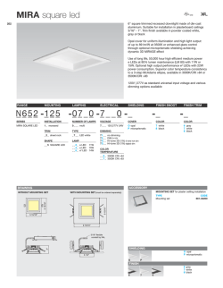
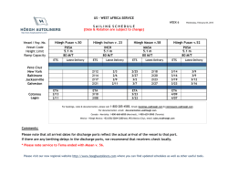
© Copyright 2026