
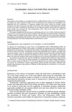
Correction of systematic model forcing bias of CLM using
Hydrol. Earth Syst. Sci., 19, 615–629, 2015
www.hydrol-earth-syst-sci.net/19/615/2015/
doi:10.5194/hess-19-615-2015
© Author(s) 2015. CC Attribution 3.0 License.
Correction of systematic model forcing bias of CLM using
assimilation of cosmic-ray Neutrons and land surface temperature:
a study in the Heihe Catchment, China
X. Han1,2,3 , H.-J. H. Franssen2,3 , R. Rosolem4 , R. Jin1,5 , X. Li1,5 , and H. Vereecken2,3
1 Key
Laboratory of Remote Sensing of Gansu Province, Cold and Arid Regions Environmental and Engineering Research
Institute, Chinese Academy of Sciences, Lanzhou 730000, PR China
2 Forschungszentrum Jülich, Agrosphere (IBG 3), Leo-Brandt-Strasse, 52425 Jülich, Germany
3 Centre for High-Performance Scientific Computing in Terrestrial Systems: HPSC TerrSys, Geoverbund ABC/J,
Leo-Brandt-Strasse, 52425 Jülich, Germany
4 Department of Civil Engineering, University of Bristol, Bristol BS8 1TR, UK
5 CAS Center for Excellence in Tibetan Plateau Earth Sciences, Chinese Academy of Sciences, Beijing 100101, PR China
Correspondence to: X. Han ([email protected])
Abstract. The recent development of the non-invasive
cosmic-ray soil moisture sensing technique fills the gap between point-scale soil moisture measurements and regionalscale soil moisture measurements by remote sensing. A
cosmic-ray probe measures soil moisture for a footprint with
a diameter of ∼ 600 m (at sea level) and with an effective
measurement depth between 12 and 76 cm, depending on
the soil humidity. In this study, it was tested whether neutron counts also allow correcting for a systematic error in
the model forcings. A lack of water management data often causes systematic input errors to land surface models.
Here, the assimilation procedure was tested for an irrigated
corn field (Heihe Watershed Allied Telemetry Experimental Research – HiWATER, 2012) where no irrigation data
were available as model input although for the area a significant amount of water was irrigated. In the study, the measured cosmic-ray neutron counts and Moderate-Resolution
Imaging Spectroradiometer (MODIS) land surface temperature (LST) products were jointly assimilated into the Community Land Model (CLM) with the local ensemble transform Kalman filter. Different data assimilation scenarios
were evaluated, with assimilation of LST and/or cosmic-ray
neutron counts, and possibly parameter estimation of leaf
area index (LAI). The results show that the direct assimilation of cosmic-ray neutron counts can improve the soil moisture and evapotranspiration (ET) estimation significantly,
correcting for lack of information on irrigation amounts. The
joint assimilation of neutron counts and LST could improve
further the ET estimation, but the information content of neutron counts exceeded the one of LST. Additional improvement was achieved by calibrating LAI, which after calibration was also closer to independent field measurements. It
was concluded that assimilation of neutron counts was useful for ET and soil moisture estimation even if the model has
a systematic bias like neglecting irrigation. However, also the
assimilation of LST helped to correct the systematic model
bias introduced by neglecting irrigation and LST could be
used to update soil moisture with state augmentation.
1
Introduction
Soil moisture plays a key role for crop and plant growth,
water resources management and land surface–atmosphere
interaction. Therefore accurate soil moisture retrieval is important. Point-scale measurements can be obtained by methods like time domain reflectometry (TDR) (Robinson et al.,
2003) and larger-scale, coarse soil moisture information from
remote sensing sensors (Entekhabi et al., 2010; Kerr et al.,
2010). Wireless sensor networks (WSNs) allow characterization of soil moisture at the catchment scale with many
local connected sensors at separated locations (Bogena et
al., 2010). TDR only measures the point-scale soil moisture,
and the maintenance of WSN is expensive. Recently, neutron count intensity measured by aboveground cosmic-ray
probes was proposed as an alternative information source
Published by Copernicus Publications on behalf of the European Geosciences Union.
616
X. Han et al.: Correction of systematic model forcing bias of CLM
on soil moisture. Neutron count intensity is measured noninvasively at an intermediate scale between the point-scale
and the coarse remote sensing scale (Zreda et al., 2008). A
network of cosmic-ray sensors (CRSs) has been set up over
North America (Zreda et al., 2012).
Cosmic rays are composed of primary protons mainly. The
fast neutrons generated by high-energy neutrons colliding
with nuclei lead to “evaporation” of fast neutrons, and the
generated and moderated neutrons in the ground can diffuse
back into the air, where their intensity can be measured by the
cosmic-ray soil moisture probe. Soil moisture affects the rate
of moderation of fast neutrons and controls the neutron concentration and the emission of neutrons into the air. Dry soils
have low moderating power and are highly emissive; wet
soils have high moderating power and are less emissive. The
neutrons are mainly moderated by the hydrogen atoms contained in the soil water and emitted to the atmosphere, where
the neutrons mix instantaneously at a scale of hundreds of
meters. The measurement area of a cosmic-ray soil moisture
probe represents a circle with a diameter of ∼ 600 m at sea
level (Desilets and Zreda, 2013), and the measurement depth
decreases nonlinearly from ∼ 76 (dry soils) to ∼ 12 cm (saturated soils) (Zreda et al., 2008). The measured cosmic-ray
neutron counts show an inverse correlation with soil moisture
content. The cosmic-ray neutron intensity could be reduced
to 60 % of surface cosmic-ray neutron intensity by increasing
the soil moisture from 0 to 40 % (Zreda et al., 2008). The soil
moisture estimation on the basis of cosmic-ray-probe-based
neutron counts over a horizontal footprint of hectometers has
received considerable attention in the scientific literature in
recent years (Desilets et al., 2010; Zreda et al., 2008, 2012).
Hydrogen atoms are present as water in the soil, lattice
soil water, belowground biomass, atmospheric water vapor,
snow water, aboveground biomass, intercepted water by vegetation and water on the ground. These additional hydrogen
sources contribute to the measured neutron intensity. The role
of these additional hydrogen sources should be included in
the analysis of the cosmic-ray measurements in order to isolate the main contribution from soil moisture. Formulations
for handling water vapor (Rosolem et al., 2013), for lattice
water and organic carbon (Franz et al., 2013) and for a litter
layer present on the soil surface (Bogena et al., 2013) have
been developed.
The positive impact of soil moisture data assimilation has
been shown in several studies. Importantly, surface soil moisture could be used to obtain better characterization of the root
zone soil moisture (Barrett and Renzullo, 2009; Crow et al.,
2008; Das et al., 2008; Draper et al., 2011; Li et al., 2010).
It has also shown that the assimilation of soil moisture observations can be used to correct rainfall errors (Crow et al.,
2011; Yang et al., 2009). Often a systematic bias between
measured and modeled soil moisture content can be found;
soil moisture estimation can be significantly improved using
joint state and bias estimation (De Lannoy et al., 2007; Kumar et al., 2012; Reichle, 2008). Also studies on data assimHydrol. Earth Syst. Sci., 19, 615–629, 2015
ilation of remotely sensed land surface temperature products
show a positive impact on the estimation of soil moisture,
latent heat flux and sensible heat flux (Ghent et al., 2010;
Xu et al., 2011). Also in these studies it was found that bias,
in these cases soil temperature bias, of land surface models
can be removed with land surface temperature assimilation
(Bosilovich et al., 2007; Reichle et al., 2010). Other studies have updated both land surface model states and parameters with soil moisture and land surface temperature data
(Bateni and Entekhabi, 2012; Han et al., 2014a; Montzka et
al., 2013; Pauwels et al., 2009). The assimilation of measured
cosmic-ray neutron counts in a land surface model was successfully tested, but these studies focused on state updating
alone (Rosolem et al., 2014; Shuttleworth et al., 2013). In this
paper we focus on the assimilation of measured cosmic-ray
neutron counts for improving soil moisture content characterization at the field scale. This paper focuses on the case
of model input being biased. Land surface models still are
affected by limited knowledge on water resources management, and for regions in China (and elsewhere) typically no
information on irrigation amounts is available as irrigation
is mainly by the flooding system. We analyze whether measured neutron counts are able to correct for such biases. This
case is not only relevant for neglecting irrigation in China,
but also for other water resources management issues (e.g.,
groundwater pumping) which are neglected in the simulations. Neglecting irrigation in land surface models results in
a large bias in the simulated soil moisture content because of
a lack of water input. The bias in soil moisture content also
results in a too-small latent heat flux and too-high sensible
heat flux. We hypothesize that data assimilation also can play
an important role for removing such biases in data-deficient
areas. One possible strategy in data assimilation studies for
handling this type of bias, which is not followed in this paper, is to calibrate the simulation model (e.g., land surface
model) prior to data assimilation to remove biases (Kumar et
al., 2012) and use the corrected simulation model in the context of sequential data assimilation. A different strategy was
followed in this paper, and no a priori bias correction was
carried out because this type of problem (neglecting water resources management) does not allow for such an a priori bias
correction. The bias can be attributed to the model structure,
model parameters, atmospheric forcing or observation data,
and the bias-aware assimilation requires the assumption that
the bias comes from a particular source. If the source of bias
is not attributed to the right source, model predictions cannot
be improved (Dee, 2005). Therefore bias-blind assimilation
was used for safety, and the bias estimation was not handled
explicitly. Instead, we investigated whether neutron counts
measured by cosmic-ray probe were able to correct for the
bias. The aim is to improve the soil moisture profile estimation in a crop land with seed corn as the main crop type.
In CLM, land surface fluxes are calculated based on the
Monin–Obukhov similarity theory. The sensible heat flux is
formulated as a function of temperature and leaf area index
www.hydrol-earth-syst-sci.net/19/615/2015/
X. Han et al.: Correction of systematic model forcing bias of CLM
(LAI), and the latent heat flux is formulated as a function of
the temperature and leaf stomatal resistances. The leaf stomatal resistance is calculated from the Ball–Berry conductance
model (Collatz et al., 1991). The updates of soil temperature
and vegetation temperature are derived based on the solar radiation absorbed by top soil (or vegetation), longwave radiation absorbed by soil (or vegetation), sensible heat flux from
soil (or vegetation) and latent heat flux from soil (or vegetation). Measured land surface temperature is composed of
the ground temperature and vegetation temperature. Therefore a difference between measured and calculated land surface temperature can be adjusted by changing land surface
fluxes. As land surface fluxes are sensitive to soil moisture
content, land surface temperature is sensitive to soil moisture
content.
Therefore, the land surface temperature (LST) products measured by the Moderate-Resolution Imaging Spectroradiometer (MODIS) Terra (MOD11A1) and Aqua
(MYD11A1) are also assimilated jointly to improve the soil
temperature profile estimation because the evapotranspiration (ET) is sensitive to the soil temperature. Two Terra LST
products can be obtained per day at 10:30/22:30 and two
Aqua LST products can be obtained per day at 01:30/13:30.
Soil moisture, land surface temperature and LAI influence
the estimation of latent and sensible heat fluxes (Ghilain et
al., 2012; Jarlan et al., 2008; Schwinger et al., 2010; van
den Hurk, 2003; Yang et al., 1999), and therefore this study
also focused on the calibration of LAI with the help of
the assimilation of land surface temperature. However, there
are large discrepancies between the remotely retrieved LAI
and measured values, and the MODIS LAI product underestimates in situ measured LAI by 44 % on average (http:
//landval.gsfc.nasa.gov/), and therefore the LAI is also calibrated by data assimilation. In summary, the novel aspects
of this work are the following: (1) investigating whether data
assimilation is able to correct for missing water resources
management data without a priori bias correction; (2) joint
assimilation of cosmic-ray neutron counts, LST and updating
of LAI; and (3) application of this framework to real-world
data in an irrigated area where detailed verification data were
available.
2
2.1
Materials and methods
617
Figure 1. Map of the cosmic-ray probe and SoilNet nodes in the
footprint of the CRS probe positioned at the Heihe River catchment.
the framework of the Heihe Watershed Allied Telemetry Experimental Research (HiWATER) (Li et al., 2013). SoilNet
wireless network nodes (Bogena et al., 2010) were deployed
to measure soil moisture content and soil temperature at four
layers (4, 10, 20 and 40 cm). One cosmic-ray soil moisture
probe (CRS-1000B) was installed (Han et al., 2014b) with 23
SoilNet nodes (Jin et al., 2013, 2014) in the footprint (Fig. 1).
The main crop type within the footprint of the cosmic-ray
probe is seed corn. The irrigation is applied through channels using the flooding irrigation method. Exact amounts of
applied irrigation are therefore not available.
The measured cosmic-ray neutron count data were processed to remove the outliers according to the sensor voltage (≤ 11.8 Volt) and relative humidity (≥ 80 %) (Zreda
et al., 2012). The surface fluxes were measured using the eddy covariance technique, and data were processed using EdiRe (http://www.geos.ed.ac.uk/abs/research/
micromet/EdiRe) software, in which the anemometer coordinate rotation, signal lag removal, frequency response correction, density corrections and signal de-spiking were done
for the raw data. The energy balance closure was not considered in this study. The LAI was measured by the LAI-2000
scanner during the field experiment; there are 17 samples collected on 14 days over 3 months.
Study area and measurement
2.2
The Heihe River basin is the second-largest inland river
basin of China; it is located at 97.1–102.0◦ E and 37.7–
42.7◦ N and covers an area of approximately 143 000 km2
(Li et al., 2013). In 2012, a multi-scale observation experiment of evapotranspiration with a well-equipped superstation
(Daman superstation) to measure the atmospheric forcings
and soil moisture at 2, 4, 10, 20, 40, 80, 120 and 160 cm depth
(Xu et al., 2013) was carried out from June to September in
www.hydrol-earth-syst-sci.net/19/615/2015/
Land surface model and data
The CLM was used to simulate the spatiotemporal distribution of soil moisture, soil temperature, land surface temperature, vegetation temperature, sensible heat flux, latent heat
flux and soil heat flux of the study area. The coupled water
and energy balance are modeled in CLM, and the land surface heterogeneity is represented by patched plant functional
types and soil texture (Oleson et al., 2013).
Hydrol. Earth Syst. Sci., 19, 615–629, 2015
618
X. Han et al.: Correction of systematic model forcing bias of CLM
The soil properties used in CLM were from the soil
database of China with 1 km spatial resolution (Shangguan
et al., 2013). The MODIS 500 m resolution plant functional
type product (MCD12Q1) (Sun et al., 2008), which was
resampled by nearest-neighbor interpolation to 1 km resolution, and the MODIS LAI product (MCD15A3) with
1 km spatial resolution (Han et al., 2012) were used as input. Due to a lack of measurement data, two atmospheric
forcing data sets were used: the Global Land Data Assimilation System reanalysis data (Rodell et al., 2004) was
interpolated using the National Centers for Environmental Prediction (NCEP) bilinear interpolation library iplib
in spatial and temporal dimensions and used in the CLM
for the spin-up period (http://www.nco.ncep.noaa.gov/pmb/
docs/libs/iplib/ncep_iplib.shtml). For the 3-month data assimilation period, hourly forcing data (incident longwave radiation, incident solar radiation, precipitation, air pressure,
specific humidity, air temperature and wind speed) from the
Daman superstation of HiWATER were available and used.
2.3
Cosmic-ray forward model
In this study, the newly developed COsmic-ray Soil Moisture Interaction Code (COSMIC) model (Shuttleworth et al.,
2013) was used as the cosmic-ray forward model to simulate the cosmic-ray neutron count rate using the soil moisture profile as input. The effective measurement depth of the
cosmic-ray soil moisture probe ranges from 12 cm (wet soils)
to 76 cm (dry soils) (Zreda et al., 2008), within which 86 % of
the aboveground measured neutrons originate. COSMIC also
calculates the effective sensor depth based on the cosmic-ray
neutron intensity and the soil moisture profile values (Franz
et al., 2012; Shuttleworth et al., 2013).
COSMIC makes several assumptions to calculate the number of fast neutrons reaching the cosmic-ray soil moisture
probe (NCOSMOS ) at a near-surface measurement location.
The soil layer with a depth of 3 m for the complete soil
profile was discretized into 300 layers for the integration of
Eq. (2) in COSMIC. The number of fast neutrons reaching
the cosmic-ray probe NCOSMOS is formulated as (Shuttleworth et al., 2013)
∞
(1)
{A(z)[αρs (z) + ρw (z)]
NCOSMOS = N
0
exp −
ms (z) mw (z)
+
L1
L2
A(z) =
2
π
dz,
π/2
exp
−1
ms (z) mw (z)
+
cos(θ ) L3
L4
dθ,
(2)
0
α = 0.405 − 0.102ρs ,
Hydrol. Earth Syst. Sci., 19, 615–629, 2015
(3)
L3 = −31.76 + 99.38ρs ,
(4)
where N is the high-energy neutron flux; z denotes the soil
layer depth (m); ρs the dry soil bulk density (g cm−3 ); ρw
the total water density, including the lattice water (g cm−3 );
and α denotes the ratio of fast-neutron creation factor.
L1 is the high-energy soil attenuation length with value
of 162.0 g cm−2 and L2 the high-energy water attenuation
length of 129.1 g cm−2 . In Eq. (2) θ is the angle between the
vertical below the detector and the line between the detector
and each point in the plane; ms (z) and mw (z) are the integrated mass per unit area of dry soil and water (g cm−2 ), respectively. L3 denotes the fast-neutron soil attenuation length
(g cm−2 ), and L4 stands for the fast-neutron water attenuation length with a value of 3.16 g cm−2 .
The cosmic-ray neutron intensity reaching the land surface
is influenced by air pressure, atmospheric water vapor content and incoming neutron flux. In order to isolate the contribution of soil moisture content to the measured neutron density, it is important to take these effects into account, and the
calibrated neutron count intensity can be derived as follows
NCorr = NObs fP fwv fi ,
(5)
where NCorr represents corrected neutron counts and NObs
the measured neutron counts. fP is the correction factor for
air pressure, fwv the correction factor for atmospheric water
vapor and fi the correction factor for incoming neutron flux.
The correction factor for air pressure fP can be calculated
as (Zreda et al., 2012)
fP = exp(
P − P0
),
L
(6)
where P (mbar) is the local air pressure, P0 (mbar) the average air pressure during the measurement period and L
(g cm−2 ) is the mass attenuation length for high-energy neutrons; the default value of 128 g cm−2 was used in this study
(Zreda et al., 2012).
The correction factor fwv for atmospheric water vapor is
calculated as (Rosolem et al., 2013)
ref
fwv = 1 + 0.0054(ρv0 − ρv0
),
(7)
where ρv0 (k gm−3 ) is the absolute humidity at the measureref (kg m−3 ) is the average absolute humidity
ment time and ρv0
during the measurement period.
Fluctuations in the incoming neutron flux should be removed because the cosmic-ray probe is designed to measure
the neutron flux based on the incoming background neutron
flux. The correcting factor fi for the incoming neutron flux
is calculated as
fi =
Nm
,
Navg
(8)
www.hydrol-earth-syst-sci.net/19/615/2015/
X. Han et al.: Correction of systematic model forcing bias of CLM
where Nm is the measured incoming neutron flux and Navg
is the average incoming neutron flux during the measurement period. The measured data at the Jungfraujoch station
in Switzerland at 3560 m (http://cosray.unibe.ch/) were used
to calculate Nm and Navg . The temporal (secular or diurnal)
variations caused by the sunspot cycle could be removed after this correction (Zreda et al., 2012).
In this study, the soil moisture for the CRS footprint scale
was calculated from the arithmetic mean of the 23 SoilNet soil moisture observations. The calibration of the highenergy neutron intensity parameter N in Eq. (1) was done
using the measured cosmic-ray neutron counts rate and averaged soil moisture content at the CRS footprint scale. Because lattice water was unknown for this site, a value of
3 % was assumed in this study (Franz et al., 2012). Hourly
soil moisture measurements for a period of 2.5 months were
used for COSMIC calibration. Inside the cosmic-ray probe
footprint, the amount of applied irrigation was spatially variable due to the different management practice of each farmer.
The gradient search algorithm L-BFGS-B (Zhu et al., 1997)
was used to minimize the root mean square error (RMSE) of
the differences between simulated cosmic-ray neutron counts
(using measured soil moisture by SoilNet as input to COSMIC) and the measured neutron counts NCorr . The optimized
parameter value of N was 615.96 counts h−1 in this case.
The simulated soil moisture content for 10 CLM soil layers (3.8 m depth) was used as input to COSMIC in order to
simulate the corresponding neutron count intensity and compare it with the measured neutron count intensity. It should
be mentioned that it is unlikely that anything beyond 1 m
depth will substantially impact the results because the effective measurement depth of the cosmic-ray probe is between
12 and 76 cm. The COSMIC model assumes a more detailed
soil profile. COSMIC interpolates the soil moisture information from the 10 CLM soil layers to information for 300 soil
layers of 1 cm depth. The contribution of each soil layer to
the measured neutron flux will change temporally depending on the soil moisture condition. Therefore the effective
measurement depth of the cosmic ray probe will also change
temporally. COSMIC calculates the vertically weighted soil
moisture content based on the vertical distribution of soil
moisture content.
2.4
Two-source formulation – TSF
The land surface temperature products of MODIS are composed of a ground temperature and vegetation temperature
component, which are however unknown. CLM models the
ground temperature and vegetation temperature separately,
but it does not model the composed land surface temperature
as seen by MODIS. The corresponding land surface temperature of CLM should therefore be modeled for data assimilation purposes. The two-source formulation (Kustas and Anderson, 2009) was used in this study to calculate the land surface temperature from the MODIS view angle using ground
www.hydrol-earth-syst-sci.net/19/615/2015/
619
temperature and vegetation temperature simulated by CLM:
Ts = [Fc ( )Tc4 + (1 − Fc ( )Tg4 )]1/4 ,
(9)
where TS (K) is the composed surface temperature as seen
by the MODIS sensor, Fc ( ) is the fraction vegetation cover
observed from the sensor view angle (radians), Tc (K) is
the vegetation temperature and Tg (K) is the ground temperature (Kustas and Anderson, 2009):
Fc ( ) = 1 − exp
−0.5 ( )LAI
,
cos
(10)
where ( ) is a clumping index to represent the nonrandom leaf area distributions of farmland or other heterogeneous land surfaces (Anderson et al., 2005); it is defined as
( )=
max
0.49 max
,
0.49 + ( max − 0.49) exp(kθ 3.34 )
= 0.49 + 0.51(sin )0.05 ,
k = −{0.3 + [0.833(sin )0.1 ]14 }.
2.5
(11)
(12)
(13)
Assimilation approach
The local ensemble transform Kalman filter (LETKF) was
used as the assimilation algorithm, which is one of the
square-root variants of the ensemble Kalman filter (Evensen,
2003; Hunt et al., 2007; Miyoshi and Yamane, 2007). The
model uncertainties are represented using the ensemble simulation of model states, and LETKF derives the background
error covariance using the model state ensemble members.
LETKF uses the non-perturbed observations to update all the
ensemble members of model states at each assimilation step.
In this study, x b1 , . . ., x bN denote the model state ensemble
members; x b is the ensemble mean of x b1 , .., x bN ; N is the ensemble size; y b1 , . . ., y bN denote the mapped model state ensemble members; y b is the ensemble mean of y b1 , . . ., y bN ; and
H is the observation operator (COSMIC for soil moisture or
the two-source function for land surface temperature). The
analysis step of LETKF can be summarized as follows.
Prepare the model state vector Xb :
X b = [x b1 − x b , . . ., x bN − x b ]
(14)
where x b is composed of one vertically weighted soil moisture content and soil moisture content for 10 CLM layers,
resulting in a state dimension equal to 11 if only the neutron count observation was assimilated; and x b is composed
of surface temperature, ground temperature, vegetation temperature and soil temperature for 15 CLM layers if only the
land surface temperature observations were assimilated without soil moisture update, giving a state dimension of 18. The
Hydrol. Earth Syst. Sci., 19, 615–629, 2015
620
X. Han et al.: Correction of systematic model forcing bias of CLM
water and energy balance are coupled, and in CLM the energy balance is firstly solved; then the derived surface fluxes
are used for updating soil moisture content. The cross correlation between the soil temperature and soil moisture can
be calculated using the ensemble prediction in LETKF, and
this makes the updating of soil moisture by assimilating land
surface temperature possible. We also used the land surface
temperature to update the soil moisture profile; in this case
the soil moisture vector was augmented to the LETKF state
vector of land surface temperature assimilation, resulting in
a state dimension of 28.
Construct the mapped model state vector Y b after transformation of observation operator:
y bi = H (x bi ),
(15)
Y b = y b1 − y b , . . ., y bN − y b .
(16)
The following analysis is looped for each model grid cell
to calculate the update of model state ensemble members.
Calculate analysis error covariance matrix Pa :
Pa = [(N − 1) I + Y bT R−1 Y b ],
matter density) and vegetation parameters (LAI, etc.). In a
preliminary sensitivity study it was found that for this site
simulation results were more sensitive to the LAI than to
soil properties. Soil texture is also quite well known for this
site from measurements. Therefore in this study, only the
LAI was in some of the simulation scenarios calibrated. In
the different scenarios of land surface temperature assimilation, the LETKF state vector was also augmented to include
LAI as a calibration target. As a consequence, the augmented
state vector contains surface temperature, ground temperature, vegetation temperature, 15 layers of soil temperature
and LAI, making up a state dimension equal to 19 for the
scenarios of land surface temperature assimilation without
soil moisture update; for the scenarios of land surface temperature with soil moisture update, the state dimension is 29.
The 10 layers of soil moisture and 15 layers of soil temperature are the standard CLM layout for both soil moisture and
soil temperature. The hydrology calculations are done over
the top 10 layers, and the bottom 5 layers are specified as
bedrock. The lower 5 layers are hydrologically inactive layers. Temperature calculations are done over all layers (Oleson et al., 2013).
(17)
3
where I is the identity matrix.
The perturbations in ensemble space are calculated as
Wa = [(N − 1)Pa ]1/2 .
(18)
Calculate the analysis mean wa in ensemble space and add
to each column of W a to get the analysis ensemble in ensemble space:
w a = Pa Y bT R−1 (y o − y b ).
(19)
Calculate the new analysis:
Xa = X b [wa + Wa ] + x b ,
(20)
where R is the observation error covariance matrix, y o is the
observation vector and X a contains the updated model ensemble members.
The LETKF method can also be extended to do parameter
estimation using a state augmentation approach (Bateni and
Entekhabi, 2012; Li and Ren, 2011; Moradkhani et al., 2005;
Nie et al., 2011). Alternative strategies for parameter estimation are a dual approach (Moradkhani et al., 2005) with separate updating of states and parameters. Vrugt et al. (2005)
also proposed a dual approach with parameter updating in an
outer optimization loop using a Markov chain Monte Carlo
method, and state updating in an inner loop. The a priori calibration of model parameters is also an option (Kumar et al.,
2012). With the augmentation approach, the state vector of
LETKF can be augmented by the parameter vector including soil properties (sand fraction, clay fraction and organic
Hydrol. Earth Syst. Sci., 19, 615–629, 2015
Experiment setup
First the 50 ensemble members of CLM with perturbed soil
properties and atmospheric forcing data were driven from 1
January to 31 May 2012 to do the CLM spin-up; second an
additional assimilation period of cosmic-ray neutron counts
was done from 1 June to 30 August 2012 to reduce the spinup error. The final CLM states on 30 August 2012 were used
as the initial states for 1 June 2012 for the data assimilation
scenarios. Perturbed soil properties were generated by adding
a spatially uniform perturbation sampled from a uniform distribution between −10 and 10 % to the values extracted from
the Soil Database of China for Land Surface Modeling (1 km
spatial resolution). The LAI was perturbed with multiplicative uniform distributed random noise in the range of [0.8–
1.2]. The perturbations added to the model forcings show
correlations in space and time. The spatial correlation was
induced by a fast Fourier transform, and the temporal correlation by a first-order auto-regressive model (Han et al., 2013;
Kumar et al., 2009; Reichle et al., 2010). The statistics on the
perturbation of the forcing data are summarized in Table 1.
The values of standard deviations and temporal correlations
in Table 1 were chosen based on previous catchment-scale
and regional-scale data assimilation studies (De Lannoy et
al., 2012; Kumar et al., 2012; Reichle et al., 2010).
The cosmic-ray neutron intensity was assimilated every
3 days at 12:00 Z from 1 June 2012 onwards. We found that
the differences between daily assimilation and 3-day assimilation were small; therefore only the results of the 3-day
assimilation are shown. The measured neutron count intensity showed large temporal fluctuations in time, and these
www.hydrol-earth-syst-sci.net/19/615/2015/
X. Han et al.: Correction of systematic model forcing bias of CLM
621
Table 1. Summary of perturbation parameters for atmospheric forcing data.
Variables
Noise
Standard
deviation
Precipitation
Shortwave radiation
Longwave radiation
Air temperature
Multiplicative
Multiplicative
Additive
Additive
0.5
0.3
20 W m−2
1K
Time
correlation
scale
Spatial
correlation
Scale
Cross
correlation
24 h
24 h
24 h
24 h
5 km
5 km
5 km
5 km
[ 1.0,-0.8, 0.5, 0.0,
-0.8, 1.0,-0.5, 0.4,
0.5, -0.5, 1.0, 0.4,
0.0, 0.4, 0.4, 1.0]
Figure 2. Measured and temporally smoothed CRS neutron counts.
fluctuations did not correspond to the temporal variations
of soil moisture. Therefore the measured neutron count intensity was smoothed with the Savitzky–Golay filter using a
moving average window of size 31 h and a polynomial of order 4 (Savitzky and Golay, 1964). The originally measured
neutron counts and smoothed neutron counts are plotted in
Fig. 2. The assimilation frequency of MODIS LST products of MOD11A1 and MYD11A1 was up to 4 times (maximum) per day depending on the data availability. There are
230 observation data (including cosmic-ray probe neutron
counts, MODIS LST, MOD11A1 and MYD11A1 LST) in
the whole assimilation window. The variance of the instantaneous measured neutron intensity is equal to the measured
neutron count intensity (Zreda et al., 2012) and smaller for
temporal averaging for daily or sub-daily applications. The
instantaneous neutron intensity was assimilated in this study.
The variance of MODIS LST was assumed to be 1 K (Wan
and Li, 2008).
The 4-day MODIS LAI product was aggregated and used
as the CLM LAI parameter. Because the LAI from MODIS
is usually lower than the true value (compared with the fieldmeasured LAI in the HiWATER experiment) and because the
surface flux and surface temperature are sensitive to the LAI,
two additional scenarios were investigated where LAI was
calibrated to study the impact of LAI estimation on surface
flux estimation within the data assimilation framework.
The following assimilation scenarios were compared:
1. CLM: open-loop simulation without assimilation.
www.hydrol-earth-syst-sci.net/19/615/2015/
2. Only_CRS: only the measured neutron counts were assimilated.
3. Only_LST: only the MODIS LST products were assimilated. The quality control flags of LST products were
used to select the data with good quality for assimilation.
4. CRS_LST: the measured neutron counts and MODIS
LST products were assimilated jointly. In the above scenarios, the neutron count data were used to update the
soil moisture and the LST data were used to update
the ground temperature, vegetation temperature and soil
temperature.
5. LST_Feedback: we also evaluated the scenario of assimilating the LST measurements to update the soil
moisture profile.
6. CRS_LST_Par_LAI: the LAI was included as variable
to be calibrated; otherwise the scenario was the same as
CRS_LST.
7. LST_Feedback_Par_LAI: the LAI was included as variable to be calibrated; otherwise the scenario was the
same as LST_Feedback.
8. CRS_LST_True_LAI: the in situ measured LAI during
the HiWATER experiment was used in the model simulation.
Hydrol. Earth Syst. Sci., 19, 615–629, 2015
622
X. Han et al.: Correction of systematic model forcing bias of CLM
Figure 3. Soil moisture at 10 cm (upper) and 20 cm (lower) depth as obtained from an open-loop run (CLM), local sensors (Obs) and different
simulation scenarios. For a description of the scenarios see Sect. 3 of the paper. The CRS neutron counts were assimilated on 1 June.
4
Results and discussion
In order to evaluate the assimilation results for the different
scenarios outlined in Sect. 3, the RMSE was used:
N
RMSE =
(estimated − measured)2
n=i
N
,
(21)
where “estimated” is the ensemble mean without assimilation or the ensemble mean after assimilation, and “measured”
is measured soil moisture content evaluated at the SoilNet
nodes (or latent heat flux, sensible heat flux or soil heat flux).
N is the number of time steps. For the soil moisture analysis in this study, N is equal to 2184. The smaller the RMSE
value is, the closer assimilation results are to measured values, which is in general considered to be desirable.
The temporal evolution of soil moisture content at 10,
20, 50 and 80 cm depth for different scenarios is plotted
in Figs. 3 and 4. The RMSE values for different scenarios are summarized in Table 2. Assimilating the land surface temperature could improve the soil moisture profile
estimation in the scenario of LST_Feedback_Par_LAI; the
soil moisture results are better than the open-loop run at
all depths. With the assimilation of CRS neutron counts,
the soil moisture RMSE values at 10 and 20 cm depth
(scenarios CRS_LST_Par_LAI and CRS_LST_True_LAI)
Hydrol. Earth Syst. Sci., 19, 615–629, 2015
Table 2. Root mean square error (RMSE) of soil moisture profile of open-loop run (CLM), feedback assimilation of land surface
temperature including LAI calibration (LST_Feedback_Par_LAI),
bivariate assimilation of neutron counts and land surface temperature including LAI calibration (CRS_LST_Par_LAI) and bivariate assimilation of neutron counts and land surface temperature
(CRS_LST_True_LAI).
RMSE (m3 m−3 )
Soil layer
depth
10 cm
20 cm
50 cm
80 cm
Open loop
(CLM)
LST_Feedback
_Par_LAI
CRS_LST
_Par_LAI
CRS_LST
_True_LAI
0.202
0.167
0.193
0.188
0.137
0.106
0.112
0.124
0.085
0.047
0.112
0.136
0.086
0.048
0.119
0.146
decreased significantly. The RMSE values for the scenarios Only_CRS and CRS_LST (not shown) are similar to
CRS_LST_Par_LAI, which indicates that the main improvement for the soil moisture profile characterization is achieved
by neutron count assimilation; and land surface temperature assimilation and LAI estimation play a minor role.
Without assimilation of cosmic-ray probe neutron counts,
the soil moisture simulation cannot be improved (scenario
Only_LST). However, the scenarios of LST_Feedback and
LST_Feedback_Par_LAI improve the soil moisture profile
www.hydrol-earth-syst-sci.net/19/615/2015/
X. Han et al.: Correction of systematic model forcing bias of CLM
623
Figure 4. Same as Fig. 3 but for 50 cm (upper) and 80 cm (lower).
characterization, which shows that explicitly using LST to
update soil moisture content in the data assimilation routine gives better results than using LST only to update soil
moisture by the model equations. Results of LST_Feedback
and LST_Feedback_Par_LAI are similar; therefore only results for LST_Feedback_Par_LAI are shown in Figs. 3 and 4.
This implies that the improved soil moisture characterization
due to LAI calibration is low. The results for the cosmic-ray
probe neutron count assimilation proved that the cosmic-ray
probe sensor can be used to improve the soil moisture profile
estimation at the footprint scale.
Figure 5 depicts the scatterplots of measured ET versus
modeled ET for different scenarios, and the accumulated
ET for all scenarios are summarized in the lower-right corner of Fig. 5. The EC-measured ET is 384.7 mm for the
assimilation period, without energy balance closure correction. The true evapotranspiration is therefore likely larger,
but not much larger as the energy balance gap was limited
(3.7 %). The CLM-estimated ET, without data assimilation,
using only precipitation as input is 223.7 mm and is much
smaller than the measured value as applied irrigation is not
considered in the model. This open-loop simulated value
would imply water stress and a limitation of canopy transpiration and soil evaporation due to low soil moisture content.
Assimilation of land surface temperature only (Only_LST)
hardly affected the estimated ET and was not able to correct
www.hydrol-earth-syst-sci.net/19/615/2015/
for the artificial water stress condition. However, if land surface temperature was used to update soil moisture directly,
taking into account correlations between the two states in
the data assimilation routine, the ET estimates improved to
336.8 and 354.8 mm for the scenarios of LST_Feedback and
LST_Feedback_Par_LAI, respectively. The assimilation of
land surface temperature of MODIS with soil moisture update results in significant improvements of ET.
The different neutron count assimilation scenarios also resulted in significantly improved estimates of ET. Univariate assimilation of cosmic-ray neutron data (Only_CRS) resulted in 301.9 mm ET. This shows that the impact of neutron
count assimilation to correct evapotranspiration estimates is
slightly smaller than the impact of land surface temperature
with soil moisture update. Joint assimilation of land surface
temperature data and cosmic-ray neutron data (CRS_LST)
gave a slightly larger ET of 310.6 mm than Only_CRS. The
scenarios of CRS_LST_Par_LAI and CRS_LST_True_LAI
gave the best ET estimates (360.5 and 349.3 mm). This shows
that correcting the biased LAI estimates from MODIS by in
situ data or calibration helped to improve model estimates.
The RMSE values of latent heat flux, sensible heat
flux and soil heat flux for all scenarios are summarized
in Fig. 6. It is obvious that the RMSE values are very
large for both the latent heat flux (123.9 W m−2 ) and sensible heat flux (80.5 W m−2 ) for the open-loop run and
Hydrol. Earth Syst. Sci., 19, 615–629, 2015
624
X. Han et al.: Correction of systematic model forcing bias of CLM
Figure 5. Evapotranspiration estimated according to different scenarios for the period June–August 2012. For a full description see Fig. 3.
all other scenarios where the soil moisture was not updated. When the land surface temperature was assimilated to update the soil moisture, the latent heat flux
RMSE decreased to 60.5 (LST_Feedback) and 62.5 W m−2
(LST_Feedback_Par_LAI). The scenario where soil moisture and LAI are jointly updated (LST_Feedback_Par_LAI)
gave worse results than the scenario of LST_Feedback.
Again, the assimilation of neutron counts also resulted in a
strong RMSE reduction for the latent heat flux (76.5 W m−2
for Only_CRS). When in addition land surface temperature
was assimilated and LAI optimized, the RMSE value of latent heat flux further decreased to 56.1 W m−2 (70.7 W m−2
without LAI optimization). When the field-measured LAI
was used instead in the assimilation (CRS_LST_True_LAI),
the RMSE was 61.0 W m−2 . These results are in correspondence with the ones discussed before for soil moisture characterization. Evidently, the combined assimilation of cosmicray probe neutron counts and land surface temperature, and
calibration of LAI (or use of field-measured LAI as model
input) shows the strongest improvement for the estimation of
land surface fluxes. The soil heat flux did not show a clear
improvement related to assimilation and showed only some
Hydrol. Earth Syst. Sci., 19, 615–629, 2015
improvement when LAI was calibrated. For the scenario of
land surface temperature assimilation without soil moisture
update (Only_LST), estimates of latent and sensible heat flux
are not improved. It means that, under water stress conditions, the improved characterization of land surface temperature (and soil temperature) does not contribute to a better
estimation of land surface fluxes.
The
updated
LAI
for
the
scenarios
of
LST_Feedback_Par_LAI and CRS_LST_Par_LAI is
shown in Fig. 7. The MODIS LAI product was used as input
for CLM, and time series are plotted as blue line in Fig. 7
(Background). The LAI was also measured in the HiWATER
experiment, and the measured values are shown as a green
star (Observation). Ens_Mean represents the mean LAI of all
ensemble members (Ensembles). It is obvious that MODIS
underestimates the LAI compared with the observations.
With the assimilation of land surface temperature, the LAI
could be updated and be closer to the observations, but
there is still a significant discrepancy between the measured
LAI and the updated one. The LAI values for the scenario
with LAI calibration (CRS_LST_Par_LAI) are close to
the measured LAI values (CRS_LST_True_LAI), which
www.hydrol-earth-syst-sci.net/19/615/2015/
X. Han et al.: Correction of systematic model forcing bias of CLM
625
Figure 7. LAI evolution for the period June–August 2012. Displayed are the measured LAI (Observation), default values (Background), mean of ensemble members (Ens_Mean) and ensemble
members (Ensembles) for the scenarios of LST_Feedback_Par_LAI
(upper) and CRS_LST_Par_LAI (lower).
Figure 6. RMSE values of latent heat flux, sensible heat flux and
soil heat flux for the period June–August 2012. For a description of
the scenarios see Sect. 3 of the paper.
is an encouraging result. The calibrated LAI shows some
unrealistic increases and decreases during the assimilation
period, which is inherent to the data assimilation approach.
A smoothed representation of the LAI might provide a more
realistic picture.
This study illustrates that, for an irrigated farmland, the
measured cosmic-ray probe neutron counts can be used to
improve the soil moisture profile estimation significantly.
Without irrigation data, CLM underestimated soil moisture
content. The cosmic-ray neutron count data assimilation can
www.hydrol-earth-syst-sci.net/19/615/2015/
be used as an alternative way to retrieve the soil moisture
content profile in CLM. The improved soil moisture simulation was helpful for the characterization of the land surface
fluxes. The univariate assimilation of land surface temperature without soil moisture update is not helpful for the estimation of land surface fluxes and even worsened the sensible heat flux characterization (Fig. 6). However, in a multivariate data assimilation framework where land surface temperature was assimilated together with measured cosmic-ray
probe neutron counts, the land surface temperature assimilation contributed significantly to an improved ET estimation.
The simulated canopy transpiration in CLM was in general
too low, even when the water stress condition was corrected
by assimilating neutron counts, which was related to small
values of the LAI. The additional estimation of LAI through
the land surface temperature assimilation resulted in an increase of the LAI, yielding an increase of estimated ET.
In general, land surface models need to be calibrated before use in land data assimilation, especially if there is an
apparent large bias in the model simulation (Dee, 2005). The
simulation of soil moisture and surface fluxes was biased in
our study, mainly due to the lack of irrigation water as input. This bias cannot be corrected a priori without exact irrigation data, which are not available in the field. The data
assimilation was proven to be an efficient way to remove
the model bias in this case. We also calculated the equivalent water depth to analyze the equivalent irrigated water
after each step of soil moisture update. For the scenarios of
CRS_LST_Par_LAI and CRS_LST_True_LAI, the equivaHydrol. Earth Syst. Sci., 19, 615–629, 2015
626
X. Han et al.: Correction of systematic model forcing bias of CLM
lent irrigation in 3 months was 693.6 and 607.6 mm, respectively. Because the irrigation method is flood irrigation, it is
not easy to evaluate the true irrigation applied in the field.
From the results we see, however, that the applied irrigation (in the model) is much larger than actual ET (∼ 600 to
700 mm vs. ∼ 400 mm). This could indicate that the amount
of applied irrigation in the model is too large, but irrigation
by flooding is also inefficient and results in excess runoff
and infiltration to the groundwater, because it cannot be controlled as well as sprinkler irrigation or drip irrigation. Therefore, the calculated amount of irrigation could be realistic but
might also be too large if soil properties are erroneous in the
model.
The soil moisture content measured by the cosmic-ray
probe represents the depth between 12 cm (very humid) and
76 cm (extremely dry case) depending on the amount of soil
water (soil moisture content and lattice water). Therefore the
effective sensor depth of the cosmic-ray probe will change
over time. In order to model the variable sensor depth and
the relationship between the soil moisture content and neutron counts, the new developed COSMIC model was used
as the observation operator in this study. Additionally the
influences of air pressure, atmospheric vapor pressure and
incoming neutron counts were removed from the originally
measured neutron counts. Because there is still some water in
the crop which also affects the cosmic-ray probe sensor, the
COSMIC observation operator could be improved to include
vegetation effects. Several default parameters proposed by
Shuttleworth et al. (2013) were used in the COSMIC model,
and these parameters probably need further calibration following the development of the COSMIC model.
The spatial distribution of soil moisture for the study area
was very heterogeneous due to the small farmland patches
and different irrigation periods for the different farmlands.
Therefore the soil moisture content inferred by SoilNet may
not represent the true soil moisture content of the cosmicray probe footprint, which is a further limitation of this
study. Although the Cosmic-ray Soil Moisture Observing
System (COSMOS) has been designed as a continentalscale network by installing 500 COSMOS probes across the
USA (Zreda et al., 2012), there are still some disadvantages of COSMOS compared with remote sensing. COSMOS is also expensive for extensive deployment to measure
continental/regional-scale soil moisture.
5
Summary and conclusions
In this paper, we studied the univariate assimilation of
MODIS land surface temperature products, the univariate
assimilation of measured neutron counts by the cosmic-ray
probe, the bivariate assimilation of land surface temperature
and neutron count data, and the additional calibration of LAI
for an irrigated farmland at the Heihe Catchment in China,
where data on the amount of applied irrigation were lackHydrol. Earth Syst. Sci., 19, 615–629, 2015
ing. The most important objective of this study was to test
whether data assimilation is able to correct for the absence
of information on water resources management as model input, a situation commonly encountered in large-scale land
surface modeling. For the specific case of lacking irrigation
data, no prior bias correction is possible. The bias-blind assimilation without explicit bias estimation was used. We focused on the model bias introduced by the forcing data and
the LAI, and neglected the other sources of bias. When LAI
was calibrated, this was done at each data assimilation step of
land surface temperature. The data assimilation experiments
were carried out with the CLM, and the data assimilation algorithm used was the LETKF. A likely further model bias,
besides missing information on irrigation, is the underestimation of LAI by MODIS, which was used to force the model.
The results show that the direct assimilation of measured comic-ray neutron counts improves the estimation of
soil moisture significantly, whereas univariate assimilation of
land surface temperature without soil moisture update does
not improve soil moisture estimation. However, if the land
surface temperature was assimilated to update the soil moisture profile directly with the help of the state augmentation
method, the evapotranspiration and soil moisture could be
improved significantly. This result suggests that the land surface temperature remote sensing products are needed to correct the characterization of the soil moisture profile and the
evapotranspiration. The improved soil moisture estimation
after the assimilation of neutron counts resulted in a better ET
estimation during the irrigation season, correcting the toolow ET of the open-loop simulation. The joint assimilation
of neutron counts and MODIS land surface temperature improved the ET estimation further compared to neutron count
assimilation only. The best ET estimation was obtained for
the joint assimilation of cosmic-ray neutron counts, MODIS
land surface temperature including calibration of the LAI (or
if field-measured LAI was used as input). This shows that
bias due to neglected information on water resources management can be corrected by data assimilation if a combination of soil moisture and land surface temperature data is
available.
We can conclude that data assimilation of neutron counts
and land surface temperature is useful for ET and soil moisture estimation of an irrigated farmland, even if irrigation
data are not available and excluded from model input. The
land surface temperature measurements are an alternative
data source to improve the soil moisture and land surface flux
estimation under water stress conditions. This shows the potential of data assimilation to correct also a systematic model
bias. LAI optimization further improves simulation results,
which is also likely related to a systematic underestimation
of LAI by the MODIS remote sensing product. The results
of using the calibrated LAI are comparable to the results of
using field-measured LAI as model input.
www.hydrol-earth-syst-sci.net/19/615/2015/
X. Han et al.: Correction of systematic model forcing bias of CLM
Acknowledgements. This work is supported by the NSFC (National Science Foundation of China) project (grant nos. 41271357,
91125001), the Knowledge Innovation Program of the Chinese
Academy of Sciences (grant no. KZCX2-EW-312) and the Transregional Collaborative Research Centre 32, financed by the German
Science Foundation. Jungfraujoch neutron monitor data were
kindly provided by the Cosmic-ray Group, Physikalisches Institut,
University of Bern, Switzerland. We acknowledge computing
resources and time on the Supercomputing Center of Cold and
Arid Region Environment and Engineering Research Institute of
Chinese Academy of Sciences.
Edited by: H. Cloke
References
Anderson, M. C., Norman, J. M., Kustas, W. P., Li, F., Prueger,
J. H., and Mecikalski, J. R.: Effects of Vegetation Clumping on
Two–Source Model Estimates of Surface Energy Fluxes from an
Agricultural Landscape during SMACEX, J. Hydrometeorol., 6,
892–909, 2005.
Barrett, D. J. and Renzullo, L. J.: On the Efficacy of Combining
Thermal and Microwave Satellite Data as Observational Constraints for Root-Zone Soil Moisture Estimation C-7972-2009,
J. Hydrometeorol., 10, 1109–1127, 2009.
Bateni, S. M. and Entekhabi, D.: Surface heat flux estimation with the ensemble Kalman smoother: Joint estimation
of state and parameters, Water Resour. Res., 48, W08521,
doi:10.1029/2011wr011542, 2012.
Bogena, H. R., Herbst, M., Huisman, J. A., Rosenbaum, U.,
Weuthen, A., and Vereecken, H.: Potential of Wireless Sensor
Networks for Measuring Soil Water Content Variability, Vadose
Zone J., 9, 1002–1013, 2010.
Bogena, H. R., Huisman, J. A., Baatz, R., Hendricks Franssen, H.
J., and Vereecken, H.: Accuracy of the cosmic-ray soil water content probe in humid forest ecosystems: The worst case scenario,
Water Resour. Res.., 49, 5778–5791, 2013.
Bosilovich, M. G., Radakovich, J. D., da Silva, A., Todling, R., and
Verter, F.: Skin temperature analysis and bias correction in a coupled land-atmosphere data assimilation system, J. Meteorol. Soc.
Jpn., 85, 205–228, 2007.
Collatz, G. J., Ball, J. T., Grivet, C., and Berry, J. A.: Physiological
and Environmental-Regulation of Stomatal Conductance, Photosynthesis and Transpiration – a Model That Includes a Laminar
Boundary-Layer, Agr. Forest Meteorol., 54, 107–136, 1991.
Crow, W. T., Kustas, W. P., and Prueger, J. H.: Monitoring rootzone soil moisture through the assimilation of a thermal remote
sensing-based soil moisture proxy into a water balance model,
Remote Sens. Environ., 112, 1268–1281, 2008.
Crow, W. T., van den Berg, M. J., Huffman, G. J., and Pellarin,
T.: Correcting rainfall using satellite-based surface soil moisture
retrievals: The Soil Moisture Analysis Rainfall Tool (SMART),
Water Resour. Res., 47, W08521, doi:10.1029/2011wr010576,
2011.
Das, N. N., Mohanty, B. P., Cosh, M. H., and Jackson, T. J.: Modeling and assimilation of root zone soil moisture using remote sensing observations in Walnut Gulch Watershed during SMEX04,
Remote Sens. Environ., 112, 415–429, 2008.
www.hydrol-earth-syst-sci.net/19/615/2015/
627
De Lannoy, G. J. M., Houser, P. R., Pauwels, V. R. N., and
Verhoest, N. E. C.: State and bias estimation for soil moisture profiles by an ensemble Kalman filter: Effect of assimilation depth and frequency, Water Resour. Res., 43, W06401,
doi:10.1029/2006WR005100, 2007.
De Lannoy, G. J. M., Reichle, R. H., Arsenault, K. R., Houser,
P. R., Kumar, S., Verhoest, N. E. C., and Pauwels, V. R.
N.: Multiscale assimilation of Advanced Microwave Scanning
Radiometer-EOS snow water equivalent and Moderate Resolution Imaging Spectroradiometer snow cover fraction observations in northern Colorado, Water Resour. Res., 48, W01522,
doi:10.1029/2011WR010588, 2012.
Dee, D. P.: Bias and data assimilation, Q. J. Roy. Meteorol. Soc.,
131, 3323–3343, 2005.
Desilets, D. and Zreda, M.: Footprint diameter for a cosmic-ray soil
moisture probe: Theory and Monte Carlo simulations, Water Resour. Res., 49, 3566–3575, 2013.
Desilets, D., Zreda, M., and Ferré, T. P. A.: Nature’s neutron probe:
Land surface hydrology at an elusive scale with cosmic rays,
Water Resour. Res., 46, W11505, doi:10.1029/2009WR008726,
2010.
Draper, C. S., Mahfouf, J. F., and Walker, J. P.: Root zone soil moisture from the assimilation of screen-level variables and remotely
sensed soil moisture, J. Geophys. Res.-Atmos., 116, D02127,
doi:10.1029/2010JD013829, 2011.
Entekhabi, D., Njoku, E. G., O’Neill, P. E., Kellogg, K. H., Crow,
W. T., Edelstein, W. N., Entin, J. K., Goodman, S. D., Jackson,
T. J., Johnson, J., Kimball, J., Piepmeier, J. R., Koster, R. D.,
Martin, N., McDonald, K. C., Moghaddam, M., Moran, S., Reichle, R., Shi, J. C., Spencer, M. W., Thurman, S. W., Tsang, L.,
and Van Zyl, J.: The Soil Moisture Active Passive (SMAP) Mission, Proc. IEEE, 98, 704–716, doi:10.1109/jproc.2010.2043918,
2010.
Evensen, G.: The ensemble Kalman filter: Theoretical formulation and practical implementation, Ocean Dynam., 53, 343–367,
2003.
Franz, T. E., Zreda, M., Ferre, T. P. A., Rosolem, R., Zweck, C.,
Stillman, S., Zeng, X., and Shuttleworth, W. J.: Measurement
depth of the cosmic ray soil moisture probe affected by hydrogen from various sources, Water Resour. Res., 48, W08515,
doi:10.1029/2012WR011871, 2012.
Franz, T. E., Zreda, M., Rosolem, R., and Ferre, T. P. A.: A universal calibration function for determination of soil moisture
with cosmic-ray neutrons, Hydrol. Earth Syst. Sci., 17, 453–460,
doi:10.5194/hess-17-453-2013, 2013.
Ghent, D., Kaduk, J., Remedios, J., Ardo, J., and Balzter, H.:
Assimilation of land surface temperature into the land surface
model JULES with an ensemble Kalman filter, J. Geophys. Res.Atmos., 115, D19112, doi:10.1029/2010JD014392, 2010.
Ghilain, N., Arboleda, A., Sepulcre-Cantò, G., Batelaan, O., Ardö,
J., and Gellens-Meulenberghs, F.: Improving evapotranspiration
in a land surface model using biophysical variables derived from
MSG/SEVIRI satellite, Hydrol. Earth Syst. Sci., 16, 2567–2583,
doi:10.5194/hess-16-2567-2012, 2012.
Han, X., Li, X., Hendricks Franssen, H. J., Vereecken, H., and
Montzka, C.: Spatial horizontal correlation characteristics in the
land data assimilation of soil moisture, Hydrol. Earth Syst. Sci.,
16, 1349–1363, doi:10.5194/hess-16-1349-2012, 2012.
Hydrol. Earth Syst. Sci., 19, 615–629, 2015
628
X. Han et al.: Correction of systematic model forcing bias of CLM
Han, X. J., Franssen, H. J. H., Li, X., Zhang, Y. L., Montzka, C., and
Vereecken, H.: Joint Assimilation of Surface Temperature and LBand Microwave Brightness Temperature in Land Data Assimilation, Vadose Zone J., 12, doi:10.2136/Vzj2012.0072, 2013.
Han, X. J., Franssen, H. J. H., Montzka, C., and Vereecken, H.: Soil
moisture and soil properties estimation in the Community Land
Model with synthetic brightness temperature observations, Water
Resour. Res., 50, 6081–6105, 2014a.
Han, X. J., Jin, R., Li, X., and Wang, S. G.: Soil Moisture Estimation Using Cosmic-Ray Soil Moisture Sensing at Heterogeneous
Farmland, IEEE Geosci. Remote S., 11, 1659–1663, 2014b.
Hunt, B. R., Kostelich, E. J., and Szunyogh, I.: Efficient data assimilation for spatiotemporal chaos: A local ensemble transform
Kalman filter, Physica D: Nonlinear Phenomena, 230, 112–126,
2007.
Jarlan, L., Balsamo, G., Lafont, S., Beljaars, A., Calvet, J. C., and
Mougin, E.: Analysis of leaf area index in the ECMWF land surface model and impact on latent heat and carbon fluxes: Application to West Africa, J. Geophys. Res.-Atmos., 113, D24117,
doi:10.1029/2007JD009370, 2008.
Jin, R., Wang, X., Kang, J., Wang, Z., Dong, C., and Li, D.:
HiWATER:SoilNET observation dataset in the middle reaches
of the Heihe river basin, Heihe Plan Science Data Center,
doi:10.3972/hiwater.120.2013.db, 2013.
Jin, R., Li, X., Yan, B., Li, X., Luo, W., Ma, M., Guo, J., Kang,
J., Zhu, Z., and Zhao, S.: A Nested Ecohydrological Wireless
Sensor Network for Capturing the Surface Heterogeneity in the
Midstream Areas of the Heihe River Basin, China, IEEE Geosci.
Remote S., 1–5, 2014.
Kerr, Y. H., Waldteufel, P., Wigneron, J. P., Delwart, S., Cabot, F.,
Boutin, J., Escorihuela, M. J., Font, J., Reul, N., Gruhier, C., and
Others: The SMOS Mission: New Tool for Monitoring Key Elements ofthe Global Water Cycle, Proc. IEEE, 98, 666–687, 2010.
Kumar, S. V., Reichle, R. H., Koster, R. D., Crow, W. T., and PetersLidard, C. D.: Role of Subsurface Physics in the Assimilation
of Surface Soil Moisture Observations, J. Hydrometeorol., 10,
1534–1547, 2009.
Kumar, S. V., Reichle, R. H., Harrison, K. W., Peters-Lidard, C. D.,
Yatheendradas, S., and Santanello, J. A.: A comparison of methods for a priori bias correction in soil moisture data assimilation,
Water Resour. Res., 48, W03515, doi:10.1029/2010WR010261,
2012.
Kustas, W. and Anderson, M.: Advances in thermal infrared remote
sensing for land surface modeling, Agr. Forest Meteorol., 149,
2071–2081, 2009.
Li, C. and Ren, L.: Estimation of Unsaturated Soil Hydraulic Parameters Using the Ensemble Kalman Filter, Vadose Zone J., 10,
1205, doi:10.2136/vzj2010.0159, 2011.
Li, F. Q., Crow, W. T., and Kustas, W. P.: Towards the estimation
root-zone soil moisture via the simultaneous assimilation of thermal and microwave soil moisture retrievals, Adv. Water Resour.,
33, 201–214, 2010.
Li, X., Cheng, G. D., Liu, S. M., Xiao, Q., Ma, M. G., Jin, R., Che,
T., Liu, Q. H., Wang, W. Z., Qi, Y., Wen, J. G., Li, H. Y., Zhu,
G. F., Guo, J. W., Ran, Y. H., Wang, S. G., Zhu, Z. L., Zhou,
J., Hu, X. L., and Xu, Z. W.: Heihe Watershed Allied Telemetry
Experimental Research (HiWATER): Scientific Objectives and
Experimental Design, B. Am. Meteorol. Soc., 94, 1145–1160,
2013.
Hydrol. Earth Syst. Sci., 19, 615–629, 2015
Miyoshi, T. and Yamane, S.: Local Ensemble Transform Kalman
Filtering with an AGCM at a T159/L48 Resolution, Mon.
Weather Rev., 135, 3841–3861, 2007.
Montzka, C., Grant, J. P., Moradkhani, H., Franssen, H. J. H., Weihermuller, L., Drusch, M., and Vereecken, H.: Estimation of
Radiative Transfer Parameters from L-Band Passive Microwave
Brightness Temperatures Using Advanced Data Assimilation,
Vadose Zone J., 12, doi:10.2136/Vzj2012.0040, 2013.
Moradkhani, H., Sorooshian, S., Gupta, H. V., and Houser, P. R.:
Dual state–parameter estimation of hydrological models using
ensemble Kalman filter, Adv. Water Resour., 28, 135–147, 2005.
Nie, S., Zhu, J., and Luo, Y.: Simultaneous estimation of land surface scheme states and parameters using the ensemble Kalman
filter: identical twin experiments, Hydrol. Earth Syst. Sci., 15,
2437–2457, doi:10.5194/hess-15-2437-2011, 2011.
Oleson, K., Lawrence, D. M., Bonan, G., Drewniak, B., Huang, M.,
Koven, C. D., Levis, S., Li, F., Riley, W. J., Subin, Z. M., Swenson, S. C., Thornton, P. E., Bozbiyik, A., Fisher, B. E. A., Kluzek,
E., Lamarque, J. F., Lawrence, P. J., Leung, L. R., Lipscomb, W.,
Muszala, S., Ricciuto, D. M., Sacks, W., Sun, Y., Tang, J., and
Yang, Z.-L.: Technical Description of version 4.5 of the Community Land Model (CLM), Ncar Technical Note NCAR/TN503+STR, National Center for Atmospheric Research, Boulder,
CO, USA, 422 pp., 2013.
Pauwels, V. R. N., Balenzano, A., Satalino, G., Skriver, H., Verhoest, N. E. C., and Mattia, F.: Optimization of Soil Hydraulic
Model Parameters Using Synthetic Aperture Radar Data: An Integrated Multidisciplinary Approach, IEEE T. Geosci. Remote,
47, 455–467, 2009.
Reichle, R. H.: Data assimilation methods in the Earth sciences,
Adv. Water Resour., 31, 1411–1418, 2008.
Reichle, R. H., Kumar, S. V., Mahanama, S. P. P., Koster, R. D.,
and Liu, Q.: Assimilation of Satellite-Derived Skin Temperature
Observations into Land Surface Models, J. Hydrometeorol., 11,
1103–1122, 2010.
Robinson, D. A., Jones, S. B., Wraith, J. M., Or, D., and Friedman,
S. P.: A Review of Advances in Dielectric and Electrical Conductivity Measurement in Soils Using Time Domain Reflectometry,
Vadose Zone J., 2, 444–475, 2003.
Rodell, M., Houser, P. R., Jambor, U., Gottschalck, J., Mitchell,
K., Meng, C. J., Arsenault, K., Cosgrove, B., Radakovich, J.,
Bosilovich, M., Entin, J. K., Walker, J. P., Lohmann, D., and Toll,
D.: The global land data assimilation system, B. Am. Meteorol.
Soc., 85, 381–394, doi:10.1175/Bams-85-3-381, 2004.
Rosolem, R., Shuttleworth, W. J., Zreda, M., Franz, T. E., Zeng, X.,
and Kurc, S. A.: The Effect of Atmospheric Water Vapor on Neutron Count in the Cosmic-Ray Soil Moisture Observing System,
J. Hydrometeorol., 14, 1659–1671, 2013.
Rosolem, R., Hoar, T., Arellano, A., Anderson, J. L., Shuttleworth, W. J., Zeng, X., and Franz, T. E.: Translating aboveground
cosmic-ray neutron intensity to high-frequency soil moisture profiles at sub-kilometer scale, Hydrol. Earth Syst. Sci., 18, 4363–
4379, doi:10.5194/hess-18-4363-2014, 2014.
Savitzky, A. and Golay, M. J. E.: Smoothing and Differentiation of
Data by Simplified Least Squares Procedures, Anal. Chem., 36,
1627–1639, 1964.
Schwinger, J., Kollet, S. J., Hoppe, C. M., and Elbern, H.: Sensitivity of Latent Heat Fluxes to Initial Values and Parameters of a
Land-Surface Model, Vadose Zone J., 9, 984–1001, 2010.
www.hydrol-earth-syst-sci.net/19/615/2015/
X. Han et al.: Correction of systematic model forcing bias of CLM
Shangguan, W., Dai, Y., Liu, B., Zhu, A., Duan, Q., Wu, L., Ji, D.,
Ye, A., Yuan, H., Zhang, Q., Chen, D., Chen, M., Chu, J., Dou,
Y., Guo, J., Li, H., Li, J., Liang, L., Liang, X., Liu, H., Liu, S.,
Miao, C., and Zhang, Y.: A China data set of soil properties for
land surface modeling, J. Adv. Model Earth Sys., 5, 212–224,
2013.
Shuttleworth, J., Rosolem, R., Zreda, M., and Franz, T.: The
COsmic-ray Soil Moisture Interaction Code (COSMIC) for use
in data assimilation, Hydrol. Earth Syst. Sci., 17, 3205–3217,
doi:10.5194/hess-17-3205-2013, 2013.
Sun, W. X., Liang, S. L., Xu, G., Fang, H. L., and Dickinson, R.:
Mapping plant functional types from MODIS data using multisource evidential reasoning, Remote Sens. Environ., 112, 1010–
1024, 2008.
van den Hurk, B. J. J. M.: Impact of leaf area index seasonality on
the annual land surface evaporation in a global circulation model,
J. Geophys. Res., 108, 4191, doi:10.1029/2002jd002846, 2003.
Vrugt, J. A., Diks, C. G. H., Gupta, H. V., Bouten, W., and
Verstraten, J. M.: Improved treatment of uncertainty in hydrologic modeling: Combining the strengths of global optimization and data assimilation, Water Resour. Res., 41, W01017,
doi:10.1029/2004wr003059, 2005.
Wan, Z. and Li, Z. L.: Radiance-based validation of the V5 MODIS
land-surface temperature product, Int. J. Remote Sens., 29,
5373–5395, 2008.
Xu, T. R., Liang, S. L., and Liu, S. M.: Estimating turbulent fluxes
through assimilation of geostationary operational environmental
satellites data using ensemble Kalman filter, J. Geophys. Res.Atmos., 116, D09109, doi:10.1029/2010JD015150, 2011.
www.hydrol-earth-syst-sci.net/19/615/2015/
629
Xu, Z. W., Liu, S. M., Li, X., Shi, S. J., Wang, J. M., Zhu, Z. L., Xu,
T. R., Wang, W. Z., and Ma, M. G.: Intercomparison of surface
energy flux measurement systems used during the HiWATERMUSOEXE, J. Geophys. Res.-Atmos., 118, 13140–13157, 2013.
Yang, K., Koike, T., Kaihotsu, I., and Qin, J.: Validation of a DualPass Microwave Land Data Assimilation System for Estimating
Surface Soil Moisture in Semiarid Regions, J. Hydrometeorol.,
10, 780–793, 2009.
Yang, Z. L., Dai, Y., Dickinson, R. E., and Shuttleworth, W. J.: Sensitivity of ground heat flux to vegetation cover fraction and leaf
area index, J. Geophys. Res.-Atmos., 104, 19505–19514, 1999.
Zhu, C. Y., Byrd, R. H., Lu, P. H., and Nocedal, J.: Algorithm
778: L-BFGS-B: Fortran subroutines for large-scale boundconstrained optimization, Acm Transactions on Mathematical
Software, 23, 550–560, 1997.
Zreda, M., Desilets, D., Ferre, T. P. A., and Scott, R. L.: Measuring
soil moisture content non-invasively at intermediate spatial scale
using cosmic-ray neutrons, Geophys. Res. Lett., 35, L21402,
doi:10.1029/2008GL035655, 2008.
Zreda, M., Shuttleworth, W. J., Zeng, X., Zweck, C., Desilets, D.,
Franz, T., and Rosolem, R.: COSMOS: the COsmic-ray Soil
Moisture Observing System, Hydrol. Earth Syst. Sci., 16, 4079–
4099, doi:10.5194/hess-16-4079-2012, 2012.
Hydrol. Earth Syst. Sci., 19, 615–629, 2015

© Copyright 2026