
CURVILINEAR FURROWS ON MARS: HINTS FOR ICEBERG
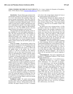
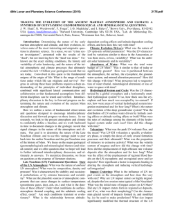
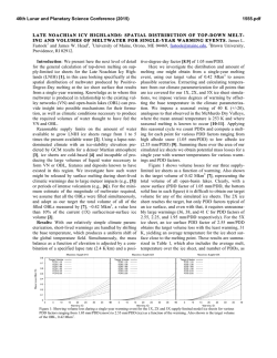
46th Lunar and Planetary Science Conference (2015)
1349.pdf
CURVILINEAR FURROWS ON MARS: HINTS FOR ICEBERG RAFTING?
Esther R. Uceda1, Alberto G. Fairén2, Christoper Woodworth-Lynas3, J. Alexis P. Rodríguez4.
1
Universidad Autónoma de Madrid, 28049 Madrid, Spain ([email protected]); 2Centro de Astrobiología, 28850 Madrid, Spain (agfairen@
cab.inta-csic.es); 3PETRA International Ltd., Newfoundland & Labrador, Canada A0A 2B0; 4NASA Ames, 94035 Moffett Field, CA, USA.
Identification of curvilinear furrows: In past
years, we presented evidence for dump structures and
chains of craters that we interpreted as indication for
iceberg transport and grounding on very cold oceans
on early Mars [1]. Here we add the identification on
HiRISE images of curvilinear furrows which can be
observed in the Hellas Basin (Figs. 1-3). All this data
support the notion of the existence of frigid oceans/
lakes on a “cold and wet” early Mars [2,3].
lake-floor sediments [4,5]. Typical terrestrial scour
marks are often several kilometers long, tens of meters
wide and 0.5 to 5 meters deep [5] consistent with the
dimensions of the furrows we describe here from the
Hellas basin on Mars.
Figs. 1-3: Scour marks (arrows) in Hellas Basin (HiRISE image
PSP_009548_1420). Scale bars = 1 km. HiRISE image credit:
NASA/JPL/University of Arizona.
The furrows are located in elevated areas or on local topographic highs. We interpret these features in
terms of iceberg rafting and grounding. We propose
that the furrows were formed in submerged unconsolidated sediments, when floating ice keels touched down
and displaced loose material to the sides as they continued to move forward, possibly driven by both wind
and water currents.
Terrestrial sea ice and icebergs form scour marks
when draft exceeds water depth and their keels touch
and plough forward through unconsolidated ocean- or
Importantly, evidence of upsteam glaciation in the
form of lateral moraines, terminal moraines, till deposits, and kame and kettle topography is been recently
recognized on Mars [6-8]. Therefore, evidence for
mountain glacial activity required to fed the system is
well preserved.
Alternatives: Alternative formation processes for
the curvilinear features on the surface of Hellas include: (1) Faults. Faults tend to maintain preferential
orientations reflecting bedrock structural trends, and
offsets would be expected where they intersect. Neither of these characteristics are observed in the HiRISE
images of interpreted ice scour marks analyzed so far.
Faults are thus rejected. (2) Fractures/joints. Like
faults, fractures and joints tend to reflect preferential
bedrock structural trends, and may occur in linear
intersecting groups with little or no offset at the intersection points. Strong trends that could be related to
bedrock structure are not seen in the images of proposed ice keel scour features, and the meandering,
curvilinear nature of many marks are evidence against
bedrock control. Fractures and joints are thus excluded.
46th Lunar and Planetary Science Conference (2015)
(3) Collapsed lava tubes. These are generally long,
meandering features that do not usually occur in intersecting groups. They tend to be much wider and deeper
than the proposed scour marks, and typically do not
have raised rims. Collapsed lava tubes are thus excluded. (4) Dust devil marks. Meandering dust devil
tracks are common features over a wide range of latitudes in both hemispheres of Mars. The tracks have no
morphological surface expression unlike scour marks.
Also, the tracks have been observed in the process of
formation from orbit. Dust devils are thus rejected as
the formative process.
Previous studies: Using MGS data, Ormö and
Komatsu [9] also found curvilinear grooves in places
in Hellas basin, and they interpret some of them as
possible ice keel scour marks.
Fossil ice floes up to 45 m thick have been recognized and documented in the Cerberus Fossae region
[10]. Findings from radar profiles indicate these features are between ~50 – 150 m thick [11]. The floes are
not associated with ice scour marks and grounding pits
because such features would be hidden from view
below the fossil ice canopy.
Rice et al. [12] investigated platey and ridged terrain at the mouths of Athabasca and Marte Valles, in
Elysium Planitia. They interpret platey terrain as the
fossil casts of former ice floes and ridged terrain as ice
pressure ridges, emplaced by jökulhlaups (glacial outburst floods). Kettle cratering has also been proposed
to have occurred in Athabasca Vallis [13].
Evidence of ice keel scour marks and ice floe
grounding pits within the Kasei Valles system and
parts of Echus Chasma has been reported [14].
Earth analogues: On Earth, ice scouring of lake
and seafloor sediments by the keels of drifting ice
masses is a common geological process on modern
polar and temperate continental shelves (Fig. 4) and in
seasonally frozen lakes and seas, such as the Great
Lakes, Caspian Sea and alpine lakes [15]. Modern
icebergs impact the seabed up to 350 m depth in terrestrial oceans, though during the Quaternary iceberg
drafts reached extreme values of almost 1000 m [16].
The period of seabed interaction may last from a few
minutes to several months [5].
Scour marks may survive the transition from submergence to exposure above water level, and ancient
features are commonly seen, for example, over large
areas of southern Manitoba and parts of southern Ontario formerly occupied by glacial Lake Agassiz and
glacial Lake Iroquois [17]. They are also found on
several large islands of the Arctic Archipelago (e.g.
King William Island, Victoria island) and are readily
identified from aerial photographs. These relic features
were formed in large pro-glacial lakes and (in the
1349.pdf
Fig. 4. Iceberg keel marks identified 70 miles offshore of Georgetown, South Carolina [21].
Arctic) areas formerly submerged below sea level
some 10,000 years ago [18]. Scour marks preserved in
Pre-Cambrian, Ordovician and Carboniferous/Permian
age glaciomarine sediments have been identified on
exposed bedding plane surfaces in several localities
worldwide [19], and it is known that low sedimentation
rates favor the preservation of scours [20].
An analogue to our interpretation of ice keel scour
marks on Mars is the lengthy scientific debate over the
origin of similar surficial curvilinear features on Earth.
This debate was based largely on the two attributes
common to both the Earth and the Mars interpretations,
namely: (i) the interpretations are based on remotely
sensed data (aerial photographs on Earth), and (ii)
interpretations hinge principally on the significance of
regional patterns and morphology of the features. The
debate concluded with the now accepted interpretation
of the terrestrial features as ice keel scour marks.
References: [1] Fairén, A.G., et al., 41st LPSC, #2478 (2010). [2]
Fairén, A. G. Icarus, 208, 165-175 (2010). [3] Fairén, A. G., et al.
Nature 459, 401-404 (2009). [4] Thomas, G. S. P. & Connell, R. J. J.
Sedim. Petrol. 55, 243-249 (1985). [5] Woodworth-Lynas, C. et al.
Cont. Shelf Res. 11, 939–951 (1991). [6] Davila, A. F. et al. Geology
41, 755-758 (2013). [7] Fairén, A. G., et al. Nature Geoscience, 4,
667-670 (2011). [8] Kite E. S. & Hindmarsh, R. C. A. Geophys. Res.
Lett. 34, L19202, doi:10.1029/2007GL030530 (2007). [9] Ormö, J.
& Komatsu, G. J. Geophys. Res. 108 doi:10.1029/ 2002JE001980
(2003). [10] Murray, J. B., et al. Nature, 434 352-256 (2005). [11]
Orosei, R., et al. LPSC 39, #1866 (2008). [12] Rice, J. W., et al.
LPSC 33, #2026 (2002). [13] Gaidos, E. & G. Marion. J. Geophys.
Res., 108(E6), 5055 (2003). [14] Woodworth-Lynas, C. & J. Y.
Guigné. Oceanography 16, 90-97 (2003). [15] Lewis, C. F. M., &
Woodworth-Lynas, C. Geology of the Continental Margin of Eastern
Canada, 2, 785-793 (1990). [16] Kuijpers, A., et al. Marine Geol.
246, 60-64 (2007). [17] County, E., & Ontario, E. Geographie physique et Quaternaire, 46(2), 189-194 (1992). [18] Woodworth-Lynas,
C. & Guigné, J. Y. Geological Society, London, Special Publications, 53(1), 217-233 (1990). [19] Woodworth-Lynas, C. The geology of ice scour. Ph.D. thesis, University of Wales (1992). [20]
Syvitski, J. et al. Arct. Antarct. Alp. Res. 33, 52–61 (2001).
[21] Hill, J.C., et al., Geology 36, 447-450 (2008).
Acknowledgements: The research leading to these results has
received funding from the European Research Council under the
European Union's Seventh Framework Programme (FP7/20072013), ERC Grant agreement no. 307496.

© Copyright 2026