
A POSSIBLE DIAPIR IN ATHABASCA REGION ON MARS R
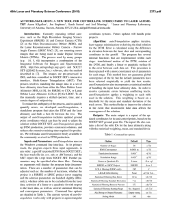
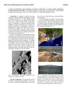
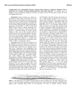
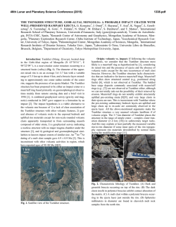
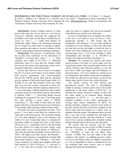
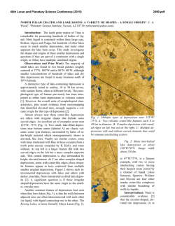
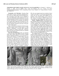
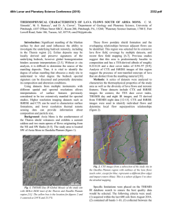
46th Lunar and Planetary Science Conference (2015)
2142.pdf
A POSSIBLE DIAPIR IN ATHABASCA REGION ON MARS
R. Pozzobon1, G. Cremonese1, M. Massironi2 , C. Re1; 1INAF - Osservatorio Astronomico di Padova ([email protected]), 2Dipartimento di Geoscienze, Università degli Studi di Padova
Introduction:
An interesting circular feature has been
observed on Mars by the HiRISE (High Resolution Imaging
Science Experiment) camera on board the NASA’s Mars
Reconnaissance Orbiter (MRO). Located at 0°17'N159°13'E, its diameter is ~2 km and it lies in the Athabasca
region near the equator, in the South-Eastern sector of Elysium volcanic province. In this work, after having reconstructed its topography through photogrammetry, we propose its
possible genesis as an uprising diapir.
geometrical resampling model. As far as the triangulation
stage is concerned, the Ames Stereo Pipeline (ASP) routine
have been used by suitably modifying the Dense Matcher
disparity map to produce an input data in the format accepted
by ASP. Any Bundle Block Adjustment has been performed.
In fig. 2 are displayed 3 DTM profiles, obtained at different
angles. It does not appear a well-defined rim suggesting that
the positive circular morphology might not be formed after
an impact, or the rim has been obscured by embayment and
burial.
Figure 2: DTM profiles generated from HiRISE imagesESP_013249_1805 and ESP_038646_1805 with
Dense Matcher.
Figure 1: Dome-like feature in Athabasca region Wrinkles
all around the circular feature are visible, whereas a craterrim all around the dome is possible, although not certain.
(HiRISE image ESP_013249_1805).
DTM generation: The DTM generation has been performed following a photogrammetric workflow. The files
have been fed into ISIS3 (Eliason, 1997), radiometrically
calibrated and finally the images are ortho-rectified with
cam2map program (i.e. projected onto the reference surface
of the Mars spheroid). The correlation phase have been performed with the Area Based image matching software named
“Dense Matcher” (Re, 2012). The software, developed at the
University of Parma, have been used in order to compute the
image correspondences implementing a disparity map initialization with NCC algorithm (Lewis, 1995) and a sub-pixel
refinement by an advance Least Squares Matching algorithm
(Gruen, 1985) that exploits a polynomial transformation as
Geologic interpretation: The annular wrinkles surrounding the body are not coherent with a lava flow moving
around the rim. In fact in this area most of the lava flows
tend to flow with NW to SE direction and we would have
expected that wrinkled contacts with the rim would concentrate on the direction of the lava flow (as in fact happens with
other impact craters in the same area) or being absent. Instead we can recognize a wrinkled margin all around the
borders of the circular body, that instead seems to be more
coherent with a diapiric ascent deformation. Indeed Subvolcanic intrusions might actually evolve in extruding domes
which can find their way to the surface by breaking apart the
overburden, eventually creating slightly uplifted rims.
We think that being in a volcanic field (near to Elysium planitia, one of the main volcanic centres on Mars) whose main
geological features are volcanic vents and widespread basaltic lava flows, this feature would likely be originated as an
46th Lunar and Planetary Science Conference (2015)
uprising ascent of a subvulcanic body or a salt diapir. Although at the time being there is no spectral evidence of salt
presence in this area, also due to the lack of available CRISM
data, salts mobilization in the dynamic context of such a
volcanic field could still be possible (see Schofield et al.,
2014).
Either being a plutonic body or a salt mobilization, the domelike feature is apparent both from the HiRISE images and
from the Stereo DTM.
A similar object has been found in the north-eastern Orcus
Patera region (fig.3), a volcanic field covered by extensive
lava flows as well.
Figure 3:A dome-like feature similar to Figure 1. in Orcus
Patera region. (P07_003623_1903_XN_10N185W CTX
image).
This second feature, located at 10° 8'N- 174°31'E (fig. 3), it
is similar in size to the former one and ,at the CTX (Context
camera) image resolution (6m/pixel), completely lacks of any
rim-like feature. Its elliptical shape might be related to the
fact that we are not in presence of a possible pre-existing
impact crater that might have focused diapiric ascent as
could potentially be the case in the Athabasca region.
Discussion and conclusions: In a volcanic field context the
presence and uprising of plutonic bodies is likely and widely
seen on Earth. The mechanism of ascent to explain dome-like
features such the ones of figure 1 and 3 would most likely be
the buoyancy forces and the lower density of a magmatic
body. The ∆ρ between the magmatic body and the bed-rocks
is normally enhanced by presence of volatile phases or/and
water/fluids. In addition, we cannot exclude a different and
more evolved composition of a sub-volcanic uprising body
(eg. andesite vs. basalt).
Hence, according to our opinion the features of figures 1 and
3 may have a diapiric origin, either being an intrusive dome
within a volcanic context whose shape and morphology is
coherent with Namibian plutonic domes (e.g. 21°6’S –
14°33’E), or an uprising salt diapir (see Zagros diapir field
26°33’N - 54°40’E) whose topography have a good match
with our HiRISE stereo DTM.
2142.pdf
References: [1] De Pablo, M.A., Komatsu, G., 2008. Icarus
2; [2] Koyi, H. J. Struct. Geol. 20, 321–338 (1998). [3]
Schofield, N. et al. Geology (2014). doi:10.1130/G35406.1;
[4] Sherkati, S. & Letouzey, J. Mar. Pet. Geol. 21, 535–554
(2004). [5] Re C., Roncella R., Forlani G., Cremonese G.,
Naletto G. 2012, Int. Arch. of Photogrammetry, Remote
Sensing and Spatial Information Sciences, Vol XXXIX, Part
IV/7; [6] Vackiner, A. A. et al. 2013, Int. J. Earth Sci. 102,
1701–1716.

© Copyright 2026