
LAVA FLOW FIELDS OF SOUTHERN THARSIS, MARS: FLOW
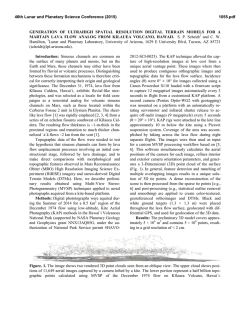
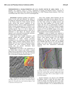
46th Lunar and Planetary Science Conference (2015)
1439.pdf
LAVA FLOW FIELDS OF SOUTHERN THARSIS, MARS: FLOW TYPES, INTERACTIONS, AND
AGES. David. A. Crown1, Daniel C. Berman1, and Michael S. Ramsey2, 1Planetary Science Institute, 1700 E. Fort
Lowell Road, Suite 106, Tucson, AZ 85719, 2Department of Geology and Planetary Science, University of
Pittsburgh, Pittsburgh, PA 15260, [email protected].
Introduction: This research examines styles and
sequences of volcanism in the southern Tharsis region
of Mars. High-resolution images are being used to
produce geologic and flow field maps of the region
south of Arsia Mons and in Daedalia Planum [1-7; see
also 9-11]. Mars Reconnaissance Orbiter Context
Camera images (CTX; ~5 m/pixel) allow
reconstruction of complex volcanic surfaces, including
delineation of individual flow lobes and superposition
relationships within a flow field. Populations of small,
superposed impact craters are used to derive relative
and absolute age constraints for individual flows and
flow sequences.
Study Area and Datasets:
The current
investigation focuses on a zone [22.5-27.5°S, 120130°W] within the extensive flow fields SW of Arsia
Mons for which high-resolution image coverage is
available. CTX images imported into ArcGIS are the
primary image base used to map southern Tharsis flow
fields. In order to fully characterize observed volcanic
features, we also use the Mars Odyssey Thermal
Emission Imaging System (THEMIS) global mosaic
and infrared multi-band images (~100 m/pixel), High
Resolution Imaging Science Experiment (HiRISE; ~25
cm/pixel) images, and Mars Orbiter Laser Altimeter
(MOLA; 128 pixel/deg) DEMs and PEDR profiles.
Flow Types: South of Arsia Mons, flow fields
include numerous prominent, elongate, sinuous lava
flows, many of which can be traced for 100+. Analysis
of CTX images allows identification of two main lava
flow types [1-5, 8]: 1) large, relatively thick, bright
flows with rugged upper surfaces that display medial
channel/levee systems and broad, distal flow lobes.
Ridged, knobby, and platy surface textures are evident;
and 2) small, relatively thin, dark flow lobes with
mostly featureless surfaces that are typically associated
with narrow lava channels or lava tubes. In Daedalia
Planum, wider, less well-defined flow units are evident
and coalesce to form a vast volcanic plain. Large,
ridged, and sometimes platy, sheet flows along with
presumed volcanic plains embay the cratered highlands
at the southern margin of Tharsis [6-7].
Flow Ages: Using CTX images, populations of
small impact craters superposed on lava flow surfaces
have been analyzed and indicate an extensive history
of volcanism across southern Tharsis [5-8] (Figures 12). Crater size-frequency distributions for a series of
elongate flow lobes south of Arsia Mons (including
both bright, rugged and dark, smooth flow types)
indicate ages of ~100 My in the Late Amazonian
Epoch. Crater size-frequency distributions for adjacent
broad flow lobes and for sheet flows further SW in
Daedalia Planum indicate ages ~1+ Gy in the Middle
to Early Amazonian, with older volcanic plains
exposed beneath the sheet flows at the southern margin
of Tharsis. These results suggest a general decrease in
age toward the center of Tharsis and that distinct
sequences of flow emplacement characterize the
Amazonian volcanic history of southern Tharsis.
Flow Interactions and Flow Field Stratigraphy:
CTX images reveal complex flow patterns and local
interfingering and overlapping relationships in the
study area [5]. Distinct embayment relationships are
observed between and among the different types of
flows recognized. Darker channel/tube-fed flows are
commonly younger than the adjacent thicker, bright
flows; however, this is not always the case, and the
observed diversity and complexity of interactions
between flows suggests that lava sources with different
eruptive styles and magnitudes were active
contemporaneously. Further to the SW (and consistent
with the lower slopes) flow lobes widen and large
sheet flows are observed where flows embay the
cratered highlands.
Observed characteristics of the dark flow type
(including smoother upper surfaces, lesser thicknesses,
more numerous, smaller lobes, and their channel/tubefed nature) indicate a lower viscosity lava than for the
bright, rugged flows. Steep-sided and sometimes
terraced margins and the presence of smooth-surfaced
plateaus along lava channel/tube systems suggest
morphologic similarities to inflation signatures in
terrestrial pahoehoe flows [e.g., 12].
In addition, superposition relationships and surface
morphologies within Arsia flow fields suggest
complex interactions between flows; burial of one flow
by another and sharp and gradational contacts between
adjacent flows are apparent. Low viscosity dark flows
are observed to “invade” rugged flow surfaces in
different ways. In some cases, dark flows are captured
by and resurface the lower-lying interior channel zones
of rugged flows. In others, dark flows appear to
inundate rugged flow surfaces but the larger
topographic elements of the underlying rugged flow
surface (e.g., flow ridges and impact craters) are
preserved.
46th Lunar and Planetary Science Conference (2015)
Future Work: Continued analyses of southern
Tharsis lava flow fields will include morphologic and
morphometric investigations of individual flow lobes
and characterization of flow surface textures and
thermophysical properties. Interactions between
flows will be examined to document flow field
stratigraphy. Flow field mapping and chronologic
studies will constrain spatial and temporal patterns in
the voluminous effusive volcanism that characterizes
southern Tharsis.
1439.pdf
References: [1] Crown, D.A. et al. (2009), LPSC XL,
abstract 2252. [2] Crown, D.A. et al. (2010), LPSC
XLI, abstract 2225. [3] Ramsey, M.S. and D.A. Crown
(2010), LPSC XLI, abstract 1111. [4] Crown, D.A. et
al. (2011), LPSC XLII, abstract 2352. [5] Crown, D.A.
et al. (2012), LPSC XLIII, abstract 2138. [6] Crown,
D.A. and D.C. Berman (2012) LPSC XLIII, abstract
2055. [7] Crown, D.A. et al. (2013), LPSC XLIV,
abstract 2499. [8] Crown, D.A. et al. (2014) AGU
2014, abstract P41B-3906. [9] Bleacher, J.E. et al.
(2007), JGR 112, doi:10.1029/2006JE002873. [10]
Lang, N.P. et al. (2009), JVGR 185, 103-115. [11]
Giacomini, L. et al. (2012), Icarus 220, 679-693. [12]
Garry,
W.B.
et
al.
(2012),
JGR
117,
doi:10.1029/2011JE003981.
9
7
9
8
6
2
1
5
4
3
Figure 1 (above). Flow field map of NE Daedalia
Planum region showing lava flow margins (red lines)
and crater count areas for nine flow lobes. Count areas
range from 72 – 6750 km2, and the number of craters
counted for individual flows ranges from 69 – 1456.
Figure 2 (left). Crater size-frequency distributions
grouped by flow type. Results for parts of six elongate,
sinuous flow lobes (red, flows 4-9) show ~100 My
ages (Late Amazonian). Results for parts of three
broad flow lobes (blue, flows 1-3) match the isochrons
at larger crater diameters and indicate ~1 Gy ages in
the Early to Middle Amazonian.
3
2

© Copyright 2026