
Characteristics and Origin of Sinuous Ridges in Solis Planum, Mars
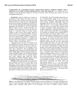
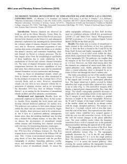
46th Lunar and Planetary Science Conference (2015) 1897.pdf CHARACTERISTICS AND ORIGIN OF SINUOUS RIDGES IN SOLIS PLANUM, MARS. J. Zhao1, J. Huang1, L. Xiao1. 1Planetary Science Institute, China University of Geosciences, Wuhan, 430074, P. R. China ([email protected]) Introduction: Sinuous Ridge (SR) is a curvilinear feature with positive relief, which is also referred to as “raised curvilinear feature” (RCF) [1,2]. More than 1,000 SRs have been identified on martian surface [3,4], most of which concentrate in Aeolis-Zephyria region [1,4-6], Hellas and Argyre basin [7,8], Valles Marineris and nearby chasmata [9.10] and the South Polar region [11,12]. Most of them are explained to form as inverted stream valleys or eskers according to their morphology and geological background [1,12-14]. Here we identified more than 50 SRs in Solis Planum (centered in 270 E,25 S; Fig.1), which is a large lava plain with two main geological units: eHv (Early-Hesperian) in the east and lHv (Late-Hesperian) in the west [15] located in the southeast of the Tharsis region. We analyzed morphology, thermophysical properties and relative ages of these SRs for the first time. We conclude that these SRs are most likely lava tubes in origins. Methodology: We used MOLA (Mars Orbiter Laser Altimeter) gridded data, HRSC (High Resolution Stereo Camera) DTM (Digital Terrain Model) to analyze the topography of the SRs. Images of CTX (Context Camera) were used to generate higher resolution DTM using NASA Ames Stereo Pipeline for small scale topography analysis [16]. In order to examine the detailed morphology and determine the relative ages of the SRs, images of HiRISE (High Resolution Imaging Science Experiment), CTX, HRSC and the visible camera of the THEMIS (Thermal Emission Imaging System) were processed and analyzed. In addition, we used THEMIS nighttime mosaic [17] to access the thermophysical properties of the SRs. Results: Morphology. SRs in the study region vary in length and width. The length of the SRs varies between ~10 to ~750 km. The width of SRs can reach up to 1.6 km, and most of them are hundreds of meters. Their heights are up to 20 meters. Most of the SRs are isolated from adjacent terrains.The topography cross section of the SRs can be classified as seven types: double-ridged, flat-topped ridge, rounded ridge, sharpcrested ridge, trace, trough with a central ridge, and trough (Fig.2). Some single SR can contain one or more cross-sectional types. Some SRs present interesting geomorphology: about 20% of the studied SRs have branches; continuous elliptic collapsed voids and sinuous tumuli. Thermophysical property. In THEMIS nighttime mosaics, an individual SR usually show relatively uniform emissivity. However, the SRs are not always distinguishable from the surrounding plains. As an SR can extend on multiple lava flows with different thermophysical properties, the emissivity of the SR can be higher, lower or identical with the surrounding lava flows. Relative ages. As most SRs are too narrow to perform crater size-frequency distribution measurements, we use stratigraphic relationships to determine the relative ages of the SRs. The SRs distribute in both the eHv and lHv units, which indicates that they formed after the emplacement of Late-Hesperian lava plains. On the other hand, they are partly destroyed by the Late-Hesperian aged wrinkle ridges [18], indicating that the SRs are younger than the wrinkle ridges. Discussion: Previous studies have proposed possible origins of SRs including inverted stream valleys, eskers, glacier moraines, lava flows, wrinkle ridges, dikes, linear dunes, etc [6,11]. Among them, the inverted valley and esker hypotheses are most widely accepted. However, in our study region, there is little evidence such as oxbow lakes and deltas found for the existence of past surface runoff. Meanwhile, the inverted valley hypothesis requires the SRs to be resistant to erosion, while thermophysical properties show that the SRs are not always more resistant than surrounding terrains. On the contrary, in some parts of the SRs, the occurrence of continuous elliptic collapsed voids can indicate a lava tube related origin of the SRs. Besides, sinuous tumuli found along some of the SRs are also supposed to be related to lava tubes [19]. In the case of lava tubes, the SRs are not required to be more resistant than the adjacent terrains. The diversity of cross-sectional shapes of SRs implies that other factors such as regional geological background and related landforms should also be taken into consideration in their formation. Conclusions: We identified more than 50 SRs in Solis Planum and analyzed their morphology, thermophysical properties and relative ages. We proposed the origin of these SRs are most likely to lava tubes. However, other geological processes (e.g. wind, glacier) may have modified their appearence. References: [1] Burr D.M. et al.(2009) Icarus,200, 52-76. [2] Williams R.M.E. et al.(2009) Geomorphology, 107, 300-315. [3] Williams R.M.E.(2007) LPS XXXVIII, Abstract #1821. [4] Williams R.M.E. et 46th Lunar and Planetary Science Conference (2015) 1897.pdf al.(2013) Icarus,225,308-324. [5] Burr D.M. et al. (2010) JGR,115,E07011. [6] Lefort A. et al.(2012) JGR,117, E03007. [7] Kargel J.S. and Strom R.G. (1992) Geology,20,3-7. [8] Banks M.E. et al.(2009) JGR,114, E09003. [9] Le Deit L. et al.(2010) Icarus, 208,684-703. [10] Weitz C.M. et al.(2010) Icarus,205, 73-102. [11] Head J.W.(2000) LPS XXXI, Abstract #1116. [12] Hiesinger H. and Head J.W.(2002) PSS,50, 939-981. [13] Lang N.P.(2007) LPS XXXVIII, Abstract #1116. [14] Zimbelman J.R. and Griffin L.J.(2010) Icarus,205,198-210. [15] Tananka K.L.(2014) Geologic map of Mars.USGS. [16] Moratto Z.M. et al.(2010) LPS XXXXI, Abstract #2364 [17]Edwards C.S. et al. (2011) JGR, 116,E10008 [18] Mangold N.(2000) PSS, 48,1201-1211. [19] Orr T.R. (2014) J. Volcanol. Geoth. Res., in press. Figure. 2 Different appearences of SRs. Context images are from CTX stamps. (a) double-ridged; (b) flattopped; (c) rounded; (d) sharp-crested; (e) trace; (f) trough with a central ridge; (g) trough. Figure. 1 The locations of SRs in Solis Planum. Each yellow dot marks an individual SR.


© Copyright 2026