
Development of Streamlined Islands During Lava
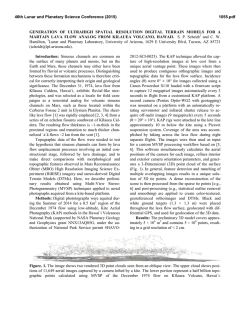
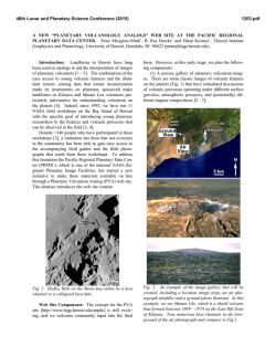
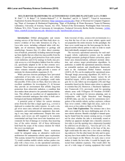
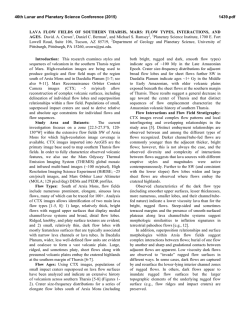
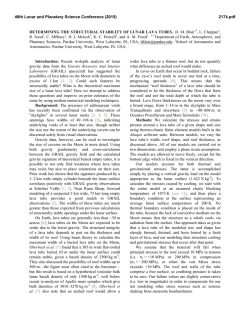
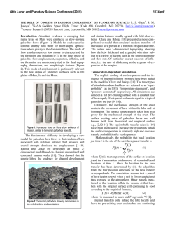
46th Lunar and Planetary Science Conference (2015)
2182.pdf
NO EROSION NEEDED: DEVELOPMENT OF STREAMLINED ISLANDS DURING LAVA CHANNEL
CONSTRUCTION. J.E. Bleacher1, C.W. Hamilton2, S.P. Scheidt2, W.B. Garry1, A. de Wet3, P. Whelley1,4, D.A. Williams5.
1
Planetary Geodynamics Laboratory, Code 698, NASA GSFC, Greenbelt, MD 20771 ([email protected]), 2Lunar and
Planetary Laboratory, University of Arizona, Tucson, AZ 85721, 3Department of Earth and Environment, Franklin & Marshall
College, Lancaster, PA 17603, 4Oak Ridge Associated Universities, Oak Ridge, TN 37831, 5School of Earth and Space Exploration, Arizona State University, Tempe, AZ 85281.
Introduction: Sinuous channels are observed on
Earth as well as the Moon, Mercury, Venus, Mars, Io,
and Titan. Apollo samples showed that fluvial processes
did not form channels on the Moon [1], and subsequent
planetary exploration has unambiguously demonstrated
the volcanic origin of sinuous channels on Venus, Mercury, and Io. However, continued acquisition of new
martian data seems to heighten the debate as to whether
this planet’s sinuous, and sometimes branching, channels formed via fluvial or volcanic processes. The debate largely arises from the morphological equifinality
of these landforms due to some similarities in the
mechanisms of fluvial and volcanic channel formation
[2]. The issue of channel formation tends to focus on
comparisons between the erosive capabilities of lava
and water, but a third scenario must also be considered;
channel formation via lava construction and drainage.
Here we focus on streamlined islands, which can
form in channel networks and are often interpreted to
be the products of erosion by the overland flows of low
viscosity fluids, such as water. However, streamlined
islands can also form in lava channels without the requirement of substrate erosion, and so we investigate
the December 1974 lava flow on KƯlauea Volcano,
Hawai’i, as an analog for the formation of streamlined
islands on Mars and other planetary environments.
Background and Approach: Basaltic lavas are
commonly emplaced as sheet-like flows. In this scenario, basaltic flows inundate the local terrain and may
develop internal preferred pathways for molten lava.
The pathways can coalesce to form main channel stems
within the sheet and are sometimes covered by fragile
crust. Initially, these processes tend to be constructional, but if lava in a preferred pathway subsequently
drains away, then the resulting landform may develop
into a channel-like collapse feature, or lava tube. Here
we discuss the development of streamlined islands
within sinuous and branching lava channel networks
with relevance for interpreting planetary landscapes.
We conducted field work in Hawai’i on the December 1974 lava flow of KƯlauea Volcano [3]. This flow
erupted from en echelon fissures in the KƯlauea SW rift
zone. This ~6 hour event produced numerous overlapping sheets of lava that interacted with the pre-flow
topography to produce branching pathways, confluences, and streamlined islands [3–9], some of which
define a series of streamlined islands. To assess the
subtle topographic influences on flow field development we combined airborne LiDAR [6], ground-based
LiDAR [7] and Multi-View Stereo Photogrammetry
(MVSP) to produce a 3.5 cm resolution Digital Terrain
Model (DTM) for the field site [8].
Results: Our study area is a series of streamlined islands situated at the confluence of two lava pathways
(Fig. 1). Here the flow is bound to the S and SE by the
Koae Fault System and higher topography to the NW.
At this locality, >2 m of relief exists within the sheet,
which likely experienced flow thickening due to filling
of low topography [9]. The pathways are rougher than
the margins of the flow field and have been described
as µDµƗ lava. However, our field observations show that
the channels are composed of meter-sized slabs of disrupted pƗhoehoe crust. Slabby pƗhoehoe often forms
when a crusted pƗhoehoe sheet is disrupted by an increase in flow rate through the sheet’s molten core.
Our study concentrates on two of the smaller islands
that are 10×20 and 20×30 m in size. The smaller island
is flat topped and covered by undisrupted pƗhoehoe
lava. The larger island top is partly covered by folded
pƗhoehoe that wraps around older, unburied lava, which
is tan in color (Fig. 1). The down-flow margins (SW)
display a tapered point characterized by flow lines that
merge. The island’s topography gradually decreases in
height above the surrounding terrain on the tapered end.
The E margin of each island also displays a gradual
decrease in height to the lower topography. However,
the W and N margin of the larger island and S margin
of the smaller island are bound by an abrupt contact
with the rough, disrupted pathways. The margin is defined by a ~2-m-high vertical wall of lava that represents the core of the sheet. The exposed core also shows
tool marks where solidified lava scraped against it
while the core was still somewhat viscous. At the top of
this wall the texture changes to the glassy pƗhoehoe
crust. The crust exhibits cracks where the boundary
transitions from a wall of exposed core to the gradually
depressed surface forming the tapered tail of the island.
The topography across this section of the flow, from
NW to SE shows a consistent elevation of 991 m and a
smooth pƗhoehoe texture (Fig. 1). The topography
gradually decreases by 1 m to the SE and abruptly
drops the remaining 0.5 to 1 m to the rough pathway
floor. The islands mark a 2 m rise in topography before
dropping 1.5–2 m across the eastern pathway. After
crossing the eastern pathway the topography becomes
smooth pƗhoehoe that embays the pre-flow terrain.
46th Lunar and Planetary Science Conference (2015)
Interpretation: The study area within the December 1974 flow was emplaced as a broad sheet-like flow
that filled in a local topographic low near the basal
scarp of the Koae Fault System. This enabled the flow
to attain thicknesses higher than elsewhere across the
flow field. Here the flow reached a hydrostatic surface
at ~991 m elevation. The surface across which the lava
advanced is best described as a hummocky pƗhoehoe
tumulus field, which is typical of low slope basaltic
terrains. Older tan-colored tumuli adjacent to the December 1974 flow are up to 2–3 m in height and the
uncovered portions of this older flow that are also exposed at the top of the larger island, which leads us to
interpret that these islands were anchored by highstanding pre-flow tumuli. As these obstacles were inundated by the December 1974 flow, the lava would have
preferentially cooled around these obstacles to form a
higher viscosity zone beneath a pƗhoehoe crust. Stagnation of these thinner, cooler, and more viscous zones
would then have focused the flow into a series of preferred lava pathways located between the stagnant islands that developed within the once continuous liquid
sheet. Changes in the local discharge rate through the
preferred pathways either due to changes in the discharge rate at the vent or through parts of the lava
transport system would then have disrupted the crust of
the flow above the pathways. Finally, as the local lava
supply waned, partial drainage of the preferred pathways created topographically depressed channels with
rough surfaces, bounded by smoother and higherstanding surfaces anchored to the older tumuli.
The resulting morphology consists of a relatively
smooth flow field with thin margins that is dissected by
rough, depressed pathways or channels. This morphology resembles an erosional surface incised into a
smooth plain by overland flows of low viscosity fluids,
but actually represents an initial constructional process
followed by partial drainage within a viscous lava flow.
Planetary Relevance: Streamlined islands are often
assumed to be the product of erosion by low viscosity
fluids and are used as evidence of aqueous flows. However, lava can also create streamlined islands in a manner that appears to involve incision, but is more easily
explained by flow thickening due to topographic confinement, followed by partial drainage of preferred lava
pathways. This process can be enhanced when sheetlike flows are fed by en echelon fissures and feed multiple pathways weaving their way across the pre-flow
terrain [3]. The final dimensions of the channel network
and streamlined islands are therefore strongly influenced by both the pre-flow topography and local lava
discharge rates, which are affected by vent(s) conditions and modulated by the lava transport system.
The December 1974 event was short-lived and low
volume erupted. Higher volume eruptions could thicken
significantly where obstacles establish large basins to
2182.pdf
be filled. For instance, one such channel in the
Ascraeus Mons SW rift apron on Mars [10] is bounded
by the presence of a large tube-fed ridge. Comparable
ridges elsewhere on Mars reach heights of over 100 m
of relief. Thus, tube-fed ridges provide geologic geometries where fissure-fed sheet flows could fill depressions to 10s of meters and upon draining, channels and
islands with comparable depths and heights.
Consequently, we suggest that branching channel
networks and streamlined islands within fissure-fed
flow fields on Mars could have resulted from a combination of initial flow thickening followed by partial
drainage of preferred lava pathways, and therefore do
not necessarily imply substrate erosion or modification
by fluvial processes.
Figure 1. Top left: Airborne image showing the group
of streamlined islands. Top right: 3-dimensional image
data [8] show a rendered, oblique view of the two islands discussed in this abstract. Bottom: A topographic
profile across the study area is shown with both X and
Y axes measured in meters. Point A is a contact with a
younger flow lobe within the 1974 flow field and Point
B is the existing terrain.
Acknowledgements: Funding for this work was
provided through NASA’s MMAMA, MDAP, PGG
and SSERVI programs. Work was conducted within the
Hawai‘i Volcanoes National Park under National Park
Service science permit #HAVO-2012-SCI-0025.
References: [1] Heiken et al. (1991) Lunar Sourcebook. [2] Leverington (2004) JGR, doi:10.1029/
2004JE002311. [3] Dietterich and Cashman (2014)
JGR, doi:10.1002/2014JF003103. [4] Pollard (1983)
Tectonophysics, 94, 541–584. [5] Lockwood et al.
(1999) USGS Prof. Pap. 1613. [6] Soule and Cashman
(2004) BV, doi:10.1007/s00445-003-0291-0. [7]
Whelley et al. (2015) LPSC 46, #2140. [8] Scheidt and
Hamilton (2015) LPSC 46, #1055 [9] Hamilton et al.
(2015) LPSC 46, #1072. [10] Bleacher et al. (2010)
LPSC 41, #1612.
© Copyright 2026