
late noachian-early hesperian flood volcanism in hesperia planum
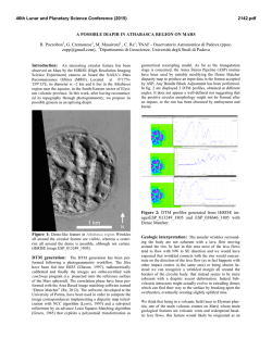
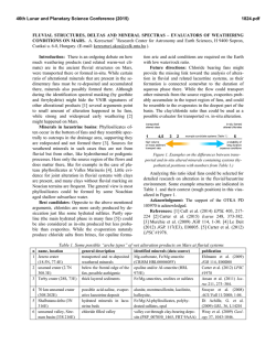
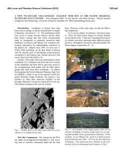
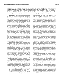
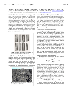
46th Lunar and Planetary Science Conference (2015)
2250.pdf
LATE NOACHIAN-EARLY HESPERIAN FLOOD VOLCANISM IN HESPERIA PLANUM: LARGESCALE LAVA-ICE INTERACTIONS AND GENERATION AND RELEASE OF MELTWATER. James W.
Head and James Cassanelli, Department of Earth, Environmental and Planetary Sciences, Brown University,
Providence, RI 02912 USA ([email protected]).
Introduction: The Late Noachian-Early Hesperian
(LN-EH) represents a time of profound transition in the
geologic [1], mineralogic [2] and climate [3,4] evolution
of Mars characterized by a decrease in bombardment
rate, evidence for water flowing across the surface
(valley networks [5,6] and open-basin lakes [7]), a peak
in volcanic flux [8-10], a major climate transition, and a
major transition in mineralogic weathering style [2].
Two of the major processes are: 1) volcanism, representing the surface manifestation of interior evolution,
and 2) fluvial, representing conditions in the atmosphere
(rainfall/snowfall), and temperature at the surface/near
subsurface (groundwater/cryosphere). What can the
relationship between these two major processes tell us
about conditions during this critical transition period? In
order to address this question, we examine the type area
of the Hesperian Period, Hesperia Planum (HP) (Fig. 1),
a ~3 x 10⁶ km2 area composed of extensive flood
volcanic plains with two major volcanic edifices
(Tyrrhenus and Hadriacus Montes) and evidence of
various volatile-related processes [11-18].
Figure 1. Geologic map of the Hesperia Planum region [1].
We investigate the relationship of the emplacement of
these units with the older surrounding and subjacent
Noachian terrain and related incised valley networks, and
contemporaneous and relatively younger fluvial channels
and associated features within and adjacent to HP. We
document evidence for the state of water in the LN-EH
climate (liquid or solid), and further investigate the
relationship of the volcanic features and deposits to
fluvial features, as has been previously studied [11-13],
and attributed to melting of ground ice by intrusive
volcanism [11-13].
Stratigraphy and Geologic Setting: HP occupies a
broad, relatively flat depression surrounded and
underlain by early and late Noachian cratered highlands
units [1] incised by a series of valley networks that flow
from the highland margins in toward the planum interior
during the LN-EH [5-6]. The earliest distinctive evidence
of volcanism is Tyrrhenus Mons (TM), a Noachian [1]
volcanic edifice in central HP. A second volcanic edifice,
Hadriacus Mons (HM) is located in the SW part of HP.
Both edifices are surrounded by Early Hesperian
volcanic plains (EHVP) [1] that make up the majority of
HP, and show irregular embayment relationships with
the surrounding highlands and valley networks. The
volcanic edifices have been interpreted to represent both
explosive and effusive eruptions [19-21]; the plains are
primarily high-effusion rate flood-basalt eruptions
[10,15,19,22]. Both edifices are heavily dissected by
radial channels, interpreted to be part of the global valley
network systems [5].
Fluvial Activity: Valley networks systems in the
surrounding highlands are generally embayed by lava
plains, although there is evidence for late stage VN
deposits superposing EHVP. Radial VN are superposed
on TM and HM indicating that fluvial activity occurred
during and subsequent to their formation. Similar VN
distributions have been mapped on younger volcanic
edifices in Tharsis and attributed to top-down and
bottom-up heating and melting of superposed snow and
ice deposits [6,23]. Together, these features suggest
significant fluvial erosion occurring during the LN-EH,
during the formation of the LN-EH edifices and the
EHVP. Additional fluvial features (sinuous channels and
tear-dropped-shaped islands) are found within the EHVP.
Late Hesperian fluvial channels are observed on the SW
margin of HP, extending down into Hellas Basin (Fig. 1).
Plains Volcanic Activity and Post-Volcanic Unit
Modification: The EHVP are generally smooth plains
suggestive of flood basalt emplacement, intermingled
with ash deposits from the HM and TM edifices [15-21].
We estimated the thickness of the EHVP by measuring
the diameters of buried and partially buried impact
craters throughout HP (range ~1.8-2.3 km; average ~2
km). A wide range of evidence is seen for modification
of the EHVP surface during and subsequent to
emplacement: 1) Wrinkle Ridges: EHVP are heavily
deformed by a network of wrinkle ridges (WR), which
form polygonal networks that are confined to HP itself,
suggesting
significant
subsidence,
following
emplacement. 2) Collapse/Chaos: These occur inside
flooded impact craters and near the margins of HP
adjacent to areas of VN embayment. 3) Plateaus/Graben:
Tyrrhenus Labyrinthus, an equi-dimensional ~100 km
region of rectangular plateaus and graben in NW HP
suggests that the EHVP surface was highly deformed
inside HP, perhaps in conjunction with WR formation. 4)
Linear Depressions: A broad (~25-50 km wide), several
46th Lunar and Planetary Science Conference (2015)
100 m deep, hundreds of km long trough-like depression
in the EHVP surface extends from central HP to the
south and contains fluvial channels and teardrop-shaped
islands. 5) Channel/WR: In SW HP, several fluvial
channels [5] emerge from WR structures. 6) Scalloped
Flow Margins: At numerous places across HP, flow
margins are largely scalloped in nature, suggesting
modification of flow margins by volatile processes.
Together, EHVP flood-basalt emplacement, the high
degree of internal deformation of the EHVP, and
associated pre-and post-emplacement fluvial activity
strongly suggest a relationship between the two
processes.
Predicted Relationships Between Volcanism and
Fluvial Activity: Two end-member models for the LNEH hydrological system and cycle are: 1) warm and wet
(surface T near or >273K): dominantly vertically
integrated hydrological system with surface meltwater
and groundwater [24,25], and 2) cold and icy (surface T
<<273K): horizontally stratified and a global cryosphere
[3,4]. In the first scenario, moderate temperatures would
allow rainfall and runoff, water would collect in lows,
and percolate into the groundwater system; due to this,
volcano-water interactions would be limited, perhaps to
interaction of rising magma and groundwater in edifices
producing explosive activity [20]. In the cold and icy
scenario, the region would be characterized by snow and
ice deposits [4] that could be up to hundreds of meters in
thickness [26]; five types of volcano-H2O interactions
might be envisioned: 1) Volcanic gas emissions could
raise atmospheric temperature sufficiently to cause topdown melting of snow and ice [27], creating drainage
channels (VN) into the lowlands; 2) Extrusive lava could
interact with surface snow and ice in HP to cause melting
and drainage; 3) Accumulated EHVP lava could serve to
raise the melting isotherm, melting cryospheric ground
ice and causing drainage into the groundwater system
[28]; 4) Accumulated lava could raise the melting
isotherm into surface snow and ice, causing extensive
regional melting [28]; 5) Focused heat sources at HM
and TM could cause localized heat pipe-drainpipe
environments with snow and ice meltwater draining
radially and percolating vertically near the shallow
summit reservoir [29].
Because of the wide array of features suggesting
shallow mass loss and associated fluvial activity, we
examine the cold and icy hypothesis in detail. To
illustrate the relationships between these options, we
assume that a maximum of 2 km of lava is emplaced in a
flood basalt mode, and track the temporal sequence of
effects on surface melting and melting isotherm elevation
with nominal LN-EH heat fluxes [23] (Fig. 2). The initial
emplacement of lava on a ~700 m thick ice surface [26]
results in contact top-down ice sheet melting, but lava
thermal boundary layer thicknesses become sufficient to
dampen this effect rapidly. Upon accumulation of ~1.5
km of lava, the geotherm is raised to the base of the icecemented cryosphere; the ice cement melts, and
2250.pdf
percolates downward into the groundwater system.
Following lava accumulation to the HP average of ~2.0
km, the melting isotherm reaches the top of the
cryosphere after about 200 Ka, and begins to ascend into
the surface snow and ice. Over the next several hundred
thousand years, the melting isotherm ascends into the
snow and ice deposit and melts it. Meltwater can either
percolate into the groundwater system, or be trapped
between the overlying lava and the substrate by an
impermeable layer, such as a lava flow or ash layer.
After about 1 My, the entire 700 m of snow and ice
between the overlying lava flows and underlying regolith
would be melted, producing a total of ~13 m GEL
(global equivalent layer) of meltwater.
Figure 2. Model results showing the thermal evolution of the
cryosphere and ice sheet in response to accumlating superposed lava.
Interpretation
and
Outstanding
Questions:
Formation of many of the HP features documented above
suggests extensive EHVP flood-basalt resurfacing of ~2
km, accompanied/followed by subsidence, tilting,
drainage and breakup across HP, suggestive of removal
of many hundreds of meters of subsurface material.
Associated fluvial activity seen in many instances
suggests melting/drainage of significant volumes of subEHVP ice. Calculations of the thermal evolution of the
EHVP emplacement predicts that the melting of icecemented cryosphere is volumetrically insufficient to
account for such subsidence. Basal melting of buried ice
deposits by raising H2O melting isotherms beneath
superposed EHVP lava flows is the main mechanism that
appears to account for 1) the predicted amount of
melting, 2) the observed amount of subsidence, and 3)
the evidence of associated fluvial features.
References: 1] Tanaka et al. (2014) USGS. SI Map 3292; 2] Bibring et al. (2006) Science 312,
400; 3] Forget et al. (2013) Icarus 222, 81; 4] Wordsworth et al. (2013) Icarus 222, 1.; 5]
Hynek et al. (2010) JGR 115; 6] Fassett & Head (2008) Icarus 195, 61; 7] Fassett & Head
(2008) Icarus 198, 37; 8] Craddock & Greeley (2009) Icarus 204, 512; 9] Greeley & Schneid
(1991) Science 254, 996; 10] Head & Pratt (2001) JGR 106, 12,275; 11] Squyres et al. (1987)
Icarus 70, 385; 12] Crown et al. (1992) Icarus 100, 1; 13] Mest & Crown (2001) Icarus 153,
89; 14] Ivanov et al. (2005) JGR 110; 15] Gregg & Crown (2009) NASA/CP-2010-216680, 27;
16] Mest & Crown (2014) LPSC 45 2793; 17] Mest & Crown (2002) USGS GI Map I-2730;
18] Mest & Crown (2003) USGS GI Map I-2763; 19] Greeley & Spudis (1981) Rev. Geophys.
19, 13; 20] Crown & Greeley (1992) JGR Planets 98, 3431; 21] Kerber et al. (2012) Icarus
219, 358; 22] Head et al. (2006) Geology, 34, 285; 23] Fassett & Head (2007) Icarus 189, 118;
24] Craddock & Howard (2002) GRL 107, 5111; 25] Andrews-Hanna et al. (2007) Nature, 446,
163; 26] Fastook & Head (2014) PSS, in press; 27] Halevy & Head (2014) Nature Geo. 7, 865;
28] Cassanelli & Head (2015) LPSC 46; 29] Cassanelli et al. (2015) PSS, in press.

© Copyright 2026