
EXPLORING SELF-SIMILARITY IN HAWAIIAN LAVA FLOWS. E. I.
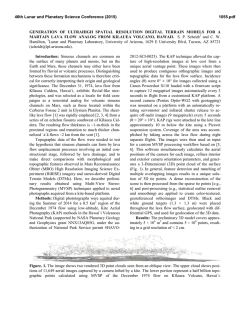
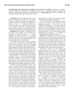
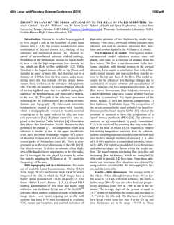
46th Lunar and Planetary Science Conference (2015)
2972.pdf
EXPLORING SELF-SIMILARITY IN HAWAIIAN LAVA FLOWS. E. I. Schaefer1, S. P. Beard1, Y.
JeongAhn1, X. Tan1, and C. W. Hamilton1, 1Lunar and Planetary Laboratory, University of Arizona, Tucson, AZ
85721 USA ([email protected]).
Introduction: The rheology of a lava flow strongly influences its 3D shape and plan-view geometry,
which suggests that the rheology of a lava flow may be
inferred from quantitative analysis of its flow margins.
This insight led Bruno et al. [1,2] to explore whether
the fractal dimension of lava flow margins correlate
with their identification as ‘a‘ā or pāhoehoe—the two
end-members of basaltic lava flows. For such flows,
[1,2] observe a consistent fractal dimension D across a
wide range of scales, indicating that the shape of the
flows is scale-invariant or “self-similar”—that is, basaltic flows are fractals. They also find that D varies between ‘a‘ā and pāhoehoe, as anticipated. Because they
observe this difference at scales as coarse as a few kilometers, fractal dimension analysis holds potential for
inferring lava rheology from coarse planetary datasets,
as Bruno et al. explored for Venus [3].
In this study, we update the analog field techniques
of [1,2] with Differential Global Positioning System
(DGPS) measurements and consider additional flow
types and conditions—including partial mantling by
aeolian sediments and the influences of partial overprinting by later flows—on fractal dimension analysis.
Methods: In the field, we traversed lava flow margins using a Trimble R8 GNSS rover in Real Time
Kinematic mode, which allowed us to continuously
collect points with a sample spacing of as little as several centimeters. This approach is qualitatively similar
to the digitizing technique used by both [1,2] and us to
map lava flow margins in photographs and thus provides a consistent methodology across field and remotely sensed scales.
We then used the “divider method” (also called a
“structured walk”) to calculate how the apparent length
of the margin changes when measured with figurative
rods of different lengths [4,5]. Each such measurement
results in an approximation of the original line with
inter-vertex segments equal to the rod length. These
measurements are then graphed on a log(rod length)
versus log(measured length) plot (Fig. 1). If the measurements have a linear trend on this plot, the flow margin is self-similar with a fractal dimension D = 1 – m,
where m is the slope of the trend [4].
We initially use 5 rod lengths, with each length
twice that of the next largest, consistent with common
practice [2,5]. Because our vertices are approximately
evenly spaced, we use twice this distance for our
smallest rod length, after [4]. Where the first rod is
placed can significantly affect the final measurement,
so we repeat the measurement at each rod length from
50 randomly selected starting points along the flow [4].
Results: All eight of the field traverses that we
have analyzed so far show fractal behavior with R2 >
0.95, using the same criteria adopted by [2]. Also similar to [1,2], we observe this fractal behavior at length
scales spanning a factor of ≥16 for each traverse.
Moreover, in repeated traverses of Muliwai a Pele (a
section of the 1974 A.D. Mauna Ulu ‘a‘ā channel levee
over pāhoehoe), we measure a consistent fractal dimension of 1.06–1.08 from 0.15–16 m with R2 ≥ 0.98.
These results using DGPS are in excellent agreement
with [1,2] who found a fractal dimension of 1.05–1.09
using dowels and chains for a similarly aged ‘a‘ā flow
margin at the same site.
We also find strong (R2 ≈ 0.98) fractal behavior for
the margin of an ‘a‘ā-on-pāhoehoe flow in the Kaʻū
Desert despite significant embayment by sands. The
fractal dimension that we measure here is 1.12, placing
it between the typical ranges for ‘a‘ā (1.05–1.09) and
pāhoehoe (1.15–1.23) identified by [1,2]. In another
two traverses on the coastal plain near the Hōlei Pali,
we measured the margins of two different pāhoehoeon-pāhoehoe flows and find respective fractal dimensions of 1.19 and 1.22 (Fig. 1), again in excellent
agreement with the ranges identified by [1,2]. However, the log-log plot for one of these traverses is noticeably convex-upward and correspondingly R2 = 0.96,
the lowest measured in our study so far. Adopting the
metric used by [2], we note that the coefficient on the
squared term of a least-squares quadratic fit is a =
-0.13 for this flow, compared to a = -0.047–0.01 for all
other traverses.
Discussion: We effectively reproduced the results
of Bruno et al. [1,2] at Mauna Ulu, demonstrating both
the accuracy of their analog methods and the great potential of DGPS to enhance such work. Indeed, we
were able to cover nearly 150 m with an effective rod
size of 15 cm in just 10 minutes. Although [2] also
made at least one traverse with a similar 12.5 cm rod,
they were only able to cover ~20 m due to the tedious
nature of the analog method. Of course, DGPS also has
the advantage of simultaneously recording geographic
coordinates, permitting direct comparison of field and
photographic measurements.
The measured fractal dimension for the flow margin in the Kaʻū Desert is notable because it lies between the typical ranges for ‘a‘ā and pāhoehoe even
though the flow is in fact ‘a‘ā. The most conspicuous
46th Lunar and Planetary Science Conference (2015)
difference between this flow and the others investigated in this study is its partial mantling by aeolian sediments from the surrounding desert. Logically, this
should preferentially remove the finest features, as we
observe. However, the smallest useful rod size for this
traverse is 0.5 m, which may be too coarse to resolve
such smoothing. Indeed, R2 = 0.98 is well above the
threshold suggested by [2], and a = -0.05 reflects only
a mild upward-convexity, suggesting that these
measures alone are insufficient to identify this problematic scenario. A qualitative inspection of the log-log
plot nonetheless suggests a mild change in linear trend
at ~2 m, which supports a tentative inference that the
aeolian sediments are responsible for the ambiguous
value, as anticipated by [2] who expressly investigated
only “simple cases.”
The results for the two adjacent flows on the
coastal plain offer perhaps a greater puzzle (Fig. 1).
Both are relatively fresh pāhoehoe atop mildly vegetated pāhoehoe on very gentle slopes (~1.5°) with negligible topography. Nonetheless, they have the two most
extreme values for R2 (0.995 and 0.955) and nearly the
two most extreme values for a (-0.016 and -0.126) of
all the traverses that we have analyzed so far. Although
neither value is extreme in an absolute sense, the lower
R2 is very near the 0.95 threshold, and [2] note that the
correlation of decreasing R2 and decreasing a is associated with increasingly silicic composition, though there
is no reason to infer such composition here.
We do observe two subtle differences that provide
opportunity for speculation. First, the topography of
the pāhoehoe underlying the atypical flow seems to be
more bulbous and may have been significantly inflated.
Second, we occasionally observe very fresh pāhoehoe,
suggesting that what we walked as a single margin may
have formed during multiple generations.
Combining these two observations suggests a possible scenario beginning with the emplacement and
partial inflation of the oldest pāhoehoe flow followed
by widespread inundation by a younger flow. In places,
this younger flow would have preserved a muted expression of the bulbous surface of the earlier flow, as
we observe. Then, a final pāhoehoe flow of much
smaller volume preferentially flowed into troughs in its
substrate—whether the somewhat muted surface of the
second flow or even rare subaerial exposures of the
bulbous first flow itself. Because these troughs naturally intersect the flow margin at alcoves, these alcoves
would be partially filled with new lava and thereby
smoothed in plan view. However, at larger scales, the
gross margin of the widespread second flow would be
inherited and preserved. If the critical scale of filled
alcoves is ~1 m, this scenario would be consistent with
the fractal dimension measurements.
2972.pdf
Future work: Five additional traverses have yet to
be processed, including a flow that transitions from
slabby pāhoehoe to ‘a‘ā. In addition, we have independently mapped the same flow margins based on 1
m/pixel USGS digital orthographic quadrangle images
which will permit us to explore whether fractal dimension is consistent across an uninterrupted range of
scales from ~15 cm (Mauna Ulu) or ~50 cm (all other
sites) to 100 m, the latter of which is more broadly
relevant for planetary observations. Future field work
will enable us to systematically explore a wider range
of lava flow types and conditions.
Acknowledgements: Work in the Hawai‘i Volcanoes National Park was conducted under National Park
Service science permit # HAVO-2012-SCI-0025. This
material is based in part on work supported by the National Science Foundation Graduate Research Fellowship under Grant No. 2012116373.
References: [1] Bruno B. C. et al. (1992) GRL, 19,
305–308. [2] Bruno B. C. et al. (1994) Bull. Volcanol.,
56, 193–206. [3] Bruno B. C. and Taylor G. J. (1995)
GRL, 22, 1897–1900. [4] Andrle R. (1992) Geomorphology, 5, 131–141. [5] Klinkenberg B. (1994) Math.
Geol., 26, 23–46.
a
b
Fig. 1: a) Typical and b) atypical results for adjacent
pāhoehoe flows. The solid blue and dashed cyan lines
are least-squares linear and quadratic fits, respectively.


© Copyright 2026