
Cycle Superhighway - Transport for London
Transport for London Surface Transport Cycle Superhighway Route 2 Upgrade Environmental Evaluation Report Version: Date: Final v2 January 2015 CYCLE SUPERHIGHWAY ROUTE 2 Environmental Evaluation Report Contents EXECUTIVE SUMMARY ........................................................................................................................................... 4 PROJECT DESCRIPTION & METHODOLOGY ........................................................................................................ 7 PROJECT DESCRIPTION...............................................................................................................................................7 ENVIRONMENTAL EVALUATION METHODOLOGY ............................................................................................................8 CONSULTATION...........................................................................................................................................................8 DETAILED APPRAISAL ............................................................................................................................................. 9 PLANNING AND TRANSPORT POLICY ............................................................................................................................9 BIODIVERSITY .............................................................................................................................................................9 CULTURAL HERITAGE ................................................................................................................................................11 TOWNSCAPE .............................................................................................................................................................14 NOISE AND VIBRATION ..............................................................................................................................................17 DUST AND EMISSIONS TO AIR ....................................................................................................................................20 WATER RESOURCES .................................................................................................................................................22 PHYSICAL FITNESS ...................................................................................................................................................22 JOURNEY EXPERIENCE..............................................................................................................................................23 SUSTAINABLE DESIGN ...............................................................................................................................................24 ENVIRONMENTAL MANAGEMENT ................................................................................................................................24 APPENDIX A: ENVIRONMENTAL EVALUATION REPORT TEMPLATE .............................................................. 26 APPENDIX B: RELEVANT PLANNING AND TRANSPORT POLICIES ................................................................. 37 APPENDIX C: LOCATION OF TREES TO BE REMOVED ..................................................................................... 41 APPENDIX D: EVALUATION OF CONSERVATION AREAS ................................................................................. 43 APPENDIX E: LIST OF LISTED BUILDINGS AND STRUCTURES ....................................................................... 49 APPENDIX F: ENVIRONMENTAL DATA SOURCES ............................................................................................. 54 List of Figures Figure 1 Geographical illustration of Cycle Superhighway Route 2 .............................................................................7 Figure 2 MOL ................................................................................................................................................................9 Figure 3 Sites of Importance for Nature Conservation ...............................................................................................10 Figure 4 Sightings of Protected Species ....................................................................................................................10 Figure 5 Conservation Areas ......................................................................................................................................12 Figure 6 Listed Buildings and Structures ....................................................................................................................13 Figure 7 Archaeological Priority Areas .......................................................................................................................13 Figure 8 Streetscape Character Areas .......................................................................................................................15 Figure 9 Important Area for Noise ............................................................................... Error! Bookmark not defined. Figure 10 Do-Minimum vs. Do-Something at Opening 2016 ......................................................................................19 Figure 11 Areas of Air Quality Standard Exceedence ................................................................................................20 Figure 12 Change in NOx Emissions..........................................................................................................................21 Figure 13 Flood Risk Zones........................................................................................................................................22 List of Tables Table 1: Summary of Environmental Impacts ...............................................................................................................6 Table 2 Streetscape Character Areas ........................................................................................................................15 Table 3 – Noise Impact by Road Length ....................................................................................................................18 Table 4 - Do-Minimum vs. Do-Something at Opening year 2016 ...............................................................................19 Table 5 - NO2 Impact by Road Length........................................................................................................................21 Table 6 NOx Emissions from Affected Road Links...................................................... Error! Bookmark not defined. Page 2 of 54 CYCLE SUPERHIGHWAY ROUTE 2 UPGRADE Author(s) and Contributor(s) Sophia Borgese (B.Sc.), Strategy Planner, Surface Transport Environment Team Giovanni Nacci (B.Sc. M.Sc. AIEMA), Principal Technical Specialist - Environment, Surface Transport Environment Team (Acting as Environmental Manager) Page 3 of 54 Environmental Evaluation Report CYCLE SUPERHIGHWAY ROUTE 2 UPGRADE Environmental Evaluation Report Executive Summary Introduction This document presents the outcomes of the environmental evaluation of Cycle Superhighway Route 2 Upgrade (i.e. the Project). It includes a brief description of the Project, the evaluation methodology that has been used, the likely environmental impacts of the Project and measures to protect the built and natural environment. The environmental evaluation follows Surface Transport’s Project Environmental Evaluation procedure, part of its Environmental Management System. Where applicable, the environmental evaluation is guided by the Department for Transport’s Analysis Guidance (TAG) and Design for Roads and Bridges (DMRB). Summary of Impacts Significance of Impacts The Project is likely to lead to localised and route-wide beneficial and adverse environmental impacts; these impacts range from minor adverse to moderate beneficial, including many areas where the Project is likely to have a neutral impact on the environment. The environmental evaluation has concluded that the Project is unlikely to have significant environmental impacts on the following areas: Planning and Transport Policy Biodiversity Cultural Heritage Townscape Noise and Vibration Water Resources Physical Fitness Journey Experience Sustainable Design Environment Management The noise assessment concluded that eleven links are predicted to experience a change in Basic Noise Level (BNL) values of 1 dB or more in the opening year of the scheme, with seven links showing increases in noise (minor adverse effect likely) and four links showing decreases in noise of 1 dB or more after the scheme is operational (minor beneficial effect likely). None of these changes are greater than 3 dB and so are minor. Within the Important Areas for noise, there are not expected to be any changes greater than 1 dB so these changes are negligible. Emissions of nitrogen oxides and PM10 particles are expected to decrease marginally with the Project. Minor adverse impacts are expected on 2.8 km of road, minor beneficial impacts on 0.5 km of road and moderate beneficial impacts on 0.2 km of road. Although a moderate beneficial impact is generally considered to be significant, in light of the small amount by which the minor/moderate threshold is exceeded, the small area affected and the much greater area with minor adverse impacts, the Project is not considered to have significant beneficial or adverse impacts overall. It can be seen that the route has limited potential to cause significant environmental effects. Page 4 of 54 CYCLE SUPERHIGHWAY ROUTE 2 UPGRADE Environmental Evaluation Report The next paragraphs and Table 1 below summarise the main environmental impacts of the Project during the construction and operational phase. Operational phase Benefits The Project is likely to have a number of route-wide benefits, for instance it supports a number of local, regional and national policies which aim to encourage cycling and the use of more sustainable modes of transport. The Project is also likely to improve cyclists’ journey experience and their physical fitness. The Project is likely to have a number of localised benefits particularly in terms of noise and air quality. For instance 4 road-links would experience a reduction in noise over 0.63 km of road. Localised air quality benefits are likely on 0.65 km of road. Disbenefits There are no route-wide disbenefits. Where disbenefits are likely to arise, these tend to be of a localised nature. For instance there will be localised disbenefits to biodiversity where trees will be felled. The loss of trees will also lead to disbenefits to Cultural Heritage where trees are part of a Conservation Area (i.e. Stepney Green Conservation Area) and disbenefits to the Townscape where the loss of trees will degrade the look of the urban fabric. A total number of 22 street trees has been identified for removal, further loss of trees may be at stake if mitigation measures are not implemented, these include for example raised cycleway ramps in the proximity of trees and tree roots. Further localised noise and air quality disbenefits are likely to occur as a result of redistribution of traffic at certain locations; however these changes are not significant. Energy consumption from wayfinding monoliths will have a negative impact on energy efficiency objectives. Construction phase During the implementation works, some slight temporary and localised adverse impacts will arise in the form of visual intrusion, energy consumption, waste production, dust, emissions to air, noise, vibration and disruption to the existing and other cycle routes. Page 5 of 54 CYCLE SUPERHIGHWAY ROUTE 2 UPGRADE Environmental Evaluation Report Table 1: Summary of Environmental Impacts Construction Operational Scale Phase Phase Planning and Transport Policy (p.9) 0 + Route-Wide Biodiversity (p.9) - 0 to - Local Cultural Heritage (p.11) 0 to - 0 to - Local Townscape (p.14) 0 to - 0 to - Local Noise and Vibration (p.17) - + to - Local Dust and Emissions to Air (p.20) - ++ to - Local Water Resources (p.22) 0 0 Route-Wide Physical Fitness (p.22) 0 + Route-Wide Journey Experience (p.23) - ++ Route-Wide Sustainable Design (p.24) - 0 to - Local Key: ---- Slight Adverse Mode Adverse Significant Adverse O Neutral + ++ +++ Slight Beneficial Moderate Beneficial Significant Beneficial Page 6 of 54 CYCLE SUPERHIGHWAY ROUTE 2 UPGRADE Environmental Evaluation Report Project Description & Methodology Project Description The Project is an upgrade to Cycle Superhighway Route 2 between Bow Roundabout and Aldgate. The Route (i.e. the geographical area along which the Project will operate) is approximately 4.5km in length. The eastern end of the route is the junction of the A12 Blackwall Tunnel Approach and the A11 Bow Road on the border of the London Boroughs of Tower Hamlets and Newham. The western end of the route is the junction of A11 Whitechapel High Street and A1211 Mansell Street on the border of the London Borough of Tower Hamlets and the City of London. The Project is located in the London Borough of Tower Hamlets. The Project runs exclusively on the Transport for London Road Network (TLRN) with each end of the route bordering roads managed by the London Borough of Newham and the City of London. Figure 1 shows the geographical extent of the Project. Figure 1 Geographical illustration of Cycle Superhighway Route 2 The Project will aim to deliver the following measures where appropriate: Cyclist segregation from general traffic on the entire Route Advanced Stop Lines (ASLs) Safety mirrors at left turns De-cluttering Improved lighting Planting Page 7 of 54 CYCLE SUPERHIGHWAY ROUTE 2 UPGRADE Environmental Evaluation Report Improved pedestrian facilities Way-finding Cycle Parking Early starts for cyclists Cycle specific stages at junctions Coach and bus stop bypasses Two stage right turns for cyclists Environmental Evaluation Methodology The environmental evaluation of the Project follows Surface Transport’s Project Environmental Evaluation Procedure, part of its Environmental Management System. Where applicable, the environmental evaluation is guided by the Department for Transport’s Analysis Guidance (TAG) and the Highway Agency’s Design for Roads and Bridges (DMRB). Appraisal methodologies are discussed in more detail under each relevant section. This Environmental Evaluation Report defines the requirements for achieving the appropriate level of environmental evaluation for a project so that negative environmental impacts are understood and minimised, environmental benefits are enhanced, environmental risks are managed, challenges to the project are reduced and the required relevant environmental opinions, directions, consents, permits and licenses are identified. The Report provides assurance to the Project Manager, Client and Environmental Manager that the project’s design and performance, the appraisal, monitoring and sampling methodology used, and other technical and reporting activities are of the required quality and standard to meet TfL’s environmental obligations. This report has been adapted from the Environmental Evaluation Report Template shown in Appendix A: Environmental Evaluation Report Template Consultation Consultation involving key stakeholders has taken place from the end of September 2014 to the beginning of November 2014. Page 8 of 54 CYCLE SUPERHIGHWAY ROUTE 2 UPGRADE Environmental Evaluation Report Detailed Appraisal Planning and Transport Policy The Project is consistent and in accordance with national, regional and local planning and transport policy objectives which seek to achieve a more sustainable transport system by promoting cycling (Appendix B: Relevant Planning and Transport Policies). The Project complements other existing and proposed initiatives such as other Cycle Superhighways, the London Cycle Network, Legible London, London Cycle Hire Scheme and The Mayor’s Vision for Cycling in London. The Project will therefore result in slight beneficial effects on planning and transport policy. Biodiversity There are four key biodiversity elements along the Route, these are: Metropolitan Open Land (MOL), Sites of Importance for Nature Conservation (SINCs), protected species and street trees. MOL designation is unique to London and benefits from the same level of protection as Green Belt. As such MOL is the most important green space along the Route. The Route runs through Mile End Park MOL and under the ‘Green Bridge’ which connects the two sides of the park. The route also runs 220m from Tower Hamlets Cemetery MOL (Figure 2). Figure 2 MOL SINCs are the next most important green spaces along the Route. They form part of a national network of non-statutory valued natural sites of Metropolitan, Borough or Local importance. Figure 3 displays SINCs in the area surrounding the Project. Page 9 of 54 CYCLE SUPERHIGHWAY ROUTE 2 UPGRADE Environmental Evaluation Report Figure 3 Sites of Importance for Nature Conservation A number of protected species have been sighted along the Route (Figure 4). These are animals and plants which, as a result of their rarity, vulnerability or persecution, are given some form of special protection through wildlife legislation. Species which may be found on the highway and therefore at potential impact from the Project are birds and bats which may nest or roost in street trees. Figure 4 Sightings of Protected Species There are a large number of street trees along the Route. Trees are extremely important in an urban environment as they not only provide habitat sites for a number of protected species, but Page 10 of 54 CYCLE SUPERHIGHWAY ROUTE 2 UPGRADE Environmental Evaluation Report they also improve the visual appearance of an area. Trees also contribute towards the reduction of atmospheric particulate matter (PM10) and help adapt to climate change. Preliminary design indicates that 22 street trees will be removed; the location of these is shown in Appendix C: Location of Trees to be An additional 19 trees are at risk of felling from the cutting back of footways if mitigation measures such as raised cycleway ramps in the proximity of trees and tree roots are not fully adopted. The Mile End Waste, a wide verge containing many mature trees is currently not under threat; however design changes need to be mindful of not encroaching on this area. Protected species may be affected as a result of tree removal. TAG helps determine the impact that a project may have on biodiversity by combining the nature conservation value of an environmental feature in this case the 22 street trees with the magnitude of a project’s impact. The conservation value of the 22 trees is of high or medium importance at the local scale with a limited potential for substitution, the magnitude of the impact on the tree stock in the area is minor negative. Therefore the overall impact is Value (high or medium) + Magnitude (minor negative) = Slight Adverse The impact on biodiversity may worsen if further trees are to be felled. There are also a number of trees that whilst not at risk they are in close proximity to the works. The potential adverse impact to these trees must be noted and appraised prior to the commencement of the works. The National Joint Utilities Group’s (NJUG) ‘Guidelines for the Planning, Installation and Maintenance of Utility Apparatus in Proximity to Trees’ and the British Standard ‘BS 5837:2005, Trees in relation to construction – Recommendations’ states that within the prohibited zone (i.e. one metre from the tree trunk) excavation of any kind must not be undertaken unless there has been full consultation with the TfL Arboricultural and Landscape Manager. Removal of trees must be agreed with TfL Arboricultural and Landscape Manager. Trees in Conservation Areas must not be felled unless the Local Authority has been notified. The contractors will be required to produce an Environmental Management Plan through which they will seek to ensure that biodiversity features along the Route are protected and that a neutral impact on biodiversity is maintained during the implementation of the Project. If protected species are present during works, TfL will ensure that only Defra licensed ecologists handle protected species. The Project Team has and will be in contact with the TfL Arboriculture and Landscape Manager for the area throughout the development of the Project. The window for carrying out ecological surveys (Spring and Summer) has elapsed. Whilst there is no risk of nesting birds in Autumn and Winter – when the trees are likely to be felled – there may be a risk of removing bats or their roosts. Therefore an Ecological Clerk of Works may be required during the tree felling stage. Cultural Heritage There are a number of heritage designations, features and assets along the Route. These include Conservation Areas (Figure 5), Archaeological Priority Areas (Figure 7), Listed Buildings and Structures (Figure 7), Scheduled Monuments and World Heritage Sites. Page 11 of 54 CYCLE SUPERHIGHWAY ROUTE 2 UPGRADE Figure 5 Conservation Areas Page 12 of 54 Environmental Evaluation Report CYCLE SUPERHIGHWAY ROUTE 2 UPGRADE Figure 7 Archaeological Priority Areas Figure 6 Listed Buildings and Structures Page 13 of 54 Environmental Evaluation Report CYCLE SUPERHIGHWAY ROUTE 2 UPGRADE Environmental Evaluation Report ‘Appendix D: Evaluation of Conservation Areas’ lists all Conservation Areas along the route and provides a brief description of each together with an appraisal of the likely impacts of the Project. ‘Appendix E: List of Listed Buildings and Structures’ lists nationally and locally Listed Buildings and Structures along the Route. The western and eastern ends of the Route are within Archaeological Priority Areas. No World Heritage Sites or Scheduled Monuments are found along or adjacent to the Route. Overall, the impact of the Project on cultural heritage during implementation and operation is expected to be neutral to slight adverse impact. This conclusion was derived by applying professional judgment guided by TAG In most conservation areas the impact is likely to be neutral as the project maintains the existing historic character of the townscape; has no appreciable impacts, either positive or negative, on any known or potential heritage assets; and does not result in severance or loss of integrity, context or understanding within the historic landscape. In the Stepney Green conservation area the impact is likely to be slight adverse. The removal of street trees may impact on the significant urban boulevard which characterises the conservation area. This therefore goes against local policies for the protection of the local character of the historic environment and damages locally significant historic environmental features. Trees in conservation areas are protected, notice must therefore be given to the Local Authority before trees are felled. If more extensive tree removal is to take place, including encroachment on the Mile End Waste the impact on heritage is likely to worsen. New way-finding street furniture, blue Cycle Superhighway branding and lighting upgrades are not likely to impact on the current heritage status of the Conservation Areas. Some excavation may be required particularly when relocating stats and utilities. Required excavation is likely to be under 45cm and therefore have a neutral impact on archaeological remains. In London, archaeological remains tend to be found at a depth greater than one metre from the surface (with the exception of some ancient walls and Scheduled Ancient Monuments which are protected from the surface). If any excavation is to be over one metre, then the contractors will be expected to hand-dig the site if in an archaeological priority area. If archaeological remains are found, work shall stop and will only resume after approval from the relevant Local Authority Conservation Officer is received. The contractors will be required to produce an Environmental Management Plan through which they will seek to ensure that cultural heritage features along the Route are protected and that a neutral impact on cultural heritage is maintained during the construction of the Project. Townscape The Project is located within four broad townscape character areas identified in Figure 8 and described in Table 2 The road along the route is densely populated and made up of 4 lanes of traffic with bus lanes in both directions for almost the entire route. Page 14 of 54 CYCLE SUPERHIGHWAY ROUTE 2 UPGRADE Environmental Evaluation Report Figure 8 Streetscape Character Areas Table 2 Streetscape Character Areas Area A B C Streetscape Urban civic, retail and commercial Urban civic and commercial with a market and transport interchange Urban civic, retail and commercial and small parkland area Definition Description This area is dominated by commercial office buildings of both traditional and contemporary style. It is also a typical high street area. Streets are enclosed by buildings of varying stature and style, from residential properties to purpose-built retail outlets. There are high volumes of pedestrians around transport interchanges which peak at rush hour and lunch time. Footway widths are generally maximised to cater for these high pedestrian volumes. Area A (between Mansell St and Vallance Road) is a 920m stretch of road with four lanes and a bus lane in each direction. It has the character of an urban civic, retail and commercial area with shop frontages along most of the route. The key social hub of this section is the East London Mosque and Altab Ali Gardens. Towards the west of area A the buildings are commercial office space This area is dominated by commercial office buildings of both traditional and contemporary style. The wide pavements are lined with market stalls. There are high volumes of pedestrians around transport interchanges which peak at rush hour and lunch time. Footway widths are generally maximised to cater for these high pedestrian volumes. Area B (between Vallance Rd and Cambridge Heath Rd) is a 460m stretch of road with a bustling daily market, Whitechapel underground station on the north side and The Royal London hospital on the south. This section also has four lanes of traffic with a bus lane in each direction. The first of four Cycle Hire stations on the Route is in front of the Hospital. This area is dominated by commercial office buildings of both traditional and contemporary style. It is also a typical high street area. Streets are enclosed by buildings of varying stature and style, from residential properties to purpose-built retail outlets. There are Area C (between Cambridge Heath Rd and Globe Rd) is a 730m stretch of road with four lanes including a bus lane in each direction, it is characterised by three to four story urban residential properties with shop Page 15 of 54 CYCLE SUPERHIGHWAY ROUTE 2 UPGRADE high volumes of pedestrians around transport interchanges which peak at rush hour and lunch time. Footway widths are generally maximised to cater for these high pedestrian volumes. A small area of parkland also separates the shop fronts from the road. D E Urban residential set back from the carriageway with parkland Urban residential with occasional shop frontages Environmental Evaluation Report frontages on the ground floor. The notable exceptions to this are the Anchor Retail Park and a 10m wide green strip to the east of Cambridge Heath Road which runs for 300m between the road and properties. There are numerous street trees and the area has an inner city ambiance. Streets are enclosed by buildings of varying stature and style, from residential properties to purpose-built retail outlets. Parkland Footway widths are generally maximised to cater for these high pedestrian volumes. Area D (between Globe Road and Grove Road) is characterised by four to eight story buildings, with a suburban residential character. Set back from the main carriageway by a wide and often tree lined pavement with occasional gardens. There are groups of two or three shops at intervals along the Route. A key historical and societal feature along this route is Queen Mary University. The route also passes through Mile-End Park and the iconic green bridge, an important green space for the area. The road is four lanes, often with bus lanes on both sides of the road. Streets are enclosed by residential buildings of varying stature and style. Occasional small shops appear along the route. Like Area D Area E (between Grove Road and A12) is characterised by four to eight storey buildings, with a suburban residential character. There are groups of two or three shops at intervals along the Route. There are also some key historical and societal features along this route; Bow Church listed building, The Thames Magistrate Court and St Clements Hospital. The road is four lanes, often with bus lanes on both sides of the road. Overall, the impact of the Project on the townscape during the operational phase is expected to be between neutral to slightly adverse depending on the location. This conclusion was derived by applying professional judgement guided by TAG. TAG describes a project to have a neutral effect on townscape when it: Avoids neither being visually intrusive nor has an adverse effect on the current level of tranquillity (where these exist) of the townscape through which the route passes. Maintains existing townscape character in an area which is not a designated townscape, that is, neither national nor local high quality, nor is it vulnerable to change. Avoids conflict with government policy towards enhancing urban environments. Page 16 of 54 CYCLE SUPERHIGHWAY ROUTE 2 UPGRADE Environmental Evaluation Report These statements apply to the project along much of the route where the carriageway is already demarcated by the cycle superhighway lanes, bus lanes and is occupied by a large volume of traffic and street furniture. The townscape is already subject to stress conditions and the proposed measures are not expected to worsen them. In other locations along the route the Project could result in slight adverse impacts to the townscape. TAG describes a project to have a slight adverse effect on townscape when: Although not very visually intrusive, will impact on certain views into and across the area. Affects an area of recognised townscape quality Conflicts with local and national policies to enhance the urban environment These statements may apply in areas where trees will be removed, particularly in conservation areas. Some temporary and localised visual intrusion from the construction phase will have a slight adverse impact on townscape. Overall the Project is expected to have a slight adverse impact on townscape during the construction phase due to the traffic diversions and the consequent disruption to travel. In addition disruption could be worsened as a result of cumulative impacts from the simultaneous implementation of other projects in the area. During the operational phase, depending on location, the Project is expected to have a neutral to slight adverse impact. Operational impacts could worsen if the number of trees lost increases. Noise and Vibration The Route passes through some densely populated areas; some of which have been identified by Defra as Important Areas for Noise. These are areas where high traffic volumes meet high numbers of noise sensitive receptors (Figure 9). Page 17 of 54 CYCLE SUPERHIGHWAY ROUTE 2 UPGRADE Environmental Evaluation Report Figure 9: Important Areas for Noise in pink, with the proposed CS in blue A high level noise assessment for short term impacts was carried out by Aecom following DMRB. Results show that the likely impact of the Project on noise ranges from Minor Beneficial to Minor Adverse as shown in Table 4 and Figure 10. The table shows road links where there is a change in Basic Noise Level (BNL) of over 1dB. Changes less than 1dB are deemed to be negligible. Changes between 1dB and 2.9dB are deemed to be minor. Changes between 3dB and 4.9dB are deemed to be moderate. Changes above 5dB are deemed to be major (Table 3). Table 3 – Noise Impact by Road Length Impact Road Length (m) Major Beneficial 0 Moderate Beneficial 0 Minor Beneficial 630 Minor Adverse 1,420 Moderate Adverse 0 Major Adverse 0 Page 18 of 54 CYCLE SUPERHIGHWAY ROUTE 2 UPGRADE Environmental Evaluation Report Table 4 - Do-Minimum vs. Do-Something at Opening year 2016 Figure 9 Do-Minimum vs. Do-Something at Opening 2016 In total there are 11 road links where noise changes by more than 1dB; 7 links will experience an increase in noise whilst 4 would experience a reduction in noise. At all 11 links the magnitude of impacts are minor. The noise assessment at this stage has not identified the location of sensitive receptors and the impact on noise on those sensitive receptors. Some localised short-term slight adverse impacts on noise and vibration can be expected during the construction phase from the use of plant and vehicles. Appropriate mitigation measures that seek to minimise noise during this phase will be put in place by the contractors. The contractors will be required to produce an Environmental Page 19 of 54 CYCLE SUPERHIGHWAY ROUTE 2 UPGRADE Environmental Evaluation Report Management Plan through which they will seek to minimise noise and vibration during the implementation phase. Dust and Emissions to Air Part of the Route passes through areas which exceed air quality standards (Figure 11). Figure 10 Areas where Air Quality Standard Exceeded A high level air quality assessment was carried out by Aecom following DMRB. Results show that the likely impact of the Project on air quality ranges from Moderate Beneficial to Slight Adverse as shown in Table 5 and Figure 12. Page 20 of 54 CYCLE SUPERHIGHWAY ROUTE 2 UPGRADE Environmental Evaluation Report Table 5 - NO2 Impact by Road Length Significance of Impact Number of Links Road Length (m) Substantial adverse Moderate adverse Minor adverse Negligible Minor beneficial Moderate beneficial Substantial beneficial Number of Links 0 0 16 4 8 2 0 Road Length (m) 0 0 2,792 821 466 179 0 Figure 11 Change in NOx Emissions The assessment focuses on the road links with a change of more than 1,000 AADT, as changes in local air quality are considered negligible below this threshold (Source: DMRB). Overall, 2.8km of road is expected to have adverse impacts and 0.65km to have beneficial impacts. Overall, the CS2U is not deemed likely to have a significant air quality impact due to the small changes in traffic flow, emissions and concentrations are expected as the traffic redistributes on the road network. Some localised short-term slight impacts on local air quality can be expected during the implementation phase from the use of plant and vehicles. The contractors will be required to produce an Environmental Management Plan through which they will seek to minimise dust and emissions to air during the implementation phase. TfL will Page 21 of 54 CYCLE SUPERHIGHWAY ROUTE 2 UPGRADE Environmental Evaluation Report require the contractor to comply with the Greater London Authority and London Councils’ Control of Dust and Emissions from Construction and Demolition Best Practice Guidance. Water Resources Apart from Bow Road A12 junction at the north east end of the route, none of the route lies in areas identified by the Environment Agency as being at risk of flooding. Figure 13 displays Flood Risk Zones. The project crosses 2 watercourses, the Bow Back Waters and the Grand Union Canal. There may be a net increase of impermeable surfaces as a result of the removal of trees and this may affect the reliability of drainage along the route. It is uncertain at this stage where replacement trees will be planted. Overall the impact of the Project on the water environment is expected to be neutral. TAG describes a project to have a neutral impact on water when there is no appreciable effect, either positive or negative, on the identified attributes. The contractors will be required to produce an Environmental Management Plan through which they will seek to avoid any impact to the water environment during the construction phase. Figure 12 Flood Risk Zones Physical Fitness TAG advises that significant improvements in fitness and well-being are most evident in those who cycle 30km or more per week and that those people taking up physical activities will receive greater health benefits than those partaking in physical activities already. Page 22 of 54 CYCLE SUPERHIGHWAY ROUTE 2 UPGRADE Environmental Evaluation Report The Project will complement other cycling initiatives but will not lead to an immediate increase in cycling trips; therefore the Project will have an initial neutral effect upon physical fitness. However, increased health benefits can be expected as the Project generates additional cycling trips in future. TAG does not provide a seven point impact appraisal scale for Physical Fitness. However, using professional judgment a conservative slight beneficial impact of the Project upon physical fitness can be expected. The number of cycling trips and associated health benefits will ultimately depend upon individuals’ personal choices. Nonetheless, the overall potential health benefit of the Project is clear, especially if the cycling activity is complemented with other physical daily activities such as walking. Journey Experience Different types of townscapes and the cycle routes in them provide different journey experiences to cyclists. For example canal, park and off-carriageway routes provide a better journey experience compared to on-carriageway routes. Journey experience of cyclists along the Route is evaluated in accordance with TAG Journey Ambience methodology. TAG identifies three components that contribute to journey experience. These are Traveller Care (cleanliness, facilities, information and environment), Traveller Views and Traveller Stress (frustration, fear of potential accidents and route uncertainty). It is expected that Traveller Care along the Route will be improved during the operational phase of the Project, in particular: Cleanliness – The Route will benefit from the proposed enhanced maintenance and enforcement measures. Local Authorities will continue to be responsible for litter collection and cleansing along the Route. Facilities – The route will now be fully segregated and resurfaced. It will be maintained to a high standard. Information – Way-finding monoliths and additional signage will be out in place to provide information about the Route and the local area. Maps of the Route will be available online to help cyclists plan their journeys. Environment – The overall condition and smoothness of cycle rides is expected to be improved from the resurfacing of the Route and Route segregation Views along the Route range from “restricted” (views are obscured by vegetation, fencing or buildings) to “no view” in more built up areas (views are obscured either side of the road by buildings). Overall, it is expected that the Project will have a neutral effect on Travellers Views during the operational phase. The majority of the route is on carriageway and the route will not improve views of the area or hinder them. Travellers Views in the more built up areas may be further improved through measures such as landscape improvements and tree planting if possible. Page 23 of 54 CYCLE SUPERHIGHWAY ROUTE 2 UPGRADE Environmental Evaluation Report It is expected that during the operational phase the Project will have a positive effect on Traveller Stress. The positive benefits are identified through the alleviation of three recognised causes of travel stress: Frustration – Congestion, road layout and geometry and the inability to make good progress along the route are usually causes of frustration. Route resurfacing and segregation will help to reduce frustration. Fear of potential accidents – One of the key objectives of the Project is to improve the image and perception of cycling, safety and the perception of safety. These objectives will be achieved by implementing measures such as Cycle Superhighway branding and segregation that will increase visibility of the Route to other road users. These measures combined with Smarter Travel measures such as led rides, cycle support for school leavers and HGV and freight driver training will help reduce fear of potential accidents. Route uncertainty – Route uncertainty would be improved through the implementation of distinctive blue branding and segregation. The Route will be signed with way-finding monoliths providing key information such as route number and average journey times to destinations. Proposed landscape improvements and lighting features are desired to provide continuity to the route but again the implementation of these is uncertain at present. Overall the Project is going to be moderate beneficial to journey experience for cyclists During the construction phase Traveller Views, Facilities and Frustration are expected to worsen due to the restriction or diversion of existing routes as the measures are implemented. Sustainable Design TfL will encourage the use of sustainable materials, particularly in the design of the street furniture. TfL will require the contractor to reduce, reuse or recycle the waste that is generated and to record quantities of all waste streams. The contractor will also be required to comply with current legislation relating to the handling, transfer and disposal of all waste materials. TfL will seek to locate street furniture in well lit areas where no additional street lighting is required. All lighting along the route will be replaced and upgraded to current standards; however it is uncertain at this stage whether LED will be implemented. In the event that additional street lighting is needed to provide light to street furniture, the lighting will be designed and located to minimise the visual intrusion of lighting columns into the daytime streetscape and to minimise light pollution at night-time. Despite the use of sustainable materials, adopting the waste hierarchy and promoting the use of renewable energy, a slight adverse impact in respect of greenhouse gas emissions (due to an increase in energy use during implementation and operation and fuel use during construction) and the production of waste materials, is likely. Environmental Management TfL will ensure that the contractors hold and maintain an environmental management system independently certified to ISO 14001:2004. Page 24 of 54 CYCLE SUPERHIGHWAY ROUTE 2 UPGRADE Environmental Evaluation Report TfL will require the contractors to produce an Environmental Management Plan for the construction phase. The Environmental Management Plan will demonstrate how the contractors are going to implement appropriate environmental procedures, including preventative measures and controls for dealing with the unlikely event of environmental incidents. The contractors shall ensure that the Environmental Management Plan covers the whole of the works and highlight any site specific issues. TfL will require the contractors to comply with current legislation relating to the handling, transfer and disposal of all waste materials including requirements set by the Waste Management Plans Regulations 2008 and Waste Electrical and Electronic Equipment Regulations 2006. TfL will require the contractors to comply with the Greater London Authority and London Councils’ Control of Dust and Emissions from Construction and Demolition Best Practice Guidance. TfL will require the contractors to follow the British Standard BS 5837:2005, Trees in relation to construction – Recommendations and NJUG’s Guidelines for the Planning, Installation and Maintenance of Utility Apparatus in Proximity to Trees and that Local Authority Tree Officers and TfL Arboricultural and Landscape Managers are consulted about the potential impact that the Project can have on trees along the Route. In the unlikely event that excavation for the installation of way-finding monoliths is over one metre in depth, TfL will require the contractors to hand-dig the site if in an archaeological priority area and if archaeological remains are found, work shall stop and will only resume after approval from the relevant Local Authority conservation officer and / or English Heritage is received. In the unlikely event that protected species are present on site during works, TfL will ensure that only Defra licensed ecologists handle protected species. To ensure compliance, TfL will monitor the performance of the contractors as works progress. Page 25 of 54 CYCLE SUPERHIGHWAY ROUTE 2 UPGRADE Appendix A: Environmental Evaluation Report Template Page 26 of 54 Environmental Evaluation Report CYCLE SUPERHIGHWAY ROUTE 2 UPGRADE Page 27 of 54 Environmental Evaluation Report CYCLE SUPERHIGHWAY ROUTE 2 UPGRADE Page 28 of 54 Environmental Evaluation Report CYCLE SUPERHIGHWAY ROUTE 2 UPGRADE Page 29 of 54 Environmental Evaluation Report CYCLE SUPERHIGHWAY ROUTE 2 UPGRADE Page 30 of 54 Environmental Evaluation Report CYCLE SUPERHIGHWAY ROUTE 2 UPGRADE Page 31 of 54 Environmental Evaluation Report CYCLE SUPERHIGHWAY ROUTE 2 UPGRADE Page 32 of 54 Environmental Evaluation Report CYCLE SUPERHIGHWAY ROUTE 2 UPGRADE Page 33 of 54 Environmental Evaluation Report CYCLE SUPERHIGHWAY ROUTE 2 UPGRADE Page 34 of 54 Environmental Evaluation Report CYCLE SUPERHIGHWAY ROUTE 2 UPGRADE Page 35 of 54 Environmental Evaluation Report CYCLE SUPERHIGHWAY ROUTE 2 UPGRADE Page 36 of 54 Environmental Evaluation Report CYCLE SUPERHIGHWAY ROUTE 2 UPGRADE Environmental Evaluation Report Appendix B: Relevant Planning and Transport Policies The table below outlines the national, regional and local planning and transport policy documents which the Project supports. Policy Document National Planning Policy Framework 2012 Scale Conformity with Policy National Sustainable Development: The planning system should secure more sustainable patterns of transport development and improved accessibility to facilities by walking, cycling and public transport should be encouraged. The Project will encourage access to facilities within the Project’s area by cycling. Planning and Climate Change: Spatial planning should contribute to reducing carbon emissions and stabilising climate change (mitigation) and take into account the unavoidable consequences (adaptation).The Project will promote cycling which at point of use has no carbon emissions. Biodiversity and Geological Conservation: Planning policies on the protection of biodiversity and geological conservation through planning decisions aim to maintain, enhance, restore or add to biodiversity and geological conservation interests. The Project’s design will seek to maintain biodiversity and ensure that no adverse impacts on biodiversity will occur. Tree planting and landscape improvements are planned if possible. Transport: Requirement to promote accessibility to jobs, shopping, leisure facilities and services by way of public transport, walking and cycling. The policy supports solutions to reduce greenhouse gas emissions and congestion giving priority to pedestrian and cycle movements. The policy also states that developments should create safe and secure layouts which minimise conflicts between traffic and cyclists or pedestrians; which this project clearly sets out to do. The Project is consistent with the aims of the policy as it will promote accessibility to jobs, shopping, leisure facilities and services by way of cycling. Planning and the Historic Environment: There is a requirement that special attention should be paid to the desirability of preserving or enhancing the character or appearance of any conservation area. Developments with less than substantial harm to the significance of a designated heritage asset should be weighed against the public benefits of the proposal. This development will not cause an adverse negative impact on the conservation areas and there will be great benefits to the public. It is advised that development within the historic environment should be of a high quality design. The Project is to consider the preservation of the appearance of conservation areas and where possible aims to ensure that street furniture will be of a high quality design. There is a need to assess the possibility of archaeological remains being found if excavations are set to be carried out. Works on site must stop immediately if archaeology is found. Planning and Noise: This policy framework guides local authorities on the use of their planning powers to minimise the adverse impact of noise. It outlines the considerations to be taken into account in determining planning applications both for noise-sensitive developments and for those activities which generate noise. The Contractors appointed to deliver the Project will be required to produce an Environmental Management Plan which amongst other things will need to address how noise is to be minimised during the Project’s implementation phase. Development and Flood Risk: The Policy framework ensures that flood risk is taken into account at all stages in the planning process to avoid inappropriate development in areas at risk of flooding, and to direct development away from areas at highest risk. The Project should seek to obtain the relevant Flood Defence consent if required. Planning for Sustainable Waste Management: The policy framework ensures the delivery of sustainable development through driving waste management up Page 37 of 54 CYCLE SUPERHIGHWAY ROUTE 2 UPGRADE Policy Document Scale Environmental Evaluation Report Conformity with Policy the waste hierarchy, addressing waste as a resource and looking to disposal as the last option, but one which must be adequately catered for. The Contractors appointed to deliver the Project will be required to produce a Waste Management Plan(s). Planning Policy Statement 10: Planning for Sustainable Waste Management (PPS10) National PPS10 helps deliver sustainable development through driving waste management up the waste hierarchy, addressing waste as a resource and looking to disposal as the last option, but one which must be adequately catered for. The Contractors appointed to deliver the Project will be required to produce a Site Waste Management Plan. White Paper: The Future of Transport: A Network for 2030 National The Paper, amongst other things, aims to make cycling a real alternative for local trips. The Project is designed to facilitate and promote bicycle trips, which would have otherwise been made by bus, tube or car. National The Report examines the long-term links between transport and the UK's economic productivity, growth and stability, within the context of the Government's broader commitment to sustainable development. The Report demonstrates that small-scale interventions such as cycling are often the most cost-effective solutions. Sustainable Future for Cycling National The Report recognises the important contribution of cycling as a sustainable form of transport and how cycling contributes to every one of the five goals set out in Towards a Sustainable Transport System: Supporting Economic Growth in a Low Carbon World, namely: competitiveness and productivity, climate change; health, security and safety; quality of life; and equality of opportunity. The Mayor’s Transport Strategy (March 2012) Regional (London) The Strategy recognises that transport investment in new major projects such as those that promote and encouraging cycling is required to achieve sustainable growth. The Strategy also recognises the health benefits of cycling. Way to Go! (November 2008) Regional (London) Publication which outlines the Mayor’s vision for transport and intended revisions to the Transport Strategy. The Publication makes specific reference to the previous and ongoing Cycle Superhighway projects. The Mayor’s Transport Strategy (Public Draft, October 2009January 2010) Regional (London) Publication which outlines Londons’ transport strategy. The Publication makes specific reference to the previous and ongoing Cycle Superhighway projects. London Cycle Action Plan (February 2004) Regional (London) The Plan sets out measures to help achieve the Mayor’s vision of developing London as an exemplary sustainable world city. In particular the Plan seeks to increase cycle accessibility, safety and priority. It gives support for innovative cycle Projects and it seeks to promote cycling and its status. Living Well in London – The Mayor’s Draft Health Equalities Strategy for London (January 2008) Regional (London) The Draft Strategy sets out a framework to reduce health inequalities. In doing so it seeks to develop and promote London as a healthy place for all through the provision of high quality cycling opportunities, continued investment in sustainable modes of transport and the planning of developments that are sustainable. The London Plan 2011 (revised early minor Regional (London) The Plan places importance on sustainable development that takes into account impacts on natural resources, environmental and cultural assets and the health of local people. REMA states that new development should be supported by necessary and accessible health and social infrastructure. The Plan also seeks to The Eddington Transport Study Page 38 of 54 CYCLE SUPERHIGHWAY ROUTE 2 UPGRADE Policy Document alterations REMA 2013) Scale Conformity with Policy achieve an increase in the capacity, quality and integration of public transport in London, support shifts to more sustainable modes of transport and improve the provision of cycling facilities. Planning for a Better London (published July 2008) Regional (London) The Report sets out the Mayor’s strategic thinking and outlines key areas to be covered in what is now new revision of the London Plan (2011). The Report further highlights the importance of establishing a strategic planning framework supportive of cycling. The London Plan (draft replacement plan, September 2010) Regional (London) Publication which outlines London’s landuse strategy. The Publication makes specific reference to the previous and ongoing Cycle superhighway projects. Regional (London) The Strategy presents policies and proposals aimed at improving London's air quality. Measures seek to facilitate a major improvement in public transport capacity, and encourage a shift from car travel towards cycling and other sustainable forms of travel. The Project will promote cycling and as such will support the Strategy. The Strategy sets measures to reduce concentrations of particulate matter (PM10) and nitrogen dioxide (NO2). The Publication makes specific reference to the previous and ongoing Cycle Superhighway projects. Clearing the AirThe Mayor of London Air Quality Strategy (December 2010) Regional (London) The Strategy presents policies and proposals aimed at improving London's air quality. Measures seek to facilitate a major improvement in public transport capacity, and encourage a shift from car travel towards cycling and other sustainable forms of travel. The Project will promote cycling and as such will support the Strategy. The Strategy sets measures to reduce concentrations of particulate matter (PM10) and nitrogen dioxide (NO2). The Publication makes specific reference to the previous and ongoing Cycle Superhighway projects. Sounder CityThe Mayor of London Noise Ambient Strategy (March 2004) Regional (London) The Strategy seeks to actively manage long term noise, mainly from transport sources. The Strategy recognises that modal shift away from motorised vehicles towards cycling for instance, can contribute to a reduction of transport related noise. The Project will promote cycling and as such will support the Strategy. The Mayors vision of cycling in London Regional (London) The Mayor wants to attract and encourage cycling in London. By planning to create segregated cycle lanes the protection of cyclists, through their own dedicated space along the route, is seen as attractive, comfortable and safe. The cycle superhighway routes are labelled as “a Crossrail for the bike”. The project will adhere to the Mayors vision of cycling in London. Connecting London with Nature- The Mayor of London Biodiversity Strategy (July 2002) Regional (London) The Strategy seeks to ensure that there is no overall loss of wildlife habitats in London and that more open spaces are created and made accessible to all Londoners. The Project will support the Strategy by ensuring that any green estate removed as part of the project is replaced where possible. The Mayor of London Climate Change Action Plan (February 2007) Regional (London) The Plan recommends key actions to help London and Londoners tackle climate change. Cycling is recognised as one measure that can help reduce transport related carbon emissions. The Project will promote cycling and in doing so it will support the Plan. Delivering London's Energy Future: the Mayor's climate change Regional (London) Clearing the AirThe Mayor of London Air Quality Strategy (December 2010) Environmental Evaluation Report The strategy sets out his strategic approach to limiting further climate change and securing a low carbon energy supply for London. Cycle Super Highways form part of the Mayor’s vision for a Low Carbon London. Page 39 of 54 CYCLE SUPERHIGHWAY ROUTE 2 UPGRADE Policy Document mitigation and energy strategy Delivering London's Energy Future: the Mayor's climate change mitigation and energy strategy Cycling Revolution London strategy, published in 2010 Environmental Evaluation Report Scale Conformity with Policy Regional (London) The strategy sets out his strategic approach to limiting further climate change and securing a low carbon energy supply for London. Cycle Super Highways form part of the Mayor’s vision for a Low Carbon London. Regional (London) This strategy advertises cycling as a major transport mode right across the capital, from central London to the outer boroughs. It supports the creation of streets and spaces where everyone respects each other's right to use the road and as a result reduce cycling casualties. It aims to promote cycling as an enjoyable, everyday, healthy activity. It states that cycling needs to be embedded into the way the city is planned and run. The project will accomplish these points. London Borough of Tower Hamlets Unitary Development Plan (UDP) Local (Tower Hamlets) The Plan seeks to improve the safety and convenience of movement for all road users, especially cyclists and other sustainable forms of transport. The Plan also seeks to restrain the unnecessary use of the private car in order to achieve a more balanced road space between users. The Project has the potential to reduce traffic through encouraging and promoting cycling and thus is consistent with the Plan. London Borough of Tower Hamlets Local Development Framework (LDF) Local (Tower Hamlets) The Options and Alternatives Paper seeks to protect land needed for future transport infrastructure and ensure sustainable forms of transport. A preferred strategy seeks to improve cycling routes and connections to major destinations. The Project, through providing for a sustainable mode of transport is thus consistent with the Plan. London Borough of Tower Hamlets Local Implementation Plan (LIP) Local (Tower Hamlets) The Plan emphasises the need to maximise the role of cycling as a sustainable transport mode. The Project will promote cycling and hence it adheres to the Plan. The Project will encourage cycling and thus is consistent with the Plan. Page 40 of 54 CYCLE SUPERHIGHWAY ROUTE 2 UPGRADE Appendix C: Location of Trees to be removed Page 41 of 54 Environmental Evaluation Report CYCLE SUPERHIGHWAY ROUTE 2 UPGRADE Page 42 of 54 Environmental Evaluation Report CYCLE SUPERHIGHWAY ROUTE 2 Environmental Evaluation Report Appendix D: Evaluation of Conservation Areas Conservation Area Whitechapel High Street Fournier Street Conservation Are Key Characteristics (Source Local Authority) The Whitechapel High Street Conservation Area was designated in September 1998. It marks the western end of the A11, an ancient route linking the City with Essex and Continental Europe via Harwich. The new parish of Whitechapel, originally part of Stepney, developed as a suburb of London around this ancient route, taking its name from the white-washed walls of the 13th century chapel (the parish church of St Mary). The road frontage of Whitechapel High Street reflects a consistently intensive use throughout the Borough’s history. The boundaries of the Conservation Area follow the historic footprints of buildings set on long, narrow plots, some amalgamated in two’s and three’s, but always presenting a narrow street frontage in relation to their depth. More contemporary buildings, set on plots with a far wider street frontage, interrupt the fine grain of the historic fabric and have been omitted from the Conservation Area. The area contains individually significant buildings and collectively the surviving pre-war townscape is of historic and architectural importance, worthy of preservation and enhancement. The Route passes through the middle of this area. The Fournier Street Conservation Area was designated in July 1969 as ‘Fournier Street’. It contains some of the most architecturally and historically significant buildings in the Borough, including the exceptional group of 18th century houses around Fournier Street. They comprise the most important early Georgian quarter in England and include Christ Church Spitalfields, designed by Nicholas Hawksmoor. Page 43 of 54 Impact on Conservation Area’s Character Overall, the impact of the Project on this conservation area is neutral as the project maintains the existing historic character of the townscape; has no appreciable impacts, either positive or negative, on any known or potential heritage assets; and does not result in severance or loss of integrity, context or understanding within the historic landscape. Overall, the impact of the Project on this conservation area is neutral as the project maintains the existing historic character of the townscape; has no appreciable impacts, either positive or negative, on any known or potential heritage assets; and does not result in severance or loss of integrity, context or understanding within the historic landscape. CYCLE SUPERHIGHWAY ROUTE 2 UPGRADE Conservation Area Myrdle Street London Hospital Environmental Evaluation Report Conservation Are Key Characteristics (Source Local Authority) The Myrdle Street Conservation Area was designated in November 1996. Located west of The Royal London Hospital and extending southwards from Whitechapel Road, the heart of the Conservation Area is found to the west of New Road. It is characterized by a Georgian street scene and early 19th century terraces. The route runs along the northern end of this area The London Hospital Conservation Area was designated in April 1990, to include the hospital precinct that is located entirely on the south side of Whitechapel Road. Since its foundation in 1757, the London Hospital site has undergone incremental development over time experiencing change and alteration not only to the hospital building, but also to surrounding buildings and facilities. The establishment and reorganisation of the hospital site has resulted in a wide range of historical and architectural styles in the area. The hospital and surrounding buildings have a strong historical link with the community and city life of the East End of London. The importance of the site itself is derived from the quality of the principal buildings, their historical associations and the relationship of those hospital facilities with their surroundings. The London Hospital site has been the scene of continuous change in response to evolving healthcare needs and provision of services. It should be noted that the construction of the new Hospital facilities will alter this conservation area. The Route runs along the northern end of this area and passes in front of the hospital building. Page 44 of 54 Impact on Conservation Area’s Character Overall, the impact of the Project on this conservation area is neutral as the project maintains the existing historic character of the townscape; has no appreciable impacts, either positive or negative, on any known or potential heritage assets; and does not result in severance or loss of integrity, context or understanding within the historic landscape. Overall, the impact of the Project on this conservation area is neutral as the project maintains the existing historic character of the townscape; has no appreciable impacts, either positive or negative, on any known or potential heritage assets; and does not result in severance or loss of integrity, context or understanding within the historic landscape. CYCLE SUPERHIGHWAY ROUTE 2 UPGRADE Conservation Area Whitechapel Market Stepney Green St Peter's Environmental Evaluation Report Conservation Are Key Characteristics (Source Local Authority) The Whitechapel Market Conservation Area was designated in June 1997 and extended in October 2008. The Conservation Area lies between Cambridge Heath Road to the East London Mosque and Davenant Centre to the West, Whitechapel Road to the south and Durward Street to the north. Many of the buildings fronting Whitechapel Road are of architectural and historical importance, and Whitechapel Road itself is an important and historically significant movement route within East London. The street market, which runs along the Whitechapel Road frontage, brings character and vitality to the area. The Route runs along the Whitechapel road and in front of the market. The Stepney Green Conservation Area was designated in January 1973, and was extended in October 2008. It is a large Conservation Area with an irregular shape that encloses buildings along a long section of Mile End Road, and surrounding it in Assembly Passage, Louisa Place and Stepney Green itself. It is an area of exceptional architectural and historic interest, with a character and appearance worthy of protection and enhancement. The Route runs through the middle of this area The St Peters Conservation Area was designated in November 1990. It is located around Nicholas Road, Edwin Street and Cephas Avenue and is centred on the Church of St. Peter on Cephas Street. It is an area of special architectural and historic interest, with a character and appearance worthy of protection and enhancement. The route passes 20m to the south of this area Page 45 of 54 Impact on Conservation Area’s Character Overall, the impact of the Project on this conservation area is neutral as the project maintains the existing historic character of the townscape; has no appreciable impacts, either positive or negative, on any known or potential heritage assets; and does not result in severance or loss of integrity, context or understanding within the historic landscape. Overall, the impact of the Project on this conservation area is slight adverse. The removal of street trees may impact on the significant urban boulevard which characterises the conservation area. This therefore goes against local policies for the protection of the local character of the historic environment and damages locally significant historic environmental features. Overall, the impact of the Project on this conservation area is neutral as the project maintains the existing historic character of the townscape; has no appreciable impacts, either positive or negative, on any known or potential heritage assets; and does not result in severance or loss of integrity, context or understanding within the historic landscape. CYCLE SUPERHIGHWAY ROUTE 2 UPGRADE Conservation Area Carlton Square Regents Canal Environmental Evaluation Report Conservation Are Key Characteristics (Source Local Authority) The Carlton Square Conservation Area was designated in September 1987. The Conservation Area has an irregular boundary, extending from Massingham Street and Bancroft Road to the north, through to Mile End Road to the south. It includes the western terraces of Tollet Street along its western boundary and the Grantley Street terraces to the east. The Carlton Square Conservation Area includes two Grade II listed buildings, namely the Library and Mile End Hospital, and two disused burial grounds, which are also Grade II listed. The project runs along the southern edge of this conservation area. The Regent’s Canal Conservation Area was designated in October 2008. The Canal is managed by British Waterways London and cuts across the north western corner of the Borough before running southwards to join the Limehouse Basin. The Conservation Area includes not only the whole length of the canal from the Borough boundary in the North to the Limehouse Basin in the South but also some pockets of historic townscape which are closely associated with and back onto the Canal, including Vyner Street and the Oval. The proposed designation protects the special character of the banks of the Regent’s Canal and specific canal features such as the locks, bridges, wharves, moorings and towpath. The townscape quality of the Canal, its historic features and the associated built fabric, are recognised as being of a special character and are part of the cherished familiar local scene. The route runs along a bridge which crosses the Canal Page 46 of 54 Impact on Conservation Area’s Character Overall, the impact of the Project on this conservation area is neutral as the project maintains the existing historic character of the townscape; has no appreciable impacts, either positive or negative, on any known or potential heritage assets; and does not result in severance or loss of integrity, context or understanding within the historic landscape. Overall, the impact of the Project on this conservation area is neutral as the project maintains the existing historic character of the townscape; has no appreciable impacts, either positive or negative, on any known or potential heritage assets; and does not result in severance or loss of integrity, context or understanding within the historic landscape. CYCLE SUPERHIGHWAY ROUTE 2 UPGRADE Conservation Area Clinton Road Tredegar Square Tower Hamlets Cemetery Environmental Evaluation Report Conservation Are Key Characteristics (Source Local Authority) The Clinton Road Conservation Area was designated in September 1989. Bounded by Mile End Road and Grove Road, much of the early terrace housing was cleared for the provision of open space, now occupied by Mile End parkland. The remaining townscapes within the Conservation Area include the residential terrace housing along Clinton Road and the commercial edge to Mile End Road. The project runs in front of the commercial edge of Mile End Road, which are all listed buildings. The Tredegar Square Conservation Area was designated in 1971. The conservation Area, which encompasses much of Mile End Old Town, is bounded by Lichfield Road and the railway line to the North, Addington Road to the east, Bow Road and Mile End Road to the South and Grove Road to the west. It is an area of special architectural and historic interest, with a character and appearance worthy of protection and enhancement. The Route runs alongside the south side of the area The Tower Hamlets Cemetery Conservation Area was designated in November 1987 and is centred around the Victorian cemetery park in Bow. Bounded by Mile End Road to the north, the Conservation Area borders on the British Estate (built to replace the terraced row houses cleared in the 1970s) and includes the surviving residential townscapes of Brokesley Street and Mornington Grove, the St Clement’s Hospital site and Wellington Primary School. The project runs along the northern edge of this conservation area. Page 47 of 54 Impact on Conservation Area’s Character Overall, the impact of the Project on this conservation area is neutral as the project maintains the existing historic character of the townscape; has no appreciable impacts, either positive or negative, on any known or potential heritage assets; and does not result in severance or loss of integrity, context or understanding within the historic landscape. Overall, the impact of the Project on this conservation area is neutral as the project maintains the existing historic character of the townscape; has no appreciable impacts, either positive or negative, on any known or potential heritage assets; and does not result in severance or loss of integrity, context or understanding within the historic landscape. Overall, the impact of the Project on this conservation area is neutral as the project maintains the existing historic character of the townscape; has no appreciable impacts, either positive or negative, on any known or potential heritage assets; and does not result in severance or loss of integrity, context or understanding within the historic landscape. CYCLE SUPERHIGHWAY ROUTE 2 UPGRADE Conservation Area Tomlins Grove Fairfield Road Environmental Evaluation Report Conservation Are Key Characteristics (Source Local Authority) The Tomlins Grove Conservation Area was designated in June 1969. Bounded by Bow Road to the north and the London Transport Board’s railway viaduct to the south, the Conservation Area contains a series of Grade II listed terraces along Tomlins Grove, Campbell Road and Arnold Road The Fairfield Road Conservation Area was designated in September 1989. The Conservation Area is bounded by Fairfield Road and the railway to the west, Tredegar Road to the north, Wick Lane to the east and Bow Road to the south. The area contains locally listed terraces and features the historic and architectural merits of the Grade II listed Bryant and May complex and Bow Garage. It contains half the historic centre of Bromley by Bow and most importantly provides the setting for the Parish Church, St Mary Bow Church (Ecclesiastical Grade B listed). The Route runs either side of St Marys Bow Church. Page 48 of 54 Impact on Conservation Area’s Character Overall, the impact of the Project on this conservation area is neutral as the project maintains the existing historic character of the townscape; has no appreciable impacts, either positive or negative, on any known or potential heritage assets; and does not result in severance or loss of integrity, context or understanding within the historic landscape. Overall, the impact of the Project on this conservation area is neutral as the project maintains the existing historic character of the townscape; has no appreciable impacts, either positive or negative, on any known or potential heritage assets; and does not result in severance or loss of integrity, context or understanding within the historic landscape. CYCLE SUPERHIGHWAY ROUTE 2 Environmental Evaluation Report Appendix E: List of Listed Buildings and Structures Road Nationally/ Locally listed Grade 46 ALDGATE HIGH STREET EC3 Nationally listed II* 88 WHITECHAPEL HIGH STREET Nationally listed II WHITECHAPEL ART GALLERY WHITECHAPEL HIGH STREET E1 Nationally listed II* WHITECHAPEL PUBLIC LIBRARY WHITECHAPEL HIGH STREET Nationally listed II WHITECHAPEL ROAD E1 Nationally listed II WHITECHURCH LANE Nationally listed II WHITECHAPEL ROAD E1 Nationally listed II WHITECHAPEL ROAD E1 Nationally listed II WHITECHAPEL ROAD E1 Nationally listed II* ID No. 1 2 3 4 77 Name DRINKING FOUNTAIN SET IN WALL OF FORMER ST MARY'S CHURCHYARD K2 TELEPHONE KIOSK AT JUNCTION WITH WHITECHAPEL ROAD WALL OF FORMER ST MARY'S CHURCHYARD 5 6 7 8 30 9 32 AND 34 CHURCH BELL FOUNDRY 10 85 WHITECHAPEL ROAD Locally listed 11 120 WHITECHAPEL ROAD Locally listed 12 118 ROYAL OAK PUBLIC HOUSE WHITECHAPEL ROAD E1 Nationally listed II 13 179 DAVENANT FOUNDATION SCHOOL WHITECHAPEL ROAD E1 Nationally listed II 14 138-142 WHITECHAPEL ROAD E1 Nationally listed II WHITECHAPEL ROAD Nationally listed II WHITECHAPEL ROAD Nationally listed II WHITECHAPEL ROAD Nationally listed II WHITECHAPEL ROAD E1 Nationally listed II K2 TELEPHONE KIOSK OPPOSITE NUMBER 209 K2 TELEPHONE KIOSK OUTSIDE LONDON HOSPITAL TO EAST OF FORMER JUNCTION WITH TURNER STREET K2 TELEPHONE KIOSK OPPOSITE LONDON HOSPITAL 15 16 17 THE LONDON HOSPITAL 18 19 255 WHITECHAPEL ROAD Locally listed 20 257 WHITECHAPEL ROAD Locally listed 21 259 WHITECHAPEL ROAD Locally listed 22 261 AND 263 WHITECHAPEL ROAD E1 Page 49 of 54 Nationally listed II CYCLE SUPERHIGHWAY ROUTE 2 UPGRADE ID No. 23 265 AND 267 24 25 279 26 281 27 28 Name KING EDWARD VII JEWISH MEMORIAL DRINKING FOUNTAIN OPPOSITE MAIN ENTRANCE TO LONDON HOSPITAL WHITECHAPEL ROAD WHITECHAPEL ROAD 180-206 WW1 AND 2 STAFF MEMORIAL GROUND FLOOR EAST LONDON MAIL CENTRE AND PLAQUE K2 TELEPHONE KIOSK OUTSIDE ALBION BREWERY ALBION BREWERY (ENTRANCE BLOCK) 29 30 31 27A 32 29 STATUE OF WILLIAM BOOTH FORMER ENGINEER'S RESIDENCE TO ALBION BREWERY COMMEMORATIVE PLAQUE ON STONE PLINTH BUST OF EDWARD VII DRINKING FOUNTAIN (OPPOSITE BARDSEY PLACE OF ENTRANCE TO JUBILEE STREET) 33 34 35 Environmental Evaluation Report Road Nationally/ Locally listed Grade WHITECHAPEL ROAD E1 Nationally listed II WHITECHAPEL ROAD E1 Nationally listed II Locally listed Locally listed Locally listed WHITECHAPEL ROAD Nationally listed II WHITECHAPEL ROAD E1 Nationally listed II MILE END ROAD E1 Nationally listed II MILE END ROAD Nationally listed II MILE END ROAD E1 Nationally listed II MILE END ROAD E1 Nationally listed II MILE END ROAD E1 Nationally listed II MILE END ROAD E1 Nationally listed II 36 82 AND 84 MILE END ROAD E1 Nationally listed II 37 90-126 MILE END ROAD E1 Nationally listed II MILE END ROAD E1 Nationally listed II 38 DRINKING FOUNTAIN 39 107 MILE END ROAD E1 Nationally listed II 40 109 MILE END ROAD E1 Nationally listed II 41 111 42 113 43 166 44 168 45 133-139 46 47 253 RAILINGS BLACK HORSE PUBLIC HOUSE STEPNEY GREEN STATION ALBERT STERN HOUSE (FORMERLY BETH HOLIM) AND ANNEX TO REAR MILE END ROAD E1 Nationally listed II MILE END ROAD E1 Nationally listed II MILE END ROAD E1 Nationally listed II MILE END ROAD E1 Nationally listed II MILE END ROAD E3 Nationally listed II Locally listed MILE END ROAD Page 50 of 54 Nationally listed II CYCLE SUPERHIGHWAY ROUTE 2 UPGRADE ID Environmental Evaluation Report Road Nationally/ Locally listed Grade MILE END ROAD Nationally listed II MILE END ROAD E1 Nationally listed II MILE END ROAD E1 Nationally listed II No. Name 51 357 THE FORMER NEW PEOPLES PALACE DRINKING FOUNTAIN AND CLOCK TOWER AT QUEEN MARY COLLEGE (UNIVERSITY OF LONDON) SOUTH EAST AND SOUTH WEST BOUNDARY WALLS TO JEWISH BURIAL GROUND MILE END ROAD 52 359-373 53 377 54 377 55 379 MILE END ROAD Locally listed 56 381 MILE END ROAD Locally listed 57 1 ABERAVON ROAD E3 Nationally listed II 58 415-437 MILE END ROAD E1 Nationally listed II 59 439-455 MILE END ROAD E1 Nationally listed II 48 49 50 MILE END ROAD THE GUARDIAN ANGELS ROMAN CATHOLIC CHURCH GUARDIAN ANGELS PRESBYTERY Locally listed MILE END ROAD Nationally listed II MILE END ROAD E1 Nationally listed II FRONT WALL, GATE PIERS AND GATES AT ST CLEMENTS HOSPITAL 60 61 3O-23 62 25 63 64 65 32-40 66 48-56 67 66 69 70 69-95 71 97-99 70 101-109 Locally listed BOW ROAD E3 BOW ROAD CENTRAL FOUNDATION GIRLS SCHOOL GATE PIERS AND RAILINGS AT COBORN SCHOOL FOR GIRLS BOW ROAD BOW ROAD BOUNDARY WALL TO FORECOURT OF 48-56 BOW ROAD K6 TELEPHONE KIOSK, OUTSIDE 38 BOW ROAD BOW ROAD LONDON TRANSPORT UNDERGROUND STATION TREDEGAR HOUSE Nationally listed II Locally listed BOW ROAD E3 Nationally listed II BOW ROAD E3 Nationally listed II Locally listed Locally listed Locally listed BOW ROAD E3 Nationally listed II BOW ROAD E3 Nationally listed II BOW ROAD E3 Nationally listed II BOW ROAD Nationally listed II BOW ROAD E3 Nationally listed II Page 51 of 54 CYCLE SUPERHIGHWAY ROUTE 2 UPGRADE Environmental Evaluation Report Road Nationally/ Locally listed Grade BOW ROAD Nationally listed II ID No. 73 111 74 121 POLICE STATION AND STABLES BOW ROAD 75 123 BOW ROAD Locally listed 76 125 BOW ROAD Locally listed 77 141 BOW ROAD Locally listed 78 143 BOW ROAD Locally listed 79 80 157 81 Name Locally listed SEVEN BOLARDS KITCAT TERRACE Nationally listed II FORMER POPLAR TOWN HALL (BOW HOUSE) BOW ROAD Nationally listed II BROMLEY PUBLIC HALL BOW ROAD E3 Nationally listed II BOW ROAD E3 Nationally listed II 82 116 83 161 BOW ROAD Locally listed 84 161A BOW ROAD Locally listed 85 163 86 167 BOW ROAD Locally listed 87 179 (Our Lady and St Catherine of Siena RC Church) BOW ROAD Locally listed 88 179A BOW ROAD Locally listed 89 181 BOW ROAD Locally listed 90 183 BOW ROAD Locally listed 91 185-191 BOW ROAD GENTLEMEN'S PUBLIC CONVENIENCE AT BROMLEY-BY-BOW ADJACENT TO STATUE OF WE GLADSTONE STATUE OF WE GLADSTONE AT WEST END OF ST MARY'S CHURCHYARD 2 BOLLARDS (BETWEEN STATUE OF WE GLADSTONE AND ST MARY'S CHURCHYARD ENTRANCE Locally listed 92 93 94 BOW ROAD E3 Nationally listed II BOW ROAD Nationally listed II BOW ROAD E3 Nationally listed II BOW ROAD E3 Nationally listed II Page 52 of 54 CYCLE SUPERHIGHWAY ROUTE 2 UPGRADE ID No. MONUMENT TOT JOSEPH DAWSON IN THE CHURCHYARD OF ST MARY BOW CHURCH OF ST MARY STRATFORD BOW 95 96 97 199 IRON RAILINGS, GATES AND GATE PIERS TO CHURCHYARD OF ST MARY'S CHURCH 98 99 Name 223 Environmental Evaluation Report Road Nationally/ Locally listed Grade BOW ROAD Nationally listed II BOW ROAD E3 Nationally listed II* BOW ROAD E3 Nationally listed II BOW ROAD E3 Nationally listed II BOW ROAD E3 Nationally listed II Page 53 of 54 CYCLE SUPERHIGHWAY ROUTE 2 UPGRADE Environmental Evaluation Report Appendix F: Environmental Data Sources Category Dataset Source National Nature Reserve English Nature Scheduled Ancient Monument English Heritage Special Area of Conservation English Nature Special Protection Area English Nature Site of Special Scientific Interest English Nature World Heritage site English Heritage Metropolitan Open Land Greater London Authority Green Belt Not available Metropolitan Greater London Authority Borough grade 1 Greater London Authority Borough grade 2 Greater London Authority Local significance Greater London Authority TfL habitat site TfL habitat sites Transport for London Ecological Survey 2005 Protected Species All Protected Species Greenspace Information for Greater London (GIGL) Archaeological priority area Local Authority Data. Conservation area Local Authority Data. Locally Listed Building Local Authority Data. Nationally listed building English Heritage Millennium Greens Defra London Square English Heritage Registered Battlefields English heritage Registered park or garden English heritage Flood Zone 2 Environment Agency Flood zone 3 Environment Agency Flood risk area Environment Agency Flood defences Environment Agency Flood events (TLRN only) Transport for London Asset Information Management System Increase hard surfaced area N/A Noise Data Important Areas for Noise Defra Air Quality Areas of air quality standard exceedance TfL Sensitive Site Designated Landscape Site of Importance for Nature Conservation Heritage Conservation Area Flood Risk Page 54 of 54


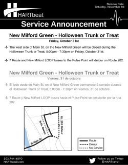

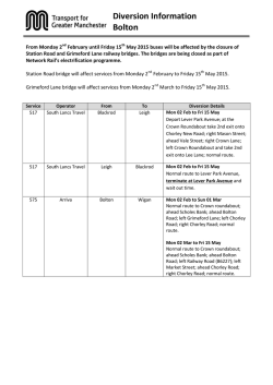
© Copyright 2026