
Roads approved for Modular B-Triples operating at General Mass
Modular B-Triple approved
roads
Roads approved for Modular B-Triples operating at
General Mass Limits (GML) and Concessional Mass
Limits (CML).
Note: This document does not apply to 36.5m B-Triples.
≤ 35.0 metres Total Combination Length
The following listed roads are approved for use by Modular B-triples operating up to 35.0m at
GML/CML subject to the vehicle and operator meeting the requirements of the National Class 2
Heavy Vehicle Road Train Authorisation (Notice) 2014.
When operating a Modular B-Triple at CML the operator must meet the conditions listed above
and must hold National Heavy Vehicle Accreditation Scheme (NHVAS) mass management
accreditation for the vehicle
State Roads
WESTERN REGION
Type
Road
No
35MB3
7
35MB3
7
35MB3
7
35MB3
7
35MB3
7
35MB3
8
Road
Name
Starting Point
Finishing Point
Mitchell
Highway
Mitchell
Highway
Mitchell
Highway
McNamaras Lane,
Narromine
MR7508 Culling
Road, Narromine
Northern end of
North Bourke
Bridge
NSW/ Qld Border at
Barringun
McNamaras Lane,
Narromine
NSW Qld Border at
Barringun
Mitchell
Highway
Mitchell
Highway
Barrier
Highway
Tantitha Road,
Narromine
Thompson Street,
Dubbo
Broken Hill City
Boundary, approx
6.4km east of
Phillips Street
MR89 Dandaloo
Road, Narromine
Tantitha Road,
Narromine
Broken Hill City
Boundary, approx
2m west of
MR7507 Creedon
Street
Access Condition(s)
Note - no parking of
trailers or dollies along
roadside except in
designated areas.
Roads & Maritime Services
PO Box 94 Glen Innes NSW 2370
T 1300 364 847 | E [email protected]
www.rms.nsw.gov.au
Page: 1/59
Roads approved for Modular B-Triples operating at
General Mass Limits (GML) and Concessional Mass
Limits (CML).
Type
Road
No
Road
Name
Starting Point
Finishing Point
Broken Hill town
Boundary, approx
2km west of
MR7507 Creedon
Street
HW7 Mitchell
Highway
NSW/SA Border at
Cockburn
35MB3
8
Barrier
Highway
35MB3
8
Barrier
Highway
35MB3
11
35MB3
12
Oxley
Highway
Gwydir
Highway
35MB3
12
35MB3
12
35MB3
12
35MB3
12
35MB3
18
35MB3
21
35MB3
22
Silver City
Highway
35MB3
22
Silver City
Highway
35MB3
22
Silver City
Highway
35MB3
22
Silver City
Highway
Gwydir
Highway
(Balo
Street)
Gwydir
Highway
(Boggabilla
Road)
Gwydir
Highway
(Coolibah
Road)
Gwydir
Highway
(Gwydir
Street)
Castlereag
h Highway
Cobb
Highway
HW7 Mitchell
Highway, Nevertire
HW18 Castlereagh
Highway, north of
Walgett
HW12 Gwydir
Highway (Gwydir
Street)
HW12 Gwydir
Highway (Balo
Street), Moree
Access Condition(s)
Broken Hill town
Boundary, approx
6.4km east of
Phillips Street
HW17 Newell
Highway, Gilgandra
HW12 Gwydir
Highway (Coolibah
Road), Moree
HW12 Gwydir
Highway
(Boggabilla Road),
Moree
HW17 Newell
Highway, Moree
HW12 Gwydir
Highway
(Greenbah Road)
HW12 Gwydir
Highway (Gwydir
Street)
HW12 Gwydir
Highway (Coolibah
Road)
HW12 Gwydir
Highway (Balo
Street), Moree
HW17 Newell
Highway, Gilgandra
HW8 Barrier
Highway, 19km
east of Wilcannia
Broken Hill City
Boundary, approx
550m south of
MR7507 Kanandah
Road
Broken Hill town
Boundary, approx
4.7km north of
Range Road
HW8 Barrier
Highway (Iodide
Street), Broken Hill
City
Unincorporated
Area Wentworth
Council Boundary
NSW / Qld Border
near Hebel Gate
Central Darling
Carrathool Shire
Boundary
HW8 Barrier
Highway, Broken
Hill City
NSW / Qld Border
at Warri Gate
Broken Hill City
Boundary, approx
4.7km north of
Range Road
Broken Hill town
Boundary, approx
550m south of
Kanandah Road
Roads & Maritime Services
PO Box 94 Glen Innes NSW 2370
T 1300 364 847 | E [email protected]
www.rms.nsw.gov.au
Page: 2/59
Roads approved for Modular B-Triples operating at
General Mass Limits (GML) and Concessional Mass
Limits (CML).
Type
Road
No
35MB3
28
35MB3
29
35MB3
29
35MB3
61
35MB3
61
35MB3
61
35MB3
70
35MB3
129
35MB3
410
35MB3
421
35MB3
421
Road
Name
Starting Point
Finishing Point
Carnarvon
Highway
(Garah
Mungindi
Road)
Kamilaroi
Highway
HW12 Gwydir
Highway
(Boggabilla Road),
Moree
NSW/ Qld Border at
Mungindi
HW17 Newell
Highway, Narrabri
Kamilaroi
Highway
Hartigan
Avenue
Parkes
Condobolin
Road
HW18 Castlereagh
Highway, Walgett
Brolgan Road,
Parkes
MR61 Westlime
Road, Parkes
Westlime
Road
Coolabah
Brewarrina
Road
Coonamble
Quambone
Road
Kidman
Way
Cobar
Bourke
Road
Cobar
Bourke
Road
Blaxland Street,
Parkes
HW7 Mitchell
Highway, Coolabah
HW18 Castlereagh
Highway,
Coonamble
Carrathool Cobar
Shire Boundary
Cobar Bourke Shire
Boundary
HW178
Castlereagh
Highway, Walgett
HW7 Mitchell
Highway, Bourke
Blaxland Street,
Parkes
MR57 West
Wyalong
Condobolin Road,
Condobolin
MR61 Condobolin
Road, Parkes
HW29 Kamilaroi
Highway,
Brewarrina
MR202 Warren
Carinda Road,
Quambone
HW8 Barrier
Highway, Cobar
HW7 Mitchell
Highway, Bourke
HW8 Barrier
Highway, Cobar
Cobar Bourke Shire
Boundary
Access Condition(s)
SOUTH WEST REGION
Type
Road
No
35MB3
6
35MB3
14
35MB3
20
35MB3
514
Road
Name
Starting Point
Finishing Point
Mid
Western
Highway
Sturt
Highway
HW21 Cobb
Highway, Hay
HW17 Newell
Highway, West
Wyalong
NSW / Vic Border,
Mildura
Riverina
Highway
Cobb
Highway
HW17 Newell
Highway,
Narrandera
(Eastern Junction)
HW21 Cobb
Highway, Deniliquin
Nicholas Drive,
Moama NSW
/ Victorian Border.
Access Condition(s)
HW17 Newell
Highway, Finley
Central Darling /
Carrathool
Shire Boundary
Roads & Maritime Services
PO Box 94 Glen Innes NSW 2370
T 1300 364 847 | E [email protected]
www.rms.nsw.gov.au
Page: 3/59
Roads approved for Modular B-Triples operating at
General Mass Limits (GML) and Concessional Mass
Limits (CML).
Type
Road
No
Road
Name
Starting Point
Finishing Point
Wentworth
Unincorporated
Area Boundary
Murrami Road,
Murrami
MR254 Whitton
Stock Route Road,
Yenda
Canal Street,
Leeton
35MB3
22
Silver City
Highway
HW14 Sturt
Highway, Buronga
35MB3
80
35MB3
80
Irrigation
Way
Irrigation
Way
Canal Street,
Leeton
Murrami Road,
Murrami
35MB3
80
Irrigation
Way
(Wamoon
Avenue)
35MB3
80
35MB3
84
Kidman
Way
Burley
Griffin Way
35MB3
84
35MB3
321
35MB3
410
35MB3
694
Entrance to Rice
Distribution Centre
on Wamoon
Avenue, 70m west
of Acacia Avenue
Kookora Street,
Griffith
Moombooldool
Sandy Creek Road,
Moombooldool
Whitton Stock
Route Road, Yenda
HW17 Newell
Highway, north of
Jerilderie
MR80 Oxley
Avenue, Hillston
MR467 Stoney
Crossing Road
(Swan Hill Kyalite
Road), Kyalite
Burley
Griffin Way
Kidman
Way
Kidman
Way
Yanga Way
Access Condition(s)
MR501 Lachlan
Valley Way, Hillston
MR254 Yenda
Leeton Road,
Yenda
Debortolli Road,
Bilbul
Willandra Avenue,
Griffith
Carrathool Cobar
Shire Boundary
HW14 Sturt
Highway, Balranald
Roads & Maritime Services
PO Box 94 Glen Innes NSW 2370
T 1300 364 847 | E [email protected]
www.rms.nsw.gov.au
Page: 4/59
Roads approved for Modular B-Triples operating at
General Mass Limits (GML) and Concessional Mass
Limits (CML).
Regional and Local Roads
BALRANALD SHIRE COUNCIL AREA
Access to Regional and Local roads listed below or west of a line joining the intersection of Cobb Highway
and Balranald Road in Ivanhoe with the centre of the Darling River Bridge at Wentworth.
Type
Road
Road
Starting Point
Finishing Point
Access Condition(s)
No
Name
35MB3
67
Balranald
Ivanhoe
Road
HW14 Stuart
Highway
35MB3
514
Oxley Road
(Hay
Penarie
Road)
Abbotts
Tank Road
Ballandella
Street
Bank Street
Benanee
Road
Church
Street
Clare Oxley
Road
Court
Street
Duryea
Street
Balranald / Hay
Shire Boundary
Balranald Central
Darling Shire
Boundary, approx
35km south of
Ivanhoe
MR67 Balranald /
Ivanhoe Road
Euston Prungle
Road
Moa Street
HW14 Sturt
Highway
Mayall Street
Church Street
HW14 Sturt
Highway
MR67 McCabe
Street
MR514 Oxley Road
Island Road
Euston Prungle
Road
Bank Street
HW14 Sturt
Highway
35MB3
Euston
Prungle
Road
Island
Road
Kyalite
Road
Mayall
Street
McCabe
Street
Meilman
Road
Moa Street
35MB3
Moa Street
35MB3
Murray
Valley Way
35MB3
35MB3
35MB3
35MB3
35MB3
35MB3
35MB3
35MB3
35MB3
35MB3
35MB3
35MB3
35MB3
35MB3
HW14 Sturt
Highway
HW14 Sturt
Highway
Bank Street
Note - check with council
for road closures.
Note - check with council
for road closures.
Nandum Corrong
Road
Mayall Street
Saleyards at end of
Duryea Street,
approx 1.1km from
HW14 Sturt
Highway
Prungle Mail Road
MR694 Yanga Way
MR67 McCabe
Street
Pearsons Road
Court Street
Ballandella Street
HW14 Sturt
Highway
HW14 Sturt
Highway
HW14 Sturt
Highway
HW14 Sturt
Highway
HW14 Sturt
Highway
MR67 Balranald
Ivanhoe Road
Meilman Station
Entrance
Ballandella Street
Note - check with council
for road closures.
Note - check with council
for road closures.
MR67 Balranald
Ivanhoe Road
NSW Victorian
Border
Roads & Maritime Services
PO Box 94 Glen Innes NSW 2370
T 1300 364 847 | E [email protected]
www.rms.nsw.gov.au
Page: 5/59
Roads approved for Modular B-Triples operating at
General Mass Limits (GML) and Concessional Mass
Limits (CML).
Type
Road
No
Road
Name
Starting Point
Finishing Point
35MB3
Pearsons
Road
Kyalite Road
35MB3
Prungle
Mail Road
Tapalin
Main Road
HW14 Sturt
Highway
HW14 Sturt
Highway
Tillara
Road
We Street
HW14 Sturt
Highway
HW14 Sturt
Highway
Windomal Road
Pearsons Entrance,
600m from Kyalite
Road
Euston Prungle
Road
Balranald/
Wentworth Shire
Boundary
Tillara Station
Entrance
Ballandella Street
35MB3
35MB3
35MB3
35MB3
Weimby
Benongal
Road
Windomal
Road
35MB3
HW14 Sturt
Highway
Access Condition(s)
Note - check with council
for road closures.
Note - check with council
for road closures.
Note - check with council
for road closures.
Weimby Kyalite
Road
Note - check with council
for road closures.
Weimby Kyalite
Road
Note - check with council
for road closures.
BERRIGAN SHIRE COUNCIL AREA
Type
Road
Name
Starting Point
Finishing Point
35MB3
Barnes
Road
South Coree Road
35MB3
35MB3
Dales Road
Edward
Street
Hamilton
Street
Logie Brae
Road
Lower
River Road
Tongs Road
Dales Road
Conargo Shire
Boundary, Logie
Brae Road
Edward Street
Finley Truck Wash
35MB3
Silo Road
Tuppal Road
35MB3
South
Coree
Road
Townsend
Street
Tuppal
Road
HW20 Riverina
Highway
35MB3
35MB3
35MB3
35MB3
35MB3
Road
No
HW20 Riverina
Highway
Barnes Road
Tongs Road
Tuppal Road
Berrigan Conargo
Shire Boundary,
approx 17km from
Tuppal Road
HW17 Newell
Highway
Berrigan Jerilderie
Shire Boundary at
Duncans Road
Hamilton Street
HW17 Newell
Highway
HW17 Newell
Highway
Access Condition(s)
Duncans Road
Speed limit 70km/hr. No
access May to October
inclusive.
Conargo Berrigan
Shire Boundary, at
Tuppal Creek
Bridge
BLAND SHIRE COUNCIL AREA
Roads & Maritime Services
PO Box 94 Glen Innes NSW 2370
T 1300 364 847 | E [email protected]
www.rms.nsw.gov.au
Page: 6/59
Roads approved for Modular B-Triples operating at
General Mass Limits (GML) and Concessional Mass
Limits (CML).
Type
Road
No
Road Name
Starting Point
Finishing Point
West
Wyalong
Condobolin
Road
Girral Lake
Cargelligo
Road
HW6 Mid Western
Highway
Bland Lachlan
Shire Boundary at
Barrons West Road
MR57 West
Wyalong
Condobolin Road)
Ariah Park
Road
Bashams
Lane
Tallimba Road
Bland Lachlan
Shire Boundary at
Weja Ugalong
Road
Meaghers Lane
Gunn Road
Timothys Lane
35MB3
Beatties
Lane
Kolkilbertoo Road
Overs Lane
35MB3
Begargo
Road
35MB3
Begargo
Road
Bland Lachlan
Shire Boundary,
approx 2.3km west
of Mercers Lane
MR371 Rankins
Springs Road
35MB3
Bimbeen
Road
Bland Lachlan
Shire Boundary,
approx 1km north
of Mercers Lane
Bland Lachlan
Shire Boundary,
approx 2.3km west
of Mercers Lane
Koops Lane
35MB3
Blow Clear
Road
Bonehams
Lane
Bootoowa
Road
35MB3
57
35MB3
231
35MB3
35MB3
35MB3
35MB3
MR57 West
Wyalong
Condobolin Road
Wamboyne Road
Speed limit 80km/hr.
Speed limit 80km/hr. Note
- check with council for
road closures.
Speed limit 80km/hr. Note
- check with council for
road closures.
Speed limit 80km/hr. Note
- check with council for
road closures.
No access March to
October inclusive.
Bonehams Lane
Speed limit 80km/hr. Note
- check with council for
road closures.
Speed limit 80km/hr.
Blow Clear Road
Cowal Gold Access
Speed limit 80km/hr.
MR371 Rankins
Springs Lake
Cargelligo Road
Kikoira Road
Morris Lane
Speed limit 80km/hr. Note
- check with council for
road closures.
Speed limit 80km/hr. Note
- check with council for
road closures.
Speed limit 80km/hr. Note
- check with council for
road closures.
Speed limit 80km/hr.
35MB3
Boreamble
Road
35MB3
Brennans
Tank Road
Halls Lane
35MB3
Brolga Road
Thulloo Road
35MB3
Browns Lane
HW6 Mid Western
Highway
HW6 Mid Western
Highway
35MB3
35MB3
Bulga Street
Buralyang
Road
Bygoo Road
Warrego Street
Bygoo Road
Hill Street
Sandy Creek Road
Kikoira Street,
Tallimba
Bland Coolamon
Shire Boundary,
Stewarts Lane
35MB3
Access Condition(s)
Bland Lachlan
Shire Boundary at
Tuggerabach Road
Bygoo Road
Merrengreen Road
Speed limit 80km/hr. Note
- check with council for
road closures.
Speed limit 80km/hr.
Speed limit 80km/hr.
Roads & Maritime Services
PO Box 94 Glen Innes NSW 2370
T 1300 364 847 | E [email protected]
www.rms.nsw.gov.au
Page: 7/59
Roads approved for Modular B-Triples operating at
General Mass Limits (GML) and Concessional Mass
Limits (CML).
Type
Road Name
Starting Point
Finishing Point
Access Condition(s)
35MB3
Calleen Lane
35MB3
Chanters
Lane
MR57 West
Wyalong
Condobolin Road
HW6 Mid Western
Highway
MR57 West
Wyalong
Condobolin Road
Mud Hut Road East
35MB3
Clear Ridge
Road
HW17 Newell
Highway
Blow Clear Road
35MB3
Clements
Lane
HW6 Mid Western
Highway
Tallimba Road
35MB3
Clowery
Tank Road
Dundas Road
Mud Hut Road
West
35MB3
Collins Lane
MR57 West
Wyalong
Condobolin Road
35MB3
Crown Camp
Road
MR231 Girral Lake
Cargelligo Road
35MB3
Dalgleish
Lane
Bygoo Road
Pace Farm Access,
approx 900m from
MR57 West
Wyalong
Condobolin Road
Bland Lachlan
Shire Boundary,
approx 2km south
of Swansons Road
Gunn Road
Speed limit 80km/hr. Note
- check with council for
road closures.
Speed limit 80km/hr. Note
- check with council for
road closures.
Speed limit 80km/hr. Note
- check with council for
road closures.
Speed limit 80km/hr. Note
- check with council for
road closures.
Speed limit 80km/hr. Note
- check with council for
road closures.
Speed limit 80km/hr.
35MB3
Danahers
Lane
Johns Road
South Yalgogrin
Road
35MB3
Dundas
Road
Dunlops
Lane
HW6 Mid Western
Highway
Brennans Tank
Road
Bradburys Lane
35MB3
Euratha
Road
HW6 Mid Western
Highway
35MB3
Fishers Lane
Kolkilbertoo Road
Carrathool Bland
Shire Boundary,
approx 2km south
of Martens Lane
Sandy Creek Road
35MB3
Flaggs Lane
Gunn Road
Danahers Lane
35MB3
Fullers Lane
MR231 Girral Lake
Cargelligo Road
Merrengreen Road
35MB3
Genista
Road
Kolkilbertoo Road
Sandy Creek Road
35MB3
Road
No
Russells Lane
Speed limit 80km/hr.
Speed limit 80km/hr. Note
- check with council for
road closures.
Speed limit 80km/hr. Note
- check with council for
road closures.
Speed limit 80km/hr.
Speed limit 80km/hr. Note
- check with council for
road closures.
Speed limit 80km/hr. Note
- check with council for
road closures.
Speed limit 80km/hr. Note
- check with council for
road closures.
Speed limit 80km/hr. Note
- check with council for
road closures.
Speed limit 80km/hr. Note
- check with council for
road closures.
Speed limit 80km/hr. Note
- check with council for
road closures.
Roads & Maritime Services
PO Box 94 Glen Innes NSW 2370
T 1300 364 847 | E [email protected]
www.rms.nsw.gov.au
Page: 8/59
Roads approved for Modular B-Triples operating at
General Mass Limits (GML) and Concessional Mass
Limits (CML).
Type
Road
No
Road Name
Starting Point
Finishing Point
Access Condition(s)
35MB3
Girral Road
Wamboyne Road
35MB3
Griffiths Lane
Naradhan Road
MR57 West
Wyalong
Condobolin Road
Tuggerabach Road
35MB3
Gubbatta
Road
Naradhan Road
Tuggerabach Road
35MB3
Gunn Road
Manglesdorfs Road
Sandy Creek Road
35MB3
Halls Lane
Ariah Park Road
Brennans Tank
Road
35MB3
Hannan
Road
HW6 Mid Western
Highway
Mud Hut Road
West
35MB3
Hatelys Lane
Calleen Lane
35MB3
Hatelys Lane
AWB Access Road,
approx 900m from
MR57 West
Wyalong
Condobolin Road
MR57 West
Wyalong
Condobolin Road
Speed limit 80km/hr. Note
- check with council for
road closures.
Speed limit 80km/hr. Note
- check with council for
road closures.
Speed limit 80km/hr. Note
- check with council for
road closures.
Speed limit 80km/hr. Note
- check with council for
road closures.
Speed limit 80km/hr. Note
- check with council for
road closures.
Speed limit 80km/hr. Note
- check with council for
road closures.
Speed limit 80km/hr. Note
- check with council for
road closures.
35MB3
Heatons
Lane
Hannan Road
AWB Access Road,
approx 900m from
MR57 West
Wyalong
Condobolin Road
Kneales Lane
35MB3
Jansens
Lane
Kolkilbertoo Road
Euratha Road
35MB3
Johns Road
Gunn Road
Danahers Lane
35MB3
Kikoira Road
Dundas Road
35MB3
Kolkilbertoo
Road
MR231 Girral Lake
Cargelligo Road
Wilga Street,
Weethalle
35MB3
Langes Lane
Clements Lane
35MB3
Lewes Road
HW6 Mid Western
Highway
Bland Narrandera
Shire Boundary,
approx 1km west of
Genista Road
Pfeiffers Lane
Paynes Road
Speed limit 80km/hr.
Speed limit 80km/hr. Note
- check with council for
road closures.
Speed limit 80km/hr. Note
- check with council for
road closures.
Speed limit 80km/hr. Note
- check with council for
road closures.
Speed limit 80km/hr.
Speed limit 80km/hr.
Speed limit 80km/hr. Note
- check with council for
road closures.
Speed limit 80km/hr. Note
- check with council for
road closures.
Roads & Maritime Services
PO Box 94 Glen Innes NSW 2370
T 1300 364 847 | E [email protected]
www.rms.nsw.gov.au
Page: 9/59
Roads approved for Modular B-Triples operating at
General Mass Limits (GML) and Concessional Mass
Limits (CML).
Type
Road
No
Road Name
Starting Point
Finishing Point
Access Condition(s)
35MB3
Livingstone
Road
Wamboyne Road
Speed limit 80km/hr. Note
- check with council for
road closures.
35MB3
Mallons Lane
Mud Hut Road
West
Bland Lachlan
Shire Boundary,
approx 200m north
of Wamboyne Road
Rutledges Road
35MB3
Malones
Lane
Kolkilbertoo Road
Euratha Road
35MB3
Manglesdorfs
Lane
Bygoo Road
Gunn Road
35MB3
Martens
Lane
Kolkilbertoo Road
Euratha Road
35MB3
Meaghers
Lane
Ariah Park Road
Tallimba Road
35MB3
Mercers
Lane
Begargo Road
Tuggerabach Road
35MB3
Merrengreen
Road
MR231 Girral Lake
Cargelligo Road
Fullers Lane
35MB3
Minogues
Lane
HW6 Mid Western
Highway
Mulga Lane
35MB3
Monia Gap
Road
Warburtons Lane
35MB3
Morris Lane
MR371 Rankins
Springs Lake
Cargelligo Road
Monia Gap Road
35MB3
Mud Hut
Road East
Dundas Road
Thulloo Road
35MB3
Mud Hut
Road West
Dundas Road
Hannan Road
35MB3
Mulga Lane
Hatelys Lane
Cattles Lane
35MB3
Naradhan
Road
Budda Street
Dundas Road
35MB3
Narriah Road
HW6 Mid Western
Highway
Lewes Road
35MB3
Overs Lane
Kolkilbertoo Road
Beatties Lane
Bootoowa Road
Speed limit 80km/hr. Note
- check with council for
road closures.
Speed limit 80km/hr. Note
- check with council for
road closures.
Speed limit 80km/hr. Note
- check with council for
road closures.
Speed limit 80km/hr. Note
- check with council for
road closures.
Speed limit 80km/hr. Note
- check with council for
road closures.
Speed limit 80km/hr. Note
- check with council for
road closures.
Speed limit 80km/hr. Note
- check with council for
road closures.
Speed limit 80km/hr. Note
- check with council for
road closures.
Speed limit 80km/hr. Note
- check with council for
road closures.
Speed limit 80km/hr. Note
- check with council for
road closures.
Speed limit 80km/hr. Note
- check with council for
road closures.
Speed limit 80km/hr. Note
- check with council for
road closures.
Speed limit 80km/hr. Note
- check with council for
road closures.
Speed limit 80km/hr. Note
- check with council for
road closures.
Speed limit 80km/hr. Note
- check with council for
road closures.
Speed limit 80km/hr. Note
- check with council for
road closures.
Roads & Maritime Services
PO Box 94 Glen Innes NSW 2370
T 1300 364 847 | E [email protected]
www.rms.nsw.gov.au
Page: 10/59
Roads approved for Modular B-Triples operating at
General Mass Limits (GML) and Concessional Mass
Limits (CML).
Type
Road Name
Starting Point
Finishing Point
Access Condition(s)
35MB3
Oxley Road
HW6 Mid Western
Highway
Stuarts Lane
35MB3
Paynes Road
HW6 Mid Western
Highway
Bygoo Road
35MB3
Pfeiffers
Lane
HW6 Mid Western
Highway
Langes Lane
35MB3
Pine Road
Naradhan Road
Naradhan Grain
Silo
35MB3
Popes Lane
Bygoo Road
Dunlops Lane
35MB3
Ridleys Lane
Hatelys Lane
35MB3
Russells
Lane
MR57 West
Wyalong
Condobolin Road
Bygoo Road
35MB3
Russells
Lane
MR231 Girral Lake
Cargelligo Road
Deacons Lane
35MB3
Rutledges
Lane
Talleeban Road
Dundas Lane
35MB3
Sandy Creek
Road
Genista Road
Lewes Road
35MB3
Showground
Road
South
Yalgogrin
Road
Spencers
Lane
HW6 Mid Western
Highway
Sandy Creek Road
HW17 Newell
Highway
Gunn Road
Speed limit 80km/hr. Note
- check with council for
road closures.
Speed limit 80km/hr. Note
- check with council for
road closures.
Speed limit 80km/hr. Note
- check with council for
road closures.
Speed limit 80km/hr. Note
- check with council for
road closures.
Speed limit 80km/hr. Note
- check with council for
road closures.
Speed limit 80km/hr. Note
- check with council for
road closures.
Speed limit 80km/hr. Note
- check with council for
road closures.
Speed limit 80km/hr. Note
- check with council for
road closures.
Speed limit 80km/hr. Note
- check with council for
road closures.
Speed limit 80km/hr. Note
- check with council for
road closures.
Speed limit 80km/hr.
Yalgogrin Road
Manglesdorfs Lane
35MB3
Sullivans
Lane
Girral Road
Wamboyne Road
35MB3
Talleeban
Road
Kneales Lane
Mud Hut Road
West
35MB3
Talleeban
Road
Mud Hut Road
West
Naradhan Road
35MB3
Tallimba
Road
Tallimba
Road
Hiawatha Street,
Tallimba
HW17 Newell
Highway
Kikoira Street,
Tallimba
Hiawatha Street,
Tallimba
35MB3
35MB3
35MB3
Road
No
Dunlops Lane
Speed limit 80km/hr. Note
- check with council for
road closures.
Speed limit 80km/hr. Note
- check with council for
road closures.
Speed limit 80km/hr. Note
- check with council for
road closures.
Speed limit 80km/hr. Note
- check with council for
road closures.
Speed limit 80km/hr. Note
- check with council for
road closures.
Speed limit 80km/hr.
Speed limit 80km/hr.
Roads & Maritime Services
PO Box 94 Glen Innes NSW 2370
T 1300 364 847 | E [email protected]
www.rms.nsw.gov.au
Page: 11/59
Roads approved for Modular B-Triples operating at
General Mass Limits (GML) and Concessional Mass
Limits (CML).
Type
Road Name
Starting Point
Finishing Point
Access Condition(s)
35MB3
Thulloo Road
HW6 Mid Western
Highway
Kikoira Road
35MB3
Timothys
Lane
Bygoo Road
Buralyang Road
35MB3
Tuggerabach
Road
Blackers Lane
35MB3
Tuggerabach
Road
35MB3
Ungarie
Condobolin
Road
Bland Lachlan
Shire Boundary,
approx 1.4km west
of Bradburys Lane
Bland Lachlan
Shire Boundary,
approx 1.4km west
of Bradburys Lane
Crown Camp Road
Speed limit 80km/hr. Note
- check with council for
road closures.
Speed limit 80km/hr. Note
- check with council for
road closures.
Speed limit 80km/hr. Note
- check with council for
road closures.
35MB3
Wamboyne
Dip Road
Livingstone Road
35MB3
Wamboyne
Road
35MB3
Warburtons
Lane
35MB3
Warrego
Street
Weja Road
MR57 West
Wyalong
Condobolin Road
MR368 Rankins
Springs Hillston
Road
HW6 Mid Western
Highway
MR231 Girral Lake
Cargelligo Road
35MB3
Road
No
Weja Road
Speed limit 80km/hr. Note
- check with council for
road closures.
Bland Lachlan
Shire Boundary,
approx 600m north
of Webbs Lane
Bland Lachlan
Shire Boundary at
Buttenshaws Lane
Livingstone Road
Speed limit 80km/hr. Note
- check with council for
road closures.
Monia Gap Road
Speed limit 80km/hr. Note
- check with council for
road closures.
Speed limit 80km/hr. Note
- check with council for
road closures.
Speed limit 80km/hr.
Wilga Street
Kikoira Road
35MB3
Wilga Plains
Road
Crown Camp Road
Deacons Lane
35MB3
Winnunga
Road
MR231 Girral Lake
Cargelligo Road
Kikoira Road
35MB3
Yarran Street
Budda Street
35MB3
Younga
Plains Road
35MB3
Youngareen
Road
MR371 Rankin
Springs Lake
Cargelligo Road
MR57 West
Wyalong
Condobolin Road
HW6 Mid Western
Highway
Wamboyne Road
Kikoira Road
Speed limit 80km/hr. Note
- check with council for
road closures.
Speed limit 80km/hr. Note
- check with council for
road closures.
Speed limit 80km/hr. Note
- check with council for
road closures.
Speed limit 80km/hr. Note
- check with council for
road closures.
Speed limit 80km/hr. Note
- check with council for
road closures.
Speed limit 80km/hr. Note
- check with council for
road closures.
Roads & Maritime Services
PO Box 94 Glen Innes NSW 2370
T 1300 364 847 | E [email protected]
www.rms.nsw.gov.au
Page: 12/59
Roads approved for Modular B-Triples operating at
General Mass Limits (GML) and Concessional Mass
Limits (CML).
BOGAN SHIRE COUNCIL AREA
Access to all Regional and Local roads within the Bogan Shire Council area located north of HW8 Barrier
Highway and west of Colane Road and roads separately listed.
Type
Road
No
35MB3
57
35MB3
424
35MB3
461
35MB3
7514
35MB3
35MB3
35MB3
35MB3
35MB3
35MB3
35MB3
35MB3
35MB3
35MB3
35MB3
35MB3
35MB3
35MB3
35MB3
35MB3
Road Name
Starting Point
Finishing Point
Tullamore
Nyngan
Road
Stoney Hills
Mundadoo
Road
(Monkey
Bridge Road)
Cobar
Condobolin
Road
HW7 Mitchell
Highway
Lunaria Road,
Bogan Lachlan
Shire Boundary
Bogan Warren
Shire Boundary
Melrose
Muddal Road
(Cockies
Road)
Backhouses
Road
Benah Road
Billandry
Road
MR57 Tullamore
Nyngan Road
Bobadah
Road
Bobadah
Road
Booramugga
Road
Bourkes
Lane
Buckinguy
Road
Buddebadah
Road
Bogan Lachlan
Shire Boundary
Pangee Road
Budgery
Road
Cannonbar
Street
Canonba
Road
Cemetery
Road
Coffils Lane
Colane Road
Colbain
Road
MR70 Coolabah
Brewarrina Road
Lachlan Bogan
Shire Boundary
Kidstons Road
Canonba Road
Bobadah Road
HW7 Mitchell
Highway
Gilgai Road
Colane Road
Mulla Road
(Warren Bogan
Shire Boundary)
HW8 Barrier
Highway
Cemetery Road
Moonagee Road
Pangee Street
Gilgai Road
Canonba Road
Bobadah Road
Access Condition(s)
Bogan Cobar Shire
Boundary,
Nangerybone State
Forest
Lachlan Bogan
Shire Boundary
End of road, approx
3.5km
Colane Road
Landsdale Road,
Lachlan Bogan
Shire Boundary
Billandry Road
Bogan Lachlan
Shire Boundary
Elmore Road
Pangee Road
Bogan Warren
Shire Boundary
Dandaloo Road
End of road, approx
2.5km
150m west of
Cemetery Road
Bogan Warren
Shire Boundary
Cannonbar Street
Pangee Road
Bogan Warren
Shire Boundary
End of road, approx
4km
Roads & Maritime Services
PO Box 94 Glen Innes NSW 2370
T 1300 364 847 | E [email protected]
www.rms.nsw.gov.au
Page: 13/59
Roads approved for Modular B-Triples operating at
General Mass Limits (GML) and Concessional Mass
Limits (CML).
Type
35MB3
35MB3
35MB3
35MB3
35MB3
35MB3
Road
No
Road Name
Starting Point
Finishing Point
Cooneybar
Road
Cooney's
Road
Coxs Road
Cobar Bogan Shire
Boundary
HW8 Barrier
Highway
MR424 Stoney Hills
Mundadoo Road
(Monkey Bridge
Road)
Gilgai Road
HW7 Mitchell
Highway
End of road, approx
9km
End of road, approx
8.5km
Currans
Road
Dandaloo
Road
Days Road
MR57 Tullamore
Nyngan Road
HW7 Mitchell
Highway
Flashman Avenue
35MB3
Derrybong
Street
35MB3
Canbellego Road
35MB3
Dickson's
Road
Doneys
Road
Drummeys
Road
East Nyngan
Road
Elmore Road
Eulo Glen
Road
Fergusons
Road
Flashman
Avenue
Ford Street
35MB3
Fords Road
35MB3
35MB3
Gibson Road
Gilgai Road
35MB3
Glengariff
Road
MR461 Cobar
Condobolin Road
Mulla Road
HW8 Barrier
Highway
Peisley Road
35MB3
Gongolgon
Road
35MB3
Healy's Road
35MB3
Honeybugle
Road
35MB3
35MB3
35MB3
35MB3
35MB3
35MB3
35MB3
MR70 Coolabah
Brewarrina Road
Pangee Road
Boundary Road
(Levee Bank)
Booramugga Road
Buddabadah Road
Booramugga Road
Derrybong Street
Nyngan Street
MR424 Stoney Hills
Mundadoo Road
(Monkey Bridge
Road)
MR228 Hermidale
Nymagee Road
Pangee Road
Access Condition(s)
MR228 Hermidale
Nymagee Road
Warren Bogan
Shire Boundary
End of road, approx
5km
HW7 Mitchell
Highway (Nymagee
Street)
End of road, approx
6km
End of road, Grid
approx 17km
End of road, approx
8km
End of road, approx
1.4km
Cooneybar Road
End of road, approx
7.5km
End of road, approx
6.8km
Hoskins Street
HW7 Mitchell
Highway (Pangee
Street)
End of road, approx
12km
Buddebadah Road
MR228 Hermidale
Nymagee Road
RR7514 Melrose
Muddal Road
(Cockies Road)
Murrawombie Road
End of road, approx
5.3km
Peisley Road
Roads & Maritime Services
PO Box 94 Glen Innes NSW 2370
T 1300 364 847 | E [email protected]
www.rms.nsw.gov.au
Page: 14/59
Roads approved for Modular B-Triples operating at
General Mass Limits (GML) and Concessional Mass
Limits (CML).
Type
Road Name
Starting Point
Finishing Point
Flashman Avenue
35MB3
Hoskins
Street
Jefferys
Road
John Butler
Road
Johnsons
Road
Jumps Road
35MB3
Kallara Road
35MB3
Kamanganon
Road
Kellys Road
Kidstons
Road
Laroo Road
Larsen's
Road
Logans Road
Boundary Road
(Levee Bank)
End of road, approx
5.5km
End of road, approx
1.5km
End of road, approx
5km
Balgillo Gate,
approx 10km
HW8 Barrier
Highway
End of road, approx
14.5km
Glengariff Road
Backhouses Road
35MB3
35MB3
35MB3
35MB3
35MB3
35MB3
35MB3
35MB3
35MB3
35MB3
Road
No
MR228 Hermidale
Nymagee Road
HW7 Mitchell
Highway
Booramugga Road
HW7 Mitchell
Highway
MR228 Hermidale
Nymagee Road
Glengariff Road
Peisley Road
MR57 Tullamore
Nyngan Road
Cooney's Road
New Bogan Road
Warrah Road
Merryanbone
Road
Moonagee
Road
Canonba Road
35MB3
Moonagee
Street
35MB3
Mulla Road
35MB3
Murrawombi
e Road
Neeroc Road
HW7 Mitchell
Highway (Nymagee
Street)
HW7 Mitchell
Highway
HW7 Mitchell
Highway
HW8 Barrier
Highway
Okeh Road
35MB3
35MB3
35MB3
35MB3
New Bogan
Road
Nyngan
Street
35MB3
Oatley Street
35MB3
Okeh Road
35MB3
Old Warren
Road
O'Neills
Road
Pangee
Road
35MB3
35MB3
Colane Road,
Nyngan
HW7 Mitchell
Highway (Pangee
Street)
MR57 Tullamore
Nyngan Road
(Tottenham Road)
Murrawombie Road
Access Condition(s)
Whiterock Road
Windella Gate,
approx 4km
End of road, approx
4km
Bogan Warren
Shire Boundary
End of road, approx
32km north of
Nyngan
Colane Street
Gibson Road
Colane Road
End of road, approx
4.5km
Larsen's Road
Ford Street
Hoskins Street
Hospital Road
Okeh Gate, approx
20km
Merryanbone Road
HW8 Barrier
Highway
MR57 Tullamore
Nyngan Road
Wilga Gate, approx
8.3km
MR461 Cobar
Condobolin Road
Roads & Maritime Services
PO Box 94 Glen Innes NSW 2370
T 1300 364 847 | E [email protected]
www.rms.nsw.gov.au
Page: 15/59
Roads approved for Modular B-Triples operating at
General Mass Limits (GML) and Concessional Mass
Limits (CML).
Type
Road Name
Starting Point
Finishing Point
HW7 Mitchell
Highway
Hoskins Street
Terangion Street
Pangee Road
35MB3
Pangee
Street
Pangee
Street,
Nyngan
Parkers
Road
Paynes Road
35MB3
Peisley Road
35MB3
Peisley Road
End of road, approx
5km
End of road, approx
11.5km
RR7514 Melrose
Muddal Road
(Cockies Road)
MR57 Tullamore
Nyngan Road
35MB3
Pepper Lane
35MB3
Plummers
Road
35MB3
Priors Road
35MB3
Rutherglen
Road
Sarona
Downs Road
Shannonvale
Road
Simpsons
Road
Singletons
Road
Ski Lane
35MB3
35MB3
35MB3
35MB3
35MB3
35MB3
35MB3
35MB3
35MB3
35MB3
35MB3
35MB3
Road
No
Temples
Lane
Tikkara Road
Trethowans
Road
Tubba Villa
Road
35MB3
Warrah Road
35MB3
Warrego
Road
Wera Road
35MB3
HW7 Mitchell
Highway
MR228 Nymagee
Hermidale Road
RR7514 Melrose
Muddal Road
(Cockies Road)
Colane Road
RR7514 Melrose
Muddal Road
(Cockies Road)
HW7 Mitchell
Highway
HW8 Barrier
Highway
MR228 Hermidale
Nymagee Road
Plummers Road
MR57 Tullamore
Nyngan Road
HW7 Mitchell
Highway
Temples Lane
HW8 Barrier
Highway
HW8 Barrier
Highway
MR228 Hermidale
Nymagee Road
MR424 Stoney Hills
Mundadoo Road
(Monkey Bridge
Road)
RR7514 Melrose
Muddal Road
(Cockies Road)
Booramugga Road
MR57 Tullamore
Nyngan Road
Access Condition(s)
Cemetery Road
End of road, approx
2.1km
End of road, approx
28km
End of road, approx
5km
End of road, approx
3.3km
Entire length,
approx 7.5km
End of road, approx
8km
End of road, approx
4.5km
End of road, approx
3km
End of road, approx
600m
End of road, approx
6.3km
End of road, approx
1km
End of road, approx
5km
End of road, approx
7km
Lachlan Bogan
Shire Boundary
(Logans Road)
End of road, approx
4km
End of road, approx
5km
Roads & Maritime Services
PO Box 94 Glen Innes NSW 2370
T 1300 364 847 | E [email protected]
www.rms.nsw.gov.au
Page: 16/59
Roads approved for Modular B-Triples operating at
General Mass Limits (GML) and Concessional Mass
Limits (CML).
Type
Road
No
35MB3
35MB3
35MB3
35MB3
35MB3
35MB3
Road Name
Starting Point
Finishing Point
West Bogan
Road
Westlyn
Road
Whiterock
Road
Wilgaree
Road
Wyes Road
HW7 Mitchell
Highway
HW8 Barrier
Highway
HW8 Barrier
Highway
HW7 Mitchell
Highway
MR57 Tullamore
Nyngan Road
HW8 Barrier
Highway
Grid end of road,
approx 14.5km
End of road, approx
11km
End of road, approx
25km
End of road, approx
6.5km
End of road, approx
6.5km
Booramugga Road
Yarrandale
Road
Access Condition(s)
BOURKE SHIRE COUNCIL AREA
Access to all Regional and Local roads within Bourke Shire Council area.
Type
Road
Road
Starting Point
Finishing Point
No
Name
Access Condition(s)
BREWARRINA SHIRE COUNCIL AREA
Access to all Regional and Local roads within Brewarrina Shire Council area.
Type
Road
Road
Starting Point
Finishing Point
No
Name
Access Condition(s)
BROKEN HILL SHIRE COUNCIL AREA
Type
Road
No
Road
Name
Starting Point
Finishing Point
Broken Hill City
Boundary, approx
8km from HW8
Barrier Highway
HW8 Barrier
Highway (Rakow
Street)
Broken Hill City
Boundary, approx
2.4km from Brown
Street
HW8 Barrier
Highway (Rakow
Street)
MR7507 Ryan
Street
MR7507 Creedon
Street
HW8 Barrier
Highway
35MB3
66
Menindee
Road
HW8 Barrier
Highway
35MB3
81
Brookfield
Avenue
Brown Street
35MB3
81
Horsington
Drive
Brown Street
35MB3
7507
Creedon
Street
MR7507 Ryan
Street
35MB3
7507
35MB3
7507
Kanandah
Road
Ryan Street
HW22 Silver City
Highway
MR7507 Kanandah
Road
Wolfram Street
35MB3
Bagot
Street
Access Condition(s)
Roads & Maritime Services
PO Box 94 Glen Innes NSW 2370
T 1300 364 847 | E [email protected]
www.rms.nsw.gov.au
Page: 17/59
Roads approved for Modular B-Triples operating at
General Mass Limits (GML) and Concessional Mass
Limits (CML).
Type
35MB3
35MB3
35MB3
35MB3
35MB3
35MB3
35MB3
35MB3
Road
No
Road
Name
Starting Point
Finishing Point
Brown
Street
Comstock
Street
Creedon
Street
Crystal
Street
Oxide Street
Kaolin Street
Patton Street
Eyre Street
MR7507 Ryan
Street
HW22 Silver City
Highway (Iodide
Street)
Iodide Street
Gaffney Street
Comstock Street
McCulloch Street
Holten Drive
Murton Street
Creedon Street
HW22 Silver City
Highway (South
Street)
Newton Lane
Cummins
Street
Eyre Street
Fisher
Street
Gaffney
Street
35MB3
Harris
Street
35MB3
Holten
Drive
Iodide
Street
Kanandah
Place
Kaolin
Street
35MB3
35MB3
35MB3
35MB3
Kaolin
Street
35MB3
McCulloch
Street
Morgan
Street
Murton
Street
35MB3
35MB3
35MB3
35MB3
Newton
Lane
Nicholls
Street
HW8 Barrier
Highway (Rakow
Street)
Eyre Street
Schlapp Street
MR7507 Kanandah
Road
HW8 Barrier
Highway (William
Street)
Mica Lane
Cummins Street
Kaolin Street
HW22 Silver City
Highway (William
Street)
Harris Street
Newton Lane
35MB3
Nine Mile
Road
Schlapp Street
35MB3
O'Farrell
Street
Morgan Street
Access Condition(s)
MR66 Menindee
Road
McCulloch Street
MR66 Menindee
Road
Cummins Street
Industrial Sites (No
Through Road)
Schlapp Street
.
HW8 Barrier
Highway (William
Street)
Fisher Street
No access between
sunset and sunrise.
MR81 Brookfield
Avenue
Fisher Street
Nicholls Street
HW8 Barrier
Highway (Rakow
Street)
Broken Hill City
Boundary, approx
6.7km from
Schlapp Street
HW8 Barrier
Highway (William
Street)
Roads & Maritime Services
PO Box 94 Glen Innes NSW 2370
T 1300 364 847 | E [email protected]
www.rms.nsw.gov.au
Page: 18/59
Roads approved for Modular B-Triples operating at
General Mass Limits (GML) and Concessional Mass
Limits (CML).
Type
Road
No
35MB3
35MB3
35MB3
Road
Name
Starting Point
Finishing Point
Oxide
Street
Patton
Street
Brown Street
Schlapp Street
HW22 Silver City
Highway (Bonanza
Street)
Pinnacles Road
Comstock Street
MR7507 Kanandah
Road
Broken Hill town
Boundary, approx
2.6km from
MR7507 Kanandah
Road
Comstock Street
Pinnacles
Place
Pinnacles
Road
35MB3
35MB3
Piper Street
35MB3
Schlapp
Street
HW22 Silver City
Highway (Bonanza
Street)
Oxide Street
Access Condition(s)
Entire length
Brazil Street
CARRATHOOL SHIRE COUNCIL AREA
Type
Road
No
Road
Name
Starting Point
Finishing Point
Access Condition(s)
Truck Parking Area,
approx 300m north
of MR410 Kidman
Way
HW6 Mid Western
Highway
Griffith Carrathool
Shire Boundary
HW21 Cobb
Highway, Mossgiel
Note - check with council
for road closures.
HW6 Mid Western
Highway
MR80 Kidman Way
HW6 Mid Western
Highway
Bland Lachlan
Shire Boundary
MR410 Willanthry
Bridge the Priory
Road
Carrathool Lachlan
Shire Boundary,
approx 8.5km west
of Mount Daylight
Road
MR244 Carrathool
Road
Cahills Road
35MB3
80
Hillston to
Mossgiel
Road
35MB3
244
35MB3
321
35MB3
368
35MB3
371
35MB3
501
Carrathool
Road
Rankins
Springs
Road
Rankins
Springs
Hillston
Road
Rankins
Springs to
Lake
Cargelligo
Road
Lachlan
Valley Way
35MB3
7606
35MB3
35MB3
Tabbita
Lane
Back
Hillston
Road
Boundary
Street
MR80 Kidman Way
Melbergen Road
Molesworth Street
MR7606 Tabbita
Lane
Eight Mile Tank
Road
MR501 Lachlan
Valley Way
Note - check with council
for road closures.
Note - check with council
for road closures.
Note - check with council
for road closures.
Roads & Maritime Services
PO Box 94 Glen Innes NSW 2370
T 1300 364 847 | E [email protected]
www.rms.nsw.gov.au
Page: 19/59
Roads approved for Modular B-Triples operating at
General Mass Limits (GML) and Concessional Mass
Limits (CML).
Type
Road
Name
Starting Point
Finishing Point
Access Condition(s)
Bradys
Road
Cahills
Road
Carego
Lane
HW6 Mid Western
Highway
Wollarma Road
Wollarma Road
HW6 Mid Western
Highway
Cobram
Street
Collins
Street
Cowper
Street
Devon
Street
Erigolia
Road
HW6 Mid Western
Highway
MR368 Rankins
Springs Road
MR410 Kidman
Way, Hillston
Melbergen Street
Entrance to
Property "Bri Bri" a
Distance of approx
6 km
MR80 Kidman Way
Note - check with council
for road closures.
Note - check with council
for road closures.
Note - check with council
for road closures.
35MB3
Erigolia
Road
MR84 Burley Griffin
Way
35MB3
Farrer
Street
Lowan Street
35MB3
Federation
Road
Ilkadoon
Road
Jennings
Road
Lachlan
River Road
Lowan
Street
MR80 Kidman Way
Devon Street
HW6 Mid Western
Highway
Munros Street
MR7606 Tabbita
Lane
HW6 Mid Western
Highway
MR410 Kidman
Way
Farrer Street
35MB3
Melbergen
Road
Back Hillston Road
35MB3
Melbergen
Street
Merungle
Road
Milton
Road
MR368 Rankins
Springs Hillston
Road
MR80 Kidman Way
MR80 Hillston
Mossgiel Road
Lachlan River Road
11.6km west to
Brooklyn Entrance
Cowper Street
35MB3
35MB3
35MB3
35MB3
35MB3
35MB3
35MB3
35MB3
35MB3
35MB3
35MB3
35MB3
35MB3
35MB3
Road
No
Carrathool Shire
Boundary, approx
1.7km south of
Foys Road
MR80 Hillston
Mossgiel Road
Cobram Street
Back Hillston Road
Pattersons Road
Note - check with council
for road closures.
Milton Street
Federation Road
Intersection of
Erigolia Road and
the Bluff Road a
Distance of 12
Kilometres.
Binya Road,
Narrandera Shire
Boundary a
Distance of 5
Kilometres.
HW6 Mid Western
Highway
Devon Street
No access 8:00-9:30am
and 2:30-4:00pm on
school days.
Note - check with council
for road closures.
Note - check with council
for road closures.
No access 8:00-9:30am
and 2:30-4:00pm on
school days.
Note - check with council
for road closures.
Note - check with council
for road closures.
Note - check with council
for road closures.
Roads & Maritime Services
PO Box 94 Glen Innes NSW 2370
T 1300 364 847 | E [email protected]
www.rms.nsw.gov.au
Page: 20/59
Roads approved for Modular B-Triples operating at
General Mass Limits (GML) and Concessional Mass
Limits (CML).
Type
Road
No
Road
Name
Starting Point
Finishing Point
Access Condition(s)
35MB3
Mitchells
Road
MR410 Kidman
Way
Note - check with council
for road closures.
35MB3
Molesworth
Street
Munros
Street
Napier
Street
Regent Street
Property Entrance
approx 4.5km east
of MR410 Kidman
Way
Boundary Street
HW6 Mid Western
Highway
Cobram Street
Jennings Road
(2Nd Occurrence)
Bradys Road
Collins Street
Cowper Street
35MB3
Silos Road
35MB3
Smith Road
35MB3
Wallanthry
Road
MR501 Lachlan
Valley Way
MR80 Hillston
Mossgiel Road
MR368 Rankins
Springs Road
MR501 Lachlan
Valley Way
MR410 Kidman
Way
Molesworth Street
35MB3
Patterson
Street
Regent
Street
Roto Road
35MB3
Wollarma
Road
35MB3
35MB3
35MB3
35MB3
Bradys Road
Matakana Road
Intersection
MR410 Kidman
Way, Hillston
MR80 Kidman Way
Carrathool /
Lachlan Cobar
Shire Boundary,
approx 33km from
MR410 Kidman
Way
Cahills Road
No access 8:00-9:30am
and 2:30-4:00pm on
school days.
Note - check with council
for road closures.
Note - check with council
for road closures.
Note - check with council
for road closures.
Note - check with council
for road closures.
CENTRAL DARLING SHIRE COUNCIL AREA
Access to all Regional and Local roads within Central Darling Shire Council area.
Type
Road
Road
Starting Point
Finishing Point
Access Condition(s)
No
Name
COBAR SHIRE COUNCIL AREA
Access to all Regional and Local roads within Cobar Shire Council area except for:
(1) Regional and Local roads within Cobar town;
(2) Regional and Local roads within Euabalong West town;
(3) Regional and Local roads within Euabalong town;
unless separately listed.
Type
Road
Road Name
Starting Point
Finishing Point
Access Condition(s)
No
35MB3
407
35MB3
411
35MB3
423
Cobar Louth
Road
Euabalong
Mount Hope
Road
Lachlan
Valley Way
HW8 Barrier
Highway, Cobar
MR410 Kidman
Way, Mount Hope
Lachlan Cobar
Shire Boundary
Cobar Bourke Shire
Boundary
MR423 Lachlan
Valley Way,
Euabalong
MR411 Euabalong
Mount Hope Road
Roads & Maritime Services
PO Box 94 Glen Innes NSW 2370
T 1300 364 847 | E [email protected]
www.rms.nsw.gov.au
Page: 21/59
Roads approved for Modular B-Triples operating at
General Mass Limits (GML) and Concessional Mass
Limits (CML).
Type
Road
No
35MB3
7521
35MB3
7521
35MB3
7522
35MB3
35MB3
35MB3
35MB3
35MB3
35MB3
35MB3
35MB3
35MB3
35MB3
35MB3
35MB3
35MB3
35MB3
35MB3
Road Name
Starting Point
Finishing Point
Condobolin
Euabalong
Road
Uabba Street
Lachlan Cobar
Shire Boundary
MR411 Euabalong
Mount Hope Road
MR411 Euabalong
Mount Hope Road
Cobar
Ivanhoe
Road
HW8 Barrier
Highway, Cobar
Bathurst
Street
Becker
Street
Becker
Street
Blakey Street
Bourke
Street
Bourke
Street
Brickworks
Road
Campbell
Street
Cornish
Street
Dapville
Street
Dunstan
Street
Gibbes
Street
Government
Road
Hartmann
Street
Hercules
Street
HW8 Barrier
Highway
Bathurst Street
RR7521
Condobolin
Euabalong Road
Belarabon Barnato
Tank Road
(MR415) at
Belarabon
Becker Street
35MB3
Lavina Street
35MB3
35MB3
Lerida Street
Lewis Street
35MB3
Monaghan
Street
Murray
Street
Murray
Street
35MB3
35MB3
Monaghan Street
Murray Street
Bourke Street
Lewis Street
Becker Street
Dapville Street
Woodiwiss Street
HW8 Barrier
Highway
HW8 Barrier
Highway
Cornish Street
Old Bourke Road
Dunstan Street
Old Bourke Road
Approx 100m east
of Brickworks Road
Brickworks Road
Prince Street
Dunstan Street
HW8 Barrier
Highway
Campbell Street
Cornish Street
Old Bourke Road
Approx 100m east
of Gibbes Street
Government Street
Campbell Street
MR423 Lachlan
Valley Way, (Lake
Cargelligo
Euabalong Road)
Cornish Street
Woodiwiss Street
HW8 Barrier
Highway
Becker Street
HW8 Barrier
Highway
HW8 Barrier
Highway
Access Condition(s)
Government Street
MR411 Euabalong
Mount Hope Road
Approx 350m north
of Cornish Street
Airport Road
Blakey Street
HW8 Barrier
Highway
Becker Street
Woodiwiss Street
Roads & Maritime Services
PO Box 94 Glen Innes NSW 2370
T 1300 364 847 | E [email protected]
www.rms.nsw.gov.au
Page: 22/59
Roads approved for Modular B-Triples operating at
General Mass Limits (GML) and Concessional Mass
Limits (CML).
Type
Road
No
Road Name
Starting Point
Finishing Point
35MB3
Old Bourke
Road
HW8 Barrier
Highway
35MB3
35MB3
Prince Street
Railway
Parade
South
Woodiwiss
Street
Wrightville
Street
Murray Street
MR421 Kidman
Way
Entire length,
approx 650m north
of Railway Parade
Bourke Street
Old Bourke Road
35MB3
35MB3
Blakey Street
Lerida Street
Dapville Street
Cornish Street
Access Condition(s)
CONARGO SHIRE COUNCIL AREA
Type
Road
No
Road
Name
Starting Point
Finishing Point
Barratta Creek
Bridge, 26.4km
west of Pretty Pine
Conargo Jerilderie
Shire Boundary,
approx 9.6km east
of Coree Road
Conargo Murray
Shire Boundary, at
Tuppal Creek
Bridge
Steam Plains
Property Entrance,
approx 2km North
from Mabins Well
Road
Approx 4km north
of MR296 Barratta
Road
Normanswood
Entrance approx
1.6km north of
Mayrung Road
Moonee Swamp
Road
Conargo Jerilderie
Shire Boundary,
approx 1.6kms
west of Goolgumbla
Road
Property 819
Mayrung Road,
Lindifferon, approx
1.1km east of
Forest Creek Road
35MB3
296
Barratta
Road
HW21 Cobb
Highway
35MB3
552
Jerilderie
Deniliquin
Road
35MB3
Aratula
Road South
Conargo Deniliquin
Shire Boundary,
approx 1.5km south
of Wandook Road
HW20 Riverina
Highway
35MB3
Carrathool
Road
MR552 Conargo
Road, Deniliquin
35MB3
Devon
Road
MR296 Barratta
Road
35MB3
Hartwood
Road
MR552 Conargo
Road
35MB3
Lakers
Road
Mabins
Well Road
HW20 Riverina
Highway
Carrathool Road
Mayrung
Road
Moonee Swamp
Road, Conargo
35MB3
35MB3
Access Condition(s)
No access January to
February or June to
October inclusive.
No access January to
February or June to
October inclusive.
No access January to
February or June to
October inclusive.
No access January to
February or June to
October inclusive.
No access January to
February or June to
October inclusive.
No access January to
February or June to
October inclusive.
Roads & Maritime Services
PO Box 94 Glen Innes NSW 2370
T 1300 364 847 | E [email protected]
www.rms.nsw.gov.au
Page: 23/59
Roads approved for Modular B-Triples operating at
General Mass Limits (GML) and Concessional Mass
Limits (CML).
Type
Road
No
Road
Name
Starting Point
Finishing Point
Access Condition(s)
35MB3
Moonbria
Road
Carrathool Road
No access January to
February or June to
October inclusive.
35MB3
Moonee
Swamp
Road
35MB3
Parfreys
Road
Deniliquin Conargo
Shire Boundary,
approx 500m west
of Aratula North
Road
HW20 Riverina
Highway
Euroka Property
Entrance, approx
9km east of
Carrathool Road
Lakers Road
No access January to
February or June to
October inclusive.
35MB3
Tuppal
Road
Gollops Road
35MB3
Wandook
Road
MR552 Conargo
Road
Burwan Property
Entrance, approx
200m from HW20
Riverina Highway
Conargo Berrigan
Shire Boundary, at
Tuppal Creek
Bridge
Nesbitts Road
35MB3
Yanco
Road
Carrathool Road
Aintree Property
Entrance, approx
12.3km from
Carrathool Road
No access January to
February or June to
October inclusive.
No access January to
February or June to
October inclusive.
COONAMBLE SHIRE COUNCIL AREA
Access to all Regional and Local roads within Central Darling Shire Council area.
Type
Road
Road
Starting Point
Finishing Point
Access Condition(s)
No
Name
DENILIQUIN SHIRE COUNCIL AREA
Type
Road
No
Road
Name
Starting Point
Finishing Point
Yaloke Road
(Entrance to Yaloke
Property 26km west
of Deniliquin)
Conargo Deniliquin
Shire Boundary,
approx 1.5km south
of Wandook Road
Perricoota Road
(Intersection
MR341 Barham
Road)
MR7605 Deniliquin
Barham Road
35MB3
94
Wakool
Road
HW21 Cobb
Highway
35MB3
552
Jerilderie
Deniliquin
Road
HW20 Riverina
Highway
35MB3
7605
Deniliquin
Barham
Road
HW21 Cobb
Highway
Abattoir
Road
Saleyards Road
35MB3
Access Condition(s)
Roads & Maritime Services
PO Box 94 Glen Innes NSW 2370
T 1300 364 847 | E [email protected]
www.rms.nsw.gov.au
Page: 24/59
Roads approved for Modular B-Triples operating at
General Mass Limits (GML) and Concessional Mass
Limits (CML).
Type
Road
Name
Starting Point
Finishing Point
35MB3
Fowler
Street
Lot 18, Kelly Street
35MB3
Kelly Street
35MB3
Moonee
Swamp
Road
MR94 Deniliquin
Swan Hill Road,
(Ochtertyre Street)
MR94 Deniliquin
Swan Hill Road,
(Ochtertyre Street)
MR552 Deniliquin
Jerilderie Road
35MB3
Napier
Street
35MB3
Ricemill
Road
Saleyards
Road
Saleyards
Road
Sloane
Street
35MB3
35MB3
35MB3
Road
No
35MB3
Stewart
Street
35MB3
Wirraway
Drive
HW21 Cobb
Highway,
(Ochtertyre Street)
Saleyards Road
HW21 Cobb
Highway
Ricemill Road
HW21 Cobb
Highway (Hardinge
Street)
MR94 Deniliquin
Swan Hill Road,
Ochtertyre Street)
Saleyards Road
Access Condition(s)
Lot 18, Kelly Street
Deniliquin Conargo
Shire Boundary,
approx 500m west
of Aratula North
Road
Sloane Street
Wirraway Drive /
Cemetery Road
Wirraway Drive /
Cemetery Road
Abattoir Road
Macauley Street
Sloane Street
Denken Property,
1500m south of
Ricemill Road
Roads & Maritime Services
PO Box 94 Glen Innes NSW 2370
T 1300 364 847 | E [email protected]
www.rms.nsw.gov.au
Page: 25/59
Roads approved for Modular B-Triples operating at
General Mass Limits (GML) and Concessional Mass
Limits (CML).
DUBBO SHIRE COUNCIL AREA
Type
Road
No
35MB3
572
35MB3
572
35MB3
Road
Name
Starting Point
Finishing Point
Narromine
Eumungeri
e Road
Narromine
Eumungeri
e Road
Collie Road
Dubbo Gilgandra
Shire Boundary
Narromine Dubbo
Shire Boundary
HW17 Newell
Highway
Dubbo Gilgandra
Shire Boundary
HW17 Newell
Highway
HW7 Mitchell
Highway
MR572 Narromine
Eumungerie Road
End of road, approx
500m from HW7
Mitchell Highway
Minore Silos,
approx 250m from
North Minore Road
Minore Road
35MB3
Jannali
Road
35MB3
Minore
Road
North Minore Road
35MB3
North
Minore
Road
Thompson
Street
HW7 Mitchell
Highway
35MB3
HW7 Mitchell
Highway
HW17 Newell
Highway
(Whylandra Street)
Access Condition(s)
Left turn from Mitchell
Highway western leg of
intersection and turn left
onto Newell Highway
FORBES SHIRE COUNCIL AREA
Type
35MB3
Road
No
377
Road
Name
Starting Point
Finishing Point
Lachlan
Valley Way
HW17 Newell
Highway, south of
Forbes
Gunnings Road,
Forbes Lachlan
Shire Boundary
Access Condition(s)
GILGANDRA SHIRE COUNCIL AREA
Type
Road
No
35MB3
201
35MB3
205
35MB3
572
Road Name
Starting Point
Finishing Point
Access Condition(s)
East
Coonamble
Road
John Renshaw
Parkway
HW17 Newell
Highway
Nalders Road
HW17 Newell
Highway
Narromine
Eumungerie
Road
Dubbo Gilgandra
Shire Boundary
RR4053 John
Renshaw Parkway
(Coonabarabran
Gummin Road)
Narromine
Gilgandra Shire
Boundary
No access 7:45-9:00am
and 3:30-4:45pm on
school days.
No access 7:45-9:00am
and 3:30-4:45pm on
school days.
Roads & Maritime Services
PO Box 94 Glen Innes NSW 2370
T 1300 364 847 | E [email protected]
www.rms.nsw.gov.au
Page: 26/59
Roads approved for Modular B-Triples operating at
General Mass Limits (GML) and Concessional Mass
Limits (CML).
Type
Road Name
Starting Point
Finishing Point
John Renshaw
Parkway
(Coonabarabran
Gummin
Road)
MR205 John
Renshaw
Parkway
35MB3
Armatree
Road
HW18
Castlereagh
Highway
35MB3
Avondale
Road
HW17 Newell
Highway
Entrance to
Warrumbungles
National Park,
9.1km from MR205
John Renshaw
Parkway
End of Sealed
Road 11km from
the Intersection
with the
Castlereagh
Highway
East Coonamble
Road
35MB3
Bedford Park
Road
National Park
Road
5.5km east of
National Park Road
35MB3
Brooks Road
National Park
Road
Kirwee Gate
35MB3
Bulga Hillside
Road
Hillside Road
Curban Biddon
Road
35MB3
Bulga Road
Curban Biddon
Road
Avondale Road
35MB3
Creenaunes
Lane
Bulga Road
4.2km west of
Bulga Road
35MB3
Curban Biddon
Road
HW17 Newell
Highway
East Coonamble
Road
35MB3
Federation
Street
Hargraves
Lane
Hillside Hall
Road
HW11 Oxley
Highway
HW11 Oxley
Highway
National Park
Road
HW18 Castlereagh
Highway
HW17 Newell
Highway
Hillside Road
35MB3
Hillside Road
National Park
Road
Bulga Hillside Road
35MB3
Nalder Access
Road
National Park
Road
Judes Park Gate
35MB3
Nalders Road
East Coonamble
Road
Studholme Gate
35MB3
35MB3
35MB3
Road
No
4053
Access Condition(s)
No access 7:45-9:00am
and 3:30-4:45pm on
school days.
No access 7:45-9:00am
and 3:30-4:45pm on
school days.
No access 7:45-9:00am
and 3:30-4:45pm on
school days.
No access 7:45-9:00am
and 3:30-4:45pm on
school days.
No access 7:45-9:00am
and 3:30-4:45pm on
school days.
No access 7:45-9:00am
and 3:30-4:45pm on
school days.
No access 7:45-9:00am
and 3:30-4:45pm on
school days.
No access 7:45-9:00am
and 3:30-4:45pm on
school days.
No access 7:45-9:00am
and 3:30-4:45pm on
school days.
No access 7:45-9:00am
and 3:30-4:45pm on
school days.
No access 7:45-9:00am
and 3:30-4:45pm on
school days.
No access 7:45-9:00am
and 3:30-4:45pm on
school days.
Roads & Maritime Services
PO Box 94 Glen Innes NSW 2370
T 1300 364 847 | E [email protected]
www.rms.nsw.gov.au
Page: 27/59
Roads approved for Modular B-Triples operating at
General Mass Limits (GML) and Concessional Mass
Limits (CML).
Type
Road
No
Road Name
Starting Point
Finishing Point
Access Condition(s)
35MB3
National Park
Road
East Coonamble
Road
No access 7:45-9:00am
and 3:30-4:45pm on
school days.
35MB3
Railway Street
35MB3
Tonderburine
Tooraweenah
Road
Tooraweenah
Aerodrome
Road
Yarrandale
Road
HW11 Oxley
Highway
National Park
Road
Box Ridge Road
(Gilgandra
Coonamble Shire
Boundary)
Womboin Street
MR205 Jack
Renshaw Parkway
No access 7:45-9:00am
and 3:30-4:45pm on
school days.
No access 7:45-9:00am
and 3:30-4:45pm on
school days.
No access 7:45-9:00am
and 3:30-4:45pm on
school days.
35MB3
35MB3
John Renshaw
Parkway
HW18
Castlereagh
Highway
Dooroombah Road,
6.4km from John
Renshaw Parkway
National Park Road
GRIFFITH CITY COUNCIL AREA
Type
Road
No
35MB3
254
35MB3
254
35MB3
321
35MB3
35MB3
35MB3
35MB3
35MB3
35MB3
35MB3
35MB3
Road
Name
Starting Point
Finishing Point
Whitton
Stock
Route
Road
Yenda
Leeton
Road
Rankins
Springs
Road
Barber
Road
MR254 Whitton
Road
MR80 Irrigation
Way
MR84 Burley Griffin
Way
MR254 Whitton
Road
Carrathool Griffith
Shire Boundary
Beelbangera Road
Brogden Road
(Northern
Occurrence)
McNamara Road
Twaddell Road
Twaddell Road
Dossetter Road
MR321 Rankins
Springs Road
Dickie Road
Myall Park Road
Quarry Road
Jones Road
Carrathool Griffith
Shire Boundary,
(approx 3.5kms
south of Twaddell
Road)
Badoco Road
MR7606 Tabbita
Lane
Barber
Road
Barber
Road
Beelbanger
a Road
Boorga
Road
Boorga
Road
Bringagee
Road
Brogden
Road
Brogden Road
Quarry Road
Access Condition(s)
Note - check with council
for road closures.
Note - check with council
for road closures.
Note - check with council
for road closures.
Brown Road
Roads & Maritime Services
PO Box 94 Glen Innes NSW 2370
T 1300 364 847 | E [email protected]
www.rms.nsw.gov.au
Page: 28/59
Roads approved for Modular B-Triples operating at
General Mass Limits (GML) and Concessional Mass
Limits (CML).
Type
Road
Name
Starting Point
Finishing Point
Brogden
Road
Brogden
Road
Brown
Road
Brown
Road
Casserley
Road
Barber Road
Berecry Road
Bringagee Road
Barber Road
Brogden Road
MR80 Kidman Way
Brogden Road
McNamara Road
Brogden Road
35MB3
Clark Road
Gum Creek Road
Approx 1.3km north
of Brogden Road
(Northern Boundary
of Lot2 Dp1084144)
Lockhart Road
35MB3
Coppard
Road
MR321 Kidman
Way
35MB3
Crawford
Road
MR321 Kidman
Way
35MB3
Cush
Crescent
MR321 Kidman
Way
35MB3
Dalton
Road
Debortoli
Road
Dickie
Road
Dossetter
Road
Drew Road
MR254 Whitton
Stock Route Road
MR84 Burley Griffin
Way
Boorga Road
35MB3
35MB3
35MB3
35MB3
35MB3
35MB3
35MB3
35MB3
35MB3
35MB3
35MB3
35MB3
35MB3
35MB3
35MB3
35MB3
35MB3
Road
No
Access Condition(s)
Note - check with council
for road closures.
500m West
Ofmr321 Kidman
Way at Railway
Siding
Property Entrance
1.3km west of
MR321 Kidman
Way
600m east of
Kidman Way at
Railway Siding
Apostle Yard Road
Low Road
Barber Road
3km west of Boorga
Road
Gum Creek Road
Gum Creek Road
Barber Road
Gum Creek
Road
Hicken
Road
Irvin Road
Dossetter Road
Drew Road
Lockhart Road
Dossetter Road
Lockhart Road
Killen Road
Jack
McWilliam
Road
Jones
Road
Killen Road
MR321 Kidman
Way
Boorga Road
Approx 600m from
MR321 Kidman
Way
Lakes Road
Barber Road
Woodside Road
Kookora
Street
Lakes
Road
MR80 Griffin
Avenue
Jones Road
Willandra Avenue
Kidman Way
(MR80)
Note - check with council
for road closures.
Note - check with council
for road closures.
Note - check with council
for road closures.
Note - check with council
for road closures.
Note - check with council
for road closures.
Note - check with council
for road closures.
Note - check with council
for road closures.
Note - check with council
for road closures.
Roads & Maritime Services
PO Box 94 Glen Innes NSW 2370
T 1300 364 847 | E [email protected]
www.rms.nsw.gov.au
Page: 29/59
Roads approved for Modular B-Triples operating at
General Mass Limits (GML) and Concessional Mass
Limits (CML).
Type
35MB3
35MB3
35MB3
35MB3
35MB3
35MB3
35MB3
35MB3
35MB3
35MB3
35MB3
35MB3
35MB3
Road
No
Road
Name
Starting Point
Finishing Point
Access Condition(s)
Lockhart
Road
McNamara
Road
Murphy
Road
Barber Road
Gum Creek Road
Brown Road
Barber Road
Note - check with council
for road closures.
Note - check with council
for road closures.
MR321 Kidman
Way
Myall Park
Road
Nelson
Road
Beelbangera Road
200m east of
MR321 Kidman
Way
Railway Parade
North
Kooba
Settlers
Road
Railway
Parade
Thorne
Road
MR321 Kidman
Way
MR321 Kidman
Way
MR84 Burley Griffin
Way
Walla Avenue,
Griffith
Twaddell
Road
Walla
Avenue
Barber Road
Bringagee Road
Thorne Road
Kookora Street
Whitton
Stock
Route
Road
Wilga Road
MR84 Burley Griffin
Way
MR254 Yenda
Leeton Road
Murdoch Road
Willandra
Avenue
MR321 Kidman
Way
Mathews Road,
Griffith Leeton
Shire Boundary
Kookora Street
Kidman Way
(MR80)
Myall Park Road
4km north of the
Kidman Way
(MR80)
Murdoch Road
Note - check with council
for road closures.
Access only permitted
when: (1) the Kidman
Way (MR321) is closed
between Thorne Rd and
Jondaryan Ave; (2)
Willandra Ave is closed
between Jondaryan Ave
and Kookora St, or (3)
Kookora St is closed
between Willandra Ave
and Walla Ave.
Access only permitted
when: (1) the Kidman
Way (MR321) is closed
between Thorne Rd and
Jondaryan Ave; (2)
Willandra Ave is closed
between Jondaryan Ave
and Kookora St, or (3)
Kookora St is closed
between Willandra Ave
and Walla Ave.
Roads & Maritime Services
PO Box 94 Glen Innes NSW 2370
T 1300 364 847 | E [email protected]
www.rms.nsw.gov.au
Page: 30/59
Roads approved for Modular B-Triples operating at
General Mass Limits (GML) and Concessional Mass
Limits (CML).
Type
Road
No
Road
Name
Starting Point
Finishing Point
35MB3
Wood Road
MR84 Burley Griffin
Way
35MB3
Wood Road
Whitton Stock
Route Road
35MB3
Woodside
Road
Brogden Road
35MB3
Woodside
Road
Killen Road
Casella Wines
Entrance (600m
east of MR84
Burley Griffin Way)
Casella Wines
approx 2.6km west
of Whitton Stock
Route Road
Approx 1.2km
south of Brogden
Road (Southern
Boundary Lot4
DP1053174)
Dissegna Road
Access Condition(s)
Note - check with council
for road closures.
HAY SHIRE COUNCIL AREA
Type
Road
No
Road Name
Starting Point
Finishing Point
Hay Conargo
Shire Boundary
HW21 Cobb
Highway
HW21 Cobb
Highway
MR514 Hay
Penarie Road
Regent Street
35MB3
Barham
Maude Road
Lachlan Valley
Way
Oxley Road
(Hay Penarie
Road)
Bourke Street
Murray Street
35MB3
Brunker Street
35MB3
35MB3
Carrathool
Road
Dunera Way
35MB3
Hursley Street
35MB3
Jackson Street
HW6 Mid Western
Highway
HW21 Cobb
Highway (Lachlan
Street)
HW6 Mid Western
Highway
HW21 Cobb
Highway
Cadell Street
(MR514 Oxley
Road, Hay
Penarie Road)
Soapworks Road
35MB3
Lindsay Street
35MB3
Macauley
Street
35MB3
319
35MB3
501
35MB3
514
Cadell Street
(MR514 Oxley
Road, Hay
Penarie Road)
Lindsay Street
Access Condition(s)
Balranald / Hay
Shire Boundary
Pine Street
.
Hay/ Carrathool
Shire Boundary
Old Thellangerian
Road
Old Thellangerian
Road
Eastern Boundary
of 6 Jackson Street
Northern Boundary
of Hay Shire
Council Works
Depot
Old Thellangerian
Road
Roads & Maritime Services
PO Box 94 Glen Innes NSW 2370
T 1300 364 847 | E [email protected]
www.rms.nsw.gov.au
Page: 31/59
Roads approved for Modular B-Triples operating at
General Mass Limits (GML) and Concessional Mass
Limits (CML).
Type
Road
No
Road Name
Starting Point
Finishing Point
Access Condition(s)
35MB3
Murray Street
Dunera
Way/Showground
Road, Hay
35MB3
Murray Street
.
35MB3
Nailor Street
35MB3
35MB3
35MB3
Old
Thellangerian
Road
Pine Street
Russell Street
HW21 Cobb
Highway (Lachlan
Street)
HW14 Sturt
Highway, (Moama
Street)
Macauley Street
Opposite Boundary
Between Lot 202
DP756755 & Lot 14
DP812034
Pine Street
35MB3
Sidonia Road
35MB3
Soapworks
Road
Brunker Street
HW21 Cobb
Highway (Lachlan
Street)
HW21 Cobb
Highway
MR514 Oxley
Road (Hay
Penarie Road)
Russell Street
Sheepyards, 1.5km
north of Dunera
Way
Murray Street
Nailor Street
Eastern Boundary
of RTA Property
.
(1) No access for
southbound vehicles from
HW21 Cobb Highway. (2)
No right turn for vehicles
exiting Sidonia Road onto
HW21 Cobb Highway.
Jackson Street
Roads & Maritime Services
PO Box 94 Glen Innes NSW 2370
T 1300 364 847 | E [email protected]
www.rms.nsw.gov.au
Page: 32/59
Roads approved for Modular B-Triples operating at
General Mass Limits (GML) and Concessional Mass
Limits (CML).
JERLIDERIE SHIRE COUNCIL AREA
Type
Road
No
Road
Name
Starting Point
Finishing Point
Conargo Jerilderie
Shire Boundary,
approx 9.6km east
of Coree Road
Intersection with
MR321 Kidman
Way
HW17 Newell
Highway
35MB3
552
Jerilderie
Deniliquin
Road
35MB3
596
Morundah
Road
Intersection with
Hunter Road
35MB3
Boerema
Road
Intersection with
Hardy Road
Intersection with
McDonald Road
35MB3
Bridge
Road
Intersection with
McDonald Road
Intersection with
Graham Road
35MB3
35MB3
Cadell
Road
Fairlie
Grange
Road
McLennons Bore
Road
Intersection with
MR321 Kidman
Way
MR321 Kidman
Way
Intersection with
Hannabus Road
35MB3
Field Road
Intersection with
Graham Road
Intersection with
Gilbert Road
35MB3
Four
Corners
Road
Intersection with
MR321 Kidman
Way
Intersection with
Hannabus Road
35MB3
Gilbert
Road
Intersection with
MR321 Kidman
Way
Intersection with
Field Road
35MB3
Graham
Road
Intersection with
MR321 Kidman
Way
Intersection with
McDonald Road
Access Condition(s)
No access June to
October inclusive. No
access 7:00-8:30am and
4:00-5:00pm on school
days.
No access June to
October inclusive. No
access 7:00-8:30am and
4:00-5:00pm on school
days.
No access June to
October inclusive. No
access 7:00-8:30am and
4:00-5:00pm on school
days.
No access June to
October inclusive.
No access June to
October inclusive. No
access 7:00-8:30am and
4:00-5:00pm on school
days.
No access June to
October inclusive. No
access 7:00-8:30am and
4:00-5:00pm on school
days.
No access June to
October inclusive. No
access 7:00-8:30am and
4:00-5:00pm on school
days.
No access June to
October inclusive. No
access 7:00-8:30am and
4:00-5:00pm on school
days.
No access June to
October inclusive. No
access 7:00-8:30am and
4:00-5:00pm on school
days.
Roads & Maritime Services
PO Box 94 Glen Innes NSW 2370
T 1300 364 847 | E [email protected]
www.rms.nsw.gov.au
Page: 33/59
Roads approved for Modular B-Triples operating at
General Mass Limits (GML) and Concessional Mass
Limits (CML).
Type
Road
Name
Starting Point
Finishing Point
Access Condition(s)
35MB3
Hannabus
Road
Intersection with
Four Corners Road
Intersection with
Fairlie Grange
Road
35MB3
Hardy
Road
Intersection with
RR596 Morundah
Road
Intersection with
Hutchings Road
35MB3
Hunter
Road
Intersection with
RR596 Morundah
Road
Intersection with
Boerema Road
35MB3
Hutchings
Road
Intersection with
MR321 Kidman
Way
Intersection with
McDonald Road
35MB3
Mabins
Well Road
McDonald
Road
Conargo Jerilderie
Shire Boundary
Intersection with
MR321 Kidman
Way
Wilson Road
35MB3
McLarty
Road
Intersection with
Thurrowa Road
Intersection with
Leonard Road
35MB3
McLennons
Bore Road
Peet Road
Wilson Road
Cadell Road
Intersection with
Hardy Road
Full length to South
0.97km
35MB3
Preston
Road
Intersection with
MR321 Kidman
Road
Full length 1.09km.
No access June to
October inclusive. No
access 7:00-8:30am and
4:00-5:00pm on school
days.
No access June to
October inclusive. No
access 7:00-8:30am and
4:00-5:00pm on school
days.
No access June to
October inclusive. No
access 7:00-8:30am and
4:00-5:00pm on school
days.
No access June to
October inclusive. No
access 7:00-8:30am and
4:00-5:00pm on school
days.
No access June to
October inclusive.
No access June to
October inclusive. No
access 7:00-8:30am and
4:00-5:00pm on school
days.
No access June to
October inclusive. No
access 7:00-8:30am and
4:00-5:00pm on school
days.
No access June to
October inclusive.
No access June to
October inclusive. No
access 7:00-8:30am and
4:00-5:00pm on school
days.
No access June to
October inclusive. No
access 7:00-8:30am and
4:00-5:00pm on school
days.
35MB3
South
Coree
Road
Thurrowa
Road
MR552 Conargo
Road
1km south of
Conargo Road
Intersection with
Gilbert Road
Intersection with
McLarty Road
35MB3
35MB3
35MB3
Road
No
Intersection with
Graham Road
No access June to
October inclusive. No
access 7:00-8:30am and
4:00-5:00pm on school
days.
Roads & Maritime Services
PO Box 94 Glen Innes NSW 2370
T 1300 364 847 | E [email protected]
www.rms.nsw.gov.au
Page: 34/59
Roads approved for Modular B-Triples operating at
General Mass Limits (GML) and Concessional Mass
Limits (CML).
Type
Road
No
Road
Name
Starting Point
Finishing Point
Access Condition(s)
35MB3
Veness
Road
Intersection with
Graham Road
Full length to south
1.13km
No access June to
October inclusive. No
access 7:00-8:30am and
4:00-5:00pm on school
days.
35MB3
Watson
Lane
Wilson
Road
South Coree Road
Wood Road
Intersection with
McDonald Road
1km south of South
Coree Road
Approx 1.5km
south of Mabins
Well Road
Intersection with
Hutchings Road
35MB3
35MB3
Mabins Well Road
No access June to
October inclusive.
No access June to
October inclusive. No
access 7:00-8:30am and
4:00-5:00pm on school
days.
LACHLAN SHIRE COUNCIL AREA
Access to all Regional and Local roads within Lachlan Shire Council area.
Type
Road
Road
Starting Point
Finishing Point
No
Name
Access Condition(s)
LEETON SHIRE COUNCIL AREA
Type
Road
No
Road
Name
Starting Point
Finishing Point
Access Condition(s)
No access 7:00-9:30am
and 3:30-5:00pm on
school days.
35MB3
539
Binyah
Street
MR80 Irrigation
Way
Brunell Street
35MB3
539
Darlington
Point /
Whitton
Road
Brady Way
Brunell
Street
12km from Leeton
Shire Council
Boundary (end of
Existing Boundary)
Canal Street
MR539 Binyah
Street
Intersection of
River Road
Calrose
Street
Canal
Street
Chaffey
Avenue
Market
Road
Massey
Avenue
Canal Street
Brady Way /
Railway Avenue
Market Street
35MB3
35MB3
35MB3
35MB3
35MB3
35MB3
35MB3
MR80 Irrigation
Way
Intersection of
Vance Road
Canal Street
Intersection of
Chaffey Avenue
Calrose Street
Entrance to Whitton
Grain Storage Silos
No access 7:00-9:30am
and 3:30-5:00pm on
school days.
Intersection of
Massey Avenue
Railway Avenue
De Poali Depot,
200m Past
Intersection of
Wolseley Avenue
Roads & Maritime Services
PO Box 94 Glen Innes NSW 2370
T 1300 364 847 | E [email protected]
www.rms.nsw.gov.au
Page: 35/59
Roads approved for Modular B-Triples operating at
General Mass Limits (GML) and Concessional Mass
Limits (CML).
Type
Road
No
Road
Name
Starting Point
Finishing Point
35MB3
McKay
Avenue
De Poali Transport,
12 McKay Avenue
35MB3
Murrami
Road North
Intersection of
(MR80) Wamoon
Avenue
MR80 Irrigation
Way
35MB3
Murrami
Road South
MR80 Irrigation
Way
35MB3
River Road
35MB3
Vance
Road
35MB3
Whitton
Road
Intersection of
MR539 Darlington
Point / Whitton
Road
Intersection of
(MR80) Wamoon
Avenue
Whitton, Murrami
Road South
35MB3
Wilga Road
MR80 Irrigation
Way
Yarmwal Road,
Murrami Grain
Storage Silos
Whitton Road
Access Condition(s)
No access 7:00-9:30am
and 3:30-5:00pm on
school days.
No access 7:00-9:30am
and 3:30-5:00pm on
school days.
Entrance to Cotton
Gin
Chaffey Avenue
300m east of
Murrami Road
South to Entrance
of Gogeldrie Grain
Storage Silos
Mathews Road,
Griffith Leeton
Shire Boundary
No access 7:00-9:30am
and 3:30-5:00pm on
school days.
No access 7:00-9:30am
and 3:30-5:00pm on
school days.
MOREE PLAINS SHIRE COUNCIL AREA
Access to all Regional and Local roads within Moree Plains Shire Council area except for:
(1) Regional and Local roads within Moree town;
(2) Regional and Local roads east of the Newell Highway;
unless separately listed.
Type
Road
Road
Starting Point
Finishing Point
Access Condition(s)
No
Name
35MB3
Balo Street
(South)
Frome Street
35MB3
Bridge
Street
35MB3
Edward
Street
35MB3
Frome
Street
Jones
Avenue
HW12 Gwydir
Highway/ Balo
Street (North)
HW12 Gwydir
Highway (Gwydir
Street)
Bridge Street
35MB3
HW17 Newell
Highway (Frome
Avenue)
HW17 Newell
Highway (Alice
Street)
Frome Street
Jones Avenue
Balo Street (South)
Edward Street
MURRAY SHIRE COUNCIL AREA
Type
Road
No
Road
Name
Starting Point
Finishing Point
Access Condition(s)
Roads & Maritime Services
PO Box 94 Glen Innes NSW 2370
T 1300 364 847 | E [email protected]
www.rms.nsw.gov.au
Page: 36/59
Roads approved for Modular B-Triples operating at
General Mass Limits (GML) and Concessional Mass
Limits (CML).
Type
Road
Name
Starting Point
Finishing Point
Access Condition(s)
35MB3
Aratula
Road
Conargo Murray
Shire Boundary
No access February to
October inclusive.
35MB3
Bowlan
Street
Aratula Road,
Lower River Road,
Millewa Road
Intersection
McCulloch Drive
35MB3
Bremner
Court
Hickey Street
35MB3
Centre
Road
Conargo
Street
Echuca
Street
Graham
Street
Hillside Road
Hickey
Street
Hillside
Road
Lawry
Street
Leetham
Road
Livingstone
Street
Lower
River Road
35MB3
35MB3
35MB3
35MB3
35MB3
35MB3
35MB3
35MB3
35MB3
Road
No
Stevens Street
Entire length,
approx 250m from
McCulloch Drive
Entire length,
approx 200m from
Hickey Street
HW21 Cobb
Highway
Clifton Street West
Nicholas Drive
Martin Street
Nicholas Drive
Nicholas Drive
Entire length,
approx 250m from
Hickey Street
Graham Street
Centre Road
Twenty Four Lane
Neil Street
McCulloch Drive
Clifton Street West
350m north of
Clifton Street West
Edward Street
Mitchell Street
Aratula Road,
Lower River Road,
Millewa Road
Intersection
Bowlan Street
35MB3
Marlin
Street
35MB3
Martin
Road
HW21 Cobb
Highway
35MB3
McCulloch
Drive
Millewa
Road
Mitchell
Street
Murphy
Court
HW21 Cobb
Highway
Lower River Road
35MB3
35MB3
35MB3
HW21 Cobb
Highway
Graham Street
Berrigan Shire
Murray Shire
Boundary
No access February to
October inclusive.
Entire length,
approx 100m from
Bowlan Street
650m west of
HW21 Cobb
Highway, Extent of
Business Park
Martin Road
Moroco West
(Property Entrance)
Conargo Street
No access February to
October inclusive.
Entire length,
approx 50m from
Graham Street
Roads & Maritime Services
PO Box 94 Glen Innes NSW 2370
T 1300 364 847 | E [email protected]
www.rms.nsw.gov.au
Page: 37/59
Roads approved for Modular B-Triples operating at
General Mass Limits (GML) and Concessional Mass
Limits (CML).
Type
Road
No
Road
Name
Starting Point
Finishing Point
35MB3
Neil Street
Martin Road
35MB3
Nicholas
Drive
Yaloke
Road
HW21 Cobb
Highway
MR94 Wakool
Road
Entire length,
approx 900m north
of 250m north of
McCulloch Drive
Echuca Street
35MB3
Access Condition(s)
Yaloke Property
Entrance
MURRUMBIDGEE SHIRE COUNCIL AREA
Type
Road
Name
Starting Point
Finishing Point
Whitton
Darlington
Point Road
MR321 Kidman
Way
Bencubbin
Avenue
Boondilla
Road
Jimmy Cull Road
12kms from Leeton
Shire Boundary,
approx 3.7km south
of Young Street,
Whitton
Pine Drive
MR321 Kidman
Way
Ugobit State Forest
Boundary, approx
4.5km
35MB3
Bull Road
MR321 Kidman
Way
Irrigation Bridge at
Steel Road
35MB3
Calrose
Avenue
Carrathool
Street
Jimmy Cull Road
Bencubbin Avenue
HW14 Stuart
Highway
Conargo
Road
Ercildoune
Road
Gum Creek Road
Property Entrance
1.72km north of
HW14 Sturt
Highway
Oolambeyan Road
MR321 Kidman
Way
Martin Bell Road
Gum Creek
Road
Harveys
Well Road
HW14 Sturt
Highway
Ercildoune Road
Conargo Road
35MB3
35MB3
35MB3
35MB3
35MB3
35MB3
35MB3
35MB3
Road
No
539
Ryan Road
Access Condition(s)
No access May to
November inclusive. No
access between sunset
and sunrise.
No access May to
November inclusive. No
access between sunset
and sunrise.
No access May to
November inclusive. No
access between sunset
and sunrise. No access
8:00-9:00am and 3:004:00pm on school days.
No access May to
November inclusive. No
access between sunset
and sunrise. No access
8:00-9:00am and 3:004:00pm on school days.
Roads & Maritime Services
PO Box 94 Glen Innes NSW 2370
T 1300 364 847 | E [email protected]
www.rms.nsw.gov.au
Page: 38/59
Roads approved for Modular B-Triples operating at
General Mass Limits (GML) and Concessional Mass
Limits (CML).
Type
Road
No
Road
Name
Starting Point
Finishing Point
Access Condition(s)
35MB3
Jim
Cattanach
Road
MR321 Kidman
Way
Entire length,
approx 9.5km from
Kidman Way
No access May to
November inclusive. No
access between sunset
and sunrise.
35MB3
Jimmy Cull
Road
MR321 Kidman
Way
35MB3
Macleay
Road
Ercildoune Road
Property Entrance,
approx 200m south
of Bencubbin
Avenue
Ugobit State Forest
Boundary, approx
6.5km
35MB3
Oolambeya
n Road
Conargo Road
35MB3
Pine Drive
35MB3
Ryan Road
MR321 Kidman
Way
Harveys Well Road
35MB3
Steel Road
Bull Road
No access May to
November inclusive. No
access between sunset
and sunrise. No access
8:00-9:00am and 3:004:00pm on school days.
Gum Creek and
Eriwah Properties,
approx 16.5km
Bencubbin Avenue
Property Entrance
approx 7km
Property Entrance
approx 6km
No access May to
November inclusive. No
access between sunset
and sunrise. No access
8:00-9:00am and 3:004:00pm on school days.
No access May to
November inclusive. No
access between sunset
and sunrise.
NARRABRI SHIRE COUNCIL AREA
Access to all Regional and Local roads within the Narrabri Shire Council area except for:
(1) Roads located east of HW17 Newell Highway;
(2) Regional and Local roads within Narrabri town;
(3) Regional and Local roads within Wee Waa town;
(4) Old Pilliga Road from Short Street to Pilliga Road (SR247);
(5) Narrabri Yarrie Lake Road from Wee Waa Yarrie Lake Road to 'Corglan' facility, approx 6km west of
Narrabri;
(6) Trucking Yards Lane from Wee Waa Silos to Wee Waa to Burren Junction / Kamilaroi Highway (HW29);
(7) Wee Waa Yarrie Lake Road from Old Pilliga Road to Narrabri Yarrie Lake Road;
unless separately listed.
Type
Road
Road
Starting Point
Finishing Point
Access Condition(s)
No
Name
35MB3
35MB3
35MB3
35MB3
127
Narrabri
Pilliga
Road
Baranbar
Street
Goobar
Street
Mooloobar
Street
Vera Leap Road
MR7616 Pilliga
Walgett Road
Mooloobar Street
Goobar Street
Baranbar Street
Yarrie Lake Road
HW17 Newell
Highway
Baranbar Street
Roads & Maritime Services
PO Box 94 Glen Innes NSW 2370
T 1300 364 847 | E [email protected]
www.rms.nsw.gov.au
Page: 39/59
Roads approved for Modular B-Triples operating at
General Mass Limits (GML) and Concessional Mass
Limits (CML).
Type
Road
No
35MB3
35MB3
35MB3
Road
Name
Starting Point
Finishing Point
Vera Leap
Road
Warrior
Street
MR127 Narrabri
Pilliga Road
Short Street
Short Street
Yarrie Lake
Road
Goobar Road
Access Condition(s)
Boolcarrol Street
(HW29 Kamilaroi
Highway)
No. 566 Yarrie
Lake Road (approx
6.7km west of
Narrabri)
NARRANDERRA SHIRE COUNCIL AREA
Type
Roa
d No
Road Name
Starting Point
Finishing Point
35MB3
7608
35MB3
7608
Narrandera
Barellan Road
Narrandera
Barellen Road
Barellan Golf
Course Road
Binya Erigolia
Road
HW17 Newell
Highway
Colinroobie Willows
Road
Kolkilbertoo Road
Colinroobie Willows
Road
MR84 Burley Griffin
Way
Sandy Creek Road
Binya Road,
Narrandera
Carrathool Shire
Boundary
(Southern end)
MR7608
Narrandera
Barellen Road
MR7608
Narrandera
Barellen Road
MR7608
Narrandera
Barellen Road
Narrandera
Carrathool Shire
Boundary, approx
1.7km south of
Foys Road
Lismoyle Road
35MB3
35MB3
35MB3
Bulloak Road
35MB3
Colinroobie
Willows Road
35MB3
Driscoll Road
35MB3
35MB3
Hamel Road
Hughenden
Road
Kamarah
Road
35MB3
Kolkilbertoo
Road
Kolkilbertoo Road
MR84 Burley Griffin
Way
MR7608
Narrandera
Barellen Road
Barellan Golf
Course Road
35MB3
Lismoyle Road
Bulloak Road
35MB3
Mejum Swamp
Road
Lismoyle Road
35MB3
Access Condition(s)
No access March to
October inclusive.
Kamarah Road
End of bitumen,
approx 1km from
MR7608
Narrandera
Barellen Road
Sandy Creek Road
Brobenah Hall
Road
Colinroobie Willows
Road
Bland Narrandera
Shire Boundary,
approx 1km west of
Genista Road
Mejum Swamp
Road
Kamarah Road
Roads & Maritime Services
PO Box 94 Glen Innes NSW 2370
T 1300 364 847 | E [email protected]
www.rms.nsw.gov.au
Page: 40/59
Roads approved for Modular B-Triples operating at
General Mass Limits (GML) and Concessional Mass
Limits (CML).
Type
Roa
d No
35MB3
35MB3
35MB3
35MB3
35MB3
Road Name
Starting Point
Finishing Point
Moombooldool
Sandy Creek
Road
Moombooldool
Willows Road
O'Sullivans
Road
Sandy Creek
Road
MR84 Burley Griffin
Way
Narrandera Bland
Shire Boundary,
Johns Road
Kamarah Road
Yalgogrin
Road
Moombooldool
Sandy Creek Road
MR84 Burley Griffin
Way
Sandy Creek Road
MR84 Burley Griffin
Way
Access Condition(s)
Moombooldool
Sandy Creek Road
Narrandera Bland
Shire Boundary,
Genista Road
Johns Road
NARROMINE SHIRE COUNCIL AREA
Access to all Regional and Local roads within Narromine Shire Council area except for:
(1) Regional and Local roads located east of HW17 Newell Highway;
(2) Regional or Local roads within Narromine town;
(3) Regional or Local roads within Trangie town;
(4) High Park Road from HW8 Mitchell Highway to River Drive;
(5) Links Road (Glenroy Street, Belgrove Street) from Mungery Street (Bimble Box Lane) to Willydah Road
(Campbell Street);
(6) River Drive from High Park Road to End;
(7) Rosebank Road from Narromine Eumungerie Road to End;
(8) Villeneuve Drive from Tomingley Narromine Road to End;
(9) Wilsons Lane from Tullamore Narromine Road (The McGrane Way) to Old Backwater Road;
(10) Wright Road from Backwater Road to Nellie Vale Road;
unless separately listed.
Type
Roa
Road Name
Starting Point
Finishing Point
Access Condition(s)
d No
35MB3
89
Tomingley
Narromine Road
Dandaloo Street
35MB3
347
35MB3
347
35MB3
347
35MB3
354
35MB3
572
35MB3
7508
McGrane Way
(Tullamore
Narromine
Road)
Narromine
Eumungerie Rail
Road
Culling Street
35MB3
7508
Manildra Street
Melrose Collie
Road
Melrose Collie
Road
HW17 Newell
Highway
Narromine Street
(HW7 Mitchell
Highway)
HW7 Mitchell
Highway, Trangie
Lachlan
Narromine Shire
Boundary
MR89 Derribong
Street
HW7 Mitchell
Highway
Mungery Street
HW7 Mitchell
Highway
Dubbo Collie Road
RR7508 Manildra
Street
HW7 Mitchell
Highway (Dandaloo
Street)
RR7508 Culling
Street
HW7 Mitchell
Highway
(Burroway Street)
Narromine Warren
Shire Boundary
HW7 Mitchell
Highway, Trangie
Parkes Narromine
Shire Boundary
No access over railway
crossing south of Mitchell
Highway.
No access over railway
crossing south of Mitchell
Highway.
Roads & Maritime Services
PO Box 94 Glen Innes NSW 2370
T 1300 364 847 | E [email protected]
www.rms.nsw.gov.au
Page: 41/59
Roads approved for Modular B-Triples operating at
General Mass Limits (GML) and Concessional Mass
Limits (CML).
Type
35MB3
35MB3
35MB3
35MB3
35MB3
35MB3
35MB3
35MB3
35MB3
Roa
d No
Road Name
Starting Point
Finishing Point
A'Beckett Street
Albert Street
Backwater Road
Booth Street
Bulgandramine
Road
Bulgandramine
Road
Burroway Road
Minore Street
Campbell Street
Dandaloo Road
Minore Street
Bogan River
Terangion Street
John Street
Papworth Lane
Terangion Street
Parkes Shire
Council Boundary
Parkes Narromine
Shire Boundary
MR347 Melrose
Collie Road
Tomingley West
Road
MR572
Narromine
Eumungerie Rail
Road
Nicholas Street
Algalah Street
35MB3
Campbell Street
Cathundril
Street
Corry Road
35MB3
35MB3
Dandaloo Road
Dandaloo Street
Fifth Avenue
Derribong Street
35MB3
35MB3
Dandaloo Street
Derribong
Avenue
Derribong Street
Derribong Street
Derribong Street
Dandaloo Street
35MB3
35MB3
35MB3
Dubbo
Burroway Road
35MB3
Dubbo Collie
Road
35MB3
Enmore Road
35MB3
Fairview Road
35MB3
Farrendale
Road
Gainsborough
Road
Dandaloo Road
Dandaloo Street
MR89 Algalah
Street
Burroway Road
35MB3
Haberworth
Lane
35MB3
Hargreaves
Road
MR572
Narromine
Eumungerie Rail
Road
HW7 Mitchell
Highway
MR89 Tomingley
to Narromine
Road
MR354 Tullamore
Narromine Road
MR354
Tullamore
Narromine Road
MR89 Tomingley
to Narromine
Road
Peak Hill Railway
Road
35MB3
Harris Street
John Street
35MB3
Access Condition(s)
Albert Street
A'Beckett Street
MR347 Melrose
Collie Road
Corry Road
Burroway Street
(HW7 Mitchell
Highway)
Nellie Vale Road
Fifth Avenue
Algalah Street
Manildra Street
Narromine Shire
Dubbo City Council
Boundary
Narromine
Gilgandra Shire
Boundary, at
Pineview Road
Cathundral Bogan
Road
MR354 McGrane
Way
No access over railway
crossing near Peak Hill
Road.
Strathallyn Lane
MR89 Tomingley
Narromine Road
Peak Hill Railway
Road
Easterly end
No access over railway
crossing near Peak Hill
Road.
No access over railway
crossing near Peak Hill
Road.
Bimble Box Lane
Roads & Maritime Services
PO Box 94 Glen Innes NSW 2370
T 1300 364 847 | E [email protected]
www.rms.nsw.gov.au
Page: 42/59
Roads approved for Modular B-Triples operating at
General Mass Limits (GML) and Concessional Mass
Limits (CML).
Type
Road Name
Starting Point
Finishing Point
Access Condition(s)
35MB3
Herrings Lane
HW7 Mitchell
Highway
Willydah Road
No access over railway
crossing near Mitchell
Highway.
35MB3
35MB3
Industry Avenue
Jefferies Road
Macquarie Drive
Warren Road
35MB3
Macquarie Drive
35MB3
Manildra Street
Sungift Avenue
MR347 Melrose
Collie Road
HW7 Mitchell
Highway
Minore Street
35MB3
McNamaras
Lane
Minore Street
Mungery Street
Dandaloo Road
HW7 Mitchell
Highway
A'Beckett Street
Bimble Box Lane
35MB3
35MB3
35MB3
35MB3
35MB3
35MB3
Roa
d No
Murgah Street
Narromine
Street
Nellie Vale
Road
35MB3
Peak Hill
Railway Road
Saleyards Road
35MB3
35MB3
Sungift Avenue
Tantitha Road
35MB3
Terangion
Street
Terangion
Street
35MB3
35MB3
Tinks Lane
35MB3
Tomingley West
Road
Wambianna
Road
Warren Road
35MB3
35MB3
35MB3
35MB3
Webbs Siding
Road
Weemabah
Street
Algalah Street
MR347 Dandaloo
Street
Minore Street
HW7 Mitchell
Highway
MR354
Tullamore
Narromine Road
MR354 Tullamore
Narromine Road
HW7 Mitchell
Highway
Macquarie Drive
HW7 Mitchell
Highway
A'Beckett Street,
Narromine
MR89 Algalah
Street
Sungift Avenue
Derribong Street
No access over railway
crossing to Burraway St
(Mitchell Hwy).
Terangion Street
Croudace Street
MR89 Tomingley
Narromine Road
Tomingley West
Road
HW7 Mitchell
Highway
Industry Avenue
Cathundril Street
Manildra Street,
Narromine
Manildra Street
MR89 Tomingley
to Narromine
Road
MR89 Tomingley
Narromine Road
MR347 Melrose
Collie Road
MR572
Narromine
Eumungerie Rail
Road
A'Beckett Street
Peak Hill Railway
Road
HW7 Mitchell
Highway
2 Weemabah
Street
No access in eastbound
direction between
Alagalah and Manildra
Street.
No access over railway
crossing near Peak Hill
Road.
Bulgandramine
Road
Warren Narromine
Shire Boundary
MR347 Melrose
Collie Road
Tantitha Road
PARKES SHIRE COUNCIL AREA
Roads & Maritime Services
PO Box 94 Glen Innes NSW 2370
T 1300 364 847 | E [email protected]
www.rms.nsw.gov.au
Page: 43/59
Roads approved for Modular B-Triples operating at
General Mass Limits (GML) and Concessional Mass
Limits (CML).
Type
Road
No
Road
Name
Starting Point
Finishing Point
Access Condition(s)
Approx 180m west
of MR354 the
McGrane Way,
Tullamore
Narromine Road
MR57 Condobolin
Tullamore Road
Speed limit 80km/hr.
MR61 Henry
Parkes Way
(Parkes Condobolin
Road)
MR61 Henry
Parkes Way
(Parkes Condobolin
Road)
MR57 Tullamore
Nyngan Road
MR348 Peak Hill
Tullamore Road
Speed limit 80km/hr.
Parkes Forbes
Shire Boundary
Speed limit 80km/hr.
Parkes Narromine
Shire Boundary
Speed limit 80km/hr.
Bogan Road
Ascot Lane
Speed limit 80km/hr. No
access between sunset
and sunrise. No access
7:30-9:00am and 3:004:30pm on school days.
Note - check with council
for road closures.
Speed limit 80km/hr. No
access between sunset
and sunrise. No access
7:30-9:00am and 3:004:30pm on school days.
Note - check with council
for road closures.
Speed limit 80km/hr. No
access between sunset
and sunrise. No access
7:30-9:00am and 3:004:30pm on school days.
Note - check with council
for road closures.
Speed limit 80km/hr. No
access between sunset
and sunrise. No access
7:30-9:00am and 3:004:30pm on school days.
Note - check with council
for road closures.
35MB3
57
Condobolin
Tottenham
Road
Parkes Lachlan
Shire Boundary at
Barrens West Road
35MB3
348
HW17 Newell
Highway
35MB3
350
Peak Hill
Tullamore
Road
Forbes
Tullamore
Road
35MB3
350
Forbes
Tullamore
Road
35MB3
354
McGrane
Way
(Tullamore
Narromine
Road)
Adavale
Lane
35MB3
35MB3
Alagala
Road
MR57 Tullamore
Nyngan Road
Terowie Road
35MB3
Ascot Lane
Adavale Lane
Bruie Plains Road
35MB3
Back Peak
Hill Road
MR348 Peak Hill
Tullamore Road
Curra Lane
Roads & Maritime Services
PO Box 94 Glen Innes NSW 2370
T 1300 364 847 | E [email protected]
www.rms.nsw.gov.au
Page: 44/59
Roads approved for Modular B-Triples operating at
General Mass Limits (GML) and Concessional Mass
Limits (CML).
Type
Road
No
Road
Name
Starting Point
Finishing Point
Access Condition(s)
35MB3
Back Peak
Hill Road
Porters Lane
Belah Park Road
Speed limit 80km/hr. No
access between sunset
and sunrise. No access
7:30-9:00am and 3:004:30pm on school days.
Note - check with council
for road closures.
35MB3
Back
Trundle
Road
Moulden Street
35MB3
Bedgerebo
ng Road
35MB3
Blaxland
Street
MR61 Henry
Parkes Way
(Parkes Condobolin
Road)
MR61 Hartigan
Avenue
JR McDonald
Transport Depot
(176 - 180 Back
Trundle Road)
Graincorp, Bogan
Gate Silo, 100m
South
35MB3
Bogan
Road
HW17 Newell
Highway
MR348 Peak Hill
Tullamore Road
35MB3
Bogan
Street
Warrah Street
Peak Hill Silos
35MB3
Boor Hill
Road
MR350 Bogan Gate
to Tullamore Road
Numulla Road
35MB3
Boor Hill
Road
Numulla Road
Timalldrie Lane
35MB3
Brolgan
Road
MR61 Westlime
Road
SCT Depot
London Road
Speed limit 80km/hr. No
access 8:20-8:50am and
3:40-4:10pm on school
days. Note - check with
council for road closures.
Speed limit 80km/hr. No
access between sunset
and sunrise. No access
7:30-9:00am and 3:004:30pm on school days.
Note - check with council
for road closures.
Speed limit 80km/hr. No
access between sunset
and sunrise. No access
7:30-9:00am and 3:004:30pm on school days.
Note - check with council
for road closures.
Speed limit 80km/hr. No
access between sunset
and sunrise. No access
7:30-9:00am and 3:004:30pm on school days.
Note - check with council
for road closures.
Speed limit 80km/hr. No
access between sunset
and sunrise. No access
7:30-9:00am and 3:004:30pm on school days.
Note - check with council
for road closures.
Roads & Maritime Services
PO Box 94 Glen Innes NSW 2370
T 1300 364 847 | E [email protected]
www.rms.nsw.gov.au
Page: 45/59
Roads approved for Modular B-Triples operating at
General Mass Limits (GML) and Concessional Mass
Limits (CML).
Type
Road
Name
Starting Point
Finishing Point
Access Condition(s)
35MB3
Bruie
Plains
Road
Boor Hill Road
MR348 Tullamore
Road
35MB3
Bruie
Plains
Road
Numulla Road
Boor Hill Road
35MB3
Bulgandra
mine Road
MR348 Peak Hill to
Tullamore Road
Mingelo Street,
Peak Hill
35MB3
Coradgery
Road
Mingelo Street
Robertsons Road
35MB3
Curra Lane
Back Peak Hill
Road
MR354 McGrane
Way (Tullamore
Narromine Road)
35MB3
Day Lane
Hopetoun Lane
Back Trundle Road
Speed limit 80km/hr. No
access between sunset
and sunrise. No access
7:30-9:00am and 3:004:30pm on school days.
Note - check with council
for road closures.
Speed limit 80km/hr. No
access between sunset
and sunrise. No access
7:30-9:00am and 3:004:30pm on school days.
Note - check with council
for road closures.
Speed limit 80km/hr. No
access between sunset
and sunrise. No access
7:30-9:00am and 3:004:30pm on school days.
Note - check with council
for road closures.
Speed limit 80km/hr. No
access between sunset
and sunrise. No access
7:30-9:00am and 3:004:30pm on school days.
Note - check with council
for road closures.
Speed limit 80km/hr. No
access between sunset
and sunrise. No access
7:30-9:00am and 3:004:30pm on school days.
Note - check with council
for road closures.
Speed limit 80km/hr. No
access between sunset
and sunrise. No access
7:30-9:00am and 3:004:30pm on school days.
Note - check with council
for road closures.
35MB3
FCL
Access
Road
Five Chain
Lane
MR61 Hartigan
Avenue
FCL Depot
Middle Trundle
Road
Adavale Lane
35MB3
Road
No
Speed limit 80km/hr. No
access between sunset
and sunrise. No access
7:30-9:00am and 3:004:30pm on school days.
Note - check with council
for road closures.
Roads & Maritime Services
PO Box 94 Glen Innes NSW 2370
T 1300 364 847 | E [email protected]
www.rms.nsw.gov.au
Page: 46/59
Roads approved for Modular B-Triples operating at
General Mass Limits (GML) and Concessional Mass
Limits (CML).
Type
Road
No
Road
Name
Starting Point
Finishing Point
Access Condition(s)
35MB3
Gobondery
Road
MR350 Bogan Gate
to Tullamore Road
Gobondery Silo
35MB3
Hopetoun
Lane
McClintocks Lane
Wyatts Lane
35MB3
Leafy Tank
Road
Nardoo Lane
35MB3
London
Road
MR61 Henry
Parkes Way
(Parkes Condobolin
Road)
Blaxland Street
Speed limit 80km/hr. No
access between sunset
and sunrise. No access
7:30-9:00am and 3:004:30pm on school days.
Note - check with council
for road closures.
Speed limit 80km/hr. No
access between sunset
and sunrise. No access
7:30-9:00am and 3:004:30pm on school days.
Note - check with council
for road closures.
Speed limit 80km/hr.
35MB3
McClintock
s Lane
Bogan Road
Hopetoun Lane
35MB3
Middle
Trundle
Road
MR61 Henry
Parkes Way
(Parkes Condobolin
Road)
Five Chain Lane
35MB3
Mingelo
Street
Coradgery Road
Warrah Street
35MB3
Moulden
Street
Back Trundle Road
35MB3
Northparke
s Lane
MR61 Henry
Parkes Way
(Parkes Condobolin
Road)
Bogan Road
Westlime Depot
Northparkes Mine
Site
Speed limit 80km/hr. No
access 8:20-8:50am and
3:40-4:10pm on school
days. Note - check with
council for road closures.
Speed limit 80km/hr. No
access between sunset
and sunrise. No access
7:30-9:00am and 3:004:30pm on school days.
Note - check with council
for road closures.
Speed limit 80km/hr. No
access between sunset
and sunrise. No access
7:30-9:00am and 3:004:30pm on school days.
Note - check with council
for road closures.
Speed limit 80km/hr. No
access between sunset
and sunrise. No access
7:30-9:00am and 3:004:30pm on school days.
Note - check with council
for road closures.
Speed limit 80km/hr.
Roads & Maritime Services
PO Box 94 Glen Innes NSW 2370
T 1300 364 847 | E [email protected]
www.rms.nsw.gov.au
Page: 47/59
Roads approved for Modular B-Triples operating at
General Mass Limits (GML) and Concessional Mass
Limits (CML).
Type
Road
No
Road
Name
Starting Point
Finishing Point
Access Condition(s)
35MB3
Numulla
Road
Back Peak Hill
Road
MR354 McGrane
Way (Tullamore
Narromine Road)
35MB3
Numulla
Road
Boor Hill Road
Peak Hill Tullamore
Road
35MB3
Numulla
Road
MR350 Forbes
Tullamore Road
Bruie Plains Road
35MB3
Numulla
Road
Peak Hill Tullamore
Road
Back Peak Hill
Road
35MB3
Porters
Lane
Back Peak Hill
Road
Back Peak Hill
Road
35MB3
Robertsons
Road
Coradgery Road
Taweni Road
35MB3
Taweni
Road
Robertsons Road
Bogan Road
Speed limit 80km/hr. No
access between sunset
and sunrise. No access
7:30-9:00am and 3:004:30pm on school days.
Note - check with council
for road closures.
Speed limit 80km/hr. No
access between sunset
and sunrise. No access
7:30-9:00am and 3:004:30pm on school days.
Note - check with council
for road closures.
Speed limit 80km/hr. No
access between sunset
and sunrise. No access
7:30-9:00am and 3:004:30pm on school days.
Note - check with council
for road closures.
Speed limit 80km/hr. No
access between sunset
and sunrise. No access
7:30-9:00am and 3:004:30pm on school days.
Note - check with council
for road closures.
Speed limit 80km/hr. No
access between sunset
and sunrise. No access
7:30-9:00am and 3:004:30pm on school days.
Note - check with council
for road closures.
Speed limit 80km/hr. No
access between sunset
and sunrise. No access
7:30-9:00am and 3:004:30pm on school days.
Note - check with council
for road closures.
Speed limit 80km/hr. No
access between sunset
and sunrise. No access
7:30-9:00am and 3:004:30pm on school days.
Note - check with council
for road closures.
Roads & Maritime Services
PO Box 94 Glen Innes NSW 2370
T 1300 364 847 | E [email protected]
www.rms.nsw.gov.au
Page: 48/59
Roads approved for Modular B-Triples operating at
General Mass Limits (GML) and Concessional Mass
Limits (CML).
Type
Road
No
Road
Name
Starting Point
Finishing Point
Access Condition(s)
35MB3
Treweekes
Gap Lane
MR61 Henry
Parkes Way
(Parkes Condobolin
Road)
Middle Trundle
Road
35MB3
Warrah
Street
Mingelo Street
Bogan Street
Speed limit 80km/hr. No
access between sunset
and sunrise. No access
7:30-9:00am and 3:004:30pm on school days.
Note - check with council
for road closures.
Speed limit 80km/hr. No
access between sunset
and sunrise. No access
7:30-9:00am and 3:004:30pm on school days.
Note - check with council
for road closures.
PILLIGA WEST STATE FOREST
Type
Road
Name
Starting Point
Finishing Point
C Line
Road
Langholm
Lane
Margos
Road
Margos
Road
Myall Road
Margos Road
Margos Road
Stumpys Lane
Western Way
C Line Road
Western Way
MR383 Coonamble
Pilliga Road
PMG Road
C Line Road
Stumpys
Lane
Taylors
Road
Wangan
Road
Taylors Road
Urawilke Road
(State Forest
Boundary)
Langholm Lane
Wooleybah Road
Stumpys Lane
MR383 Coonamble
Pilliga Road
35MB3
Western
Way
MR329 Gwabegar
Road
35MB3
Wooleybah
Road
Western Way
Halls Road, Pilliga
West State Forest
Boundary
MR383
Coonamble Pilliga
Road
PMG Road
35MB3
35MB3
35MB3
35MB3
35MB3
35MB3
35MB3
35MB3
Road
No
Access Condition(s)
UNINCORPORATED AREA
Access to all Regional and Local roads within the Unincorporated Area.
Type
Road
Road
Starting Point
Finishing Point
No
Name
Access Condition(s)
WAKOOL SHIRE COUNCIL AREA
Roads & Maritime Services
PO Box 94 Glen Innes NSW 2370
T 1300 364 847 | E [email protected]
www.rms.nsw.gov.au
Page: 49/59
Roads approved for Modular B-Triples operating at
General Mass Limits (GML) and Concessional Mass
Limits (CML).
Type
Road
No
Road
Name
Starting Point
Finishing Point
Access Condition(s)
No access 8:00-9:00am
and 3:30-4:30pm on
school days.
No access 8:00-9:00am
and 3:30-4:30pm on
school days.
No access 8:00-9:00am
and 3:30-4:30pm on
school days.
35MB3
296
Balranald
Road
Moulamein
Township
Kyalite Road
35MB3
296
Kyalite
Road
MR694 Balranald /
Tooleybuc Road
Balranald Road
(MR296)
35MB3
296
Pretty Pine
Road
Border With
Conargo Shire
Moulamein
Township
35MB3
319
MR341 Barham
Road
35MB3
319
Barham
Maude
Road
Moulamein
Road
35MB3
319
Tallow
Road
Moulamein
Township
Truck Stop Situated
5km north of
Barham
Moulamein
Township (MR296
Tallow Street,
Moulamein)
Tchelery Road
35MB3
341
Barham
Road
MR319 Barham
Maude Road
35MB3
467
Stoney
Crossing
Road
(Swan Hill
Kyalite
Road)
Baldon
Road
Murray River
Bridge at Swan Hill
Patterson Road
Grain Storage
(Baldon Road)
35MB3
Balranald
Road
Kyalite Road
(MR296)
Impimi Road
35MB3
Cygnet
Lane
Noorong
Road
Swan Hill Road
(MR467)
Swan Hill Road
(MR467)
End of Cygnet Lane
35MB3
Perekerton
Road
Balranald Road
Keri Keri Road
35MB3
Tchelery
Road
Maude Road
(MR319)
Patterson Road
35MB3
35MB3
Barham (NSW/ Vic
Border)
No access 8:00-9:00am
and 3:30-4:30pm on
school days.
No access 8:00-9:00am
and 3:30-4:30pm on
school days.
Perricoota Road
(Intersection
MR7605 Barham
Road)
MR694 Yanga Way
(Tooleybuc
Balranald Road)
Moulamein Road
(MR319)
No access 8:00-9:00am
and 3:30-4:30pm on
school days.
No access 8:00-9:00am
and 3:30-4:30pm on
school days.
Bridge load limit 42.5t
gross on GG Bridge. No
access 8:00-9:00am and
3:30-4:30pm on school
days.
No access 8:00-9:00am
and 3:30-4:30pm on
school days.
No access 8:00-9:00am
and 3:30-4:30pm on
school days.
WALGETT SHIRE COUNCIL AREA
Roads & Maritime Services
PO Box 94 Glen Innes NSW 2370
T 1300 364 847 | E [email protected]
www.rms.nsw.gov.au
Page: 50/59
Roads approved for Modular B-Triples operating at
General Mass Limits (GML) and Concessional Mass
Limits (CML).
Access to all Regional and Local roads within Walgett Shire Council area except for:
(1) Regional and Local roads within Walgett town;
(2) Regional and Local roads within Burren Junction town;
(3) Alma Street from West of Waterloo Street, Burren Junction;
(4) Trafalgar Street from South of Inkerman Street, Burren Junction;
unless separately listed.
Type
Road
Road
Starting Point
Finishing Point
Access Condition(s)
No
Name
35MB3
333
35MB3
333
35MB3
7616
35MB3
35MB3
35MB3
35MB3
35MB3
35MB3
35MB3
35MB3
Warren
Walgett
Road
Warren
Walgett
Road
Pilliga
Walgett
Road
Brewon
Road
MR202 Warren
Carinda Road
HW18 Castlereagh
Highway, Walgett
MR7516 Carinda
Gongolgan Road
MR202 Warren
Carinda Road
HW18 Castlereagh
Highway
MR383 Coonamble
Pilliga, Pilliga
MR202 Warren
Carinda Road
Bulyeroi
Millie Road
Euroka
Street
MR329 Baradine
Collarenebri Road
Peel Street
Marthaguy Corner
approx 34km north
of Carinda
Woodvale Road
Gilwarney
Coonamble
Road
Merrywineb
one
Moomin
Road
Montkeila
Street
MR333 Warren
Walgett Road
HW18 Castlereagh
Highway (Fox
Street)
HW18 Castlereagh
Highway
MR329 Baradine
Collarenebri Road
Moomin Boundary
Road
Peel Street
Moomin
Boundary
Road
Namoi
Street
Woodvale Road
HW18 Castlereagh
Highway (Fox
Street)
Merrywinebone
Moomin Road
35MB3
Nilma Road
35MB3
Peel Street
35MB3
Peel Street
35MB3
Pitt Street
35MB3
Rowena
Lane
MR7716 Pilliga
Walgett Road
(Euroka Street)
HW18 Castlereagh
Highway
HW29 Kamilaroi
Highway (Wee Waa
Street)
HW29 Kamilaroi
Highway (Wee Waa
Street)
MR7716 Pilliga
Walgett Road
(Euroka Street)
MR329 Baradine
Collarenebri Road
Warrena Street
MR7616 Pilliga
Walgett Road
Montkeila Street
Arthur Street
No access 8:00-9:30am
and 2:30-4:00pm on
school days.
No access 8:00-9:30am
and 2:30-4:00pm on
school days.
Warrena Street
Camerons Lane
Roads & Maritime Services
PO Box 94 Glen Innes NSW 2370
T 1300 364 847 | E [email protected]
www.rms.nsw.gov.au
Page: 51/59
Roads approved for Modular B-Triples operating at
General Mass Limits (GML) and Concessional Mass
Limits (CML).
Type
Road
No
Road
Name
Starting Point
Finishing Point
35MB3
Warrena
Street
End of road, east of
Namoi Street
35MB3
Woodvale
Road
HW18 Castlereagh
Highway (Fox
Street)
Bulyeroi Millie Road
Access Condition(s)
Moomin Boundary
Road
WARREN SHIRE COUNCIL AREA
Type
Road
No
Road Name
Starting Point
Finishing Point
Marthaguy
Road (Warren
Carinda Road)
Warren
Walgett Road
HW11 Oxley
Highway
Warren Coonamble
Shire Boundary
HW11 Oxley
Highway
Narromine
Warren Shire
Boundary
Bogan Warren
Shire Boundary
MR202 Warren
Carinda Road
MR7516 Carinda
Gongolgan Road,
Warren / Walgett
Shire Boundary
HW11 Oxley
Highway, Collie
35MB3
202
35MB3
333
35MB3
347
Melrose Collie
Road
35MB3
424
Marra Road
35MB3
7515
35MB3
7516
35MB3
Warren
Combara
Road
Billybingbone
Road
Armatree
Road
Arthur Butler
Drive
Bank Street
Belah View
Road
Bloomfield
Avenue
Booka Road
35MB3
35MB3
Bourbah Road
Bourbah Road
35MB3
35MB3
Bruce Street
Buckinguy
Road
Buddabadah
Road
Bullagreen
Road
Bundemar
Road
35MB3
35MB3
35MB3
35MB3
35MB3
35MB3
35MB3
35MB3
Brewon Road
Pine Clump
Soldiers Road
HW11 Oxley
Highway
Cook Street
Bullagreen Road
Thomas Sullivan
Crescent
MR424 Marra
Road
Armatree Road
HW11 Oxley
Highway
Bank Street
Lemongrove
Road
HW7 Mitchell
Highway
MR202 Warren
Carinda Road
HW11 Oxley
Highway
Access Condition(s)
MR333 Warren
Walgett Road
Warren Coonamble
Shire Boundary
Billybingbone
Bridge
Warren Gilgandra
Shire Boundary
Namoi Cotton
Storage Entrance
Bruce Street
End of road, approx
8.6km
Entire length
RR7516
Billybingbone Road
Christies Lane
Warren Gilgandra
Shire Boundary
Zora Street
Warren Bogan
Shire Boundary
Warren Bogan
Shire Boundary
RR7515 Warren
Combara Road
Warren Narromine
Shire Boundary
Roads & Maritime Services
PO Box 94 Glen Innes NSW 2370
T 1300 364 847 | E [email protected]
www.rms.nsw.gov.au
Page: 52/59
Roads approved for Modular B-Triples operating at
General Mass Limits (GML) and Concessional Mass
Limits (CML).
Type
35MB3
Road
No
Road Name
Starting Point
Finishing Point
Canonba
Road
Castlebar
Lane
Cathundral
Bogan Road
Cathundral
Bogan Road
Warren Bogan
Shire Boundary
Bundemar Road
35MB3
Charlieville
Road
MR333 Warren
Walgett Road
HW11 Oxley
Highway
HW7 Mitchell
Highway
Warren
Narromine Shire
Boundary (Box
Cowal Property)
MR202 Warren
Carinda Road
35MB3
Christies Lane
Armatree Road
35MB3
Colane Road
35MB3
35MB3
Colley Place
Collie Road
35MB3
35MB3
Cook Street
Cremorne
Road
MR424 Marra
Road
Railway Parade
MR347 Collie
Trangie Road
Mabel Street
Nevertire Bogan
Road
35MB3
Cullemburraw
ang Road
Dandaloo
Road
Dicks Camp
Cemetery
Lane
Drungalear
Road
MR7515 Warren
Combara Road
Warren Bogan
Shire Boundary
HW11 Oxley
Highway
35MB3
Duffity Road
Gradgery Lane
35MB3
Ellengerah
Road
35MB3
Ellerslie Road
Warren town
Limits, approx
250m south of
Wilson Street
Bullagreen Road
35MB3
Elsinore Road
35MB3
Emby West
Road
35MB3
35MB3
35MB3
35MB3
35MB3
35MB3
MR202 Warren
Carinda Road
HW7 Mitchell
Highway
Warren
Coonamble Shire
Boundary
Access Condition(s)
Warren Narromine
Shire Boundary
Dandaloo Road
End of road
Charlieville Gate,
approx 1km
Warren
Coonamble Shire
Boundary
Warren Bogan
Shire Boundary
Entire length
Warren Gilgandra
Shire Boundary
Zora Street
End of road at
Channel, approx
5.5km
MR202 Warren
Carinda Road
Warren Narromine
Shire Boundary
End of road, Dicks
Camp House,
approx 2.5km
End of road
Drungalear Gate,
approx 13.5km
End of road
Bibberjibbery Gate,
approx 7km
Warren Narromine
Shire Boundary
End of road
Ellerslie Gate,
approx 4.5km
End of road
Zanzibar Gate
End of road Emby
West Gate, approx
4.5km from
Gulargambone
Road
Roads & Maritime Services
PO Box 94 Glen Innes NSW 2370
T 1300 364 847 | E [email protected]
www.rms.nsw.gov.au
Page: 53/59
Roads approved for Modular B-Triples operating at
General Mass Limits (GML) and Concessional Mass
Limits (CML).
Type
Road Name
Starting Point
Finishing Point
35MB3
Gibson Way
35MB3
Gillendoon
Road
MR333 Warren
Walgett Road
HW11 Oxley
Highway
35MB3
Gradgery Lane
Kiameron Road
35MB3
Greentree
Road
Bourbah Road
35MB3
Gunnegaldra
Road
Industrial Access
Road
35MB3
Gunningbar
Road
Old Warren Road
35MB3
Hatton Lane
MR202 Warren
Carinda Road
35MB3
Heatherbrae
Road
Nevertire Bogan
Road
35MB3
Industrial
Access Road
35MB3
Inglewood
Road
Kiameron
Road
HW11 Oxley
Highway, south of
Warren
Bourbah Road
Warren Coonamble
Shire Boundary
End of road
Gillendoon House,
approx 4.5km
MR202 Warren
Carinda Road
End of road Freeths
Ramp, approx
4.5km
End of road
Gunnegaldra
Ramp, approx
5.5km
End of road
Gunningbar West,
approx 17km
End of road
Clontarf Gate,
approx 8.2km
End of road
Rosedale Ramp,
approx 4km
HW11 Oxley
Highway, north of
Warren
Warren Gilgandra
Shire Boundary
End of road
Kiameron Ramp,
approx 10.5kms
End of lane, Killaloo
Ramp, approx
7kms
End of Lamphs
Road, approx
4.5km
End of road
Lauriston Road,
approx 9km
Warren Gilgandra
Shire Boundary
MR424 Marra Road
35MB3
Road
No
MR333 Warren
Walgett Road
35MB3
Killaloo Lane
MR424 Marra
Road
35MB3
Lamphs Road
MR333 Warren
Carinda Road
35MB3
Lauriston
Road
MR202 Warren
Carinda Road
35MB3
Yungundi Road
35MB3
35MB3
Leeches
Creek Road
Lemongrove
Road
Mabel Street
Merrigal Road
35MB3
Milson Street
35MB3
Mullengudgery
Road
35MB3
MR333 Warren
Walgett Road
Stafford Street
Pine Clump
Soldiers Road
HW11 Oxley
Highway
HW7 Mitchell
Highway
Access Condition(s)
Cook Street
Warren Gilgandra
Shire Boundary
Wambianna Road
End of Hortons
Ramp, approx
8.5km
Roads & Maritime Services
PO Box 94 Glen Innes NSW 2370
T 1300 364 847 | E [email protected]
www.rms.nsw.gov.au
Page: 54/59
Roads approved for Modular B-Triples operating at
General Mass Limits (GML) and Concessional Mass
Limits (CML).
Type
Road Name
Starting Point
Finishing Point
35MB3
Nellievale
Road
MR333 Warren
Walgett Road
35MB3
Nevertire
Bogan Road
Oakley Road
HW7 Mitchell
Highway
HW11 Oxley
Highway
Industrial Access
Road
MR333 Warren
Walgett Road
RR7515 Warren
Combara Road
End of road
Nellievale Gate,
approx 6.5km
Dandaloo Road
35MB3
35MB3
35MB3
Road
No
Old Warren
Road
Oxley Road
35MB3
Pigeonbah
Road
35MB3
Pine Clump
Soldiers Road
Pleasant View
Lane
RR7515 Warren
Combara Road
Bourbah Road
35MB3
Quigley Carroll
Road
Cathundral Bogan
Road
35MB3
35MB3
Radnedge
Road
Railway
Parade
Rifle Range
Road
Rothsay Road
35MB3
Silo Road
35MB3
Snakes Lane
HW11 Oxley
Highway
MR333 Warren
Carinda Road
HW11 Oxley
Highway
MR202 Warren
Carinda Road
Industrial Access
Road
Wambianna Road
35MB3
35MB3
Stafford Street
Sullivans Road
Zora Street
Colane Road
35MB3
Sunshine
Road
Tabratong
Lane
Thomas
Sullivan
Crescent
Thornton Road
Bourbah Road
Tottenham
Road
Nevertire Bogan
Road
35MB3
35MB3
35MB3
35MB3
35MB3
35MB3
35MB3
Nevertire Bogan
Road
Railway Parade
Tottenham Road
Access Condition(s)
Pleasant View Lane
Warren Bogan
Shire Boundary
Entire length to
Oxley Bridge
End of road at
Bundilla Mailbox,
approx 22km
Merrigal Road
End of road, Clyde
Cottage Gate,
approx 17km
End of road
Muntham Gate,
approx 2.8km
Entire length,
approx 3.6km
Silo Road
Ellengerah Road
Nangheri Property,
approx 4km
Railway Parade
End of road
Ewenmar Gate,
approx 700m
Mabel Street
End of road Yamba
Gate, approx 5kms
Warren Gilgandra
Shire Boundary
Dandaloo Road
Railway Parade
Cathundral Bogan
Road
Warren Lachlan
Shire Boundary at
Bogan River
Roads & Maritime Services
PO Box 94 Glen Innes NSW 2370
T 1300 364 847 | E [email protected]
www.rms.nsw.gov.au
Page: 55/59
Roads approved for Modular B-Triples operating at
General Mass Limits (GML) and Concessional Mass
Limits (CML).
Type
Road
No
Road Name
Starting Point
Finishing Point
35MB3
Udora Road
HW11 Oxley
Highway
35MB3
Wambianna
Road
Widgeree
Road
Wonbobbie
Road
Yarrandale
Road
Yungundi
Road
Zora Street
Milson Street
End of road at Ted
'n Thel's, approx
4.8km
Warren Narromine
Shire Boundary
Warren Narromine
Shire Boundary
HW11 Oxley
Highway
Entire length,
approx 8km
Warren Gilgandra
Shire Boundary
Stafford Street
35MB3
35MB3
35MB3
35MB3
35MB3
Cathundral Bogan
Road
RR7515 Warren
Combara Road
MR202 Warren
Carinda Road
Collie Road
HW11 Oxley
Highway
Access Condition(s)
WARRUMBUNGLE SHIRE COUNCIL AREA
Type
35MB3
Road
No
129
Road Name
Starting Point
Finishing Point
Access Condition(s)
Coonabarabran
Baradine Road
Access Into
"Bypass" Mill
Narren Street &
Walker Street,
Baradine
Warrigal Street
No access 7:00-9:00am
and 3:00-5:00pm on
school days.
No access 7:00-9:00am
and 3:00-5:00pm on
school days.
35MB3
129
Narren Street
Walker Street
35MB3
329
Gwabegar
Road
Warrigal Street
Baradine
Goorianawa
Road
Caledonia
Road
MR129 Baradine
Warrumbungle
Road
Kinross Road
35MB3
Kinross Road
Munns Road
Caledonia Road
35MB3
Munns Road
Vatua Lane
Bugaldie
Goorianawa Road
35MB3
Worrigal Street
Narren Street
Warrumbungle
Coonamble Shire
Boundary
35MB3
35MB3
Warrumbungle
Narrabri Shire
Boundary
Bugaldie
Goorianawa Road
Bugaldie
Goorianawa Road
No access 7:00-9:00am
and 3:00-5:00pm on
school days.
No access 7:00-9:00am
and 3:00-5:00pm on
school days.
No access 7:00-9:00am
and 3:00-5:00pm on
school days.
No access 7:00-9:00am
and 3:00-5:00pm on
school days.
WENTWORTH SHIRE COUNCIL AREA
Access to Regional and Local roads listed below or west of a line joining the intersection of Cobb Highway
and Balranald Road in Ivanhoe with the centre of the Darling River Bridge at Wentworth and due south to the
NSW/Victorian border.
Type
Road
Road
Starting Point
Finishing Point
Access Condition(s)
No
Name
Roads & Maritime Services
PO Box 94 Glen Innes NSW 2370
T 1300 364 847 | E [email protected]
www.rms.nsw.gov.au
Page: 56/59
Roads approved for Modular B-Triples operating at
General Mass Limits (GML) and Concessional Mass
Limits (CML).
Type
Road
No
Road
Name
Starting Point
Finishing Point
Unincorporated
Area Wentworth
Shire Boundary
near Harcourt
HW22 Silver City
Highway
35MB3
68
Pooncarie
Road
HW22 Silver City
Highway
35MB3
68
Renmark
Road
35MB3
431
Arumpo
Road
South Australian
NSW Border, near
Renmark
HW22 Silver City
Highway
Acacia
Road
Alcheringa
Drive
Allomba
Road
Syndicate Road
Wentworth
Balranald Shire
Boundary
Delta Road
Melaleuca Street
Gol Gol North Road
Channel Road
35MB3
Boggabilla
Road
HW22 Silver City
Highway
35MB3
Boggabilla
Road
Buronga
Hill Road
Calder
Highway
Channel
Road
Chapman
Street
Reserve Road
West
HW22 Silver City
Highway
HW22 Silver City
Highway
Fletchers Lake
Road
HW14 Sturt
Highway
Property Entrance,
approx 700m south
of Channel Road
For a distance of
approx 300m from
HW22 Silver City
Highway
Nentoura Road
35MB3
Citrus Drive
Hollands Lake
Road
35MB3
Syphon Road
35MB3
Comebung
ee Road
Corbett
Avenue
Delta Road
35MB3
Delta Road
35MB3
Fletchers
Lake Road
Silver City Highway
(HW22)
HW22 Silver City
Highway
35MB3
Gol Gol
North Road
1km north of
Alcheringa Drive
35MB3
35MB3
35MB3
35MB3
35MB3
35MB3
35MB3
35MB3
HW22 Silver City
Highway
Acacia Road
Access Condition(s)
Entire length
NSW/ Vic Border at
Curlwaa
Reserve Road East
Caltex / Primary
School 80m north
of Highway
End of road at SS
Citrus Packing
Shed
Cudgee Road
Melaleuca Street
HW22 Silver City
Highway
Syndicate Road
South-East
Boundary of
Unrestricted
Modular B-Triple
Area, approx 2km
north of Channel
Road
Kingfisher Drive
Roads & Maritime Services
PO Box 94 Glen Innes NSW 2370
T 1300 364 847 | E [email protected]
www.rms.nsw.gov.au
Page: 57/59
Roads approved for Modular B-Triples operating at
General Mass Limits (GML) and Concessional Mass
Limits (CML).
Type
Road
Name
Starting Point
Finishing Point
Gunyah
Road
Hollands
Lake Road
Jindalee
Road
HW22 Silver City
Highway
HW22 Silver City
Highway
River Road
Reserve Road East
Keenans
Drive
Link Road
Reserve Road
West
HW22 Silver City
Highway
Melaleuca
Street
Nentoura
Road
Old Euston
Road
Old
Wentworth
Road
Oleander
Drive
Petro Mail
Road
Pooley
Street
HW14 Sturt
Highway
Billabong Road
Channel Road
35MB3
Reserve
Road East
Reserve
Road West
Reserve
Road West
River Road
35MB3
Rose Street
35MB3
Seymour
Road
Short
Street
35MB3
35MB3
35MB3
35MB3
35MB3
35MB3
35MB3
35MB3
35MB3
35MB3
35MB3
35MB3
35MB3
35MB3
35MB3
35MB3
35MB3
35MB3
35MB3
Road
No
Syndicate
Road
Syphon
Road
Trawalla
Road
Citrus Drive
Entire length,
approx 650m from
River Road
Old Wentworth
Road
Entire length,
approx 900m from
HW22 Silver City
Highway
Pitman Avenue
Jacaranda Road
HW14 Sturt
Highway
Keenans Drive
Wickets Turn-off
Reserve Road
West
MR431 Arumpo
Road
HW14 Sturt
Highway
Burtundy Street
HW22 Silver City
Highway
Wamberra Road
Gunyah Road
Southern Boundary
of Laneway, 80m
north of Sturt
Highway
Hollands Lake
Road
Channel Road
Keenans Drive
Gunyah Road
HW22 Silver City
Highway
HW14 Sturt
Highway
Syphon Road
Jindalee Road
Intersection
60m north of Sturt
Highway
Hollands Lake
Road
Lot 7003 DP
1126438 [DP
1126938]
Acacia Road
HW22 Silver City
Highway
Delta Road
HW22 Silver City
Highway
Syphon Road
Access Condition(s)
Reserve Road East
100m from
Hollands Lake
Road
Roads & Maritime Services
PO Box 94 Glen Innes NSW 2370
T 1300 364 847 | E [email protected]
www.rms.nsw.gov.au
Page: 58/59
Roads approved for Modular B-Triples operating at
General Mass Limits (GML) and Concessional Mass
Limits (CML).
Type
35MB3
Road
No
Road
Name
Starting Point
Finishing Point
Wakefield
Lane
Silver City Highway
(HW22)
End of road
Reserve, approx
700m from HW22
Silver City Highway
Access Condition(s)
Last updated 2 February 2015
Roads & Maritime Services
PO Box 94 Glen Innes NSW 2370
T 1300 364 847 | E [email protected]
www.rms.nsw.gov.au
Page: 59/59
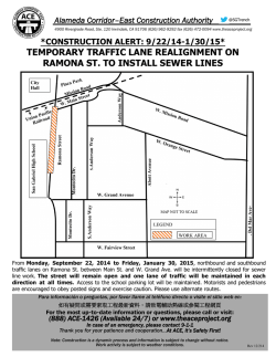
© Copyright 2026