
ASTEROID CARTOGRAPHY: MAPPING VERY ELONGATED
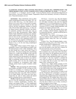
46th Lunar and Planetary Science Conference (2015)
1018.pdf
ASTEROID CARTOGRAPHY: MAPPING VERY ELONGATED OBJECTS. P. J. Stooke1, 1Department of
Geography and Centre for Planetary Science and Exploration, The University of Western Ontario, London, Ontario,
Canada N6A5C2, [email protected], http://publish.uwo.ca/~pjstooke/.
Introduction:
Cartography of non-spherical
worlds began with Phobos and Deimos, imaged by
Mariner 9 in 1971-72. The first map of any nonspherical world was a chart of Phobos by Tom
Duxbury [1]. Since then many objects far more elongated than Phobos have been imaged and some have
been mapped, but the development of mapping methods for these objects is still in its infancy. I describe
work in this area and illustrate it with recent maps of
Eros, Ida, Itokawa and comet Borrelly.
Mapping: Data sources vary considerably: Borrelly is covered by only a few images, sufficient for a
simple shape model and low resolution coverage of
30% of the surface, Toutatis by effectively one visual
image (Chang’E 2) plus a radar shape model. At the
other extreme is Eros with over 170,000 images giving
global high resolution coverage and both laser altimetry and an image-derived shape. From a shape model,
a coordinate system can be defined and at that point the
surface can be mapped into any desired map projection
analytically or via a large number of control points
(features or grid intersections).
The process just described works perfectly for a
spherical world, but as shapes depart from a sphere the
last step, the map projection, can cause difficulties
which become more pronounced for extreme shapes
including very elongated objects. A variety of map
projections have been devised to use with nonspherical objects, e.g. [2], [3], [4]. Which work best
for very elongated objects? Note that other approaches
are also possible, including 3-D visualizations which
can be overlaid with multiple data sets and viewed
from any direction in specialized GIS settings, but this
study is concerned only with flat maps suitable for use
in hardcopy or presentation slide formats.
Map Projections: The most common global map
projection in the small body literature is Simple Cylindrical (SC), sometimes replaced by Mercator with two
polar insets (e.g. [1]). SC is easy to understand, and
particularly valuable as an image database or archive
format from which any other projection or rendered
visualization might be derived. (Sinusoidal projections
contain the same information in a smaller file (less redundancy at high latitudes) and enjoyed a brief popularity when computer memory was limited.) SC distorts polar regions of a sphere but shows low latitudes
very well, but on very elongated objects the equatorial
region suffers large variations in scale and significant
shape distortions. Bugaevsky [5] alleviated this by
expanding grid cells at the ends of the body, which
works well for Phobos but perhaps less well for very
elongated objects. Further experiments with this method on progressively more complex shapes would be
desirable.
Multiple Orthographic views are also common, typically six viewed from mutually orthogonal directions
[6]. They are easy to interpret but lack the inherent
simplicity and continuity of a single global map and the
capability of easy reprojection.
The Morphographic approach [7] is explored here
in a particular variant: projecting the irregular shape
onto a best-fit or similar triaxial ellipsoid which is then
flattened into two opposite half-body maps (north and
south, or 90° and 270° longitude if 0° is at one end).
The projection duplicates the expansion of grid cells at
the ends of the body, providing half-body maps which
are easy to relate to images, something often very difficult to do with cylindrical maps. Figure 1 shows samples of these maps for Eros, Ida, Itokawa and comet
Borrelly. Borrelly’s map control is derived from [8].
In each case the elongated bodies have been projected
onto a generic elongated grid (morphographic azimuthal equidistant) originally scaled to suit Eros, but used
here for convenience with several bodies having similar axial ratios.
This is not the only approach which might be used
for highly elongated objects. Planetocentric coordinates might be abandoned in favour of a cylindrical
coordinate system with a long axis coinciding with that
of the ellipsoid. Two coordinates, distance along the
axis and azimuth around it, would define positions.
The ends might be mapped onto plane or hemispheric
caps and portrayed in insets, as polar insets are used
with Mercator projections [1].
References:
[1] Duxbury, T. Icarus 23.2 (1974): 290-299.
[2] Snyder Survey Review 28.217 (1985): 130-148.
[3] Nyrtsov, M. V. and Stooke, P. J. Proc. Int. Conf.
InterCarto. Vol. 8. 2002. [4] Berthoud, M. G. Icarus
175.2 (2005): 382-389. [5] Bugaevsky, L. M. 5th Int.
Conf. Mars, Pasadena, CA. 1999. [6] Hudson, S. et
al., 2003. Icarus, 161, 346-355. [7] Stooke, P. J.,
1998. Canadian Geographer, 42, 61-78. [8] Howington-Kraus, E. et al., 2002. Int. Arch. Photogramm.
Remote Sens., XXXIV(4), # 277.
46th Lunar and Planetary Science Conference (2015)
1018.pdf
Figure 1. Maps of 4 small bodies in a Morphographic Equidistant projection on an elongated ellipsoid base

© Copyright 2026