
NEW OBSERVATIONS OF MARTIAN OUTFLOW CHANNEL FLOOD
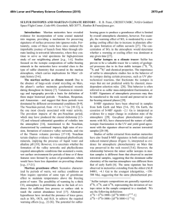
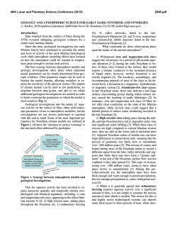
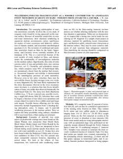
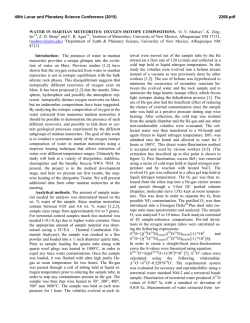
46th Lunar and Planetary Science Conference (2015)
2979.pdf
NEW OBSERVATIONS OF MARTIAN OUTFLOW CHANNEL FLOOD DEPOSITS. J. W. Rice1 and V. R.
Baker2, 1Planetary Science Institute, 1700 E. Ft. Lowell Rd., Suite 106, Tucson, AZ 85719 ([email protected]) 2Dept of
Hydrology and Water Resources, Harshbarger Bldg Rm 122, PO Box 210011, University of Arizona, Tucson, AZ
85721.
Introduction: During the past forty years numerous
scenarios have been proposed for the creation of the
Martian outflow channels ranging from mega floods,
volcanic dikes followed by groundwater release, lava
flows, debris flows, glaciers, and explosive carbon
dioxide outgassing. Today most workers favor water as
the major outflow channel forming medium, however
considerable uncertainty remains about the amounts of
water and sediment involved (e.g., sediment-charged
floods or water-rich debris flows). It should be noted
that this result is based primarily on the presence of a
suite of erosional landforms (cataracts, longitudinal
grooves, streamlined hills).
To date no clear Martian flood deposits, bed forms
or deltas have been identified associated with the outflow channels. However, here we present for the first
time new observations that these heretofore enigmatic
deposits and bedforms have been located. Our preliminary photogeologic analysis of the high resolution images indicates that these channels contain a rich inventory of both erosional and depositional landforms.
HiRISE imagery of the Martian outflow channels does
show morphological differences, albeit subtle in most
cases, between the channel floors and the surrounding
regions unaffected by the floods. More detailed mapping of depositional bedforms on Mars will provide
additional constraints on the surface hydraulics, erosion and sedimentary processes.
Methods: Most of the diagnostic clues used to identify the largest terrestrial catastrophic floods in the
Channeled Scabland and Iceland are based on landform assemblages and associations [1,2,3]. These clues
also depend on geologic context and often require the
preponderance of observational data to properly identify flood features. Our extensive experience in field
geology investigations of large scale floods in both the
Channeled Scabland and Iceland indicate that no one
feature or landform can be used to properly identify
paleofloods.
This same methodology (landform assemblages and
associations) is used in our analysis the Martian outflow channels. We use the hierarchical classification
scheme developed by Baker [1, 2] to search for and
describe Martian macroform and mesoform landforms.
Macroforms are scale controlled by channel width and
some examples are streamlined hills, rock benches,
pendant bars, and expansion bars. Catastrophic floods
also produce mesoforms which are scale controlled by
channel depth. Mesoforms include large scale transverse ripples, boulder bars, inner channels, cataracts,
and longitudinal grooves.
Observations: The most obvious morphologic signature associated with the unconfined outwash regions
(basin ward of channel mouths) of the outflow channels is a rippled texture on the plains [Figs. 1 and 2].
Figure 1. Regional HiRISE view illustrates relationship of rippled plains overlying smoother plains. The
rippled plains form a relatively thin deposit that is being stripped away in places revealing lower smoother
plains material. We interpret the rippled plains to be
flood deposits. Solar illumination is from lower left in
both images.
Figure 2. Rippled Plains north of Ares Vallis showing generally straight ridges running from upper left to lower right
with orientations transverse to inferred flood flow direction.
On the right side of this image Transverse Aeolian Ridges
(TARs) are visible. Note how the transverse ridges differ
morphologically from the TARs.
This ripple-like texture lies transverse to flow direction. This texture is commonly observed in regions
affected by the Ares and Tiu Valles floods in
Chryse/Acidalia Planitia. Malin and Edgett [4] noted
that the outflow channel surfaces in Chryse and Acida-
46th Lunar and Planetary Science Conference (2015)
lia Planitia were typically pitted and had a rippled texture. They were not really certain what to make of this
texture in terms of flood processes. Here we propose
that this rippled texture is the morphologic signature of
fluvial bedforms (antidunes or transverse ribs) of the
last floods to flow through these regions of
Chryse/Acidalia Planitia.
We have conducted some preliminary quantitative
studies of a mesoscale bedforms (ridges), observed on
the rippled plains near the mouth of the Tiu Valles
outwash region in Chryse Planitia. We propose that
features are antidunes/transverse ribs based on the
morphometric analysis. We measured these features
and found that the average wavelength, is 53.6 m. The
equations developed by [9] were then applied to these
features in order to calculate and help constrain the
velocity, depth and Froude number of the floods. The
following results were obtained by using these equations: mean velocity of 6 m/s; flow depths ranging
from a minimum of 5.5 m to a maximum of 19 m; and
Froude numbers ranging from 0.7 to 1.3, which is the
range associated with antidune flow. The features
measured here were most likely deposited during the
last floods through this region. This would be analogous to the catastrophic floods responsible for the
Channeled Scabland, which undergo an abrupt cessation of flood discharge which results in the preservation of many of the mesoforms.
We have also observed large sub-rounded boulder
deposits (bedload) located on the floors of some outflow channels where they empty into the Chryse basin
(Fig. 3). Some of these boulders are up to 15 m across
and display corner knicks or chips whiche we interpret
to be perussion marks created during flood transport.
Figure 3. Large boulder field found on the floor of
Ares Vallis.
Conclusions: This information will allow us to reconstruct the paleoflood depths and velocities for the
outwash plains of Chryse/Acidlalia Planitia. This information when combined with our future hydraulic
modeling task for the five outflow channels in our
2979.pdf
MDAP funded research will provide new data on the
nature and dynamics of these Martian paleofloods.
Some of the most important issues involving the
formation of fluvial landforms on Mars relate to the
water source, which mechanisms and processes combined to modify the surface, and the ultimate fate of
the water and sediment after transport into depositional
sinks. These results will enable us to more fully understand the role water played in the origin and evolution
of the outflow channels and aid in reconstructing the
global hydrologic cycle of Mars.
References: [1] Baker, V.R. (1973) GSA Special Pa
per, 144, 79pp. [2] Baker, V.R. (1978) Channeled
Scabland: Field Conf. Guidebook, pp. 17-35. NASA.
[3] Rice, J.W. et al. (2000) 2nd Intl. Mars Polar Conf.,
Abstract #4098. [4] Malin, M. C., and K. S. Edgett
(2003) Science, v. 302, 1931-34. [5] Carling, P.A.
(1999) J. Sed. Res., 69, 534–545. [6] Rice, J. W., et
al.,(2002), Lunar Planet. Sci. XXXIII,abstract 2026.[7]
Burr, D.M., et al., (2004) Icarus, v. 171, p. 68-83. [8]
Alexander, J. and Fielding, C. (1997) Sedimentology,
44, 327–337. [9] Koster, E. H.(1978) Canadian Society
of Petroleum Geologists Memoir, 5, pp. 161–186.
![View announcement [PDF 708.48 kB]](http://s2.esdocs.com/store/data/000465700_1-0b7c69c680e3fa00ddd1676cc9494343-250x500.png)
© Copyright 2026