
RIPPLE ORIENTATIONS AS AN INDICATION OF RECENT WINDS
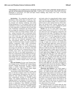
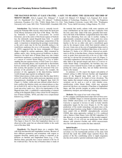
46th Lunar and Planetary Science Conference (2015)
1539.pdf
RIPPLE ORIENTATIONS AS AN INDICATION OF RECENT WINDS ON MARTIAN DUNES. M. B.
Johnson1 and J. R. Zimbelman1, 1Center for Earth and Planetary Studies, MRC 315, National Air and Space Museum, Smithsonian Institution, Independence Avenue and 6th Street SW, Washington, DC 20013, [email protected].
Introduction: Sand dunes on both Earth and Mars
have been shown to preserve the most recent wind patterns in their ripple formations [1, 2]. This investigation, supported by NASA MDAP grant NNX12AJ38G,
continues the documentation of ripples on martian
dunes in order to assess recent surface wind flow [3].
This information will provide insight into the modes of
dune formation and ripple morphology, and offer current constraints for global circulation models.
Background: Movement of martian sand ripples
was first observed by the Spirit rover [4] and is now
studied with images from the High Resolution Imaging
Science Experiment (HiRISE) camera [5]. This instrument provides unprecedented views of Mars, including
sand dunes in diverse areas with resolution as high as
25 cm/pixel [6]. Some dunes have complex structures
and crest positions which may have been created by
multiple wind directions or seasonal wind variations.
Being unable to determine between multiple possible
wind regimes leaves dune morphologies open to interpretation. However, dune crests and ripples mapped by
Neilson and Kocurek show that the ripple-scale patterns are a better indicator of recent wind flow which
modify the principle crests [1]. This same mapping
technique can be used to document recent flows on
Mars. Because wind speeds have yet to be measured
directly in many areas, we must rely on high resolution
images and ripple scale features for recent wind information.
Methodology: Martian study sites in this investigation must have clear HiRISE frames and be able to
represent diverse locations across the surface, decided
primarily by their latitude and longitude. Frames with
stereo pairs are preferred because of their ability to
create digital terrain models (DTMs) with 3D modeling
software such as SOCET SET. The resulting 30 frames
studied to date are indicated in Table 1. The ripple
documentation method for the first 7 images was the
Java Mission-planning and Analysis for Remote Sensing (JMARS) geospatial information system (GIS)
while the remaining images were studied using ESRI’s
Arc GIS. In both systems, lines were drawn perpendicular to ripple crests across three adjacent ripples in
order to document ripple wavelength from line length
and inferred wind direction from azimuth (Figure 1). It
is not possible to infer a unique wind direction from
ripple orientation alone and therefore these inferred
directions have a 180 degree ambiguity [7]. For example, a crest with North-South alignment may have been
constructed by an Easterly, Westerly, or bi-directional
wind. Due to this ambiguity, results presented in this
study will assume azimuths to be between 0 and 180
degrees. Actual orientations may be defined after further study by using additional information about dune
morphology, such as known dune types, and the rule of
maximum gross bedform-normal transport [8]. Ripples
in each study site are then categorized by the cardinal
wind direction they suggest and percentages of each
inferred direction are calculated. Percentages of wavelength values are also displayed in order to look for
possible patterns. In some areas with DTMs, inferred
wind direction is compared to the slope magnitude on
which the ripple formed. This gives an idea of how
great the effect of slope may be on ripple orientation by
the process described by Howard [9].
Site Region
1 Hellespontus
2 Gale Crater
3 Nili Patera
4 North Polar
5 Aonia Terra
6 Lus Chasma
7 Arabia Terra
8 Terra Cimmeria
9 Lyot Crater
10 Icaria Planum Crater
11 South of Promethei Terra
12 Terra Sirenum
13 Vastitas Borealis
14 Milankovic Crater
15 Becquerel Crater
16 Terra Tyrrhena
17 Gamboa Crater
18 Aeolis Mensae
19 Wirtz Crater
20 Near Cerberus Fossae
21 Coprates Chasma
22 Kaiser Crater
23 North Polar
24 Syrtis Major Planum
25 West of Daedalia Planum
26 Herschel Crater
27 Capen Crater
28 South of Valles Marineris
29 Promethei Terra
30 Terra Sirenum
HiRISE frame ID
Lon E
Lat
PSP_007663_1350
38.779 -44.859
PSP_009571_1755 137.497 -4.463
ESP_017762_1890
67.321
8.779
PSP_010019_2635 118.543 83.505
ESP_013785_1300
293.1 -49.804
ESP_027341_1720
276.387 -7.718
ESP_016459_1830
4.553
3.12
ESP_025645_1455
138.437 -34.23
PSP_009746_2290
29.287 48.864
ESP_029478_1350
259.932 -44.482
ESP_022731_1080
143.002 -71.68
ESP_023928_1205
218.035 -59.098
ESP_018925_2520
344.658 71.906
ESP_018930_2350
213.42 54.576
PSP_001955_2015 351.899 21.445
ESP_026675_1655
97.769 -14.552
PSP_002721_2210 315.704
40.78
PSP_010178_1825 122.357
2.247
ESP_021603_1315
334.681 -48.256
PSP_008449_1885 169.194
8.566
ESP_026905_1660
296.894 -14.092
PSP_007110_1325
18.794 -46.98
ESP_027474_2610
223.471 80.832
ESP_019845_2000
79.425 19.823
ESP_024838_1630
207.988 -16.72
PSP_006974_1635
128.39 -16.391
ESP_026757_1865
13.958
6.349
ESP_025625_1580
320.382 -21.603
ESP_023285_1230
133.179 -56.923
ESP_023731_1405
195.967 -38.96
Table 1: Information for the 30 study sites where ripple
measurements have been recorded to date. Sites are listed in
order of completion.
46th Lunar and Planetary Science Conference (2015)
Terra Sirenum Observations: One site explored
in this study is in Terra Sirenum (HiRISE frame
ESP_023928_1205), where 333 ripples were recorded
and analyzed for dominant wind direction, emerging
patterns of ripple wavelength, and effect of slope on
ripple deflection. The percent of measurements in each
each direction are as follows: 1% ESE-WNW wind,
36% SE-NW, 38% SSE-NNW, 24% S-N, and the remaining 1% SSW-NNE. This shows that the wind is
likely from the SSE with additional ripples centered
around this direction. The wavelengths varied from 2
to 4 meters and the distributions show that 3 to 4 meter
wavelengths make up the majority of measurements in
the ESE and SE while 2 to 3 meter wavelengths make
up the majority of SSE, S, and SSW measurements. It
is not yet clear whether there is a relationship between
the two. The slope distribution shows that very few
(about 5%) measurements were on slopes of larger than
15 degrees, which is not an adequate number for affirming significance. However, these measurements fell
into two of the larger categories (SSE and S), which
does not indicate a tendency toward anything other
than the same distribution. Further investigation into
one small dune in this frame (Figure 2) shows that
while the angle between the direction of inferred wind
and direction of maximum slope ranges between 13
and 87 degrees, the dune shape suggests NW-SE wind
on the majority of the dune with some variation on the
base of the eastern side, where form flow would occur.
This indicates again that slope does not seem to have a
large affect on ripple orientation and deflection.
Figure 1: Ripple mapping of HiRISE frame
ESP_025645_1455. Note that areas with clear ripple definition for tens of meters contain measurements while areas
with overlapping patterns have been avoided.
1539.pdf
Figure 2: Subscene of HiRISE frame ESP_023928_1205
with blue lines indicating ripple measurements and red lines
indicating the direction of maximum slope.
Results: This study has yielded several preliminary results. Firstly, the martian surface supports many
dune types, including barchan and linear, in areas with
adequate sand supply. The complexity of ripple patterns varies from uniform directionality for hundreds of
kilometers to complex, overlapping patterns which
create areas that cannot be documented by this process.
These suggest the existence of multiple dominant, perhaps seasonally varying winds. The study of individual
frames has indicated that there may be a relationship
between wavelength and azimuth, though more study is
needed. It has also suggested that slope angle does not
have a significant effect on ripple formation with regards to orientation. The study of additional frames
will expand our understanding of these relationships.
References: [1] Neilson J. and Kocurek G. (1987)
Geol. Soc. Am. Bull., 99, 177-186. [2] Ewing R. C. et
al. (2010) J. Geophys. Res., 115, E8. [3] Zimbelman J.
R. (2011) NSPIRES NNH11ZDA001N-MDAP. [4]
Sullivan R. et al. (2008) J. Geophys. Res., 113, E6. [5]
Bridges N. T. et al. (2012) Nature, 485, 339-342. [6]
McEwen A. S. et al. (2007) J. Geophys. Res., 112, E5.
[7] Sharp R. P. (1963) J. Geology, 71, 617-636. [8]
Fenton, L. K. et al. (2014) Icarus, 230, 5-14. [9] Howard A. D. (1977) Geol. Soc. Am. Bull., 88, 853-856.


© Copyright 2026