
1-7 i - Environmental Clearances
RAPID ENVIRONMENTAL IMPACT ASSESSMENT REPORT & ENVIRONMENTAL MANAGEMENT PLAN FOR PROPOSED RIVER SAND MINING PROJECT AT REVENUE VILLAGES OF TEHSIL:BEGUN, DISTRICT: CHITTORGARH, RAJASTHAN MINING LEASE AREA :286.43 Ha. (NON FOREST) PRODUCTION CAPACITY: 1.68 LTPA M.L. No :07/2012 STUDY PERIOD – POST- MONSOON (OCT-DEC 2013) Consultant: Enviro Concept (I) Pvt. Ltd. Proponent: (Environmental Engineer & Consultants) 1/3 A,Yudhister Marg, C-Scheme, Jaipur Telefax: 0141- 2223290, M: +919829118043 Committed to Sustainable Development RAPID EIA/EMP REPORT FOR RIVER SAND MINING PROJECT AT TEHSIL: BEGUN, CHITTORGARH (RAJ.) 2014-15 PREFACE M/s Rajasthan Fort and Pal ace Pvt. Ltd. propose to develop a River Sand mining in, Revenue Village (Covering 17 Villages) of Tehsil: Begun, District: Chittorgarh, Rajasthan having lease area of 286.43 Ha. The land form is mostly river bed and non-forest land. The River beds area is belong to Government land as per revenue records. Letter of intent (LOI) for mining lease for 286.43 Ha area has been granted in favor of M/s Rajasthan Fort and Palace Pvt. Ltd. vide letter No. funs@i 2¼,-3½fpRrkSM@ctjh@2012@837 dated 30.11.2012. TOR was granted vide letter No. No. J11015/212/2013-IA.II (M) dated 14.10.2013. The goal of the project is to provide sand for various construction as well as Infrastrurals projects. Baseline data collection i.e. Air Quality, Water Quality, Noise Quality, & Soil Quality were collected during Post Monsoon Period 2013 by Noida Testing Laboratories, Greater Noida (NABL Accredited Laboratories). Secondary data has been collected from Indian Meteorological Department, Jaipur (IMD), Water Resource Department, Central Ground Water Board, Forest & Census Department etc. A final Environmental Impact Assessment report was prepared to comply with the terms of reference (TOR). As per the provisions of Environmental Impact Assessment Notification dated 14.09.2006 issued by Ministry of Environment and Forests, Govt. of India; Public Hearing was conducted at 11.00 AM on 01.10.2014, in the premises of Aaganbadi, Gram Panchyat: Etawaha Village: Luhariya, Tehsil: Begun, District: Chittorgarh, under the Chairmanship of ADM Shri Harji Lal Atal for, Proposed River Sand Mining Project located at Revenue villages of Tehsil: Begun, District: Chittorgarh, Rajasthan. Advertisement for conducting public hearing was published on 26.08.2014 in “Hindustan Times” & “Rajasthan Patrika” and dated1.10.2014 in “Hindustan Times” & “Rajasthan Patrika”. We are committed to follow the proposed EMP in this EIA Report as an Environment Policy of the Company. We also hereby undertake that all the points raised in the TOR issued by MOEF are complied with I also undertake that the facts given in the Rapid EIA/EMP report are factually correct to the best of our knowledge. M/s. Rajasthan Fort and Palace Pvt. Ltd. Project Proponent Date: 23-01-2015 F//FREIA.201411 Devendra Goyal EIA Coordinator 1 RAPID EIA/EMP REPORT FOR RIVER SAND MINING PROJECT AT TEHSIL: BEGUN, CHITTORGARH (RAJ.) ABBREVIATION EIA EMP MOEF TOR EAC EC SEAC SPCB CPCB DMG NOC BGL GLC NH SH dB LEQ HA UNFC LOI KLD LTPA KM PRA FGD RL EPA DO COD TKN PM AAQ LTPA R&R CSR EMC GOR NGO HMV F//FREIA.201411 ENVIRONMENTAL IMPACT ASSESSMENT ENVIRONMENT MANAGEMENT PLAN MINISTRY OF ENVIRONMENT AND FOREST TERMS OF REFERENCE EXPERT APPRAISAL COMMITTEE ENVIRONMENT CLERANCE STATE EXPERT APPRAISAL COMMITTEE STATE POLLUTION CONTROL BOARD CENTRAL POLLUTION CONTROL BOARD DEPARTMENT OF MINING & GEOLOGY NO OBJECTION CERTIFICATE BELOW GROUND LEVEL GROUND LEVEL CONCENTRATION NATIONAL HIGHWAY STATE HIGHWAY DECIBEL EQUIVALENT NOISE LEVEL HECTARE UNITED NATIONS FRAMEWORK CLASSIFICATION LETTER OF INTENT KILO LITRE PER DAY LAC TONNE PER ANNUM KILO METER PARTICIPATORY RURAL APPRAISAL FOCUS GROUP DISCUSSION RIVER LEVEL THE ENVIRONMENT PROTECTION ACT DISSOLVED OXYGEN CHEMICAL OXYGEN DEMAND TOTAL KJELDAHL NITROGEN PARTICULATE MATTER AMBIENT AIR QUALITY LAC TONNES PER ANNUM REHABILITATION & RESETTLEMENT CORPORATE SOCIAL RESPONSIBILITY ENVIRONMENTAL MANAGEMENT CELL GOVERNMENT OF RAJASTHAN NON GOVERNMENTAL ORGANIZATION HEAVY MOTOR VEHICLE 2 2014-15 RAPID EIA/EMP REPORT FOR RIVER SAND MINING PROJECT AT TEHSIL: BEGUN, CHITTORGARH (RAJ.) 2014-15 TABLE OF CONTENT S. No. 1 2 CHAPTER 1 1.0 1.1 1.1.1 1.2 1.3 1.4 1.5 1.6 1.7 1.8 1.9 1.10 1.10.1 1.10.2 1.10.3 1.11 1.12 1.13 CHAPTER 2 2.0 2.1 2.1.1 2.1.2 2.1.3 2.1.4 2.2 2.3 2.3.1 2.3.2 2.3.3 2.3.4 2.4 2.4.1 2.4.2 2.5 2.5.1 2.5.2 2.5.3 2.5.4 2.5.5 2.5.6 F//FREIA.201411 PARTICULARS FORM-1 EXECUTIVE SUMMARY HINDI & ENGLISH INTRODUCTION PREAMBLE GENERAL INFORMATION ON MINING OF MINERALS RIVER SAND MINING AND ITS USES PURPOSE OF REPORT ENVIRONMENTAL CLEARANCE PROCESS COMPLIANCE TO THE TERMS OF REFERENCE POST ENVIRONMENTAL CLEARANCE MONITORING GENERIC STRUCTURE OF ENVIRONMENTAL IMPACT ASSESSMENT DOCUMENT IDENTIFICATION OF PROJECT PROPONENT BRIEF DESCRIPTION OF PROJECT REGULATORY COMPLIANCES & APPLICABLE LAWS/REGULATIONS INFRASTRUCTURE NEAREST RAILWAY STATION NEAREST AIRPORT NEAREST HIGHWAY COST OF THE PROJECT ENVIRONMENTAL IMPACT ASSESSMENT REPORT SCOPE OF WORK PROJECT DESCRIPTION GENERAL DESCRIPTION OF THE PROJECT LOCATION DETAILS NEED FOR THE PROJECT & IMPORTANCE TO THE COUNTRY OR REGION DEMAND AND SUPPLY GAP EXPORT POSSIBILITY LEASEHOLD AREA GEOLOGY REGIONAL GEOLOGY LOCAL GEOLOGY ESTIMATION OF RESERVES QUALITY OF RESERVES TYPES OF MINING WORKING DEPTH PRODUCTION DETAILS GENERAL FEATURES PHYSIOGRAPHY SURFACE DRAINAGE PATTERN VEHICULAR TRAFFIC DENSITY TOWNSHIP INFRASTRUCTURE POWER, WATER SUPPLY AND OTHER INFRASTRUCTURE REQUIREMENT 3 PAGE NO. 1-9 10-23 24-42 24 24 24 25 26 27 38 38 39 39 41 42 42 42 42 42 42 42 43-53 43 44 44 45 45 46 46 46 47 47 47 48 49 50 50 51 51 51 51 51 51 51 RAPID EIA/EMP REPORT FOR RIVER SAND MINING PROJECT AT TEHSIL: BEGUN, CHITTORGARH (RAJ.) 2.6 2.7 CHAPTER 3 3.0 3.1 3.2 CHAPTER 4 4.0 4.1 4.1.1 4.1.2 4.1.3 4.1.4 4.1.5 4.2 4.2.1 4.2.1.1 4.2.2.2 4.2.2.3 4.3 4.3.1 4.3.1.1 4.3.1.2 4.3.1.3 4.3.2 4.3.3 4.3.4 4.3.5 4.4 4.4.1 4.4.2 4.4.3 4.4.4 4.4.5 4.4.6 4.4.7 4.4.8 4.4.9 4.5 4.5.1 4.5.2 4.5.3 4.6 4.6.1 4.6.2 4.6.3 4.6.4 4.6.5 4..6.6 F//FREIA.201411 MANPOWER REQUIREMENTS PROJECT IMPLEMENTATION SCHEDULE ANALYSIS OF ALTERNATIVES ANALYSIS OF ALTERNATIVE SITES ANALYSIS OF ALTERNATIVE TECHNOLOGY SELECTION OF MINING METHODOLOGY DESCRIPTION OF ENVIRONMENT GENERAL LAND ENVIRONMENT OBJECTIVE METHODOLOGY LAND USE PATTERN TOPOGRAPHY SEISMICITY OF THE AREA PHYSIOGRAPHY & DRAINAGE PATTERN SOIL ANALYSIS SOIL SAMPLING LOCATION SOIL MONITORING RESULTS CONCLUSION WATER ENVIRONMENT GROUND WATER GROUNDWATER SCENARIO AQUIFER TYPES GEOMORPHOLOGY & DRAINAGE WATER QUALITY WATER SAMPLING LOCATIONS MONITORING RESULTS CONCLUSION AIR ENVIRONMENT METEOROLOGY CLIMATOLOGY SITE SPECIFIC MICRO METROLOGICAL DATA WIND ROSE AMBIENT AIR QUALITY (AAQ) AIR QUALITY MONITORING LOCATIONS METHODOLOGY ADOPTED FOR AIR QUALITY MONITORING RESULT AND CONCLUSION MINERALOGICAL COMPOSITION FOR PM10 NOISE ENVIRONMENT INSTRUMENT USED FOR SAMPLING AND MONITORING NOISE QUALITY MONITORING LOCATIONS RESULTS AND CONCLUSIONS BIOLOGICAL ENVIRONMENT ENDANGERED/ THREATENED/ ENDEMIC ANIMALS FLORA IN CORE ZONE FAUNA IN CORE ZONE FLORA IN BUFFER ZONE FAUNA IN BUFFER ZONE CONSERVATION PLAN FOR PEACOCK 4 2014-15 53 53 54 54 54 54 55-102 55 58 59 59 59 61 63 63 65 66 67 67 67 68 68 70 70 73 73 73 74 74 75 75 75 76 77 78 78 79 80 80 80 81 81 81 82 84 85 86 88 90 RAPID EIA/EMP REPORT FOR RIVER SAND MINING PROJECT AT TEHSIL: BEGUN, CHITTORGARH (RAJ.) 4.6.7 4.7 4.7.1 4.7.2 4.7.3 4.7.4 4.7.5 4.8 4.8.1 CHAPTER 5 5.0 5.1 5.1.1 5.1.2 5.1.3 5.2 5.2.1 5.2.2 5.2.3 5.3 5.3.1 5.3.2 5.3.3 5.3.4 5.3.5 5.3.6 5.4 5.4.1 5.4.2 5.5 5.6 5.6.1 5.6.2 5.6.3 5.6.4 5.7 5.7.1 5.7.2 5.7.3 5.8. 5.8.1 5.9 CHAPTER 6 6.1 6.2 6.3 6.3.1 6.3.2 6.3.3 F//FREIA.201411 IMPACT OF MINING ON PLANKTON SOCIO-ECONOMIC ENVIRONMENT OBJECTIVES OF THE STUDY SCOPE OF WORK METHODOLOGY BACKGROUND INFORMATION OF THE AREA DEMOGRAPHY OF THE STUDY AREA TRAFFIC ANALYSIS IMPACTS DUE TO TRANSPORTATION ANTICIPATED ENVIRONMENTAL IMPACTS & MITIGATION MEASURES GENERAL LAND ENVIRONMENT ANTICIPATED IMPACTS ON LAND ENVIRONMENT MITIGATION MEASURES SAND BUDGET & REPLENISHMENT STUDY WATER ENVIRONMENT ANTICIPATED IMPACT ON WATER ENVIRONMENT MITIGATION MEASURES RAIN WATER HARVESTING AIR ENVIRONMENT IMPACTS OF THE SAND EXCAVATION IMPACTS OF THE SAND LOADING IN TO TRUCKS MITIGATION MEASURES FOR AIR POLLUTION AIR QUALITY IMPACT PREDICTIONS (AQIP) AIR QUALITY MODELLING RESULTS AND CONCLUSION NOISE ENVIRONMENT ANTICIPATED IMPACTS MITIGATION SOLID/OB MANAGEMENT IMPACT ON BIOLOGICAL ENVIRONMENT IMPACT ON WILDLIFE IMPACT ON FLORA IMPACT ON FAUNA GREEN BELT DEVELOPMENT SOCIO- ECONOMIC ENVIRONMENT ANTICIPATED IMPACTS MITIGATION MEASURES CORPORATE SOCIAL RESPONSIBILITY ACTIVITIES MINE CLOSURE MINE CLOSURE CRITERIA STATUATORY REQUIREMENTS ENVIRONMENTAL MONITORING PROGRAMME SCOPE OF ENVIRONMENTAL MONITORING PROGRAM METHODOLOGY OF MONITORING POST PROJECT MONITORING PLAN AIR QUALITY MONITORING WATER QUALITY MONITORING NOISE LEVEL MONITORING 5 2014-15 94 95 95 95 95 96 96 101 102 103-122 103 103 104 104 105 112 112 112 112 112 113 113 113 113 115 118 118 118 118 119 119 119 119 119 119 119 119 120 121 122 122 122 123-126 123 123 124 124 124 125 RAPID EIA/EMP REPORT FOR RIVER SAND MINING PROJECT AT TEHSIL: BEGUN, CHITTORGARH (RAJ.) 6.3.4 6.4 6.5 CHAPTER 7 7.1 7.2 7.2.1 7.2.2 7.2.3 7.2.4 7.2.5 7.2.6 7.2.7 7.3 CHAPTER 8 8.0 8.1 8.1.1 CHAPTER 9 9.0 9.1 9.1.1 9.1.2 9.2 9.2.1 9.2.2 9.3 9.4 9.4.1 9.5 9.6 9.6.1 9.6.2 9.6.3 9.7 9.7.1 9.8 9.9 CHAPTER10 10.1 10.2 10.2.1 10.3 F//FREIA.201411 GREEN BELT DEVELOPMENT ENVIRONMENTAL MONITORING CELL REPORTING SCHEDULES OF MONITORED DATA ADDITIONAL STUDIES PUBLIC CONSULTATION IMPACTS DUE TO TRANSPORTATION RISK ASSESSMENT & DISASTER MANAGEMENT PLAN ACTIVITIES WITH POTENTIAL RISKS SAFETY OF MACHINE USE AT MINING SITE SAFETY MEASURES DURING WORKING AT SAND MINING SITE SAFETY MEASURES DURING SAND TRANSPORTATION POSSIBLE RISKS DUE TO FAILURE OF WATSTE DUMP & ITS CONTROL OTHER POSSIBLE MEASURES TO AVOID RISKS/ DISASTER DUE TO RIVER BED MINING OCCUPATIONAL HEALTH & SAFETY (OHS) PROJECT BENEFITS GENERAL EMPLOYMENT GENERATION IMPROVEMENTS IN PHYSICAL AND SOCIAL INFRASTRUCTURE ENVIRONMENTAL MANAGEMENT PLAN GENERAL AIR POLLUTION CONTROL CONTROL OF GASEOUS EMISSIONS MEASURE TO CONTROL DUST INHALATION WATER MANAGEMENT & WATER POLLUTION CONTROL SURFACE WATER GROUND WATER NOISE POLLUTION CONTROL MEASURES LAND ENVIRONMENT POST MINING LAND USE SOIL CONSERVATION BIOLOGICAL ENVIRONMENT GREENBELT DEVELOPMENT PLANTATION PROGRAMME GENERAL GUIDELINES FOR GREEN BELT DEVELOPMENT SOCIO-ECONOMIC ENVIRONMENT ANTICIPATED IMPACTS AND EVALUATION OCCUPATIONAL HEALTH & SAFETY BUDGETARY PROVISION FOR EMP IMPLEMENTATION & MONITORING SUMMARY AND CONCLUSION INTRODUCTION OF PROJECT & PROPONENT PROJECT DESCRIPTION DESCRIPTION OF SAND MINING OPERATION ANALYSIS OF ALTERNATIVE SITES 6 2014-15 125 125 126 127-133 127 131 131 131 131 131 132 132 132 132 134 134 134 134 135-141 135 135 136 136 136 136 136 136 137 137 137 138 138 138 139 140 140 140 140 142-147 142 143 143 143 RAPID EIA/EMP REPORT FOR RIVER SAND MINING PROJECT AT TEHSIL: BEGUN, CHITTORGARH (RAJ.) 10.4 10.5 10.5.1 10.5.2 10.6 10.7 10.8 10.9 10.9.1 10.9.2 10.9.3 10.9.4 10.9.5 10.9.6 10.9.7 10.10 CHAPTER 11 DESCRIPTION OF THE ENVIRONMENT ANTICIPATED ENVIRONMENTAL IMPACTS AND MITIGATION MEASURES IMPACT DUE TO AIR POLLUTION AND ITS MANAGEMENT IMPACT DUE TO NOISE POLLUTION AND ITS MANAGEMENT ENVIRONMENT MONITORING PROGRAMME ENVIRONMENTAL MONITORING PLAN PROJECT BENEFIT ENVIRONMENT MANAGEMENT PLAN AIR QUALITY MANAGEMENT WATER QUALITY MANAGEMENT NOISE MANAGEMENT SOLID WASTE MANAGEMENT MANAGEMENT OF LAND USE PATTERN GREEN BELT DEVELOPMENT & PLANTATION PROGRAMME SOCIO-ECONOMIC ENVIRONMENT CONCLUSION DISCLOSURE OF CONSULTANTS QUESTIONNAIRE 2014-15 143 145 145 145 146 146 146 146 146 146 146 147 147 147 147 147 148 LIST OF TABLES TABLE NO. 1.1 1.2 2.1 2.2 2.3 2.4 2.5 2.6 2.7 2.8 2.9 2.10 2.11 2.12 4.1 4.2 4.3 4.4 4.5 4.6 4.7 F//FREIA.201411 DETAILS COMPLIANCE TERMS OF REFERENCE (TOR) SALIENT FEATURES OF THE PROPOSED PROJECT NAME OF VILLAGES COVERING LEASE AREA BREAK-UP OF LEASE AREA REGIONAL LITHOSTRATIGRAPHY OF AREA STRATIGRAPHICAL SEQUENCES OF ROCKS BLOCKED RESERVES AS PER UNFC CODE (211 & 122) GRADE & USES OF RIVER SAND MINING DETAILS BLOCK WISE PROPOSED PRODUCTION PROPOSED PRODUCTION WATER REQUIREMENT LIST OF MACHINERY EMPLOYMENT DETAILS ENVIRONMENTAL SETTING OF THE STUDY AREA TEST METHODOLOGY FOR ENVIRONMENTAL MONITORING AND TESTING LAND USE/LAND COVER CLASS DISTRIBUTION SLOPE RATIO SOIL SAMPLING LOCATION SOIL ANALYSIS RESULTS GROUND WATER RESOURCES AND DEVELOPMENT POTENTIAL OF CHITTORGARH DISTRICT 7 RAPID EIA/EMP REPORT FOR RIVER SAND MINING PROJECT AT TEHSIL: BEGUN, CHITTORGARH (RAJ.) 4.8 4.9 4.10 4.11 4.12 4.13 4.14 4.15 4.16 4.17 4.18 4.19 4.20 4.21 4.22 4.23 4.24 4.25 4.26 4.27 4.28 4.29 4.30 4.31 4.32 4.33 4.34 4.35 4.36 4.37 4.38 4.39 4.40 4.41 4.42 4.43 4.44 4.45 4.46 4.47 5.1 5.2 5.3 5.4 5.5 5.6 F//FREIA.201411 2014-15 WATER SAMPLING LOCATION WATER MONITORING RESULTS MICRO METROLOGICAL DATA FOR THE STUDY PERIOD FREQUENCY DISTRIBUTION (24 Hrs.) MONITORED PARAMETERS AND FREQUENCY OF SAMPLING LOCATION OF AIR MONITORING STATIONS METHODS ADAPTED FOR PM10, PM2.5, SO2, NOx & CO SUMMARY OF AIR QUALITY MONITORING RESULTS CLASSIFICATION OF RSPM LOCATION OF NOISE MONITORING STATIONS NOISE QUALITY MONITORING RESULTS METHODS USED FOR SAMPLING OF FLORA AND FAUNA FEW RESERVED & PROTECTED FORESTS WITHIN 10 KM RADIUS OF THE MINE LEASE BOUNDARY LIST OF TREE SPECIES RECORDED IN THE CORE AREA LIST OF SHRUBS LIST OF HERBS LIST OF GRASSES LIST OF CLIMBERS LIST OF AVIFAUNA LIST OF MAMMALS LIST OF REPTILES LIST OF BUTTERFLIES LIST OF TREES (BUFFER ZONE) LIST OF SHRUBS LIST OF HERBS LIST OF GRASSES LIST OF AVIFAUNA LIST OF MAMMALS LIST OF REPTILES LIST OF BUTTERFLIES BUDGET FOR CONSERVATION OF PEAFOWL LIST OF PLANKTON DEMOGRAPHY WORKING & NON WORKING OCCUPATIONAL STRUCTURE LITERACY EDUCATION FACILITIES MEDICAL FACILITIES DRINKING WATER FACILITIES TRAFFIC MEASUREMENT RESULTS LAND USE PATTERN OF MINING LEASE AREA AT VARIOUS PHASES ANNUAL SEDIMENT YIELD IN THE INDIAN ARID ZONE AREA SOURCE EMISSION – SAND EXCAVATION HAULAGE EMISSIONS (UNPAVED) – TRANSPORT OF SAND PREDICTED 24-HOURLY SHORT TERM INCREMENTAL CONCENTRATIONS CUMULATIVE CONCENTRATION OF PM10, PM2.5 (BASELINE + INCREMENTAL) 8 RAPID EIA/EMP REPORT FOR RIVER SAND MINING PROJECT AT TEHSIL: BEGUN, CHITTORGARH (RAJ.) 5.7 5.8 6.1 7.1 9.1 9.2 9.3 9.4 10.1 10.2 2014-15 IMPACTS DUE TO ACTIVITY DETAILS OF CSR POST PROJECT MONITORING PROGRAMME PUBLIC HEARING ACTION PLAN LAND USE PATTERN OF MINING LEASE AREA AT VARIOUS PHASES GREENBELT DEVELOPMENT PROGRAMME NAME OF PLANTS FOR GREEN BELT DEVELOPMENT ANNUAL CAPITAL COST FOR ENVIRONMENTAL PROTECTION MEASURES DETAILS OF ENVIRONMENTAL SETTING SALIENT FEATURES OF THE PROJECT LIST OF FIGURES Fig. No. DETAILS 1.1 PRIOR ENVIRONMENTAL CLEARANCE PROCESS FOR CATEGORY-A PROJECT 2.1 2.3 LOCATION MAP OF THE PROJECT GOOGLE IMAGERY OF THE PROPOSED PROJECT, SHOWING THE CORNER COORDINATES PHOTOGRAPHS OF THE ML AREA 2.4 SURFACE GEOLOGICAL PLAN OF THE ML AREA 2.5 PROCESS FLOW DIAGRAM FOR RIVER SAND MINING 2.6 WATER BALANCE 4.1 TOPOGRAPHICAL MAP OF THE STUDY AREA 4.2 LAND USE/LAND COVER MAP 4.3 SLOPE MAP OF STUDY AREA 4.4 SEISMIC ZONE MAP OF RAJASTHAN 4.5 DRAINAGE MAP OF THE STUDY AREA 4.6 TOPOGRAPHICAL MAP SHOWING MONITORING LOCATIONS 4.7 SOIL COVER MAP 4.8 GROUND WATER RECHARGE VERSUS GROSS FINAL 4.9 GEOMORPHOLOGY & GEOHYDROLOGY MAP OF CHITTORGARH 4.10 HYDROLOGY OF CHITTORGARH DISTRICT 4.11 DEPTH TO WATER LEVEL IN CHITTORGARH DISTRICT 4.12 WIND ROSE DIAGRAM FOR (24 HRS) 4.13 WIND CLASS FREQUENCY DISTRIBUTION 4.14 OCCUPATIONAL STRUCTURE OF THE STUDY AREA 4.15 LITERACY OF THE STUDY AREA 5.1 VARIATION IN COMPUTED SEDIMENT YIELD AS RELATED TO DRAINAGE AREA 5.2 OBSERVED VERSUS COMPUTED SEDIMENT YIELD 5.3 HYDROLOGICAL ZONES OF THE ARID REGION OF INDIA 5.4 SEDIMENT YIELD AS A FUNCTION OF EFFECTIVE RAINFALL 5.5 MEAN ANNUAL SEDIMENT YIELD AS A FUNCTION 2.2 F//FREIA.201411 9 RAPID EIA/EMP REPORT FOR RIVER SAND MINING PROJECT AT TEHSIL: BEGUN, CHITTORGARH (RAJ.) 2014-15 5.7 THE RELATIONSHIP BETWEEN SEDIMENT YIELD AND RUNOFF FOR A SEQUENCE OF STORM EVENTS ISOPLETHS SHOWING PREDICTED INCREMENTAL GLC’S OF PM10 6.1 ORGANIZATIONAL STRUCTURE OF ENVIRONMENTAL MANAGEMENT CELL 7.1 PHOTOGRAPHS OF PUBLIC HEARING 5.6 LIST OF ANNEXURES ANNEXURE NO. PARTICULARS 1 COPY OF APPROVED TOR LETTER 2 COPY OF LETTER OF INTENT 3 LIST OF VILLAGES WITH KHASRA NOs. 4 SITE-SPECIFIC METEROLGICAL DATA 5 HIGH COURT ORDER REGARDING NABET 6 CERTIFICATE REGADING ARAVALLI HILL RANGE 7 FLORA & FAUNA AUTHENTICATED REPORT 8 AIR, WATER, SOIL, NOISE MONITORING REPORT 9 COPY OF APPROVED MINING PLAN LETTER 10 QUESTIONNAIRE FOR MINING SECTOR 11 PROCEEDING OF PUBLIC HEARING WITH ADVERTISEMENT AND ATTENDANCE SHEET 12 PHOTOGRAPHS OF PUBLIC HEARING 13 TOPOGRAPHICAL MAP OF STUDY AREA 14 SURFACE CUM GELOGICAL PLAN 15 PROGRASSIVE MINE CLOSURE PLAN 16 CONCEPTUAL PLAN 17 ENVIRONMENTAL POLICY 18 WILDLIFE SUBMISSION COPY TO MOEF&CC 19 ENVIRONMENTAL POLICY 20 APPROVED MINING PLAN F//FREIA.201411 10 RAPID EIA/EMP REPORT FOR RIVER SAND MINING PROJECT AT TEHSIL: BEGUN, CHITTORGARH (RAJ.) 2014-15 APPENDIX I (See paragraph – 6) FORM 1 (Revised as per notification of MoE&F Dated 01.12.2009) (I) Basic Information: S. No. 1 Name of Project 2 3 4 5 6 7 8 9 10 11 12 Details River Sand Mining Revenue village of Tehsil Begun, District: Chittorgarh, State: Raj. S. No. in the Schedule As per the Gazette Notification dated 14th September, 2006, the project is classified as Category “-A-“ under item 1(a) Proposed Capacity / Length tonnage to be Lease area: 286.43 Hect. handled / command area/ Lease area/ number Capacity: 168000 Tonne Per Annum of wells to be drilled. Say 1.68 LTPA No wells need to be drilled. New/Expansion/Modernization New Existing Capacity /Area etc _ Category of Project i,e ‘A’ or ‘B’ A Does it attract the general condition? If yes, No pleased specify. Does it attract the specific condition No Location Location of lease area: Latitude: 2510’20” N to 255’55” N Longitude: 7446’57” E to 7451’40” E Khasra No ‘s Khasra no details enclosed as ANNEXURE No.-3 Plot/ Toposheet No 45K/12, 45K/16, (SoI, 1:50000) Village Saran, Ruppura, Chavandiya, Aakodiya, Bada Kheda, Luhariya, Meghpura, Kitiyas, Chosla, Motipura, Torniya, Barniyas, Hado Ka Kheda, Bhinchor, Devlach, Parsoli, Hamepur. Tehsil Begun District Chittorgarh State Rajasthan Nearest railway station/ airport along with Nearest Railway Station: Chittorgarh (33 km) district in kms. Nearest Airport : Dabok (Udaipur 106 km) Nearest Town, City, District Headquarters Nearest Town: Begun at 14 km along with distance in Kms. District Headquarter: Chittorgarh (32 km) Village Panchayats, Zilla Parishad, Zila Parishad: Chittorgarh Municipal Corporation, Local body Municipal Corporation: Chittorgarh (Complete Postal Address with telephone F//FREIA.201411 Item 11 RAPID EIA/EMP REPORT FOR RIVER SAND MINING PROJECT AT TEHSIL: BEGUN, CHITTORGARH (RAJ.) 13 14 15 16 17 18 19 20 21 22 23 24 nos. to be given) Name of the applicant Registered Address Address for Correspondance Name Designation ( Owner/Partner/CEO) Address Pin Code Email 2014-15 M/s Rajasthan Fort and Palace Pvt.Ltd. 312, Ganpati Plaza, M.I. Road, Jaipur (Raj.) 312, Ganpati Plaza, M.I. Road, Jaipur (Raj.) M/s Rajasthan Fort and Palace Pvt.Ltd. Owner 312, Ganpati Plaza, M.I. Road, Jaipur (Raj.) 302001 [email protected] [email protected] Telephone Fax Details of alternative Sites examined, if any Location these sites should be shown on a toposheet. Interlinked Projects Whether separate application of interlinked projects has been submitted? If yes, date of submission If, no reason Whether the proposal involves approval/ clearance under; if yes details of the same and their status to be given. The Forest (Conservation) Act, 1980 The wild life (Protection ) Act, 1972 The C.R.Z Notification, 1991 Whether there is any Government order/Policy relevant? Relating to the site? Forest land involved (hectares) Whether there is any litigation pending against the project and/or land in which The project is propose to be set up? (a) Name of the Court (b) Case No. (c) Order/ dirctions of the court, if any and its relevance with the proposed project. 0141- 2221674 0141- 4013879 It is a site specific project. No need to alternative site examined. Letter of Intent enclosed as ANNEXURE No.-2 No Not Applicable No No Not Applicable No No forest land involved. No * Capacity corresponding to sectoral activity (such as production capacity for manufacturing, mining lease area and production capacity for mineral production, area for mineral exploration, length for linear transport infrastructure, generation capacity for power generation etc (II) 1. Activity Construction, operation or decommissioning of the Project involving actions, which will cause physical changes in the locality (topography, land use, changes in water bodies, etc.) Details thereof (with approximate Information/Checklist confirmation Yes/No S. No. quantities /rates, wherever possible) with source of information data F//FREIA.201411 12 RAPID EIA/EMP REPORT FOR RIVER SAND MINING PROJECT AT TEHSIL: BEGUN, CHITTORGARH (RAJ.) 2014-15 1.1 Permanent or temporary change in land use, land cover or topography including increase in intensity of land use (with respect to local land use plan) No 1.2 Clearance of existing land, vegetation and buildings? Creation of new land uses? Pre-construction investigations e.g. bore houses, soil testing? Construction works? No The area is river bed and mined out area will be replenished gradually during succeeding rainy season. Hence there will be no change in land use, land cover or topography of the area. No No No No Not required No Demolition works? Temporary sites used for construction works or housing of construction workers? Above ground buildings, structures or earthworks including linear structures, cut and fill or excavations. Underground works including mining or tunneling? No No A small office will be hired or constructed in village. Not required. Local workers will be deployed. Mine office to be costructed to supervise work. 1.10 Reclamation works? No 1.11 Dredging? No 1.12 Offshore structures? No 1.13 1.14 Production and manufacturing processes? Facilities for storage of goods or materials? No No 1.15 Facilities for treatment or disposal of solid waste or liquid effluents? Facilities for long term housing of operational workers? No New road, rail or sea traffic during construction or operation? New road, rail, air waterborne or other transport infrastructure including new or altered routes and stations, ports, airports etc? Closure or diversion of existing transport No No such facilities for housing of operational workers is required because, local workers will be deploy. Not required. No Not required No No closure/diversion of existing transport 1.3 1.4 1.5 1.6 1.7 1.8 1.9 1.16 1.17 1.18 1.19 F//FREIA.201411 13 No Excavation of river sand upto 3 mts depth. No Extraction of minerals will be done by open cast method, so no underground works will be carried out. As this is the river bed mining reclamation work through natural process. No River bed upto 3 bgl from dry bed, Hence No dredging required. Not required Not required Minerals extracted will be loaded directly into trucks/dumpers. Hence no storage facility will be required. No solid waste will be generated. RAPID EIA/EMP REPORT FOR RIVER SAND MINING PROJECT AT TEHSIL: BEGUN, CHITTORGARH (RAJ.) 1.20 1.21 routes or infrastructure leading to changes in traffic movements? New or diverted transmission lines or pipelines? Impoundment, damming, culverting, realignment or other changes to the hydrology of watercourses or aquifers? 2014-15 routes or infrastructure is required. No Not required No 1.22 1.23 Stream crossings? Abstraction or transfers of water form ground or surface waters? No No 1.24 Changes in water bodies or the land surface affecting drainage or run-off? Transport of personnel or materials for construction, operation or decommissioning? No No No Impoundment, damming, culverting, realignment or other changes to the hydrology of watercourses or aquifers required. Not applicable Water is required for domestic usage & dust suppression which will be supplied through existing borewell. There will be no change in the water bodies or land surfaces Local people will be deployed. Long-term dismantling or decommissioning or restoration works? Ongoing activity during decommissioning which could have an impact on the environment? Influx of people to an area in either temporarily or permanently? Introduction of alien species? No Not applicable. No Not applicable No Local people will be deployed No No such Introduction of alien species is forseen. As such no loss of native species or genetic diversity is expected - 1.25 1.26 1.27 1.28 1.29 1.30 1.31 Loss of native species diversity? Any other actions? or genetic No No 2. Use of Natural resources for construction or operation of the Project (such as land, water, materials or energy, especially any resources which are non-renewable or in short supply): S. No. Information/checklist confirmation Yes/No 2.1 Land especially undeveloped or agricultural land (ha) No 2.2 Water (expected source & competing users) unit: KLD Minerals (MT) Yes Construction material – stone, aggregates, sand / soil (expected source – MT) No 2.3 2.4 F//FREIA.201411 14 Yes Details thereof (with approximate quantities /rates, wherever possible) with source of information data The activity will be done in the proposed mine lease area which is a river bed. No agricultural land is required. Quantity: 4.0 KLD Water will be supplied by tankers. Minerals will be excavated in this project about 1.68 Lac TPA. Not required RAPID EIA/EMP REPORT FOR RIVER SAND MINING PROJECT AT TEHSIL: BEGUN, CHITTORGARH (RAJ.) 2.5 2.6 Forests and timber (source – MT) Energy including electricity and fuels (source, competing users) Unit: fuel (MT), energy (MW) Any other natural resources (use appropriate standard units) 2.7 3. No No No 2014-15 No No other natural resources will be used. Use, storage, transport, handling or production of substances or materials, which could be harmful to human health or the environment or raise concerns about actual or perceived risks to human health. S. No. Information/Checklist confirmation Yes/No Details thereof (with approximate quantities/rates, wherever possible) with source of information data 3.1 Use of substances or materials, which No Project operation will not involve use of are hazardous (as per MSIHC rules) to any materials, hazardous to human health human health or the environment (flora, or environment. fauna, and water supplies) 3.2 Changes in occurrence of disease or No Not applicable affect disease vectors (e.g. insect or water borne diseases) 3.3 Affect the welfare of people e.g. by Yes The proposed project will generate changing living conditions? employment opportunities & revenue to the state government. 3.4 Vulnerable groups of people who could No This project will not affect the vulnerable be affected by the project e.g. hospital groups of people. patients, children, the elderly etc., 3.5 Any other causes No Not applicable. 4.Production of solid wastes during construction or operation or decommissioning (MT/month) S. No. Details thereof (with approximate Information/Checklist confirmation Yes/No quantities/rates, wherever possible) with source of information data 4.1 Spoil, overburden or mine wastes Yes Overburden:Nil 4.2 Municipal waste (domestic and or commercial wastes) Yes 4.3 No 4.4 Hazardous wastes (as per Hazardous Waste Management Rules) Other industrial process wastes Domestic waste will be generated will be channelized to septic tanks followed by soak pit. No hazardous waste are envisaged No No waste generated. 4.5 Surplus product No No surplus product generated. 4.6 Sewage sludge or other sludge from effluent treatment No Not generated. 4.7 Construction or demolition wastes No No major construction activity will be F//FREIA.201411 15 RAPID EIA/EMP REPORT FOR RIVER SAND MINING PROJECT AT TEHSIL: BEGUN, CHITTORGARH (RAJ.) 2014-15 done. 4.8 Redundant machinery or equipment No 4.9 4.10 4.11 Contaminated soils or other materials Agricultural waste Other solid wastes No No No There will be no redundant machinery or equipment as the machinery will be movable and can be used some where else. No contaminated soils are generated No agricultural waste will produce. No other solid waste generated except some gravels & bolders. 5. Release of pollutants or any hazardous, toxic or noxious substances to air (Kg/hr) S. No. Information/Checklist confirmation Yes/No Details thereof (with approximate quantities/rates, wherever possible) with source of information data 5.1 Emissions from combustion of fossil Yes The automobile emission will be occurs fuels from stationary or mobile sources due to diesel operated equipment and loading vehicles. Better maintainance of equipment will help to reduce such emissions. 5.2 Emissions from production processes No Not envisaged. 5.3 Emissions from materials handling Yes During loading some emission is including storage or transport expected. 5.4 Emissions from construction activities Yes Not applicable including plant and equipment 5.5 Dust or odours from handling of Yes Not envisaged. materials including construction materials, sewage and waste 5.6 Emissions from incineration of waste No Not Applicable 5.7 Emissions from burning of waste in open No Not Applicable air (e.g. slash materials, construction debris) 5.8 Emissions from any other sources No Emissions from other source are not envisaged. 6. Generation of Noise and Vibration, and Emissions of Light and Heat: S. No. Information/Checklist Yes/No Details thereof (with approximate confirmation quantities/rates, wherever possible) with source of information data with source of information data 6.1 From operation of equipment Yes Due to operation of machinery there may be e.g. engines, ventilation plant, vibration and noise.Necessary PPEs (Ear Muffs) crushers. will be provided for the personnel working in high noise area. F//FREIA.201411 16 RAPID EIA/EMP REPORT FOR RIVER SAND MINING PROJECT AT TEHSIL: BEGUN, CHITTORGARH (RAJ.) 6.2 2014-15 No No such process is proposed. 6.3 From industrial or similar processes From construction or demolition No No construction or demolition work is proposed. 6.4 From blasting or piling No 6.5 From construction or operational traffic No 6.6 From lighting or cooling system No No blasting and pilling is required as material is loose in nature. There will be generation of noise and vibrations will be site specific and will not be transmitted outside of mining lease area.The noise level will be below the permissible limit owing to the green belt around mining premises. None 6.7 From any other sources No None 7. Risks of contamination of land or water from releases of pollutants into the ground or into sewers, surface waters, groundwater, coastal waters or the sea: S. No. Information/Checklist confirmation Yes/No Details thereof (with approximate quantities/rates, wherever possible) with source of information data 7.1 From handling, storage, use or spillage No There is no generation of hazardous of hazardous materials material during mining process. 7.2 From discharge of sewage or other No Domestic discharge will be disposed effluents to water or the land (expected through the soak pit. mode and place of discharge) 7.3 By deposition of pollutants emitted to No Not envisaged for mining area air into the land or into water 7.4 From any other sources No Not envisaged 7.5 Is there a risk of long term build up of No No long term pollutant anticipated pollutants in the environment from these sources? 8. Risk of accidents during construction or operation of the Project, which could affect human health or the environment S.No. Information/Checklist confirmation Yes/No Details thereof (with approximate quantities/rates, wherever possible) with source of information data 8.1 From explosions, spillages, fires etc No No explosives or hazardous substances from storage, handling, use or will be used. production of hazardous substances 8.2 From any other causes No Adequate measures for safety will be taken during operation stage. 8.3 Could the project be affected by natural No The area is classified as Zone II (least disasters causing environmental damage to moderate) by Bureau of Indian (e.g. floods, earthquakes, landslides, standards (BIS) for earthquake F//FREIA.201411 17 RAPID EIA/EMP REPORT FOR RIVER SAND MINING PROJECT AT TEHSIL: BEGUN, CHITTORGARH (RAJ.) cloudburst etc)? 2014-15 sensitivity. 9. Factors environmental effects or the potential for cumulative impacts with other existing or planned activities in the locality which should be considered (such as consequential development) which could lead to S. No. Information/Checklist confirmation Yes/No Details thereof (with approximate quantities/rates, wherever possible) with source of information data 9.1 Lead to development of supporting. No lities, ancillary development or development stimulated by the project which could have impact on the environment e.g.: • Supporting infrastructure (roads, power Nil supply, waste or waste water treatment, etc.) • housing development Nil • extractive industries Nil • supply industries Nil • other Nil 9.2 Lead to after-use of the site, which could Yes There could be water logged for havean impact on the environment sometime during rainy season. 9.3 Set a precedent for later developments No Not Applicable 9.4 Have cumulative effects due to proximity No Not Applicable to other existing or planned projects with similar effects (III) Environmental Sensitivity S. No. Areas 1 2 3 Name/ Identity Areas protected under international conventions, national or local legislation for their ecological, landscape, cultural or other related value Areas which are important or sensitive for ecological reasons - Wetlands, watercourses or other water bodies, coastal zone, biospheres, mountains, forests Areas used by protected, important or sensitive species of flora or fauna for breeding, nesting, foraging, resting, over wintering, migration F//FREIA.201411 18 No Aerial distance (within 15 km.) Proposed project location boundary Not applicable Yes The project lies on Berach river. Protected Forest Devlachh, Reserved Forest Within 10 km of the mining lease area. RAPID EIA/EMP REPORT FOR RIVER SAND MINING PROJECT AT TEHSIL: BEGUN, CHITTORGARH (RAJ.) 4 5 6 7 8 9 10 11 12 Untkhora, Jaleshwar, Mahudi Mahadev Singoli, and two others. Inland, coastal, marine or underground No Not applicable waters State, National boundaries No Not Applicable Routes or facilities used by the public for No Not Applicable access to recreation or other tourist, pilgrim areas Defence installations No Nil Densely populated or built-up area No No scattered population Areas occupied by sensitive man-made No No land uses (hospitals, schools, places of worship, community facilities) Areas containing important, high quality No No or scarce resources (ground water resources, surface resources, forestry, agriculture, fisheries, tourism, minerals) Areas already subjected to pollution or environmental damage. (those where No No existing legal environmental standards are exceeded) Areas susceptible to natural hazard which No could cause the project to present environmental problems(earthquakes, subsidence, landslides, erosion, flooding or extre me or adverse climatic conditions) Date: Place: Signature of the Applicant Rajasthan Fort and Palace Pvt. Ltd. 312, Ganapati Plaza MI Road, Jaipur.(Raj.) F//FREIA.201411 19 2014-15 RAPID EIA/EMP REPORT FOR RIVER SAND MINING PROJECT AT TEHSIL: BEGUN, CHITTORGARH (RAJ.) 2014-15 Executive Summary 1.1 PROJECT DESCRIPTION M/s Rajasthan Fort and Palace Pvt. Ltd., Jaipur is propose to develop a River Sand Mine in, Revenue villages of Tehsil: Begun, District: Chittorgarh, State: Rajasthan having lease area is 286.43 Ha, does not fall in forest land. It has been proposed to collect sand from the river bed (Nadi & Nallas). River beds areas are owned by Govt. of Rajasthan. Mining lease is award for fresh grant to state Mining Department for a period of 5 years with effect from the date of registration. Mining will be confined to the allotted lease area which lies on the river bed from which approximately 1.68 lac Ton per year of sand will be excavated and the cost of the project is Rs. 60 lac only. Table 1.1 Salient Features of the Projects S. No Particulars Details 1. Project Name River Sand Mining at Revenue villages of Tehsil-Begun, District: Chittorgarh (Raj) 2. Location a Village 17 Revenue villages of Tehsil: Begun, District: Chittorgarh b Tehsil Begun c District Chittorgarh d State Rajasthan 3. Latitude 2510’20” N to 2505’55” N 4. Longitude 7446’57” E to 7451’40” E 5. Survey of India Topo-sheet No. 45K/12, 45K/16 6. M.L.No 07/2012 7. Elevation Range 368 mRL is the lowest and 384 mRL is the highest point in the Rivers 8. Types & Method of Mining Open Cast & Semi-mechanized 9. Mineable Reserves 77.98 Lac Ton 10. Production capacity 1.68 LTPA 11. Lease Area 286.43 Ha. (Govt, River bed, Gair Mumkin Nadi ) 12. Nearest Highway NH-76 (0.3 km. from proposed lease area) 13. Nearest Railway Station Chittorgarh (Aerial distance 33 Km.) 14. Nearest Airport Dabok (Udaipur) (Aerial distance 106 Km ) Reserve Forest Protected Forest 15. Reserve forest/Protected forest Untkhora R. F. (1.5 Km towards North-East) Jaleshwar Reserved Forest (9.5 Km towards North- F//FREIA.201411 20 Devlachh PF (1.9 Km towards North-East) -- RAPID EIA/EMP REPORT FOR RIVER SAND MINING PROJECT AT TEHSIL: BEGUN, CHITTORGARH (RAJ.) South) Mahudi Mahadev RF (4.5 Km towards East) Reserve Forest (1.7 Km towards North-West) Singoli RF (4.9 Km towards North-East) Reserve Forest (2.7 km towards East) 16. 17. 18. 19. 20. 21. 22. Nearest water body/Nadi/Nallah Ecological Sensitive Areas (National Park, Wild Life Sanctuaries, Wildlife Corridors, Tiger/Elephant Reserves) Man Power Project Cost Cost for Environmental Protection Cost towards CSR activities Seismic Zone 2014-15 ----- 3-4 more water bodies found within 10 km area Bassi Wild life Sanctuary situated in buffer zone. 23 60 Lac 13.0 Lac 4.6 Lac Zone-II 1.1.1 PROPOSED METHOD OF MINING The mining process is open cast semi-mechanized river bed mining of minor minerals. Drilling and blasting is not required as the material is soft in nature. Mining of Bajri (Minor Mineral) is exploitation of Bajari from river bed. As per MMCR rules 1986 extraction is limited to 3.0 m depth only from the surface area. Entire stretch of the lease area is around 22 km. long has been divided in to five blocks only for mining operation supervision management and safety. Light weight excavators will be deployed for extraction. Mineral will be loaded in trucks of 20 tones capacity trucks and equipment, earth movers will be on hire basis. There will be no OB or waste generation because the Bajri is exposed in the river bed. Bench will advance from South west to North East direction in the river. Height of bench will be 3.0 m. 1.1.2 WATER, POWER & OTHER INFRASTRUCTURAL REQUIREMENTS All the activities will be carried out only during day time. Hence, no power is required. The water requirement in the mine is 4 KLD for mining activities, dust suppression, drinking purpose and greenbelt development. 1.2 DESCRIPTION OF THE PROJECT Baseline environmental studies were conducted to monitor micro-meteorology, ambient air quality, ground and surface water quality, noise levels, present land use pattern, soil quality, biological environment and socio-economic status within a study area of 10 Km. radius around the mining lease area. The baseline data on air quality, water quality, Soil quality & ambient noise quality monitored by Noida Testing Laboratories for one full season i.e. Post-Monsoon season, 2013 (OctoberNovember-December) & other base line data i.e. land use, socio-economic profile of the study area, existing flora, fauna, along with the physiographical status, Geography & hydrological study carried out by team of Enviro Concept (I) Pvt. Ltd., Jaipur. (I) METEOROLOGY F//FREIA.201411 21 RAPID EIA/EMP REPORT FOR RIVER SAND MINING PROJECT AT TEHSIL: BEGUN, CHITTORGARH (RAJ.) 2014-15 Micro-meteorological data of Udaipur (Dabok) has been obtained from Meteorological Centre, Sanganer, Jaipur for the Post-Monsoon season-2013. The micro-meteorological status contains wind speed, wind direction, Dry bulb temperature, (max & min) relative humidity, rainfall etc. The met data collected were used to determine predominant meteorological conditions. Table No 1.2 Climatology during Study Period Average rainfall (Max in mm) Nil Temperature (Max) 34.6oC Temperature (Min) 7.6oC Relative Humidity (At 08:30 hrs) 56-83% Relative Humidity (At 17:30 hrs) 25-38% Dominant Wind Direction NE-SW Average Wind Speed 6.0 kmph (II) AMBIENT AIR QUALITY Ambient air quality monitoring has been carried out with a frequency of two days per week at five locations. These are compared with the standards prescribed by Central Pollution Control Board (CPCB) for rural and residential zone. Ambient Air Quality Monitoring reveals that the concentrations of PM10 for all the five AAQM stations were found between 60.59 to 77.74μg/m3. As far as the gaseous pollutants SO2 and NO2 are concerned, the prescribed CPCB limit of 80μg/m3 has never surpassed at any station. The concentrations of SO2 were found in range of 8.02 to 14.01μg/m3.The concentrations of NO2 were found in range of 18.01 to 24.25μg/m3.The Concentration of CO were found in range of 0.38 to 0.52 mg/m3 which is within permissible limit of CPCB standards. (III) GROUND WATER QUALITY The analysis results indicate that the pH ranges from 7.55 to 8.13 & TDS (Total Dissolved Solids) was found to be in the range 859.12 mg/ L to 867.12 mg/L. It is seen that the physico-chemical analysis of all other parameters like Chloride, Calcium, Magnesium, Nitrate and Fluoride were found within desirable limit of IS (10500:2012). (IV) WATER TABLE Water level in the area between 7.45 to 18.96mbgl. (V) NOISE QUALITY In the study area higher Noise value of 62.1 dB (A) was recorded during day time in Siyahaya (Near Bus Stand) & lower Noise value of 31.5 dB (A) was recorded during night time in Rupparpura (Near Govt. Secondary School). (VI) ECOLOGY FLORA: A general floral survey was carried out in the study area. Flora found in the 10 km. study area are Khair (Acacia catechu), Semal (Bombax ceiba), Amaltas (Cassia fistula), Neem (Azadirachta indica), Castor (Ricinus communis) Vilayati Babool (Prosopis juliflora), Peeple, Babul (Acacia nilotica), Ardu (Ailanthus excels), Rohera (Tecomella undulataseem) FAUNA: Red-wattled lapwing (Vanellus cinereus), Rock Pigeon (Columba livia), Green bee-eater (Merops orientalis), Laughing dove (Streptopelia senegalensis), House crow (Corvus splendens), Indian Hare (Lepus nigricollis). There are no rare endemic, endangered species & threatened species of flora within the study area. One F//FREIA.201411 22 RAPID EIA/EMP REPORT FOR RIVER SAND MINING PROJECT AT TEHSIL: BEGUN, CHITTORGARH (RAJ.) 2014-15 schedule I (IWPA 1972) species i.e. Indian Peafowl (Pavo Cristatus) (direct evidence) & One schedule II species i.e. Common Langoor (Presbytis entellus) (secondary evidence- as informed by local people) were recorded in the buffer zone of the study. The flora and fauna study within 10 km radius is conducted and its authentication is in progress by DFO. There are no National Parks, Tiger/Elephant corridors, migratory route for birds etc. Some Reserve forest and protected forest were found in the study area. (VII) SOIL ENVIRONMENT Five number of soil samples have been collected within study area and analyzed for physical and chemical properties. Samples collected from identified locations indicate pH value ranging from 7.99 to 8.41, which shows that the soil is alkaline in nature. Organic Matter ranges from 0.44 % to 0.48 % in the soil samples. (VIII) SOCIO-ECONOMIC PROFILE Total population of the area is 50474 persons out of which 25599 (50.72%) are male and 24875 (49.28%) are female. The lease area falls in 17 villages where 2% percent of total population under study lives. Representation of Scheduled Cast and Scheduled Tribe population is only 18.55% and 10.00% respectively. 52.33% are working and 47.67% are Non working population. In this region SC & ST population 28.55%. 1.3 ANTICIPATED ENVIRONMENTAL IMPACTS AND MITIGATION MEASURES 1.3.1 IMPACT DUE TO AIR POLLUTION AND ITS MANAGEMENT Air pollution is likely to be caused at various stages of sand mining operations such as excavation, loading, transportation and screening of material. Particulate Matter (PM 10) is the main pollutants during Sand mining operations. Most of the dust will be generated from loading and transportation operations. This dust becomes air borne and gets carried away to surrounding areas. The impact on air is mainly localized in nature as the dust particles are not carried to longer distances and the effect is felt within the core zone of the project involving active Sand mining operations. In order to mitigate fugitive dust emissions and other air emissions from the project activities, the following measures are proposed to be adopted. 1. To avoid fugitive dust emissions at the time of excavation, the mining area will be wetted by water spraying. 2. Sand is transported to the nearest market by road through trucks. The sand will be wetted after loading in to the truck and will be covered by tarpaulin sheets. 3. To minimize the vehicular pollution from the sand transporting vehicles, the following conditions are insisted to permit the vehicles of the transporters: The vehicles will be with good engine condition and will be maintain pollution control certificate issued by appropriate authorities. Regular maintenance of transport vehicles and monitoring of vehicular emission levels at periodical intervals. 4. Ambient Air Quality Monitoring will be carried out at four stations to assess the air quality in and around the project for taking necessary control measures. 5. Green belt development along the access roads at mine premises and near the villages. 1.3.2 IMPACT DUE TO NOISE POLLUTION AND ITS MANAGEMENT Noise environment in this project will be affected only by the machineries at the site and vehicular transportation. Since mining is done semi-mechanically, slight increase in noise levels can be expected. Baseline Noise levels are observed to be well within the limits in the monitored villages. However, after applying the mitigation measures noise pollution will be reduced further. In order to mitigate noise generation from the mining activities, the following mitigation measures are proposed: a. Since the noise generating is only through mechanical equipment and movement of vehicles, strict compliance to periodical maintenance of the vehicle conditions will be insisted. F//FREIA.201411 23 RAPID EIA/EMP REPORT FOR RIVER SAND MINING PROJECT AT TEHSIL: BEGUN, CHITTORGARH (RAJ.) 2014-15 b. Necessary safety wear like ear plugs will be provided to workers. c. Noise monitoring at the work places will be carried out to ensure the compliance. 1.3.3 SOCIO-ECONOMIC ENVIRONMENT The project activities will not have any adverse impacts on any of the common property resources of the village communities, as the sand mine lease area is not being used for any purpose by any section of the society in this region. There is no R & R involvement in this project. There is no land acquisition in this project. The Project is expected to yield a positive impact on the socio-economic environment. It helps sustain the development of this area including further development of infrastructure facilities. 1.3.4 IMPACT ON WATER ENVIRONMENT Mining will be done well above the river bed water table therefore impact on water regime is not anticipated. 1.4 ENVIRONMENT MONITORING PROGRAMME An Environmental monitoring programme has been prepared for the proposed project for periodical assessment of effectiveness of implementation of Environment Management Plan. The monitored data on air quality, water quality, soil quality and noise levels, will be periodically examined for taking necessary corrective measures. The monitored data will be submitted to Rajasthan State Pollution Control Board (RSPCB). The post-project data will be submitted in half-yearly monitoring reports to the same. Table No1.3 Post Monitoring Program Details S. No. DESCRIPTION FREQUENCY OF MONITORING 1 Ambient Air Quality at Mining Lease Half Yearly Area and Nearby areas 2 Water Quality Half Yearly 3 Noise Level Monitoring Half Yearly 4 Soil Quality Half Yearly 1.5 ENVIRONMENT MANAGEMENT PLAN Environmental management plan will be proposed for “Sand” mining project to mitigate the anticipate impact during the mining operation. M/s Rajasthan Fort & Palace Pvt. Ltd. Jaipur has prepared an Environmental Management Plan for the proposed sand mining project. The approved Environment Management Plan will be implemented throughout the life of the project and halfyearly monitoring report showing the compliance status of conditions stipulated in Environmental Clearance letter will be submitted to MoEF in every six months. 1.5.1 AIR QUALITY MANAGEMENT Vehicles will be covered by tarpaulin to reduce spillage on roads. Regular checking & Maintenance of vehicles, trucks, dumpers etc, will be conducted and pollution under control (PUC) vehicle will be used during transportation. Periodically, water will be sprinkled on haul roads to wet the surface. Overloading of transport vehicles will be avoided to prevent spillage. Green belt of trees with good footage on both side of haul road. Dust mask provided to the workers engaged at dust generation points like excavations, loading and unloading points. Road will be properly maintained. 1.5.2 WATER QUALITY MANAGEMENT Mining will be carried out above the water table. Mining schedule will be synchronized with the river flow direction and the gradient of the land. F//FREIA.201411 24 RAPID EIA/EMP REPORT FOR RIVER SAND MINING PROJECT AT TEHSIL: BEGUN, CHITTORGARH (RAJ.) 2014-15 Mining will not intersect the river bed water level or ground water table of the area 1.5.3 NOISE MANAGEMENT Minimum use of horns and speed limit of 20 km/hour in the village area. Timely maintenance of vehicles and their silencers to minimize sound. Phasing out of old and worn out trucks. Provision of green belts in consultation with forest officer along the road networks. 1.5.4 SOLID WASTE MANAGEMENT There will be no generation of overburden\ waste material. No backfilling has been proposed in the excavated zone of river to some extent will be replenished by sediment during rainy season. 1.5.5 GREENBELT DEVELOPMENT The following plant species will be planted according to CPCB guidelines: Cassia fistula(Amaltas), Delbergia sisso(Sisam), Mangifera indica (Mango), Acacia nilotica (Babul), Azadirachta indica(Neem), Albizza lebbek (Siris), Prosopis cineraria (Khejri), Delonix regia (Gulmohar), Butea monosperm (Palash), Phoenix sylvestris (Khajur), Peepal (Ficus religiosa) , Calotropis procera (Akada), etc. Trees shall necessarily be planted along the periphery of the area in rows. Table No1.4 GREENBELT DEVELOPMENT PROGRAMME Year No. of Sapling Survival (70%) Place of Plantation st 1 Year 800 560 Along the roads, in schools and nd public building, Govt. waste land 2 Year 800 560 rd and other social forestry 3 Year 800 560 th programme with permission of 4 Year 800 560 th competent authority. 5 Year 800 560 Total 4000 2800 1.6 PROJECT BENEFIT The project activity will help in combating the growing demand of sand in the market & hence will help in the economic growth of the country. This project will lead to direct & indirect employment opportunity. Employment is expected during sand excavation, sand transportation, in trade and other ancillary services. Employment in these sectors will be primarily temporary or contractual and involvement of unskilled labor will be more. A major part of this labor force will be mainly from local villagers who are expected to engage themselves both in agriculture and project activities. This will enhance their income and lead to overall economic growth of the area. 1.7 CONCLUSION As discussed, it is safe to say that the collection of minor mineral project is not likely to cause any significant impact on the ecology of the area as the mineral is replenishable and does not harm the environment and ecology of River and its surroundings. Proper measures will be taken to control emissions likely to generate transportation of Mineral. Green belt development in the vicinity of river banks, along the approach roads, around Govt. buildings, schools will also be taken up as an effective pollution mitigative technique. ***** dk;Zdkfj.kh lkjka'k F//FREIA.201411 25 RAPID EIA/EMP REPORT FOR RIVER SAND MINING PROJECT AT TEHSIL: BEGUN, CHITTORGARH (RAJ.) 2014-15 1-0 ifj;kstuk dk fooj.k eSllZ jktLFkku QksVZ ,.M iSysl izkbZosV fyfeVsM] fprkSM+x<+ ftys dh csxw¡ rglhy ds jktLo xkaoksa ds unh&ukyksa ls viz/kku [kfut vFkkZr ctjh ds [kuu dk izLrko j[kk gSA ;g ifj;kstuk 14 flrEcj 2006 ds ¼i;kZoj.kh; izHkko vkadyu½ vf/klwpuk ds rgr ^^,^^ Js.kh esa oxhZd`r dh xbZ gSA [kuu iV~Vk jftLVsª'ku fnuakd ls izHkkoh iakWp lky dh vof/k ds fy;s fn;k x;k gSA [kuu dk;Z vkoafVr [kuu {ks= ¼286-43gSDVs;j½ rd gh fd;k tk;sxk izfro"kZ 168 yk[k Vu ctjh fudkyh tk;sxhA lkj.kh ua- 1-1 ifj;kstuk dh eq[; fo'ks"krk;sa Ø- lafooj.k lfoLrkj o.kZu 1ifj;kstuk dk uke ctjh [kuu] fprkSM+x<+ ftyk rglhy csxw¡ ds jktLo xkaoksa ds unh&ukyks lsA 2LFkku xkao Rkglhy csxw¡ ds 17 jktLo xkaoksa ls rglhy csxw¡ ftyk fprkSM+x<+ jkT; jktLFkku 3v{kka'k 2510^20^^ N ls 2505^55^^ N rd ns'kkUrj 7446^57^^ E ls 7451^40^^ E rd 4losZ vkWQ bf.M;k 45ds@12] 45ds@16 Vksiks'khV ua5,e-,y- ua07@2012 6Å¡pkbZ jsat 368 ls 384 ,e vkj ,y ls Å¡pkbZ 7[kuu fof/k v)Z e'khuhd`r] [kqyh [knku 8[kuu ;ksX; Hk.Mkj 77-98 yk[k Vu 9mRiknu {kerk 1-68 yk[k izfr o"kZ 10[kuu {ks= 286-43 gSDVs;j ¼ljdkjh xSj eqefdu unh½ 11fudVre gkbos us'kuy gkbos & 76 [kuu {ks= ls 0-3 fdeh- nwjh ij 12fudVre gokbZ vM~Mk Mcksd ¼mn;iqj½ nwjh 106 fdeh13fudVre jsyos LVs'ku fprkSM+x<+ ¼33 fdeh- nwj½ 14vkjf{kr@ lajf{kr vkjf{kr lajf{kr taxy mwaV[kksMk ¼1-5 fdeh- nsoykp ¼1-9 fdeh- mRrj&iwoZ mRrj&iwoZ dh vksj ½ dh vksj ½ Tkys’oj ¼9-5 fdehmRrj&nf{k.k dh vksj ½ Ekgwnh egknso ¼4-5 fdehiwoZ dh vksj ½ F//FREIA.201411 26 RAPID EIA/EMP REPORT FOR RIVER SAND MINING PROJECT AT TEHSIL: BEGUN, CHITTORGARH (RAJ.) 1516- 1718192021- 2014-15 vkjf{kr ou ¼1-7 fdehmRrj&if’pe dh vksj ½ flaXkksyh ¼4-9 fdehmRrj&iwoZ dh vksj ½ vkjf{kr ou ¼2-7 fdehiwoZ dh vksj ½ L=ksr 10 fdeh- ds {ks= esa 3&4 NksVs ty L=ksr ¼rkykc½ fudVre ty unh@ukyk ikfjfLFkfrdh laosnu'khy {ks= ¼jk"Vªh; m|ku] oU; tho lSUpq;jh] oU;&tho dkWjhMksj bR;kfn½ Je 'kfDr ifj;kstuk ykxr bZ-,e-ih- ykxr lh-,l-vkj- ykxr flfLed tksu cLlh oU; tho lsUpqvjh 23 60 yk[k 13 yk[k 4-6 yk[k tksu&II 1-1 [kuu dh izLrkfor fof/k [kuu dh izLrkfor izfØ;k [kqyh [knku v)Z&e'khuhd`r gS ftlesa fMªfyax vkSj CykfLVax dh vko';drk ugha gS D;ksafd viz/kku [kfut ctjh uje izd`fr dh gSA ,e-,e-lh-vkj- 1986 fu;ekuqlkj 3 ehVj dh xgjkbZ rd ;k blesa igys vxj Hkw&ty dk Lrj vk tkrk gS rks ogh rd ctjh dh [kqnkbZ izLrkfor gSA [kuu {ks= yxHkx 22 fdeh- yEck gSA blfy;s 5 CykWd esa foHkDr fd;k x;k gSA cSap dh Å¡pkbZ 3 ehVj dh gksxhA gYds otu ds ,DlkosVj [kuu ds fy;s dke esa fy;s tk;sxsA ctjh dks vf/kdre 20 Vu {kerk okys Vªd] VSªDVj o VªkWyh esa Hkjk tk;sxkA 1-2 fctyh] ikuh vkSj vU; cqfu;knh vko';drk [kuu fØ;kfof/k fnu ds nkSjku gh dh tk;sxhA blfy;s fctyh dh vko';drk ugha gksxhA [knku eas ikuh dh vko';drk 4 fdyks yhVj izfrfnu /kwy neu] ihus ds fy;s rFkk gfjr ifV~Vdk fodkl ds fy;s gksxh tks fd Vasdjksa }kjk miyC/k djkbZ tkosxhA 1-3 ifj;kstuk ds i;kZoj.k dk o.kZu vk/kkjHkwr i;kZoj.k v/;;u tSls lkekftd vkfFkZad v/;;u] iSM&ikS/ks] rFkk HkwxHkZ ty v/;;u eSllZ ,uok;jks dkWUlsIV ¼bf.M;k½ izk- fy- }kjk fd;k x;k gSA lw{e ekSle foKku] ifjos'kh ok;q xq.koŸkk] ty xq.koŸkk] 'kksj rhozrk] e`nk xq.koŸkk dh tkap eSllZ uks,Mk VSfLVax yscksjsVªh] uks,Mk F//FREIA.201411 27 RAPID EIA/EMP REPORT FOR RIVER SAND MINING PROJECT AT TEHSIL: BEGUN, CHITTORGARH (RAJ.) 2014-15 }kjk fd;k x;k gSA cslykbZu MkVk laxzg.k iksLV&ekulwu ¼vDVwcj&uoEcj&fnlEcj 2013½ dk eSllZ uks,Mk VSfLVax yscksjsVªh] uks,Mk }kjk fd;k x;k gSA 1-3-1 ekSle foKku LFkkuh; ekSle ds vakdMa+s mn;iqj ¼Mcksd½ LVs'ku ds ekSle foKku dsUnz t;iqj ls izkIr fd;s x;s gSA lw{e ekSle laca/kh gok dh xfr] gok dh fn'kk] rkieku ¼vf/kdre] U;wure½ lkisf{kd vkanzZrk] o"kkZ vkfn dh fLFkfr dks 'kkfey fd;k x;k gSA tks vakWdM+s feys gS og ekSle dh fLFkfr fu/kkZfjr djus ds fy;s bLrseky fd;s x;s gSA lkj.kh ua- 1-2 v/;;u vof/k ds nkSjku tyok;q 0.0 1vkSlr o"kkZ 34.6oC 2rkieku vf/kdre 7.6oC 3rkieku U;wure 56-83% 4- lkisf{kd vkanzZrk ¼izkr% 8-30½ 25-38% 5lkisf{kd vkanzZrk ¼'kke 5-30½ 6ok;q fn'kk mŸkj&iwoZ 7vkSlr gok dh xfr 6-0 fdeh- izfr ?kaVk 1-3-2 ifjos'kh ok;q xq.koŸkk ok;q dh xq.koŸkk ds vkdM+s iakWp LFkkuksa ls lIrkg esa nks fnu dh ckjEckjrk ls izkIr fd;sA bUgsa dsUnzh; iznw"k.k fu;U=.k e.My }kjk LFkkfir ekun.Mksa ds vk/kkj ij[kk x;k ftls ekun.M ds vuq:i ik;k x;kA ok;q ijh{k.k ds nkSjku PM10, SO2, NO2 rFkk CO dh lkUnzrk fu/kkZfjr lhek ds vUnj gh ikbZ xbZ gSA ifjos'kh ok;q xq.koŸkk 5 LFkkuksa ij dh xbZ rFkk PM10 dh lkUnzrk dze’k% 60-59 ls 77-74 ekbØksxzke izfr ?ku ehVj ikbZ xbZA xSlh; iznw"kd SO2 rFkk NO2 CPCB dh fyfeV 80 ekbØksxzke izfr ?ku ehVj ds vUnj gh ikbZ xbZ gSA SO2 dh lkUnzrk 802 ls 14-01 ekbØksxzke izfr ?ku ehVj dh jast esa ikbZ xbZA NO2 dh lkUnzrk 18-01 ls 24-25 ekbØksxzke izfr ?ku ehVj dh jsat esa ikbZ xbZA CO dh lkUnzrk 0-38 ls 0-52 feyhxzke izfr ?ku ehVj dh jsat esa ikbZ xbZA 1-3-3 Hkw ty xq.koŸkk Hkw ty dh xq.koRrk dh n`f"V ls {ks= esa lHkh txg dh ih- ,p- 7-55 ls 8-13 ds chp ik;k x;kA blh rjg Vh-Mh-,l- 859-12 ls 867-12 feyhxzke izfr yhVj ik;k x;kA HkkSfrd jklk;fud ekun.M Hkh tSls DyksjkbM] dSfYl;e] eSaXusf'k;e] ukbVªsV vkSj ¶yksjkbM vkfn Hkh IS 10500%2012 ds ekudksa ds vuqlkj ik;k x;kA 1-3-4 Hkw ty Lrj Hkw ty Lrj 7-45 ls 18-96 ehVj ds chp ik;k x;kA 1-3-5 /ofu xq.koŸkk [kuu {ks= ls 10 fdeh- dh ifjf/k esa /ofu iznw"k.k dh xq.kork dk vkadyu 5 fofHkUu LFkkuksa ij fd;k x;k vkSj ik;k fd /ofu dk vf/kdre Lrj 62-1 Mh-ch- ¼,½ fnu ds nkSjku fLk;kgk;k F//FREIA.201411 28 RAPID EIA/EMP REPORT FOR RIVER SAND MINING PROJECT AT TEHSIL: BEGUN, CHITTORGARH (RAJ.) 2014-15 xkWao ¼cl vM~Mk ds ikl½ esa ik;k x;k rFkk U;wure Lrj 31-5 Mh-ch- ¼,½ jkr ds le; xkWao :ikjiqjk ¼ljdkjh Ldwy ds ikl½as ik;k x;kA 1-3-6 ikfjfLFkfrdh 10 fdeh- ds v/;;u {ks= esa ,d lkekU; loZs{k.k fd;k x;k ftlesa dsj] lsey] vEkyrkl] uhe] dsLVksj] ihiy] ccwy] vjMq ds o`{k ik, x,A tUrq %& dCkqrj]rksrk]yksesMh]dqRrk]xk;]dkSvk rFkk [kjxks’k ns[ks x,A v/;;u {ks= esa ouLifr dh dksbZ Hkh yqIr izk;% iztkfr;k ugha ik;h x;hA if{k;ksa esa eksj tks fd vuqlwph&1 esa vafdr gS] rFkk guqeku yaxwj tks fd vuqlwph&2 esa vafdr gS ¼xzkeh.kksa dh lwpukuqlkj½ cQj tksu esa ik;k x;kA bl {ks= esa cLlh oU; tho lsUpqvjh ds vfrfjDr vU; dksbZ jk"Vªh; m|ku] lsUpqvjh] ;k ck?k dksjhMksj ugha vkrs gSA e`nk xq.kork e`nk ds ijh{k.k gsrq ikWp LFkkuksa ls uewus fy;s x;s vkSj fo'ys"k.k esa ik;k fd ;gak dh e`nk {kkjh; gS rFkk ih-,p- 7-99 ls 8-41 ds chp ik;k x;kA e`nk esa tSfod inkFkZ 0-44% ls 0-48% ik;k x;kA 1-3-8 lkekftd vkfFkZd i;kZoj.k {ks= dh dqy tula[;k 50474 gS ftlesa ls 25599 ¼50-72%½ iq:"k rFkk 24875 ¼49-28%½ efgyk;as gSA [kuu {ks= 17 xakWoksa esa foHkDr gSA tgakW dqy tula[;k dk 2% Hkkx jgrk gSA vuqlwfpr tkfr rFkk vuqlwfpr tutkfr dh vkcknh dk izfr'kr Øe'k% 18-55% rFkk 10-00% gSA ;gk¡ dqy tula[;k dk 52-33% dk;Z’khy rFkk 47-67% vdk;Z’khy tula[;k gSA 1-4 izR;kf'kr i;kZoj.kh; izHkko o de djus ds mik; 1-4-1 ok;q iznw"k.k ds dkj.k o izca/ku izHkko ok;q iznw"k.k ctjh [kuu ds nkSjku] mR[kuu izfØ;k] ynku] ifjogu ds dkj.k gksxkA PM10 eq[; ok;q iznw"kd gksxkA /kwy mRltZd rFkk ok;q iznw"k.k dks de djus ds fy;s fuEufyf[kr mik; fd;s tk;sxsA 1- [kuu fØ;kfof/k ds nkSjku /kwy mRltZu dks de djus ds fy;s ikuh dk fNM+dko fd;k tk;sxkA 2- ctjh dks Vªdkas }kjk cktkj rd igqWpk;k tk;sxk rFkk f=iky }kjk Vªd dks <+dk tk;sxkA 3- okguksa ls gksus okys iznw"k.k dks de djus ds fy;s fuEufyf[kr 'krkZas dk ikyu fd;k tk;sxkA A. okgukas dk batu vPNh voLFkk esa gh rFkk iznw"k.k fu;a=.k izek.k i= mi;qDr vf/kdkjh }kjk iznku fd;k gksA B. ifjogu okguksa dh fujUrj varjky esa j[k&j[kko gks rFkk okguksa ls mRlftZr gksus okys iznw"k.k dh takWp le; ij gksA 4- ifjos'kh ok;q xq.koŸkk dh takWp de ls de pkj LFkkuksa ij dh tk;sxh rkfd ok;q xq.koŸkk ifj;kstuk ds vkl&ikl ds {ks= dh fuxjkuh gks ldsA 5- gfjr ifV~Vdk dk fodkl lM+d rFkk lehire xkaoksa esa fd;k tkosxkA 1-4-2 /ofu iznw"k.k ds dkj.k rFkk izca/ku izHkko F//FREIA.201411 29 RAPID EIA/EMP REPORT FOR RIVER SAND MINING PROJECT AT TEHSIL: BEGUN, CHITTORGARH (RAJ.) 2014-15 /ofu iznw"k.k ds eq[; L=ksr e'khujh rFkk okguks dh vkoktkgh gksxsaA [kuu fØ;kfof/k lseh eSdsukbTM fof/k ls dh tk;sxh ftlls ekewyh /ofu Lrj esa o`f) gks ldrh gSA cslykbZu /ofu rhozrk fu/kkZfjr lhek ds vUnj gh ikbZ xbZ gSA gkykafd /ofu iznw"k.k dks de djus ds fy;s fuEufyf[kr mik; fd;s tk;saxsA 1- okgukas dh fLFkfr vPNh rFkk fu;fer j[kj[kko fd;k tkosxkA 2- Jfedkas dks bZ;j Iyx fn;s tk;sxsA 3- /ofu xq.koŸkk dh takWp le;≤ ij dh tk;sxhA 1-4-3 ty i;kZoj.k ij izHkko [kuu xfrfof/k Hkwty Lrj ls i;kZIr Å¡pkbZ ij dh tk;sxhA blfy;s ikuh ds Lrj ij dksbZ izHkko ugha gksxkA [kuu dk;Z unh&ukyksa esa 3 ehVj dh xgjkbZ ;k Hkwty Lrj tks Hkh igys gks] rd gh fd;k tk;sxk rFkk mDr [kuu }kjk unh&ukyksa dk izkd`frd cgko vo:) ugha gksxkA 1-4-5 lkekftd vkfFkZad ifjos'k bl ifj;kstuk ls xk¡o ds pkjkxkg ;k fdlh Hkh lEifr dh dksbZ gkfu ugha gksxhA rFkk u gh fdlh dk foLFkkiu fd;k tk;sxkA Hkwfe vokIr dh Hkh lEHkkouk ugha gSA bl ifj;kstuk ls fdlh dks lkekftd vkfFkZad gkfu ugha gksxh cfYd yksxks dks jkstxkj ds volj miyC/k gksxsaA {ks= esa vk/kkjHkwr <+k¡pk rS;kj gksxk tSls lM+d dk fuekZ.k bR;kfnA lh-,l-vkj- ds vUrxZr 4-6 yk[k dk O;; {ks= ds fodkl gsrq fd;k tk;sxk tks LFkkuh; yksxks dh lykg ls gksxkA 1-5 i;kZoj.kh; fuxjkuh dk;ZØe i;kZoj.kh; fuxjkuh dk;ZØe izLrkfor ifj;kstuk ds fy;s rS;kj fd;k x;k gSA ok;q xq.koŸkk] ty xq.koŸkk] /ofu xq.koŸkk rFkk e`nk xq.koŸkk dh takWp le;≤ ij dh tk;sxh rFkk N% ekg esa xq.koŸkk tkWp RSPCB/MoEF dks Hksth tk;sxhA ljdkj }kjk iznŸk i;kZoj.kh; Lohd`fr dh lHkh 'krksZa dk ikyu fd;k tk;sxkA i;kZoj.k ,oa ou eU=ky; }kjk tkjh i;kZoj.kh; Lohd`fr vkSj ,l-ih-lh-ch- (SPCB) }kjk nh xbZ dUlsUV Vw vkWijsV dh 'krksZa ds vuqlkj i;kZoj.k ds fofHkUu ?kVdksa ds fy, i;kZoj.k fo'ys"k.k dk;ZØe pyk;k tk;sxkA N% ekfld dEiyk;Ul fjiksVZ dk 1 twu vkSj 1 fnlEcj dks fu;fer :i ls i;kZoj.k ,oa ou eU=ky;] ubZ fnYyh esa izLrqr fd;k tk;sxkA i;kZoj.k fo'ys"k.k dk;ZØe tks fd i;kZoj.k ds fofHkUu ?kVdksa ds fy, pyk;k tk;sxk] dk fooj.k uhps foLr`r gSA lkj.kh ua- 1-3 iksLV&eksfuVjhax dk;ZØe fooj.k Ø-lafooj.k fo'ys"k.k dh ckjEckjrk 1- ifj;kstuk rFkk vkl&ikl ds {ks= esa O;kid v)Zokf"kZad ok;q xq.koŸkk 2- ty dh xq.koŸkk v)Zokf"kZad 3- /ofu Lrj fo'ys"k.k v)Zokf"kZad 4- feV~Vh dh xq.koŸkk v)Zokf"kZad 1-6 ifj;kstuk ds ykHk F//FREIA.201411 30 RAPID EIA/EMP REPORT FOR RIVER SAND MINING PROJECT AT TEHSIL: BEGUN, CHITTORGARH (RAJ.) 2014-15 izLrkfor ifj;kstuk ls ctjh dh c<+rh ek¡x dh iwfrZ gks ldsxh ftlls {ks= dh vkfFkZd fLFkfr etcwr gksxh rFkk fodkl vkxs c<+sxk bl ifj;kstuk ls lehire xkWaoksa ds vdq'ky] dq'ky Jfedksa dks jksxtkj ds volj iznku gksxs rFkk vkfFkZd fodkl esa enn feysxhA bl ifj;kstuk ls izR;{k rFkk vizR;{k jkstxkj ds volj feysxsaA jkstxkj ctjh [kuu] ifjogu ds nkSjku miyC/k gksxsaA 1-7 i;kZoj.kh; izca/ku ;kstuk 1-7-1 ok;q xq.koŸkk izca/ku & ctjh okguksa dks f=iky ls <+dk tk;sxkA & okguks] Vªdksa] MEij vkfn dh fu;fer tkWp o j[k&j[kko fd;k tk;sxk rFkk ih-;w-lhizekf.kr okguksa dks gh ifjogu esa yk;k tk;sxkA & /kwy ds d.kksa dks jksdus ds fy;s Jfedksa dks MLV ekLd fn;s tk;sxsaA & lM+dksa dk fu;fer j[k&j[kko fd;k tkosxkA & LFkkuh; fudk;ksa rFkk ou foHkkx ds ijke'kZ ls {ks= esa mfpr LFkkuksa ij gfjr iV~Vh dk fodkl fd;k tk;sxkA 1-7-2 ty xq.koŸkk izca/ku & [kuu dk;Z ty Lrj ls Åij fd;k tk;sxkA & [kuu dk;Z ls unh dh ty xq.kork rFkk i`Foh ds Hkhrj ty xq.kork dks izHkkfor ugha djsxkA & [kuu dk;Z unh ds izokg rFkk fn'kk esa vuqlkj gh fd;k tk;sxkA 1-7-3 /ofu izca/ku & xkoksa ls xqtjus okys okguks ds }kjk de gkWuZ dk mi;ksx fd;k tk;sxk rFkk xakWoksa esa okguksa dh xfrlhek 20 fdeh-@?kaVk gksxhA & okguksa rFkk lkbysUlj dk le;≤ ij j[kj[kko fd;k tkosxkA & iqjkus Vªdks dks mi;ksx esa ugha yk;k tk;sxkA & gfjr ifV~Vdk dk fodkl fd;k tk;sxkA 1-7-4 Bksl dpjk izca/ku izLrkfor [kuu fØ;kfof/k ls vksoj cMZu rFkk vif'k"V inkFkZ dk fu"dklu ugha gksxkA blfy;s iquHkZj.k dh dksbZ vko';drk ugha gSA izR;sd o"kZ ckfj'k ds nkSjku ctjh dk iquHkZj.k gksxkA 1-7-5 lkekftd vkfFkZad i;kZoj.k bl ifj;kstuk ls LFkkuh; yksxks dks izR;{k rFkk vizR;{k :i ls jkstxkj feysxkA bl ifj;kstuk Je 'kfDr dh vko';drk ctjh dh ek=kRed mRiknu ds vk/kkj ij fu/kkZfjr gksxhA [kuu {ks= ls eq[; lM+d rd ctjh ifjogu NksVs ifjogu lk/ku ls gh lEHko gksxkA ftlls LFkkuh; yksxks dks jkstxkj izkIr gksxkA {ks= esa ifj;kstuk ds dkj.k NksVh eksVh nqdkusa tSls pk; ds Bsys] iaDpj Bhd djus dh nqdku ;k [kkus ihus ds <+kcksa dk Hkh volj izkIr gksxkA 1-7-6 la;qDr lkekftd ftEesnkjh ¼lh-,l-vkj-½ F//FREIA.201411 31 RAPID EIA/EMP REPORT FOR RIVER SAND MINING PROJECT AT TEHSIL: BEGUN, CHITTORGARH (RAJ.) 2014-15 bl ifj;kstuk esa la;qDr lkekftd ftEesnkjh ds rgr {ks= ds fodkl gsrq 4-6 yk[k :i;s fuos'k djus dk izko/kku j[kk x;k gSA bldk fuos'k LFkkuh; yksxks dh vko';drkuqlkj yksxks dh jk; ls fd;k tk;sxkA lEHkkfor xfrfof/k;ksa ds vuqlkj ftu Ldwyksa esa is;ty dh O;oLFkk ugha gS ogk¡ is;ty gsrq Vadh dk fuekZ.k rFkk utnhdh dqvksa eas is;ty miyC/k djokuk] Ldwy esa Nk=kvksa ds fy;s de ykxr ds 'kkSpky; dk fuekZ.k rFkk LFkkuh; yksxks gsrq jkstxkjksUeq[k izf'k{k.k dh O;oLFkk djuk 'kkfey gSA 1-7-7 gfjr ifV~Vdk fodkl rFkk o`{kkjksi.k dk;ZØe [kuu {ks= unh ry esa gSA vr% ikS/kkjksi.k ,oa gfjr ifV~Vdk dk fodkl [kuu {ks= esa ugha fd;k tk ldrk gSA vr% gfjr ifV~Vdk dk fodkl vizksp jksM+ ds nksuks rjQ] ljdkjh Ldwy rFkk xkaoks rFkk vU; mfpr LFkkuksa ij fd;k tk;sxkA lh-ih-lh-ch- ds ekudkas ds vuqlkj LFkkuh; iztkfr;ksa ds isM+ yxk;s tk;asxsA ou foHkkx rFkk LFkkuh; fudk;ksa ds ijke'kZ lss fd;k tk;sxkA lh-ih-lh-ch- dh xkbZM ykbu ds vuqlkj fuEu ikS/ks yxk, tk;asxs veyrk'k] f’k’ke vke]ccwy]uhe]lhjl][kstMh]xqyeksgj][ktwj] ihiy]vkd bR;kfnA isM+&ikS/ks {ks= ds pkjkas rjQ dh ifjf/k esa yxk, tk;sxsaA lkj.kh ua- 1-4 gfjr ifV~Vdk dk fodkl o"kZ ikni la[;k mRrjthohrk ¼70%½ ikS/kkjksi.k dk LFkku izFke o"kZ 800 560 jksM+ ds nksuks rjQ] ljdkjh tehu ij rFkk f}rh; o"kZ 800 560 lkekftd okfudh izksxzkeA r`rh; o"kZ 800 560 prqFkZ o"kZ 800 560 iape o"kZ 800 560 dqy 4000 2800 1-7-8 lkekftd vkfFkZd i;kZoj.k bl ifj;kstuk ls LFkkuh; yksxks dks izR;{k rFkk vizR;{k :i ls jkstxkj feysxkA ctjh [kuu ls unh dk mFkyk ry xgjk gks tk;sxkA blls unh ds ty izokg dh {kerk esa o`f) gksxhA bl ifj;kstuk ls xSj dkuwuh :i ls gks jgs ctjh [kuu dh xfrfof/k;ksa ij vadq'k yxsxkA bl ifj;kstuk ls [ksrh ds vykok O;kikfjd O;olk; ls jkstxkj miyC/k gksxkA ftlls vkS|ksfxd xfrfof/k;ka c<+sxhA 1-8 lkjka'k mijksDr fo'ys"k.k ls ;g dgk tk ldrk gS fd bl ifj;kstuk dk LFkkuh; ikfjfLFkfrd ij foifjr izHkko ugha iM+sxk rFkk iznw"k.k fu;U=.k ds mik; djus ls i;kZoj.k iznw"k.k dh laHkkouk Hkh ux.; gksxhA gfjr iV~Vh ds fuekZ.k ls i;kZoj.k esa lq/kkj rFkk fodkl gksxk o LFkkuh; yksxks dks jkstxkj ds u;s volj feysxsaA F//FREIA.201411 32 RAPID EIA/EMP REPORT FOR RIVER SAND MINING PROJECT AT TEHSIL: BEGUN, CHITTORGARH (RAJ.) 2014-15 CHAPTER 1 INTRODUCTION 1.0 PREAMBLE The word “Environment” is defined to include everything external to man/organism. It covers the region, surroundings, or circumstances in which anything exists. Environment is an important and essential part of the development. It plays an essential role in overall development of the country. Development, which keeps environment with itself, called sustainable development. Today, environment is degrading and exploited in many ways. Thus, the Ministry of Environment & Forest (MoE&F) had formulated its policies & rules and made new policies & rules regarding operation of the industries to achieve sustainable development and to prevent slapdash exploitation of natural resources. An Environmental Impact Assessment (EIA) is an assessment of the possible impact-positive or negative-that a proposed project may have on the environment, together consisting of the natural, social and economic aspects Environmental Impact Assessment (EIA) is a tool used to identify the environmental, social and economic impacts of a project prior to decision-making. It is said to be the instrument through which the environmental management tries to accomplish its objective. It aims to predict environmental impacts at an early stage in project planning and design, find ways and means to reduce adverse impacts, shape projects to suit the local environment and present the predictions and options to decision-makers. M/s Rajasthan fort and Palace Pvt. Ltd. propose to develop a River Sand mine in, Revenue villages (Covering 17 villages) of Tehsil: Begun, District: Chittorgarh, State: Rajasthan having lease area is 286.43 Ha. Total land of mining lease comes under Gair Mumkin Nadi, Nallah (Government land) as per Khasra no. provided by Department of Mines & Geology, Rajasthan. No Forest land is involved in this area. List of relevant khasra is given in Annexure No.3 and forms the part of toposheet No. 45K/12, 45K/16. 1.1 GENERAL INFORMATION ON MINING OF MINERALS Mining is a major contributor (2’nd) to the national GDP (4%) occupying 36 lakh hec. (0.11%) of total land area (329 m ha) and providing employment generation (4 %) for 1.1 million people of the country. In almost every mineral bearing region, soil mining and land degradation have been inseparably connected. Indian mining industry is characterized by a large number of small operational mines. The number of mines which reported mineral production [excluding minor minerals, petroleum (crude), natural gas and atomic minerals] in India was 2076 in 2011-12 as against 2355 in the previous year. Out of 2076 reporting mines, 354 were located in Andhra Pradesh followed by Gujarat (308), Rajasthan (241), Madhya Pradesh (225), Karnataka (180), Tamil Nadu (156), Odisha (119), Jharkhand (106), Chhattisgarh (99), Maharashtra (86) and Goa (70). These 11 States together accounted for 93.64% of total number of mines in the country in the year 2011-12. Rajasthan is the second largest mineral producing State in India. About one-fourth of production of non-metallic minerals in India comes from Rajasthan. Mining areas in Rajasthan produce many useful minerals across the State. 43 major and 28 minor minerals are mined in Rajasthan. Source: raj-sthan.webs.com 1.1.1 RIVER SAND MINING & ITS USES Sand Mining is a process of the actual removal of sand from the foreshore including rivers, streams and lakes. Sand is mined from beaches and inland dunes and dredged from river bed. The sand is F//FREIA.201411 33 RAPID EIA/EMP REPORT FOR RIVER SAND MINING PROJECT AT TEHSIL: BEGUN, CHITTORGARH (RAJ.) 2014-15 dug up, the valuable minerals are separated in water by using their different density, and the remaining ordinary sand is re-deposited. River sand is vital for human well-being and for sustenance of rivers. River sand is one of the world’s most plentiful resources (perhaps as much as 20% of the Earth’s crust is sand) and has the ability to replenish itself. As a resource, sand by definition is a loose, incoherent mass of mineral materials and is a product of natural processes.’ These processes are the disintegration of rocks and corals under the influence of weathering and abrasion. Bajri continued to be most popular and leading construction material in view of being cheap, durable and very easy to handle 1.2 PURPOSE OF REPORT Economic, social and environmental change is inherent to development. Whilst development aims to bring about positive change it can lead to conflicts. In the past, the promotion of economic growth as the motor for increased well-being was the main development thrust with little sensitivity to adverse social or environmental impacts. The need to avoid adverse impacts and to ensure long term benefits led to the concept of sustainability. This has become accepted as an essential feature of development if the aim of increased well-being and greater equity in fulfilling basic needs is to be met for this and future generations. Mankind, as it is developed today, cannot live without taking up developmental activities for his food, security and other needs. Consequently, there is a need to harmonize developmental activities with the environmental concerns. Environmental Impact Assessment (EIA) is one of the tools available with the planners to achieve the above mentioned goals. As per MoEF, Government of India issued various recommendations in March 2010 followed by the Model Rules, 2010 framed by the Ministry of Mines which have to be given effect to, inculcating the spirit of Article 48A, Article 51A(g) read with Article 21 of the Constitution. Central Government is also should taking steps to bring into force the Minor Minerals Conservation and Development Rules 2010 at the earliest. State Governments and UTs are also taking immediate steps to frame necessary rules under Section 15 of the Mines and Minerals (Development and Regulation) Act, 1957 taking into consideration the recommendations of MoEF in its Report of March 2010 and model guidelines framed by the Ministry of Mines Govt. of India. Communicate the copy of this order to the MOEF, Secretary, Ministry of Mines, New Delhi, Ministry of Water Resources, Central Government Water Authority, the Chief Secretaries of the respective States and Union Territories have circulated this order to the concerned Departments. The objective of this EIA study report is description of those aspects of the project which are likely to cause environmental impacts in/around the proposed project area and identification of long-term, short-term, reversible & irreversible impact on the immediate environment, ecology and ecosystem. Based on impact prediction, suitable management plan is to be defined that will control and/or minimize the detrimental impacts. Prior to initiation or expansion or modernization operation of any mining project, no matter how necessary those projects are, the negative impacts on the environment must be considered for site preparation and operation of project and then it should be justified in relation to environmental considerations. Therefore, it is very much important in the design stage of the project to take into account not only the social and economic aspects of the project, but also environment protection considerations. The environmental impacts of any new or expansion project must be surveyed, forecasted and evaluated by the project proponents in the process of designing the project. These results and findings are then to be incorporated in the Environmental Impact Assessment (EIA) Report. A Final of Environmental Impact Assessment report has been prepared to comply with the Terms of Reference (TOR) received from MoEF vide letter no. J-11015/212/2013IA.II (M) Dated: 14.10.13, under EIA notification of the MoEF dated 14-9-2006, as amended on 1st F//FREIA.201411 34 RAPID EIA/EMP REPORT FOR RIVER SAND MINING PROJECT AT TEHSIL: BEGUN, CHITTORGARH (RAJ.) 2014-15 Dec 2009 & 4th April 2011 and also the EIA Guidance Manual for Mining of Minerals (Feb, 2010) of MoEF, Govt. of India, for seeking environmental clearance for mining of sand in the applied mining lease area measuring 286.43 Ha.. The proposed project is categorized under category 1 (a) (>50 Ha. of mining lease area) - A category {Mining of Minerals} as the lease area is 286.43 Ha.In order to assess the likely impacts arising out of the proposed project, the Rapid Environmental Impact Assessment (REIA) is undertaken, which will be followed by preparation of a detailed environmental management plan (EMP) to minimize those adverse impacts. 1.3 ENVIRONMENTAL CLEARANCE PROCESS The proposed project falls under Category –‘A’ as per the EIA notification of 14th September 2006 and its amendment dated 1st December 2009. Mining Projects of ML area of > 50 ha are classified as “Category- A” projects. The authority for approval of ToR & issue / reject Environmental Clearance (EC) is Ministry of Environment & Forests (MoEF), Government of India (GoI) on the recommendations of Expert Appraisal Committee (EAC). The Environmental Clearance process for mining will comprise a maximum of three stages. STAGE (1) – SCOPING 'Scoping' refers to the process by which the EAC determines detailed and comprehensive TOR addressing all relevant environmental concerns for the preparation of an EIA report in respect of the project or activity for which prior environmental clearance is sought. The EAC determines the TOR on the basis of information furnished in the prescribed application Form- 1, including TOR proposed by the applicant. STAGE (2) – PUBLIC CONSULTATION "Public consultation" refers to the process by which the concerns of local affected persons and others who have plausible stake in the environmental impact of the project or activity are ascertained with a view to taking into account all the material concerns in the project or activity design as appropriate. After completion of the public consultation, the applicant shall address all the material environmental concerns expressed during this process, and make appropriate changes in the final EIA and EMP. The final EIA report, so prepared, shall be submitted by the applicant to the concerned regulatory authority for appraisal. The applicant may alternatively submit a supplementary report to final EIA and EMP addressing all the concerns expressed during the public consultation. STAGE (3) - APPRAISAL Detailed scrutiny by the EAC of the application and other documents like the final EIA report, outcome of the public consultations including public hearing proceedings, submitted by the applicant to the regulatory authority concerned for grant of EC. Flow-chart depicting the stages in prior environmental clearance process for the proposed Category- A project is given in Fig- 1.1. F//FREIA.201411 35 RAPID EIA/EMP REPORT FOR RIVER SAND MINING PROJECT AT TEHSIL: BEGUN, CHITTORGARH (RAJ.) 2014-15 Fig- 1.1 Prior Environmental Clearance Process for Category-A project 1.4 COMPLIANCE TO THE TERMS OF REFERENCE (TOR) The application for ToR of the Proposed River Sand Mining located in Revenue villages, Tehsil : Begun, District Chittorgarh, Rajasthan was submitted on dated 03.07.2013 and the same was considered in the 10th Reconstituted Committee of the Expert Appraisal Committee (EAC) F//FREIA.201411 36 RAPID EIA/EMP REPORT FOR RIVER SAND MINING PROJECT AT TEHSIL: BEGUN, CHITTORGARH (RAJ.) 2014-15 meeting of MoEF scheduled on 21th – 23th August, 2013 and was accorded approval vide letter no. J-11015/212/2013-IA.II (M) dated. 14.10.2013, copy is enclosed as Annexure No.1. Compliance to the Terms of Reference (ToR) is given in Table 1.1. Table-1.1 COMPLIANCE TERMS OF REFERENCE (TOR) S. TOR Condition Compliance Status No. 1 Year-wise production details since 1994 The letter of Intent was granted in the year onwards should be given clearly stating Janurary 2014, the details of production since the highest production achieved in any then are given below:one year prior to 1994. It may also be categorically informed whether there had S.No Month & Year Quantity been any increase in production after the 1 Janurary 2014 5628 EIA Notification, 1994 coming into force 2 Februry 2014 7014 3 March 2014 7249 w.r.t the highest production achieved 4 April 2014 6453 prior to 1994. 5 6 7 2 A Copy of the document in support of the fact that the proponent is the rightful lessee of the mine should be given. 3 All documents including approved mine plan, EIA and public hearing should be compatible with one another in terms of the mine lease area, production levels, waste generation and its management and mining technology and should be in the name of the lessee. All corner coordinates of the mine lease area, superimposed on a High Resolution Imagery/toposheet should be provided. Such an Imagery of the proposed area should clearly show the land use and other ecological features of the study area (core and buffer zone). 4 F//FREIA.201411 37 May 2014 June 2014 July 2014 6412 4204 7951 LOI for Mining Lease for 286.43 Ha area has been granted in favour of M/s Rajasthan fort and Palace Pvt. Ltd. vide letter No.: funs@i2¼,&3½fpRrkSM@ctjh@2012@837 dated 30-112012 and copy of the same is enclosed as Annexure No.2. All documents including approved Mine Plan, EIA and public hearing are compatible with one another in terms of the production levels, waste generation and its management and mining technology. All corner coordinates of mine lease area are superimposed on High Resolution Imagery/ toposheet. (Detail is Given in Final EIA /EMP report at Chapter 4, Figure no.4.2. RAPID EIA/EMP REPORT FOR RIVER SAND MINING PROJECT AT TEHSIL: BEGUN, CHITTORGARH (RAJ.) 5 6 7 8 Does the company have a well laid down Environment Policy approved by its Board of Directors? If so, it may be spelt out in the EIA report with description of the prescribed operating process/procedures to bring into focus any infringement/deviation/violation of the environmental or forest norms/ conditions? The hierarchical system or administrative order of the Company to deal with the environmental issues and for ensuring compliance with the EC conditions may also be given. The system of reporting of noncompliances/violations of environmental norms to the Board of Directors of the Company and/or shareholders or stakeholders at large may also be detailed in the EIA report. Issues relating to Mine Safety, including subsidence study, blasting study etc. should be detailed. The proposed safeguard measures in each case should also be provided The study area will comprise of 10 km zone around the mine lease from lease periphery and the data contained in the EIA such as waste generation etc should be for the life of the mine / lease period. Land use of the study area delineating forest area, agricultural land, grazing land, wildlife sanctuary, national park, migratory routes of fauna, water bodies, human settlements and other ecological features should be indicated. Land use plan of the mine lease area should be prepared to encompass preoperational, operational and post operational phases and submitted. F//FREIA.201411 38 2014-15 The company through its well laid down Environmental Policy will bring into focus any infringement/deviation/violation of the Environmental norms/conditions. After commencement of the project in the area, project proponent would have developed or to establish an environmental management system of reporting of noncompliance/violation of Environmental norms.Details given in Chapter- 9 of REIA/EMP report and Environmental Policy enclosed as Annexure No :19 No underground mining will be done, which may create subsidence problems. Mining will be done upto 3 m from surface or 1 m above water level, whichever is earlier. So, Slope study is not necessary. No blasting is required. Proposed project is opencast Mining. Issues relating to mine safety & Proposed safeguard given in Chapter: 7 of Final REIA/EMP Report. The study area comprise of 10 km zone from the periphery of the mining lease is given in Fig No: 4.1, of Chapter: 4. No overburden and waste is likely to be generated during lease period. Land use map showing land use of study area is given in Fig No.4.2 of Chapter: 4. There is Bassi Wild Life Sanctuary situated within 10km periphery of the mining lease area. There is no habitation within the lease area. RAPID EIA/EMP REPORT FOR RIVER SAND MINING PROJECT AT TEHSIL: BEGUN, CHITTORGARH (RAJ.) 9 10 11 12 13 14 Details of the land for any Over Burden Dumps outside the mine lease, such as extent of land area, distance from mine lease, its land use, R&R issues, if any, should be given. A Certificate from the Competent Authority in the State Forest Department should be provided, confirming the involvement of forest land, if any, in the project area. In the event of any contrary claim by the Project Proponent regarding the status of forests, the site may be inspected by the State Forest Department along with the Regional Office of the Ministry to ascertain the status of forests, based on which, the Certificate in this regard as mentioned above be issued. In all such cases, it would be desirable for representative of the State Forest Department to assist the Expert Appraisal Committees. Status of forestry clearance for the broken up area and virgin forestland involved in the Project including deposition of net present value (NPV) and compensatory afforestation (CA) should be indicated. A copy of the forestry clearance should also be furnished. Implementation status of recognition of forest rights under the Scheduled Tribes and other Traditional Forest Dwellers (Recognition of Forest Rights) Act, 2006 should be indicated The vegetation in the RF / PF areas in the study area, with necessary details, should be given. A study shall be got done to ascertain the impact of the Mining Project on wildlife of the study area and details furnished. Impact of the project on the wildlife in the surrounding and any other protected area and accordingly detailed mitigative measures required, should be worked out with cost implications and submitted. F//FREIA.201411 39 2014-15 No overburden and Solid waste will be generated from the proposed river sand mine. No R&R issues. Not applicable as there is no forest land involved in the lease area. There is no forest land involved in the proposed river sand mining area; hence no forest clearance will be required. Not Applicable as there is any Forest land involved in the project. A detailed study is given in Chapter: 4, at point No.4.6 There will be no significant impact on the surrounding wildlife due to the project. RAPID EIA/EMP REPORT FOR RIVER SAND MINING PROJECT AT TEHSIL: BEGUN, CHITTORGARH (RAJ.) 15 16 Location of National Parks, Sanctuaries, Biosphere Reserves, Wildlife Corridors, Tiger/Elephant Reserves/Critically Polluted Areas/Aravalli (existing as well as proposed), if any, within 10 km of the mine lease should be clearly indicated, supported by a location map duly authenticated by Chief Wildlife Warden. Necessary clearance, as may be applicable to such projects due to proximity of the ecologically sensitive areas as mentioned above, should be obtained from the State Wildlife Department/Chief Wildlife Warden under the Wildlife (Protection) Act, 1972 and copy furnished. A detailed biological study of the study area [core zone and buffer zone (10 km radius of the periphery of the mine lease)] shall be carried out. Details of flora and fauna, duly authenticated, separately for core and buffer zone should be furnished based on such primary field survey, clearly indicating the Schedule of the fauna present. In case of any Scheduled-I fauna found in the study area, the necessary plan for their conservation should be prepared in consultation with State Forest and Wildlife Department and details furnished. Necessary allocation of funds for implementing the same should be made as part of the project cost. F//FREIA.201411 40 2014-15 There is Bassi Wild Life Sanctuary situated within 10km periphery of the mining lease area. Wild life clearance application Submitted to MOEFCC Wild Life division, copy of the same is enclosed as Annexure No.18 There are some Reserve&Protected forests present within 10 km. radius. The list is given below:Reserve Forest Untkhora R. F. (1.5 Km towards NorthEast) Jaleshwar Reserved Forest (9.5 Km towards North-South) Mahudi Mahadev RF (4.5 Km towards East) Reserve Forest (1.7 Km towards North-West) Singoli RF (4.9 Km towards North-East) Reserve Forest (2.7 km towards East) Protected Forest Devlachh PF (1.9 Km towards North-East) A detailed biological study for the study area [core and buffer zone (10 km radius of the periphery of the mine lease)] has been carried out in October-November & December, 2013 and the details are given in Chapter-4. List of Flora & Fauna for core & buffer zone has been forwarded for authentication which is under process. Biological Study with conservation plan is incorporated in Chapter No: 4 of REIA/EMP report. RAPID EIA/EMP REPORT FOR RIVER SAND MINING PROJECT AT TEHSIL: BEGUN, CHITTORGARH (RAJ.) 17 18 19 Proximity to Areas declared as ‘Critically Polluted’ or the Project areas likely to come under the ‘Aravali Range’, (attracting court restrictions for mining operations), should also be indicated and where so required, clearance certifications from the prescribed Authorities, such as the SPCB or State Mining Dept. Should be secured and furnished to the effect that the proposed mining activities could be considered. Similarly, for coastal Projects, A CRZ map duly authenticated by one of the authorized agencies demarcating LTL. HTL, CRZ area, location of the mine lease w.r.t CRZ, coastal features such as mangroves, if any, should be furnished. (Note: The Mining Projects falling under CRZ would also need to obtain approval of the concerned Coastal Zone Management Authority). R&R Plan/compensation details for the Project Affected People (PAP) should be furnished. While preparing the R&R Plan, the relevant State/National Rehabilitation & Resettlement Policy should be kept in view. In respect of SCs /STs and other weaker sections of the society in the study area, a need based sample survey, family-wise, should be undertaken to assess their requirements, and action programmes prepared and submitted accordingly, integrating the sectoral programmes of line departments of the State Government. It may be clearly brought out whether the village located in the mine lease area will be shifted or not. The issues relating to shifting of Village including their R&R and socio-economic aspects should be discussed in the report. F//FREIA.201411 41 2014-15 The project is well away from the Aravalli hill ranges and mining will be retried only in river bed. Project area also does not fall in Critically Polluted Categary. Clearance certificare from the State Mining Department enclosed as Annexure no. 6. Mining lease area does not falls in CRZ. Not Applicable There is no habitation in the mine lease area; hence R&R is not applicable. RAPID EIA/EMP REPORT FOR RIVER SAND MINING PROJECT AT TEHSIL: BEGUN, CHITTORGARH (RAJ.) 20 One season (non-monsoon) primary baseline data on ambient air quality (PM10, SO2 and NOx), water quality, noise level, soil and flora and fauna shall be collected and the AAQ and other data so compiled presented date-wise in the EIA and EMP Report. Site-specific meteorological data should also be collected. The location of the monitoring stations should be such as to represent whole of the study area and justified keeping in view the pre-dominant downwind direction and location of sensitive receptors. There should be at least one monitoring station within 500 m of the mine lease in the pre-dominant downwind direction. The mineralogical composition of PM10, PM2.5 particularly for free silica, should be given. 21 Air quality modelling should be carried out for prediction of impact of the project on the air quality of the area. It should also take into account the impact of movement of vehicles for transportation of mineral. The details of the model used and input parameters used for modelling should be provided. The air quality contours may be shown on a location map clearly indicating the location of the site, location of sensitive receptors, if any, and the habitation. The wind roses showing pre-dominant wind direction may also be indicated on the map. 22 The water requirement for the Project, its availability and source should be furnished. A detailed water balance should also be provided. Fresh water requirement for the Project should be indicated. F//FREIA.201411 42 2014-15 One season primary baseline data on ambient air quality, water quality, noise quality, soil quality & flora & Fauna (Post-Monsoon’2013 – Octomber-November-December’2013) has been collected and mentioned in EIA/EMP report in Chapter-4. The summary of the data is given in chapter – 4. Monitoring locations are given as follows:Location Distance Direction w.r.t (km) lease area Downi 4.5 North Siyahaya 7.0 South Raghunath 5.5 North-West pura Singhpura 0.3 North Rupapura 0.3 North-South The mineralogical composition of PM10 particularly of free silica is given in Chapter 4 of this final REIA/EMP Report. In order to predict the particulate emissions, AERMOD version 8.2 model was used to predict changes in air quality i.e., maximum ground level concentration (GLC’s) of PM10, due to the proposed mining activity. The inputs required for the model are: Hourly meteorological data Source data Receptor data Programme control parameters. Air quality modeling has been carried out for prediction of impact due to proposed project activities on the present air quality of the area as shown in Chapter: 5. The Windrose diagram indicating predominant wind direction is shown in Figure No.4.12 of Final REIA report. The water requirement for the project is 4.0 KLD which includes both for dust suppression and for Domestic purpose. The details of water requirement are given in Chapter: 2. RAPID EIA/EMP REPORT FOR RIVER SAND MINING PROJECT AT TEHSIL: BEGUN, CHITTORGARH (RAJ.) 23 24 25 26 27 28 Necessary clearance from the Competent Authority for drawl of requisite quantity of water for the Project should be provided. Description of water conservation measures proposed to be adopted in the Project should be given. Details of rainwater harvesting proposed in the Project, if any, should be provided. Impact of the project on the water quality, both surface and groundwater should be assessed and necessary safeguard measures, if any required, should be provided. Based on actual monitored data, it may clearly be shown whether working will intersect groundwater. Necessary data and documentation in this regard may be provided. In case the working will intersect groundwater table, a detailed Hydro Geological Study should be undertaken and Report furnished. Necessary permission from Central Ground Water Authority for working below ground water and for pumping of ground water should also be obtained and copy furnished. Details of any stream, seasonal or otherwise, passing through the lease area and modification / diversion proposed, if any, and the impact of the same on the hydrology should be brought out. Information on site elevation, working depth, groundwater table etc. Should be provided both in AMSL and bgl. A schematic diagram may also be provided for the same. F//FREIA.201411 43 2014-15 Required water demand will be meat out from Tanker Water Supply. Hence, CGWA Permission is not required Water conservation measures proposed to be adopted in the project have been incorporated in Chapter 5 of EIA /EMP Report. No rainwater harvesting is possible in ML area. There will be no significant impact on both surface & ground water quality is expected, as river sand mining does not release any type of pollutants to water/water bodies. Water Table Core Zone: Pre-monsoon : 12.10 m bgl Post-monsoon :7.45 m bgl Water Table Buffer Zone: Pre-monsoon : 18.96 m bgl Post-monsoon : 10.72 m bgl Ultimate Working depth:1-3 m bgl At any stage river sand mining will not intersect the groundwater table, as mining will be carried out to shallow depth (3.0m below river bed). In the proposed river sand area general ground water table depth varies from 7.45-18.96 m bgl. No intersect of the ground water table and no pumping of water required during proposed mining. Hence, No need to take permission from Central Ground Water Board. Mining will be carried out in river bed, which is a govt. land and hence no activity is proposed in forest land. Hence, no diversion/modification is proposed. Site elevation 368 - 384 AMSL Ultimate Working 3 meter Depth Ground water table 12.10 -18.96 mbgl (Pre-Monsoon) Ground water table 7.45-10.72 ( Post-Monsoon) Source: CGWA Report 2007. RAPID EIA/EMP REPORT FOR RIVER SAND MINING PROJECT AT TEHSIL: BEGUN, CHITTORGARH (RAJ.) 29 30 31 32 33 A time bound Progressive Greenbelt Development Plan shall be prepared in a tabular form (indicating the linear and quantitative coverage, plant species and time frame) and submitted, keeping in mind, the same will have to be executed up front on commencement of the project. Impact on local transport infrastructure due to the Project should be indicated. Projected increase in truck traffic as a result of the Project in the present road network (including those outside the Project area) should be worked out, indicating whether it is capable of handling the incremental load. Arrangement for improving the infrastructure, if contemplated (including action to be taken by other agencies such as State Government) should be covered. Details of the onsite shelter and facilities to be provided to the mine workers should be included in the EIA report. Conceptual post mining land use and Reclamation and Restoration of mined out areas (with plans and with adequate number of sections) should be given in the EIA report. A time bound Progressive Greenbelt Development Plan shall be prepared in a tabular form (indicating the linear and quantitative coverage, plant species and time frame) and submitted, keeping in mind, the same will have to be executed up front on commencement of the project. Phase-wise plan of plantation and compensatory afforestation should be charted clearly indicating the area to be covered under plantation and the species to be planted. The details of plantation already done should be given. F//FREIA.201411 44 2014-15 A time-bound Progressive Greenbelt Development Plan is given in Chapter: 9. The proposed production of minor mineral per day will be around 600 TPD, requiring 30 trucks/ tippers of 20 ton capacity per day. The mine site is connected to a pucca road. This pucca road is well connected to NH-76 connecting Bhilwara to Rajsamand which is 1 km towards East from mine site. It has sufficient capacity to take care of the extra traffic-load of the mine. As the load on the road network is not very high, no additional infrastructure is contemplated. All basic facilities i.e. shelter, washroom, first-aid, drinking water for workers will be provided at mine site. Details given in final REIA/EMP Chapter No.9 A time bound Progressive Greenbelt Development Plan is given in Chapter: 9. RAPID EIA/EMP REPORT FOR RIVER SAND MINING PROJECT AT TEHSIL: BEGUN, CHITTORGARH (RAJ.) 34 35 Occupational Health impacts of the Project should be anticipated and the proposed preventive measures spelt out in detail. Details of pre-placement medical examination and periodical medical examination schedules should be incorporated in the EMP. Public health implications of the Project and related activities for the population in the impact zone should be systematically evaluated and the proposed remedial measures should be detailed along with budgetary allocations. 2014-15 No such occupational health hazard is anticipated still face mask and ear plug will be provided to workers. Dust will be generated due to transportation of Sand to the roads. Water sprinkling measures will be taken at site for suppression of dust. Details regarding public health incorporated in Chapter -9, of Final RREIA/ EMP Report. Regular medical checkup of the worker will be carried out in medical camp. 36 37 38 39 Measures of socio economic significance and influence to the local community proposed to be provided by the Project Proponent should be indicated. As far as possible, quantitative dimensions may be given with time frames for implementation. River sand mining will increases infrastructure work and facilities that will help in generating employment, transportation. Detailed environmental management plan to mitigate the environmental impacts which, should inter-alia include the impacts of change of land use, loss of agricultural and grazing land, if any, occupational health impacts besides other impacts specific to the proposed Project. Public hearing points raised and commitment of the project proponent on the same along with time bound action plan to implement the same should be provided and also incorporated in the final EIA/EMP Report of the Project. Detailed Environmental Management Plan has been incorporated in Chapter: 9 and the environment impacts are given in Chapter: 5 of Final REIA/EMP Report. Details of litigation pending against the project, if any, with direction /order passed by any Court of Law against the project should be given. F//FREIA.201411 45 Directly around 23 workers will be adopted in mining. Details of community welfare activities to be done for the local community, along with proposed budget are given in Chapter 5 of REIA/EMP Report. Public Hearing Proceedings along with points raised and commitment of the project proponent on the same along with time bound action plan to implement have been incorporated and detailed public hearing proceedings incorporated in chapter No: 7 in REIA/EMP Report. To the best of our knowledge no litigation is pending against the project in any Court of Law. RAPID EIA/EMP REPORT FOR RIVER SAND MINING PROJECT AT TEHSIL: BEGUN, CHITTORGARH (RAJ.) 40 The cost of the project (capital cost and recurring cost) as well as the cost towards implementation of EMP should clearly be spelt out. 41 Details of replenishment studies; 42 Details of Transportation of mined out materials as per the Indian Road Congress for both the ways (loaded as well as unloaded trucks) load and its impact on Environment; Proper species specific Conservation plan for Schedule–I and II species; 43 44 Impact of mining on plankton 45 Details of mining activity to be provided w.r.t Block Wise/ Calendar wise/ Zonal wise, as the mine lease area having a long stretch. Details of Gradient of river bed to be provided; and Details of excavation schedule & sequential mining plan. The Mining Plan shall be prepared carefully, dividing lease area into Manageable blocks to ensure scientific and systematic mining of minor minerals. 46 47 48 2014-15 Capital cost for the Proposed project: Rs. 60 Lac. Proposed Capital Cost for EMP: Rs.13.0 Lac The same has been incorporated in Chapter: 9 of EIA/EMP Report. Given in Chapter: 5 of Final EIA/EMP Report The haul road will be made as per IRC guidelines and time to time maintenance of the road will be done. Given in Chapter :4 of EIA/EMP report Schedule–I Fauna Peacock found in study area. Details Given in Chapter: 4 of EIA/EMP report. During the entire lease period, River Sand Mining will be restricted to 3.0 meter depth from the river bed and will be kept above 1-2 meter from the water table. River sand mining activity negligible effect on plankton found as results of our study.Details is Given in Chapter: 4 of EIA/EMP report. It is proposed to work in 05 blocks. Total block (A, B, C, D & E). Total extant of lease is 22 km. in length. Given in Chapter: 2 of EIA/EMP report. Given in Chapter: 4 of EIA/EMP report. Given in Chapter: 2 of Final EIA/EMP report. It is proposed to work in 05 blocks. Total block (A, B, C, D & E). Total extent of lease is 22 km. in length. Details are Given in Chapter: 2 of Final EIA/EMP Report. 1.5 POST ENVIRONMENTAL CLEARANCE MONITORING Environmental Monitoring Program will be implemented for the proposed mining operations in postenvironmental clearance phase also. Environmental monitoring programme includes (i) environmental surveillance (ii) analysis & interpretation of data (iii) preparation of reports to support environmental management system and (iv)Time to time Compliance of EC. A comprehensive environmental surveillance will be carried out by the project proponent. Monitoring report will be directly sent to the regulatory authorities. The monitoring data generated on routine basis shall serve as tools for: 1. Environmental status of the area 2. Performance of the environmental protection measures. F//FREIA.201411 46 RAPID EIA/EMP REPORT FOR RIVER SAND MINING PROJECT AT TEHSIL: BEGUN, CHITTORGARH (RAJ.) 1.6 1.7 2014-15 3. Overall effectiveness of EMP. The monitoring programme also includes the action plan in case of emergency, so that appropriate measures may be taken. GENERIC STRUCTURE OF ENVIRONMENTAL IMPACT ASSESSMENT DOCUMENT As per the EIA guidance manual prepared by Administrative Staff College of India (ASCI), Hyderabad, The mining sector manual consists of eleven chapters, which correspond to the generic structure given as per EIA notification 2006, as amended December 2009. Based on this manual, the generic structure of the report is as follows: Introduction Project Description Analysis of Alternatives (Technology & Site) Description of the Environment Anticipated Environmental Impact & mitigation Measures Environmental Monitoring Programme Additional studies Project benefits EMP Summary & Conclusion Disclosure of Consultant Engaged IDENTIFICATION OF PROJECT PROPONENT Name of Project: - Mining of River Sand in Rivers, Tehsil: Begun, District: Chittorgarh, State: Rajasthan. (List of villages with Khasara No. enclosed as Annexure No.3) Project Proponent: M/s Rajasthan Fort and Palace Pvt. Ltd. Address: 312, Ganapati Plaza MI Road, Jaipur. M/s Rajasthan Fort and Palace Pvt. Ltd. has been granted a mining lease for extraction of Sand over an area of 286.43 Ha. The lessee is engaged in minor minerals mining profession since last 1012 years. The Applicant was experienced person in mining profession with a sound financial background. Letter of Intent enclosed as Annexure No.2. 1.8 BRIEF DESCRIPTION OF PROJECT The proposed project is an open cast Semi-mechanized mining. It has been proposed to collect sand from the river bed of Rivers. Mining will be confined to the allotted lease area which lies on the river bed of Rivers from which approximately 1.68 Lac Tonnes per year of sand will be excavated and the estimated project cost is Rs. 60 lac. The Department of Mines and Geology intend to award mining lease of River Sand as per letter no. funs@i-2¼,&3½fpRrkSM@ctjh@2012@837 dated 30.11.2012 PROJECT NATURE, SIZE & LOCATION: The proposed project is river bed sand mining project.It has been proposed to excavate approximately 1.68 lac tons of river sand annually over an area of 286.43 Ha. The mining area is located in Revenue villages of Tehsil: Begun, District: Chittorgarh, State: Rajasthan. The mining lease/proposed project area falls in Survey of India Toposheet No. 45K/12, 45K/16. And Latitude: 2510’20” N to 255’55” N, Longitude: 7446’57” E to 7451’40” E. Table-1.2 shows the salient features of the proposed project. Nature of Project Sand Mining Size of project Mining Lease Area: 286.43 Ha. (Govt. Land ) Proposed Capacity 1.68 LTPA Project Location Revenue Villages of Tehsil: Begun, District: Chittorgarh, State: Rajasthan F//FREIA.201411 47 RAPID EIA/EMP REPORT FOR RIVER SAND MINING PROJECT AT TEHSIL: BEGUN, CHITTORGARH (RAJ.) Latitude Longitude Survey of India Topo-sheet No. Elevation Grant of Mine Lease Mining Method Nearest Railway station Nearest National Highway Interstate boundaries 2510’20” N to 255’55” N 7446’57” E to 7451’40” E 45K/12, 45K/16 368 mRL is the lowest and 384 mRL is the highest point in the Rivers Vide order no. funs@i-2¼,&3½fpRrkSM@ctjh@2012@837 dated 30.11.2012. Semi mechanized opencast method Chittorgarh (Aerial distance 33 km) NH-76 (0.3 km from proposed lease area) There is no interstate boundary within 10 km study area. 3-4 water bodies present within 10 km study area Bassi Wildlife Sanctuary situated in 10 km radius area of the mining lease boundary. Nearest water body Ecological Sensitive Areas (National Park, Wild Life Sanctuaries, Biosphere Reserves, Wildlife Corridors, Tiger/ Elephant Reserves) Seismic Zone Zone – II [as per IS 1893 (Part-I): 2002] Note: All the distances mentioned above are aerial distances F//FREIA.201411 48 2014-15 RAPID EIA/EMP REPORT FOR RIVER SAND MINING PROJECT AT TEHSIL: BEGUN, CHITTORGARH (RAJ.) 2014-15 Fig No 1.2 FCC Map of River Sand area 1.9 REGULATORY COMPLIANCES & APPLICABLE LAWS/REGULATIONS a) There is no legal case against the project and project proponent. b) There is no national park notified under the Wildlife Protection Act in the lease area. The mining lease for extraction of Sand has been granted for an area of 286.43 Ha. The area is situated at Revenue villages of Tehsil: Begun, District-Chittorgarh, State: Rajasthan. The mine lease area was F//FREIA.201411 49 RAPID EIA/EMP REPORT FOR RIVER SAND MINING PROJECT AT TEHSIL: BEGUN, CHITTORGARH (RAJ.) 2014-15 granted in favor of M/s Rajasthan Fort and Palace Pvt. Ltd., vide order no. funs@i2¼,&3½fpRrkSM@ctjh@2012@837 dated 30.11.2012 for a lease period of 5 yeras for mining of sand. 1.10 INFRASTRUCTURE 1.10.1 NEAREST RAILWAY STATION Chittorgarh which is about 33 km from the project site (SE). 1.10.2 NEAREST AIRPORT Dabok Airport, Udaipur - 106 km from site towards South-East (aerially). 1.10.3 NEAREST HIGHWAY N.H.76 (Allahabad to Pindwara) about 0.3 km towards East from lease area. 1.11 COST OF THE PROJECT The estimated capital cost of the project along with EMP budget is Rs.60 Lac. 1.12 ENVIRONMENTAL IMPACT ASSESSMENT REPORT Enviro Concept (I) Pvt. Ltd., Jaipur has been assigned for preparation of Environment Impact Assessment (EIA) and Environmental Management Plan (EMP) report for proposed River sand mining Project. The baseline data has been conducted by us in association with M/s Noida Testing Laboratories, B-26, Udhyog Kendra-1, Greater Noida, U.P (NABL Accredited Laboratory). The baseline data on air quality, water quality,Soil quality & Ambient noise quality monitored by Noida Testing Laboratories & other base line data i.e. land use, socio-economic profile of the study area, existing flora, fauna, along with the physiographical status,Geography & hydrological study carried out by team of Enviro Concept (I) Pvt Ltd., Jaipur. An effective plan to mitigate the adverse impacts and suggestive pollution control measures along with environmental management plan has been summarized. 1.13 SCOPE OF WORK The scope of the work includes detailed characterization of various environmental components such as micro-meteorology, air, noise, water, land and socio-economy within 10 km radius from the proposed plant. The main objectives of the study are: To identify and quantify significant impacts due to various operations of the proposed sand mining project on various environmental components through prediction of impacts. To assess the existing baseline status of air, water, noise, land and socio- economic environment. To evaluate and implement the Environmental Management Plan (EMP) detailing control measures and its efficiency to minimize the pollution levels within the permissible norms. To evaluate the beneficial and adverse impacts of the proposed sand mining project. To design an occupational health & safety plan for the employees. To design post project monitoring plan for regulating the environmental quality within the limits and help in sustainable development of the area. ***** F//FREIA.201411 50 RAPID EIA/EMP REPORT FOR RIVER SAND MINING PROJECT AT TEHSIL: BEGUN, CHITTORGARH (RAJ.) 2014-15 CHAPTER-2 PROJECT DESCRIPTION 2.0 GENERAL M/s Rajasthan Fort and Palace Pvt. Ltd propose to develop a River Sand mining in Tehsil: Begun, District: Chittorgarh, State: Rajasthan. Total lease area of River sand mining is 286.43 Ha. The area is located in Rivers Tehsil: Begun, District: Chittorgarh covering the 17 villages falling along the Rivers. The land form is river bed and non-forest land. The river beds area is belong to Government land as per revenue records. The Mine Lease area falls on Survey of India Toposheet No. 45K/12, 45 K/16. Project proponent: M/s Rajasthan Fort and Palace Pvt. Ltd. (Company) Ownership/Occupancy: River beds and nalas under mining lease areas are owned by Govt. of Rajasthan. Table No. 2.1 Villages covering lease area Name of village Khasra No. Area in Hectares 1. Saran 1,2,3,5,416/1,417/5, 64.87 2. Rup pura 1,2,89 3.01 3. Chavandiya 545,616, 12.642 4. Aakodiya 1,24 15.251 5. Bada Kheda 1,2 14.787 6. Luhariya 1,333,334,335,337,495,496,497,4 69.258 81 7. Meghpura 5,12,403,425,818,820,823,843, 11.826 8. Kitiyas 260,262/260 7.54 9. Chosla 12,13 21.237 10. Motipura 1 7.48 11. Torniya 284 11.47 12. Barniyas 1,327,459,460,462/327 8.384 13. Hado ka 80 2.63 Kheda 14. Bhinchor 873,1145,1491 5.71 15. Devlach 237,380 13.53 16. Parsoli 76,93,338 14.5 17. Hamepur 21,380/219 2.31 Total 286.43 Ha. The Environmental Impact Assessment report has been prepared in terms of EIA notification of the MoEF dated 14th Sept 2006, as amended on 1st Dec 2009 & 4th April 2011 and the EIA Guidance Manual for Mining of Minerals (Feb, 2010) of MoEF, Govt. of India, for seeking environmental clearance for mining in the area of sand mining lease measuring 286.43 Ha falling under category “A. 2.1 DESCRIPTION OF THE PROJECT The proposed project is to mine sand from the lease area. The estimated project cost is Rs 60 Lac. The Department of Mines and Geology intend to award mining lease of River Sand as per letter no. F//FREIA.201411 51 RAPID EIA/EMP REPORT FOR RIVER SAND MINING PROJECT AT TEHSIL: BEGUN, CHITTORGARH (RAJ.) 2014-15 funs@i-2¼,&3½fpRrkSM@ctjh@2012@837 dated 30.11.2012. Its river sand area spreads in an area of 286.43 Ha, which is government transverse land. 2.1.1 LOCATION DETAILS The proposed mining project is located in Revenue villages of Tehsil: Begun, District: Chittorgarh, Rajasthan. The project site is covered under Survey of India Toposheet no: 45K/12, 45K/16. (1:50000 scale) and the area falls between 2510’20”N to 255’55”N Latitudes & 7446’57”E to 7451’40” E Longitudes. The elevation of the ML area varies from 368-384 MSL. Fig - 2.1 Shows the location map of the project. Google image of the proposed project, along with corner coordinates is shown in Fig- 2.2 Fig - 2.1 Location Map of the Project Fig.- 2.2 Google imagery of the proposed project, showing the corner coordinates F//FREIA.201411 52 RAPID EIA/EMP REPORT FOR RIVER SAND MINING PROJECT AT TEHSIL: BEGUN, CHITTORGARH (RAJ.) 2014-15 2.1.2 NEED FOR THE PROJECT & IMPORTANCE TO THE COUNTRY OR REGION The demand of sand in the area is increasing day by day both for private construction activities and infrastructure development by the Government Agencies The economy of India is the eleventh largest in the world by nominal GDP and the third largest by purchasing power parity. The country is one of the G-20 major economies and a member of BRICS. The primary reason for the economic growth can be attributed to the growth in infrastructure. Infrastructural growth is directly proportional to the availability of raw materials such as bricks, cement, sand etc. with the growing infrastructural requirement of the India, the demand of raw materials have increased geometrically. The proposed project will not only help the natural drainage pattern of the area by removing depositing sand on the river bed but also be a solution to the growing requirement of raw materials for infrastructure. 2.1.3 DEMAND AND SUPPLY GAP There is large demand of sand for construction activities in the region. Demand of sand will be fulfilled by this project to various end users in open market. The Bajri which is an important component in the construction activities of any kind increases the demand as whole. During the last three to four years sudden increase in the real estate activities in the region has further enhanced the high demand of the bajri which will be fulfilled by this project. 2.1.4 EXPORT POSSIBILITY F//FREIA.201411 53 RAPID EIA/EMP REPORT FOR RIVER SAND MINING PROJECT AT TEHSIL: BEGUN, CHITTORGARH (RAJ.) 2014-15 Sand will be sold out in only domestic market as well as capital market. No export of River sand is envisaged from this mine. 2.2 LEASEHOLD AREA Total lease hold area of 286.43 Ha lies in the river bed. The area break up of leased area is shown in the following table. Table No. 2.2 Area Break Up of Leased Area S. No. Particular Area (Ha) 1 River Bed Area 286.43 Ha 2 Agricultural Land Nil 3 Grazing Land Nil 4 Forest Land Nil Total 286.43 Ha Fig- 2.3 Photographs of the ML Area North-West North-East South-West South-East 2.3 GEOLOGY Chittorgarh district is located between 2332’and 2513’ latitude and 7421’ and 7549’ longitude covering an area of 10,856 sq.km. The district is part of Udaipur Division and is divided into five sub-divisions namely Begun, Chittorgarh, Kapasan, Nimbahera and Pratapgarh. Administratively the district is divided into 13 tehsils and 14 development blocks. The oldest formation exposed in the area belongs to Bhilwara super group of Archean age. The northern, central and western part of the district are occupied by the younger formations of Aravalli super group and Delhi super group of F//FREIA.201411 54 RAPID EIA/EMP REPORT FOR RIVER SAND MINING PROJECT AT TEHSIL: BEGUN, CHITTORGARH (RAJ.) 2014-15 Proterozoic age. Quaternary and recent alluvium overlies most of the formations in isolated pockets, along river courses and in shallow depressions 2.3.1 REGIONAL GEOLOGY Regionally Geology of the area along & around the River bed in Begun tehsil district Chittorgarh comprises of various rocks belonging to Bhilwara Supergroup. The area comprises of biotite schist, quartzite, dolomite, amphibolite, graphitic mica schist, calc gneisses, amphibolite schist belonging to Mangalwar complex, Rajpura Dariba Group & Pur Banera Group of Bhilwara Supergroup. The regional stratigraphical sequence of rocks in the area can be summarized as follows as per GSI memoir Table No. 2.3 Regional Lithostratigraphy of Area Era Supergroup Group Formation Litho units A BHILWARA Pur Banera Rewara Calc gneiss, calc schist R > 2500 m.y Mica schist C Quartzite H Amphibolite schist A Quartzite RajpuraBhinder E Graphitic mica schist Dariba A Dolomitic marble N Dolomite Mangalwar Potla Quartzite complex Biotite schist Dolomitic marble/crystalline limestone/calc silicate. Source: Approved Mining Plan with Progressive Mine Closure Plan 2.3.2 LOCAL GEOLOGY: The geology along the River bed comprises of biotite schist, quartzite, dolomite of Potla formation of Mangalwar complex calc gneiss, calc schist, mica schist of Rewara formation of Pur-Banera Group. The stratigraphical sequences of rocks along the river bed are as follows Table No 2.4 Stratigraphical sequences of rocks Era Super group Group Formation Upper Upper Bhander Lakheri (lower Bhander) Limestone Proterozoic Vindhyan Ganugarh Shale Govindgarh (upper Rewa) sandstone Rewa Source: Approved Mining Plan with Progressive Mine Closure Plan 2.3.3 ESTIMATION OF RESERVES The total mineable reserves are 77.98 LacTons. The lease of mine is for 5 years, with the proposed production capacity of 1.68 LTPA. For the systematic estimation and operation river stretch of 17 villages has been calculated as per 3 meter average thickness of River sand which is ultimate limit of mining in river. Total area = 286.43 Ha PROVED RESERVES a) Survey was conducted in entire lease area of the river bed as per the area allocated in different villages, vide list given by ME Chittorgarh. This is the basic document provided by the authorities. Khasra Plan was provided by the applicant. Sections were drawn on scale 1:20000. F//FREIA.201411 55 RAPID EIA/EMP REPORT FOR RIVER SAND MINING PROJECT AT TEHSIL: BEGUN, CHITTORGARH (RAJ.) 2014-15 b) As per Rule 18 of Rules, 2012 of MMCR, 1986 clause 32 stipulates “In case of mining lease of mineral Bajri, the lease/leases shall abstain from mining beyond depth of 3.0 m from the surface and below the water in such a manner that natural path of river is not altered”. c) 7.5m offset will also be left against the river banks to protect side collapse\scouring and riparian vegetation d) River is not having any water flow during post monsoon period and sand bed remains dry. e) Mineral reserves are calculated up to 3 m depth from river bed surface RL. f) A safety zone of 45.0 mt. radius is being demarked for the wells located in the river bad. All reserves are proved reserves. Details given as follow: Table No 2.5 Blocked reserves as per UNFC code (211 & 122) Water bodies 4.0 Ha Roads (8 in Nos.) 6.30 Ha Anicut 3.70 Ha Electric line 11.75 Ha Total blocked reserve 4231500 Tones Reserve calculation – Area in sq.mt x thickness of Bajri x bulk density Proved reserves as per UNFC code (111) Total Lease Area: 286.43 Ha. Total reserves = 12030060 Tones Minable Reserves = A-B = 12030060 - 4231500 = 7798560 Ton Say as 77.98 Lac Ton 2.3.4 QUALITY OF RESERVES The size of sediments varies from 1 mm to about 3 mm and is not uniform. The grains in the all size, small or large are rounded to sub rounded in shape. The colour of river sand is grayish fine to course grained. River sand weathered particles of feldspethic rocks of granitic composition with mixture of silica and other accessories minerals.The sand is composed of loose rounded silica grains of varying size with minor clay and sand particle with pebbles and is being used for preparing of pieces which are used as building materials. The River Sand is of two grades i.e. fine and coarse River Sand and used for different purpose as tabulated below Table No. 2.6 Table No.2.6 Grade & uses of River Sand Type of River Sand Grade Uses Low grade River Sand SiO2 up to 85% Building materials Fe2O3 up to 2.75 % of low cost use High Grade River SiO2 up to 98% Building of medium Sand Fe2O3 up to 0.5 % and high class use Fig- 2.4 Surface Geological Plan of the ML area F//FREIA.201411 56 RAPID EIA/EMP REPORT FOR RIVER SAND MINING PROJECT AT TEHSIL: BEGUN, CHITTORGARH (RAJ.) 2014-15 2.4 TYPES OF MINING The mining process is opencast semi-Mechanized river bed mining of minor minerals. Mining activity will be carried out by open cast semi mechanized method. Light weight excavators will be used for loading of mineral in tippers. No OB/waste material will be produced. No drilling/blasting is required as the material is loose in nature. Proper benching will be maintained. Roads will be properly made and water sprayed for suppression of dust.Total extent of lease is 22.00 km. in length. As per the production programmed and the envisaged area of activity a length of approximately 3.2 F//FREIA.201411 57 RAPID EIA/EMP REPORT FOR RIVER SAND MINING PROJECT AT TEHSIL: BEGUN, CHITTORGARH (RAJ.) 2014-15 Km will be extracted during the five year plan period. Approach roads from the mining lease area already described earlier will be merging with permanent tar road on both sides of the river for transportation of the mineral to final destination. Fig- 2.5 Process Flow Diagram for river sand mining River Sand Area Removal from River sand River sand excavation up to depth of 3 mt by Excavators River sand loaded on Truck/dumpers Table No: 2.7 Mining Details S. No. 1 2 3 4 5 6 7 8 9 PARTICULARS0 Method of Mining Mineable Reserves Proposed Production No. of Bench Total Blocks Bench Height Ultimate working depth Elevation Range Ground Water Table 10 Number of working days DETAILS Open Cast Semi-mechanized 77.98 Lac Ton 1.68 LTPA 1 5 ( A,B,C,D,E) 3.0 mt 3m 384-368 mRL Water Table Core Zone: Pre-monsoon : 12.10-1896 m bgl Post-monsoon : 7.45-10.72 m bgl Source- District Ground water Report, 2007. 280 2.4.1 WORKING DEPTH The deposits occur in the middle/bottom of the river. During the entire lease period, the river sand will be excavated from the surface up to 3 m bgl or above one meter water level, whichever is earlier. 2.4.2 PRODUCTION DETAILS Lease has been allotted for a period of 5 years only. Lease area consists of 286.43 Ha in Khasra of 17 villages in a stretch of 22 km it is proposed to work in 05 blocks and estimated based on Sp. Gravity 1.4 M3/Ton, maximum working depth 3.0 mt. from thr river beds. Details given as follows: Table 2.8 Block Wise Production Details Year 1st Block A 33600 F//FREIA.201411 Block B 33600 Block C 33600 Block D 33600 58 Block E 33600 Productio n in Ton 168000 Area in Sqm 8000 Volume in Cum 24000 RAPID EIA/EMP REPORT FOR RIVER SAND MINING PROJECT AT TEHSIL: BEGUN, CHITTORGARH (RAJ.) 2014-15 2nd 33600 33600 33600 33600 33600 168000 8000 24000 rd 3 33600 33600 33600 33600 33600 168000 8000 24000 th 4 33600 33600 33600 33600 33600 168000 8000 24000 th 5 33600 33600 33600 33600 33600 168000 8000 24000 Source: Approved Mining Plan Table 2.9: Proposed Production S. No. Per year production Recovery (100%) 1 168000 168000 2 168000 168000 3 168000 168000 4 168000 168000 5 168000 168000 Total 840000 840000 3 *Bulk density is 1.40 ton\m 2.5 GENERAL FEATURES 2.5.1 PHYSIOGRAPHY The area is marked by flat topography of igneous formation, which are surrounded by fine to coarse grained sandy soil overlying the River Sand deposit 368 mRL is the lowest and 384 mRL is the highest RL in the Rivers, Tehsil Begun district Chittorgarh. 2.5.2 SURFACE DRAINAGE PATTERN It is a river bed mining project. The total lease area is located in the rivers catchment/water shed area. 2.5.3 VEHICULAR TRAFFIC DENSITY The roads connect from the mine site to National Highway No. 76. These roads are wide enough to facilitate easy and smooth movement of heavy duty trucks. Movement of trucks after mineral loading will be towards both sides through approach roads connecting to tar road and then to National Highway-76 for destination. The National Highway has traffic density of less than 4 trucks per hour. On this Highway trucks/trolleys ply regularly and it will easily accommodate additional dumper/tippers per hour. 2.5.4 TOWNSHIP Since this mining is intermittent and labour employed would be mostly from adjoining villages, no colony is proposed. 2.5.5 INFRASTRUCTURE: The site services like temporary rest shelter, portable toilets, first aid box, and drinking water facilities will be provided to workers at the mine site. 2.5.6 POWER, WATER SUPPLY AND OTHER INFRASTRUCTURE REQUIREMENT All the activities will be carried out only during day time. Hence, no power is required. The proposed river sand mining spreads in an area of 286.43 Ha, which is government land. The water requirement in the mine is 4.0 KLD for mining activities. About 2.0 KLD will be required for domestic purpose and about 2.0 KLD will be required for dust suppression and greenbelt development. Water will be made available by the water tankers. F//FREIA.201411 59 RAPID EIA/EMP REPORT FOR RIVER SAND MINING PROJECT AT TEHSIL: BEGUN, CHITTORGARH (RAJ.) 2014-15 Table No.2.10 Water Requirement Activity Water requirement in KLD Domestic Use 2 Plantation & Dust 2 Suppression Total 4 Fig-2.6 Water Balance Water Requirement: 4.0 KLD Source – Water Tanker Drinking Water Domestic use 2.0 KLD Discharge in Septic Tank / Soakpit Plantation & Dust Suppression 2 KLD Per collates to Sub – Surface discharged Discharged to Natural MINING MACHINERY Drainage: Nil All the mining machinery will be used will belong to contractor on hire basis. The mining will be done with the help of Excavators, Front End Loaders, Dumpers, etc. Following equipment is proposed to be deployed for the desired production. Table No.2.11 List of machinery S. No. Name of machinery Capacity Nos. 1 Excavators 0.9 to 1.2 m 5 2 Tippers\ Trucks 20 tones 10 3 Pay loader JCB 5 4 Light vehicles 1 Office and Store: An office will be constructed near lease area may be constructed on appropriate location. Workshop: Mining will be semi mechanized so there is essential requirement of a work shop where loading and haulage machineries and equipment will be repair and maintained for regular and smooth working. First –aid facility: A first aid box with all necessary medicine will kept all the times in the office building and nearby significant working areas for use as and when required 2.6.1 MANPOWER REQUIREMENTS The proposed mining activity is envisaged to improve the socio-economic condition on a microeconomic scale by generating local employment. M/s Rajasthan fort and Palace Pvt. Ltd. will follow a strict policy on recruiting locally available labor. About 23 mining workers shall be employed in mining operations, other skilled & semi-skilled workers. F//FREIA.201411 60 RAPID EIA/EMP REPORT FOR RIVER SAND MINING PROJECT AT TEHSIL: BEGUN, CHITTORGARH (RAJ.) S. No. 1 2 3 4 5 6 Table No.2.12 Employment details Category Manager- 1st class Safety officer\Assistants Mine foreman Mine Mate Semi skilled personnel Un skilled personnel Total 2014-15 Numbers 1 1 1 5 5 10 23 2.7 PROJECT IMPLEMENTATION SCHEDULE Efforts are being made to obtain all the statutory permissions of the mine.The commencement of production with proposed capacity of 1.68 LTPA will start soon after obtaining Environmental Clearance from MoE&F followed by CTE & CTO. ***** CHAPTER-3 ANALYSIS OF ALTERNATIVES (TECHNOLOGIES AND SITES) 3.0 ANALYSIS OF ALTERNATIVE SITES No alternative sites are selected as the proposed project is mineral & site specific. 3.1 ANALYSIS OF ALTERNATIVE TECHNOLOGY Mining techniques have transformed dramatically since mining began thousands of years ago with the development of new technologies many advanced method have been adopted, that yield more extraction and least environmental impacts. That commitment involves an intense drive to improve the safety and health of workers, and lifting the economic and environmental performance of mining operations. Mining methods are constantly changing and improving as companies forge F//FREIA.201411 61 RAPID EIA/EMP REPORT FOR RIVER SAND MINING PROJECT AT TEHSIL: BEGUN, CHITTORGARH (RAJ.) 2014-15 new technologies to enhance rates of extraction and minimize impacts such as noise, dust, land and water disturbance. The major mining methods in use are (i) open-cast and (ii) underground. (I) OPEN-CAST MINING Open-cast mining known as surface mining is most effective when the mineral deposit is close to the surface. The mining process is fundamentally different between the soft-rock and hard-rock operations. The techniques involves with (or) without blasting depending on the hardness of the rock, and removing surface layers of soil and rock to reach the deposit. In some cases, a separation process will be used to eliminate waste by-products. (II) UNDERGROUND MINING There are several variations of underground mining. The common factor for all forms of underground mining is the creation of tunnels extending from the surface into the mineral seam and the use of machinery to extract the mineral. The most commonly used underground mining methods are stoping methods, bord-and-pillar, long wall, caving methods, cut-and-fill and retreat benching etc. Being a loose material, no underground mining is possible. 3.2 SELECTION OF MINING METHODOLOGY After the complete analysis of various technologies, the nature of material to be excavated that are in practice, the mine will be operated by opencast semi mechanized method using Light weight excavators will be used for loading of mineral in tippers and scrapper. No other alternative technologies can be used because of the soft nature of the mineral. M/s Rajasthan fort and Palace Pvt Ltd will use eco-friendly measures to minimize the impact on the surrounding environment. No drilling/blasting is required as the material is loose in nature. ***** F//FREIA.201411 62 RAPID EIA/EMP REPORT FOR RIVER SAND MINING PROJECT AT TEHSIL: BEGUN, CHITTORGARH (RAJ.) 2014-15 CHAPTER-4 DESCRIPTION OF ENVIRONMENT 4.0 GENERAL In order to assess the impacts of project activities on existing physical, biological and social environment, it is necessary to study the present scenario of the area by collecting the information on following parameters: Land Environment Soil Environment Water Environment Air Environment Meteorology Noise Environment Biological Environment Socio-economic Environment The relevant information and data (both primary & secondary) were collected in core as well as buffer zone (10 km distance from the lease boundary) during Post-Monsoon Season 2013 in accordance with the guidelines for preparation of EIA studies. Secondary data was collected from meteorological department (IMD), geology, hydrology, ecology, socio-economic conditions from SOI, Water Resource, Forest, Census, Statistical department etc STUDY AREA The study area is taken in accordance with the provisions of sector specific EIA guidance manual for Mining of Minerals manual published by Ministry of Environment and Forests, during 2010. The study area for the proposed sand mining is as follows: The proposed project area (Mine lease area) is considered as ‘Core Zone’ 10 km. radius from the boundary limits of the mine lease area is considered as ‘Buffer Zone’ The site is located in Revenue villages of Tehsil: Begun, District: Chittorgarh, Rajasthan. Table 4.1 Environmental setting of the study area 1. General Particular i Latitude (N) Latitude: 2510’20” N to 255’55” N Longitude(E) Longitude: 7446’57” E to 7451’40” E ii Study area 10 KM iii Tehsil Begun iv Village 17 Revenue Villages of Begun Tehsil v District Chittorgarh 2. Total No. of Household: 34272 (Core & Buffer Area) i Total Population 50474 a) Male 25599 b) Female 24875 ii. Total Literate 22276 a) Male 14689 F//FREIA.201411 63 RAPID EIA/EMP REPORT FOR RIVER SAND MINING PROJECT AT TEHSIL: BEGUN, CHITTORGARH (RAJ.) 2014-15 b) Female 7587 3. Climatology i Average rainfall (mm) Nil ii Temperature (ºC) 7.6 - 34.6 iii Relative Humidity (At 08:30 hrs) 56-83% iv Relative Humidity (At 17:30 hrs) 25-38% v Relative Humidity (Min.) 20% ( Summer) vi Dominant Wind Direction NE-SW *Source: Demography Data-Census, 2011& IMD STUDY PERIOD The baseline environmental quality represents the background scenario of various environmental components in the study area. As part of Environmental Impact Assessment study, baseline environmental monitoring was carried out for post-monsoon season covering the months of OctoberNovember-December 2013. Table 4.2 Test Methodology for Environmental Monitoring and Testing S. No. 01 02 03 Test Method Range Instrument used Model and Make of instrument PM10 IS 5182 (Part-23) 2006,Gravimetric CPCB Guidelines for Ambient Air Monitoring 5 to 1000 µg/m3 RDS (Respirable Dust Sampler) APM 460BL (Envirotech) PM2.5 Gravimetric CPCB Guidelines for Ambient Air Monitoring 5 to 1000 µg/m3 IS 5182 (Part-II) 2001,Reaff.2006 5 to 100 µg/m3 Parameter SO2 FPM FPM APM 550 APM 550 ( Envirotech) Gas sampler APM411 (Envirotech) AAS109 (Ecotech) 04 NOx IS 5182 (Part-VI) 2006 6.0 to 100 µg/m3 Gas sampler APM411 (Envirotech) AAS109 (Ecotech) IS 5182: Part-10 0-100 mg/m3 -- Noise IS 9876 – 1981and manufactures Manual 30 – 130dB(A) Sound Level Meter F//FREIA.201411 64 05 06 CO -- SLM 100 (Envirotech) RAPID EIA/EMP REPORT FOR RIVER SAND MINING PROJECT AT TEHSIL: BEGUN, CHITTORGARH (RAJ.) 07 08 Drinking Water Testing Soil Testing IS 10500:2012, IS 3025 Various Parts Ref: Soil Chemical Analysis by M.L. Jackson Flame Photometry F//FREIA.201411 65 - - - - - - 2014-15 RAPID EIA/EMP REPORT FOR RIVER SAND MINING PROJECT AT TEHSIL: BEGUN, CHITTORGARH (RAJ.) 2014-15 Fig No 4.1 Topographical Map of the study Area 4.1 LAND ENVIRONMENT Land Cover is the physical material at the surface of the earth (it include grass, asphalt, trees, bare ground, water, etc.) whereas Land use is the human use of land. Land Use involves the management and modification of natural environment or wilderness into built environment such as fields, pastures, and settlements. It has also been defined as "the arrangements, activities and inputs people undertake in a certain land cover type to produce, change or maintain it". Studies on land use aspects of eco-system play an imperative role in identifying susceptible issues and to take appropriate action to uphold ecological equilibrium in the region. The main objective of this section is to provide a baseline status of the study area covering 10-km radius around the mining F//FREIA.201411 66 RAPID EIA/EMP REPORT FOR RIVER SAND MINING PROJECT AT TEHSIL: BEGUN, CHITTORGARH (RAJ.) 2014-15 lease so that temporal changes due to the mining activities on the surroundings can be assessed in future. 4.1.1 OBJECTIVE The Objectives of Land Use Studies Area To develop land use & land cover map using land coordinates of the project area. To identify and mark important basic features according to primary and secondary data. To suggest measures for conservation and sustainable use of land. 4.1.2 METHODOLOGY Preliminary/Primary Data Collection of the Study Area Satellite data procurement from NRSC Hyderabad Secondary Data Collection From Authorized Bodies Survey of India Toposheet (SOI) 45 K/12, 45 K/16 on 1:50,000 scale Cadastral / Khasra Map GPS Coordinates of Mining Lease area Processing of satellite data using ERDAS Imagine 9.2 and prepare the land use &land cover maps (e.g. Forest, agriculture, settlements, wasteland, water bodies etc.) by digital image processing (dip) techniques. Geo-Referencing of the Survey of India Toposheet Geo-Referencing of Satellite Imagery with the help of Geo-Referenced Toposheets Enhancement of the Satellite Imagery Base Map Layer Creation (Roads, Railway, Village Names and others Secondary data etc.) Data Analysis and Classification using Digital Interpretation Techniques. Ground Truth Studies or Field Verification. Error Fixing / Reclassification Final Map Generation Recommendation 4.1.3 LAND USE PATTERN The study area of 10-km around the lease area is considered in the land use pattern study. For computation of the land use pattern in the study area ERDAS IMAGINE-9.2, Arc GIS and AUTO CADD software are used. The geographical area of all settlements covered within the study area is considered. The land use is classified into 10 classes-viz. Settlement, forest area, road, railway track, water bodies, agricultural land, park plantation, Nalah, scrub land. The land use of the study area is given below:- F//FREIA.201411 67 RAPID EIA/EMP REPORT FOR RIVER SAND MINING PROJECT AT TEHSIL: BEGUN, CHITTORGARH (RAJ.) 2014-15 Figure 4.2 Land Use/Land Cover Map Table: 4.3 Land use /Land Cover Class distribution in 10 km Buffer are from Mine Lease Boundary S. No. Class Area in Ha. Area% 1 2 3 4 5 6 7 8 Total Water Body/River/Lease Area Railway Line Road Area Rocky Area Forest Area Scrub Land Settlements Crop Land 2173.34 118.25 487.54 1422.07 10097.83 10499.09 2048.75 56117.04 82963.92 2.62 0.14 0.59 1.71 12.17 12.66 2.47 67.64 100 *Source: - Based on interpretation of satellite data The above table reveals that area is well endowed by crop land. It covers 67.64% of total geographical area. Second largest area is under scrub land. It is also covered with vegetative cover and by putting some efforts can be brought under cultivation. The area falls under sub humid region hence 2173.34 Ha. of area is under different type of water bodies. Out of this 286.43 Ha. (Gair mumkin nadi-nallah) is the river sand mining lease area. F//FREIA.201411 68 RAPID EIA/EMP REPORT FOR RIVER SAND MINING PROJECT AT TEHSIL: BEGUN, CHITTORGARH (RAJ.) 2014-15 10097.83 Ha area under forest. This area includes reserved as well as protected forest. Overall the area is productive from from agricultural point of view and vegetative cover.To know the current situation of land use in the vicinity of mining area we used satellite data which gives much more land use classes compared to revenue/census classification. The additional advantage which satellite data provides is qualitative and quantitative analysis along with its geographical location of land use. SATELLITE DATA ANALYSIS:A number of satellite data are available in various forms in the country. We have selected False Color Composite data of Indian Remote Sensing Satellite. The data area procured from National Remote Sensing Company situated at Hyderabad. First of all a geo-referenced base map was created using Survey of India’s topographical sheet on 1:50,000 scale. All permanent features like Roads, Railway lines, canals and location of villages were marked on the map. Than lease area were also marked on it. In second step, false color composite of satellite data were superimposed on it and physical feature which were marked on base map were matched. Once the features were perfectly matched, the interpretation starts. There is a scientific process to interpret/analyze satellite data which is presented in flow diagram. Using such technique the image was interpreted and land use map of the study area was prepared. 4.1.4 TOPOGRAPHY The proposed area is a river bed which is gently sloping. The surrounding area is devoid of any thick vegetation except for patched agricultural lands. The area is marked by flat topography of igneous formation, which are surrounded by fine to coarse grained sandy soil overlying the River Sand deposit. 368mRL is the lowest and 384mRL is the highest RL in the Rivers Tehsil: Begun, District: Chittorgarh.The Rivers flows from South to North East direction in this Tehsil Begun. The alluvial ground surface area overlying River Sand some distance away from the river bed is under cultivation. River is Non-perennial River and it only in rainy season and almost dry in summer. Water bodies of very less dimension and shallow in depth may be visible in the river bed due to construction of some small check dams. In some part of river boulders and exposure of basement rock is also visible. Table No.4.4 Slope Ratio: Highest elevation: 384 mRL Lowest elevation 368 mRL Difference 384-368 = 16 mRL River Length 16 km Slope Ratio 1.0 F//FREIA.201411 69 RAPID EIA/EMP REPORT FOR RIVER SAND MINING PROJECT AT TEHSIL: BEGUN, CHITTORGARH (RAJ.) Fig No 4.3 Slope Map of Study Area 4.1.5 SEISMICITY OF THE AREA F//FREIA.201411 70 2014-15 RAPID EIA/EMP REPORT FOR RIVER SAND MINING PROJECT AT TEHSIL: BEGUN, CHITTORGARH (RAJ.) 2014-15 The study area comes under Zone-II. The Seismic Zone Map of Rajasthan is given below figure No. 4.4: Figure No.4.4. Seismic Zone Map of Rajasthan 4.2 PHYSIOGRAPHY & DRAINAGE PATTERN The area is marked by flat topography of igneous formation, which is surrounded by fine- grained loamy soil overlying the river sand deposit. 384 mRL is the lowest and 368 mRL is the highest point in the Rivers, Tehsil Begun, and District: Chittorgarh. F//FREIA.201411 71 RAPID EIA/EMP REPORT FOR RIVER SAND MINING PROJECT AT TEHSIL: BEGUN, CHITTORGARH (RAJ.) Fig No 4.5 Drainage Map of the study Area Soil Characteristics of the Area: Soils of the district are classified as follows: F//FREIA.201411 72 2014-15 RAPID EIA/EMP REPORT FOR RIVER SAND MINING PROJECT AT TEHSIL: BEGUN, CHITTORGARH (RAJ.) 2014-15 Clay loam or medium black: This type of soil is found in the hilly areas in the central parts of the district. Loam: This type of soil is found in the entire district. Sand and sandy loam: This type of soil is found mostly near the banks of rivers and nallahs. Loam pebbly & stony: These types of soils are met within the hilly areas of the eastern blocks of the district. 4.2.1 SOIL ANALYSIS To understand the soil characteristics and best utility, the sampling of soils was done at seven locations during the study periods. The samples were examined for various physical and chemical parameters. The present study on the soil quality establishes the baseline characteristics and identifies the incremental concentrations if any, due to the expansion of project. The objective of the sampling is: To determine the baseline soil characteristics; To monitor the impact on soil (pollutant deposition/other) in long run. Figure-4.6 Topographical map showing monitoring locations F//FREIA.201411 73 RAPID EIA/EMP REPORT FOR RIVER SAND MINING PROJECT AT TEHSIL: BEGUN, CHITTORGARH (RAJ.) 2014-15 Fig No 4.7 Soil Cover Map 4.2.1.1 Soil Sampling Location For studying soil quality of the region five samples were collected, description of the same is shown in table no. 4.5. Table 4.5 Location of monitoring stations Location Sampling Distance (km.) Direction w.r.t lease area code F//FREIA.201411 74 RAPID EIA/EMP REPORT FOR RIVER SAND MINING PROJECT AT TEHSIL: BEGUN, CHITTORGARH (RAJ.) Location Sampling code Distance (km.) 2014-15 Direction w.r.t lease area Downi SQ1 4.5 North Siyahaya Raghunathpura Singhpura Rupapura SQ2 SQ3 SQ4 SQ5 7.0 5.5 0.3 0.3 South North-West North North-South 4.2.1.2 SOIL MONITORING RESULTS Table 4.6 Soil Analysis Results Downi Siyahaya Raghu nathpura Singhpura Rupapura 8.41 8.09 7.99 8.01 7.78 213 199 202 205 212 mg/kg mg/kg mg/kg mg/kg % by mass 1287 88.60 168.3 81.64 1255 88.05 167.2 81.33 1262 88.15 168.1 82.21 1266 88.05 167.1 83.01 1198 87.97 166.9 82.75 42.81 41.81 42.01 41.99 42.05 % by mass % by mass % by mass % by mass Meq/100gm 32.40 64.0 4.0 32.0 33.01 63.98 4.12 31.09 32.91 63.96 4.95 31.09 32.85 63.76 5.33 30.91 32.72 64.47 5.42 30.11 5.91 5.33 5.46 5.41 6.01 4.36 4.05 4.11 5.03 5.83 0.064 12.63 3.56 1.478 0.47 0.068 12.77 3.44 1.398 0.45 0.071 12.61 3.32 1.355 0.46 0.069 12.58 3.29 1.298 0.44 0.062 11.78 3.14 1.305 0.48 Parameter pH(1:5 suspension) Electrical Conductivity at 25OC (1:5suspension.) Calcium (as Ca) Magnesium(as Mg) Sodium (as Na) Potassium(as K) Water holding Capacity Porosity Sand Clay Silt Cation Exchange Capacity Sodium Absorption Ratio Nitrogen Phosphorus(P2O5) Zinc (Zn) Bulk Density Organic Matter Unit µS/cm % by mass mg/kg mg/kg gm /cc %by Mass Source: Environment Monitoring Report 4.2.1.3 CONCLUSION The soil analysis results are presented in above table. The result obtained is compared with the standard soil classification as given in Agriculture soil limits. Six numbers of soil samples have been collected within study area and analyzed for physical and chemical properties. Samples collected from identified locations indicate pH value ranging from 7.78 to 8.41, which shows that the soil is alkaline in nature. Organic Matter ranges from 0.44% to 0.48% in the soil samples. 4.3 WATER ENVIRONMENT The study area falls in notified zone as per Central Ground Water Department. (Source: CGWA Report).Chittorgarh district falls in parts of Chambal (27%), Mahi (21%) and Banas (52%) basins. The drainage system is well developed and drainage density varies from 0.3 to 1 per sq. km. Chambal is the only perennial river. It enters the district near Gandhi Sagar and flows towards NE for about 50 km and then enters into Kota district. The other main rivers are Banas, Gambhiri, F//FREIA.201411 75 RAPID EIA/EMP REPORT FOR RIVER SAND MINING PROJECT AT TEHSIL: BEGUN, CHITTORGARH (RAJ.) 2014-15 Gujjali, Bamani, Berach, Jakham and Wagon. The Banas River originates at Kumbhalgarh and enters district Chittorgarh through Rashmi tehsil. It passes through Somi, Sankhli, Pahunia, and Unchkia villages. The Gambhiri River originating in Madhya Pradesh flowing through Nimbhahera and Chittorgarh tehsils joins Berach River. It passes through villages of Khor, Myara, Sarthal Tai etc. 4.3.1 GROUND WATER Ground water resources availability, utilization stage of development in is summarized as under:Table 4.7 Ground water resources and development potential of Chittorgarh district S.No. Assessment Block,Particulars Details 1 Net ground water availability 39,439ham 2 Annual ground water final -A Irrigation 54,741 ham B Industrial uses 1,436 ham 3 Allocation For domestic and industrial uses upto 2025 6,563 ham 4 Ground Water Availability for future irrigation -21,865 development 5 Stage of ground Water Development (%) 142 *Source: Central Ground Water Board 2006 Fig No 4.8 Ground water Recharge versus Gross Final 4.3.1.1GROUNDWATER SCENARIO GEOLOGICAL FRAMEWORK The geological set-up of the district is represented by various igneous and meta-sedimentary rocks. Bhilwara super group of Archean age comprising of Shale, Phyllite, Slate, Limestone, Marble, Schist, Quartzite etc prevail in north -eastern part of the district. Meta-sedimentary rocks belonging to Vindhyan super group are exposed in central and northeastern part. Deccan Traps are exposed in southern part while thin mantle of alluvium occurs along river courses and stream channels. HYDRO-GEOLOGICAL CONDITION: Groundwater occurs under unconfined condition in saturated zone of rock formation. Its occurrence is controlled by topography, physiography and structural features of the geological formations. The F//FREIA.201411 76 RAPID EIA/EMP REPORT FOR RIVER SAND MINING PROJECT AT TEHSIL: BEGUN, CHITTORGARH (RAJ.) 2014-15 movement of the groundwater in hard rock areas is governed by size, openness, interconnection and continuity of structural weak planes while in unconsolidated rocks, ground water movement takes places through pore space between grains. GROUNDWATER IN BHILWARA SUPER GROUP • Granite-Gneiss and Schist: These aquifers occur predominantly in Pratapgarh tehsil. Few intrusives are also found which have low permeability. Groundwater is retained in weathered zones, fractures joints etc. Depth to open wells tapping these aquifer ranges from 3 to 24m. Yield of wells varies from 3 3 6m /day to 48m /day. The depth to water level in the area tapping this aquifer ranges from 2m to 12m. Saturated thickness tapped in most wells ranges from less than 1m to 6m. Slates Phyllite and Schist: These aquifer occur predominantly towards north of Pratapgarh tehsil. Groundwater occurs under water table condition and is mostly tapped by dug wells. Depth of wells ranges from 8m to 15m. The depth to water level ranges from 3m to 8m,bgl. Yield of 3 wells ranges from 6 to 12m /day. Thickness of water column in most of the wells ranges from 0.50m to 6.0m Quartzite: The water-bearing unit of quartzite is highly fractured and jointed. Intercalation of slates and phyllites is common. The depth of wells ranges from 7m to 16m. The depth to water level ranges from 4m to 14m,bgl. Yield of wells varies from 30m3/day to 150m3/day. Saturated thickness in wells varies from 4m to 6m. GROUNDWATER IN VINDHYANS Sandstone: The vindhyan sandstone, which is jointed and fractured, occurs in small pockets around Madhura Tala village. This aquifer is tapped by open wells ranging in depth from 6m to 12m. The depth to water level varies from 4 to 9m,bgl. Yield of wells ranges from 10 to 3 150m /day. Thickness of the water column ranges from 1m to5m. Shales: Shales intercalated with calcareous material generally forms poor aquifer. Depth of open wells ranges from 6m to 18m. Depth to water level range from 5m to 10m,bgl. Deep water level condition occurs towards north of Pratapgarh. Thickness of water column ranges from 0.80 to 3 5.50m. Yield test show specific capacity of wells is of the order of 0.181m /min/m and optimum 3 yield is 0.06m /min. GROUNDWATER IN DECCAN TRAPS Basalts as aquifer occur in southern part of the district. The groundwater occurs under water table condition and is exploited by open wells. Compact Basalt: The wells tapping this aquifer occur near Gyaspur, Nikor, Kunnaiy and Jokhera villages. Depth of wells ranges from 3 to 18m. Depth to water level ranges from 2m to 3 15m,bgl. Yield of wells ranges from 6 to 200m /day. Thickness of water column ranges from 3 3 0.50m to 8.0m. Sp capacity of wells ranges from 0.015m /min/m to 0.051m /min/m. Optimum 3 3 yield of wells ranges from 0.1.m /min to 0.015m /min. Weathered Basalt: Groundwater in weathered zone of basalts occur under unconfined condition. The aquifer occurs near Pilu, Pratapgarh, Dalot and Ambirana villages. It is tapped by 3 open wells ranging in depth from 3 to 22m. Yield of wells ranges from 6 to 250 m /day. The thickness of water column ranges from 1m to 10m. Sp capacity of wells ranges from 0.08 to 3 3 0.14m /min/m and optimum yield ranges from 0.018 to 0.081m /min. F//FREIA.201411 77 RAPID EIA/EMP REPORT FOR RIVER SAND MINING PROJECT AT TEHSIL: BEGUN, CHITTORGARH (RAJ.) 2014-15 Vesicular Basalt: Groundwater in vesicular zone of basalt occurs near Rampur, Thikriya, Arnod, and Chota semlia villahes. Depth of wells ranges from 4m to 18m. The depth to water 3 level ranges from 5m to 20m,bgl. Yield of wells ranges from 6 to 200m /day. Thickness of water column ranges from 0.50m to 9,0m. Sp capacity of dug wells ranges from 0.074 to 3 3 0.138m /min/m and optimum yield varies from 0.026 to 0.073 m /min Amygdoloidal Basalt: Groundwater in amygdoloidal Basalt occur near Gandher, Nagdela and Chokhi pipli villages. Depth of wells ranges from 7m to 20m. The depth to water level ranges from 2.5m to 17m,bgl. Yield of wells ranges from 23 to 300m3/day. Thickness of water column ranges from 1m to 3.5m. Sp capacity of dug wells is of the order of 0.089m 3/min/m and optimum yield is 0.027 m3/min GROUNDWATER IN UNCONSOLIDATED SEDIMENTS Alluvium: Alluvium occurs overlying the weathered hard rock formation. It has limited thickness and aerial extension. It is confined to riverbeds and riverbanks. The depth to water level is less than 10mbgl near river courses but exceeds 25m in other areas. 4.3.1.2 AQUIFER TYPES The area has been found to be occupied by thin layer of black colour silty soil followed by limestone & at some places shale also occurs. Ground water generally occurs in water table conditions and is transmitted through the fractures, joints, bedding planes and solution cavities of limestone and fracture and cleavage plane of shale. 4.3.1.3 GEOMORPHOLOGY & DRAINAGE Geomorphologically, the district has been divided into eight geomorphic units namely structural plain, structural hills, structural ridge and valley, denudational ridge and valley, plain and plateau on Deccan Trap (DT), highly dissected pediment and dissected pediment. The pediment area are seen in the western part where as structural plain (on the Vidhyans) are present in the eastern part, Two hydrological domain (of fissured formation on hilly area) with ground water potential ranging from <1 to 5 LPS are also present. Natural Hazard includes mainly water erosion which is moderate, severe and very severe in the district. Geomorphological Map of the district is presented in Figure No. 4.9. The district is characterized by undulating topography. The western, southern and northern parts are generally plain area. Hills are scattered in Chhoti Sadri, Bari Sadri and Pratapgarh tehsils. Hill ranges towards east of Chittaurgarh town runs north-south with intervening valleys parallel to each other. Chittaurgarh and Pratapgarh tehsils are partly hilly and partly plain. The district has the regional slope from south to north. The height varies from 317m to 617m, amsl. Pal khera hill is the highest, having height of 617m. F//FREIA.201411 78 RAPID EIA/EMP REPORT FOR RIVER SAND MINING PROJECT AT TEHSIL: BEGUN, CHITTORGARH (RAJ.) Fig No: 4.9Geomorphology & Geohydrology Map of Chittorgarh F//FREIA.201411 79 2014-15 RAPID EIA/EMP REPORT FOR RIVER SAND MINING PROJECT AT TEHSIL: BEGUN, CHITTORGARH (RAJ.) 2014-15 Fig No 4.10 Hydrology of Chittorgarh district Figure No-4.11 Depth to water level in Chittorgarh district 4.3.2 WATER QUALITY The selected water quality parameters of ground water and surface water resources within 10 km radius of the study area have been studied for assessing the hydrological environment to evaluate anticipated impact of the mine. The water quality is essential in the preparation of Environmental F//FREIA.201411 80 RAPID EIA/EMP REPORT FOR RIVER SAND MINING PROJECT AT TEHSIL: BEGUN, CHITTORGARH (RAJ.) 2014-15 Impact Statement. It also assists to identify critical issues, and to suggest appropriate mitigation measures for implementation. The purpose of the study is to: Assess the water quality characteristics for critical parameters; Evaluate the impact on agricultural productivity, habitat conditions recreational resources and aesthetics in the vicinity; and Predict the likely impacts on water quality due to the project and related activities. To know the present ground water condition five monitoring location were selected for ground water monitoring including project site. The monitoring is done during the post- monsoon season i.e.October-November-December’2013. 4.3.3 WATER SAMPLING LOCATIONS Five groundwater samples were collected as grab samples representing the whole study area and were analyzed for various parameters. The analyzed results were compared with the standards for drinking water as per IS: 10500:2012. The water sampling locations are listed below in Table 4.8 & monitoring results in Table 4.9. Table 4.8 Water Sampling Locations Location Sampling Code Distance (km.) Direction w.r.t lease area Downi Siyahaya Raghunathpura Singhpura Rupapura 4.3.4 Monitoring Results GW 1 4.5 North GW 2 GW 3 GW 4 GW 5 7.0 5.5 0.3(Core Zone) 0.3(Core Zone) South North-West North North-South TABLE 4.9 MONITORING RESULTS Parameter Colour Odour Taste Turbidity pH value Total dissolve solid (TDS) Aluminum (as Al) Total Ammonia Anionic surface Detergents(as MBAS) Barium (as Ba) Boron (as B) Calcium (as Ca) Chloramines (as Cl2) Chloride (as Cl) Copper (as Cu) Fluoride (as F) Free Residual Requirement (Desirable Limit) (As per BIS 10500:2012) 5 Agreeable Agreeable 1 6.5-8.5 500 F//FREIA.201411 Permissible limit in the Absence of Alternate source (As per BIS 10500:2012) GW1 Location and Source of Water Sample (GW2) (GW3) (GW4) Downi Siyahya Raghunathpura Singhpura Ruppapura 15 Agreeable 5 2000 <1.0 Agreeable Agreeable <1.0 8.13 865.0 <1.0 Agreeable Agreeable <1.0 7.83 866.02 <1.0 Agreeable Agreeable <1.0 7.55 867.12 <1.0 Agreeable Agreeable <1.0 7.72 859.12 <1.0 Agreeable Agreeable <1.0 8.12 861.03 0.03 0.2 BDL BDL BDL BDL BDL 0.5 0.2 No Relaxation 1.0 BDL BDL BDL BDL BDL BDL BDL BDL BDL BDL 0.7 0.5 75 4.0 No Relaxation 1.0 200 No Relaxation BDL <0.1 40.24 BDL BDL <0.1 39.01 BDL BDL <0.1 38.74 BDL BDL <0.1 37.74 BDL BDL <0.1 38.61 BDL 250 0.05 1.0 0.2 1000 1.5 1.5 1.0 329.8 <0.05 0.62 BDL 327.7 <0.05 0.66 BDL 321.7 <0.05 0.68 BDL 319.1 <0.05 0.69 BDL 81 324.7 <0.05 0.71 BDL (GW5) RAPID EIA/EMP REPORT FOR RIVER SAND MINING PROJECT AT TEHSIL: BEGUN, CHITTORGARH (RAJ.) Chlorine Iron (as Fe) Magnesium (as Mg) Manganese (as Mn) Nitrate (as NO3) Selenium (as Se) Silver (as Ag) Sulphate (as SO4) Sulphide(as H2S) Alkalinity ( as Ca CO3) Total Hardness (as CaCO3) Zinc (as Zn) Cadmium (as Cd) Cyanide (as CN) Lead ( as Pb) Mercury (as Hg) Nickel (as Ni) Arsenic (as As) Total Chromium (as Cr) Coliform Bacteria E.Coli 2014-15 0.3 30 No Relaxation 100 0.202 9.47 0.198 9.33 0.201 9.21 0.213 9.19 0.209 9.07 0.1 0.3 BDL BDL BDL BDL BDL 45 0.01 No Relaxation No Relaxation 19.69 <0.01 20.19 <0.01 19.02 <0.01 19.21 <0.01 19.12 <0.01 0.1 200 No Relaxation 400 BDL 84.53 BDL 83.71 BDL 81.68 BDL 82.68 BDL 81.48 0.05 No Relaxation BDL BDL BDL BDL BDL 200 600 83.61 84.21 83.11 82.11 83.21 200 600 178.12 177.22 176.72 175.22 177.22 5.0 0.003 15 No Relaxation 0.24 BDL 0.27 BDL 0.25 BDL 0.24 BDL 0.31 BDL 0.05 No Relaxation BDL BDL BDL BDL BDL 0.01 0.001 No Relaxation No Relaxation BDL BDL BDL BDL BDL BDL BDL BDL BDL BDL 0.02 0.01 0.05 No Relaxation 0.05 No Relaxation BDL BDL BDL BDL BDL BDL BDL BDL BDL BDL BDL BDL BDL BDL BDL Absent/100ml -- Absent Absent Absent Absent Absent Absent/100ml -- Absent Absent Absent Absent Absent 4.3.5 CONCLUSIONS The analysis results indicate that the pH ranges from 7.55 to 8.13 of study area. The TDS (Total Dissolved Solids) was found in the range 859.12 mg/L to 867.12 mg/ L. It is seen that the physicchemical analysis of other parameters like Chloride, Calcium, Magnesium, Nitrate and Fluoride were within desirable limit of IS (10500:2012). 4.4 AIR ENVIRONMENT In order to identify the background air quality data and also represent the interference from various local activities, screening techniques have been used for identification of air quality stations in the study area. Ambient air quality of the study area has been assessed through a network of 5 AAQ locations. 4.4.1 METEOROLOGY Air borne pollutants are dispersed by atmospheric motion. Knowledge of these motions, which range in scale from turbulent diffusion to long-range transport by weather systems, is essential to simulate such dispersion and quality of impacts of air pollution on the environment. Meteorology influences the way air pollution is dispersed, including wind direction and wind speed, type of terrain and heating effects The purpose of EIA provides an opportunity to identify and compute the short term maximum pollutant concentrations likely to encounter at fixed locations (Know as the receptor), due F//FREIA.201411 82 RAPID EIA/EMP REPORT FOR RIVER SAND MINING PROJECT AT TEHSIL: BEGUN, CHITTORGARH (RAJ.) 2014-15 to the given sources (locations and rates of emission known), under the prevailing site specific atmospheric conditions. Meteorology data has been collected from the IMD Udaipur. 4.4.2 CLIMATOLOGY The climate of Chittorgarh is generally dry being hilly terrain. The maximum average temperature during summer is 41.5oC and during winters it is 25oC. The average rainfall is 760mm. 95% of the annual rains are experienced during southwest monsoon (June to September).The average rainy days in a year is about 33 days. The humidity is generally at 20% or low and it is only during southwest monsoon that humidity goes up to 70%. The wind blows at low velocity except during summer and monsoon when hard and turbulent winds are experienced. As per the long term climatological observations the Wind direction is NE-SW in summer and winter experience northern and northwest winds. SEASONS For the Study area, India Meteorological Department (IMD) broadly divides the year into four seasons given below: Season Months Winter January to February Pre-monsoon March to May Monsoon June to September Post Monsoon October to December 4.4.3 SITE SPECIFIC MICRO METROLOGICAL DATA The micro metrological data was collected from IMD, Jaipur for Udaipur Station. The percentage frequencies of wind in 16 directions have been computed from the IMD data of the study period October-November-December 2013 (Post Monsoon). The summary of the metrological data is given below in table 4.10. Table 4.10 Micro meteorological data for the study period at Mining site Temp (°C) RelativeHumidity (%) Month Rainfall (in mm) Average wind speed m/s Max. Min. 08:30 hrs. 17:30 hrs October 2013 34.6. 15.8 49-68 % 19-33% 0.0 0.84 November 2013 30.6 10.1 56-82% 24-37% 0.0 0.92 December 2013 28.1 8.0 30-85% 19-70% 0.0 0.73 4.4.4 WIND-ROSE A wind-rose is a graphic tool used by meteorologist to give a succinct view of how wind speed and direction are typically distributed at a particular location. Wind velocity is a measure of wind speed and direction. It is one of the most important meteorological parameters and governs dispersion, diffusion and transportation of pollutants to the atmosphere. Wind-rose is the diagrammatic representation of wind speed in a specified direction with its arms representing sixteen direction, each arms give a clear frequency distribution of wind speed in a particular direction for a given period of time. The predominant wind direction during this study period is observed to be blowing from NE to SW. Wind speeds during this period average 0.83 m/s. Calm wind during this period was 42.41 %.The summary of wind pattern is given below of the study period. F//FREIA.201411 83 RAPID EIA/EMP REPORT FOR RIVER SAND MINING PROJECT AT TEHSIL: BEGUN, CHITTORGARH (RAJ.) Figure- 4.12 Wind Rose (24 hours) Table 4.11 Frequency Distribution (24 hr.) S. No. 1 2 3 4 5 6 7 8 9 10 11 12 13 14 15 16 Directions / Wind Classes (m/s) 348.75 - 11.25 11.25 - 33.75 33.75 - 56.25 56.25 - 78.75 78.75 - 101.25 101.25 - 123.75 123.75 - 146.25 146.25 - 168.75 168.75 - 191.25 191.25 - 213.75 213.75 - 236.25 236.25 - 258.75 258.75 - 281.25 281.25 - 303.75 303.75 - 326.25 326.25 - 348.75 Sub-Total F//FREIA.201411 0.5 - 2.1 0.02168 0.02098 0.01119 0.0049 0.00559 0.0007 0.0028 0.0021 0.0014 0.0021 0.0028 0.0007 0.0021 0.0028 0.01329 0.01119 0.06887 2.1 - 3.6 3.6 - 5.7 0.03776 0.01469 0.01608 0.00839 0.02098 0.0021 0.02378 0.0042 0.02517 0.00839 0.00769 0.0007 0.0049 0 0.0028 0 0.0049 0 0.0014 0 0.0035 0 0.0007 0 0.00629 0.0028 0.0021 0.0035 0.00699 0.0028 0.02028 0.0028 0.12007 0.03262 Calms Missing/Incomplete Total 84 5.7 - 8.8 0 0 0.0007 0.0014 0.0014 0 0 0 0 0 0 0 0 0 0 0 0.00227 8.8 - 11.1 0 0 0 0 0 0 0 0 0 0 0 0 0 0 0 0 0 >= 11.1 0 0 0 0 0 0 0 0 0 0 0 0 0 0 0 0 0 Total 0.04803 0.02945 0.02266 0.0222 0.02628 0.00589 0.00498 0.00317 0.00408 0.00227 0.00408 0.00091 0.00725 0.00544 0.01495 0.0222 0.22383 0.42411 0.35206 1 2014-15 RAPID EIA/EMP REPORT FOR RIVER SAND MINING PROJECT AT TEHSIL: BEGUN, CHITTORGARH (RAJ.) 2014-15 Fig No 4.13 Wind class frequency Distribution 4.4.5 AMBIENT AIR QUALITY (AAQ) Prevailing air environment i.e. base line conditions in an area is primarily governed by the different activities going on in that area including industrial, agricultural, domestic and commercial activities. The pollutant concentrations in the atmosphere is also governed by the meteorology, topography, natural settings in terms of plantation, forest cover, vegetation etc. as these factors in combination with each other are responsible for dispersion, diffusion, transportation and assimilation of pollutants in the local air shed. I. METHOD OF MONITORING The Central Pollution Control Board (CPCB) has published comprehensive document on emission testing regulations (“Emission Regulations Part-3, 1985). There are a number of useful additional procedures and expressions that are of relevance to measurement of stack emissions, which are recommended to supplement the CPCB procedures. II. FREQUENCY AND PARAMETERS FOR SAMPLING The ambient air monitoring was carried out at the frequency of two days per week at all locations during one complete season. Table No.4.12 Monitored parameters and frequency of sampling Parameters Sampling Frequency PM10 24 hourly sample twice a week PM2.5 24 hourly sample twice a week Sulphur Dioxide (SO2) 24 hourly samples twice a week Oxides of Nitrogen (NOx) 24 hourly samples twice a week F//FREIA.201411 85 RAPID EIA/EMP REPORT FOR RIVER SAND MINING PROJECT AT TEHSIL: BEGUN, CHITTORGARH (RAJ.) Carbon Monoxide (CO) 2014-15 8 hourly for 24 hrs sample twice a week 4.4.6 AIR QUALITY MONITORING LOCATIONS The baseline status of the air quality in the study area was assessed though a scientifically designed ambient air quality monitoring network. The selection of monitoring network was based on the following aspects: a) Topography/terrain of the study area b) Populated area within the study area c) Residential and sensitive areas within the study area. d) Magnitude of the surrounding industries. e) Representation of regional background levels. Table 4.13 Location of monitoring stations S. Area Sample Distance from Direction from Classified No. Description Code Mining lease area Mining lease area Area 1 Core Zone A Singhpura AAQ1 0.3 North Rural B Rupapura AAQ2 0.3 North-South Rural 2 Buffer Zone A Downi AAQ3 4.5 North Rural B Siyahaya AAQ4 7.0 South Residential C Raghunathpura AAQ5 5.5 North-West Rural 4.4.7 METHODOLOGY ADOPTED FOR AIR QUALITY MONITORING Table 4.14 Methods adopted for PM10, PM2.5 SO2, NOX & CO S. No. Parameters Instrument Method Method of Analysis 1. PM10 Respirable Dust BIS 5182 Part IV-1973 Gravimetric Sampler (Average flow rate not to be less than 1.1 m3/ minute) 2. PM2.5 Fine Particulate BIS 5182 Part IV-1973 Gravimetric Matter FPM 550 (Average flow rate not to be less than 1.1 m3/ minute) 3. Sulphur Respirable Dust BIS 5182 Part II-1969 Calorimetric Dioxide Sampler and High Improved West & Ultraviolet Volume air sampler Gaeke method fluorescence (Pararosaniline method) 4 Nitrogen Respirable Dust BIS 5182 Part IV-1973 Calorimetric Oxides Sampler and High Jacob & Hochheiser Gas phase Volume air sampler modified (na-Arsentine Chemiluminescence method) 5 Carbon By Electro -Non Depressive Infrared Monoxide Chemical Sensor (NDIR) Spectroscopy. F//FREIA.201411 86 RAPID EIA/EMP REPORT FOR RIVER SAND MINING PROJECT AT TEHSIL: BEGUN, CHITTORGARH (RAJ.) 2014-15 Table No 4.15 Summary of Air Quality Monitoring Results S. No. 1 2 Pollutant PM10 (μg/m3) PM2.5 (μg/m3) 3 SO2 (μg/m3) 4 NO2 (μg/m3) 5 CO(mg/m3) Location Downi Siyahaya Raghunathpura Singhpura Rupapura Downi Siyahaya Raghunathpura Singhpura Rupapura Downi Siyahaya Raghunathpura Singhpura Rupapura Downi Siyahaya Raghunathpura Singhpura Rupapura Downi Siyahaya Raghunathpura Singhpura Rupapura No of Observation 24 24 24 24 24 Maximum Minimum Average 68.23 77.74 70.48 68.39 74.76 43.58 42.98 44.21 62.0 68.11 60.59 62.46 66.97 39.01 39.45 39.01 64.52 72.35 65.43 64.89 71.36 41.295 41.215 41.61 98th %ile 68.01 76.65 69.58 68.01 74.65 42.7 42.12 43.32 41.93 45.12 12.01 12.01 12.02 12.76 14.01 23.01 23.25 23.01 23.94 24.25 0.52 0.52 0.52 0.51 0.48 39.01 38.01 8.07 8.55 8.24 8.02 8.12 18.01 18.02 18.25 18.01 19.0 0.38 0.38 0.38 0.38 0.38 40.47 41.57 10.14 10.32 10.24 10.00 10.36 20.45 20.25 20.67 20.47 21.60 0.45 0.43 0.44 0.43 0.42 41.09 44.21 11.74 11.99 12.02 12.46 13.59 22.54 22.89 22.76 23.57 18.62 0.52 0.51 0.52 0.50 0.47 CPCB Standard 100 60 80 80 2 4.4.8 RESULT AND CONCLUSION Ambient Air Quality Monitoring reveals that the concentrations of PM 10, PM2.5, SO2, NO2 & CO for all the 5 AAQM stations found within prescribed Limit. Ambient Air Quality Monitoring reveals that the concentrations of PM10 and PM2.5 for all the 5 AAQM stations were between 60.59 to 77.74μg/m3 and 38.01 to 45.15μg/m3 respectively. As far as the gaseous pollutants SO2 and NO2 are concerned, the prescribed CPCB limit of 80μg/m3 has never surpassed at any station. The concentrations of SO2 were in range of 8.02 to 14.01μg/m3. The concentrations of NO2 were in range of 18.01 to 24.25μg/m3. The Concentration of CO were in range of 0.38 to 0.52 mg/m3 4.4.9 MINERALOGICAL COMPOSITION FOR PM 10 RSPM is “defined as the component of inhaled respirable dust small enough to reach the pulmonary or alveolar region of the lung”. F//FREIA.201411 87 RAPID EIA/EMP REPORT FOR RIVER SAND MINING PROJECT AT TEHSIL: BEGUN, CHITTORGARH (RAJ.) S. No. 1 2 3 4 5 2014-15 TABLE 4.16 Classification of RSPM Free Silica μg/m3 Area Description Sample Code Min. Max. Avg. Singhpura AAQ1 37.47 43.08 40.275 Rupapura AAQ2 41.52 49.34 45.43 Downi AAQ3 37.2 42.98 40.09 Siyahaya AAQ4 42.9 52.86 47.88 Raghunathpura AAQ5 35.74 45.1 40.42 4.5 NOISE ENVIRONMENT Noise can be defined as an unwanted sound. The acoustic environment varies dynamically in magnitude and character throughout in most communities. The noise level variation can be temporal, spatial. It interferes with speech and hearing and is intense enough to damage hearing or is otherwise annoying. The definition of noise as unwanted sound implies that it has an adverse effect on human beings and their environment. Noise can also disturb natural wildlife and ecological system. Sound is mechanical energy from a vibrating surface, transmitted by cyclic series of compression and rarefaction of molecules of the materials through which it passes. Sound can be transmitted through gases, liquids and solids. The number of compressions and refractions of the air molecules in the unit of time is described as its frequency. Frequency is expressed in hertz (Hz), which is the same as the number of cycles per second. 4.5.1 INSTRUMENT USED FOR SAMPLING AND MONITORING Instant Sound Level Meter (SLM) is used for the collection of data related to noise at an interval of one hour. The day noise levels have been monitored during 6:00 AM to 10:00 PM and night noise levels during 10:00 PM to 6:00 AM at all the locations covered in the study area. Measured noise level displayed as a function of time provides a useful scheme for describing the acoustical climate of a community. Noise levels recorded at each station are computed for equivalent noise levels. Equivalent noise level is a single number descriptor for describing time varying noise levels. The equivalent noise level is defined mathematically as:10 Log1/ T Σ (10Ln/10) Where L = Sound pressure level a function of time dB (A) T = Time interval of observations 4.5.2 NOISE QUALITY MONITORING LOCATIONS The hourly Leq noise levels recorded at five locations in the study area show considerable fluctuations because of changes in traffic movement, commercial and domestic activities in the study area. Table No 4.17 shows the Noise Quality Monitoring Locations. Table No. 4.17 Location of monitoring stations Location Name Distances w.r.t Direction Classified Area Mining lease w.r.t. Mining area(km) Lease Area Downi 4.5 North Residential Zone Siyahya (Near Bus Stand) 7.0 South Commercial Zone Raghunathpura 5.5 North-West Residential Zone F//FREIA.201411 88 RAPID EIA/EMP REPORT FOR RIVER SAND MINING PROJECT AT TEHSIL: BEGUN, CHITTORGARH (RAJ.) Singhpura (Near Alok Shiksha Niketan Mandir) Rupparpura (Near Govt. Secondary School) 0.3 North Silence Zone 0.3 North-South Silence Zone 2014-15 4.5.3 RESULTS AND CONCLUSIONS Generally noise levels in public places like temples and community hall have higher values in day time. In the study area higher Noise value of 62.1 dB (A) was recorded during day time in Siyahaya (Near Bus Stand& lower Noise value of 31.5 dB (A) was recorded during night time in Rupparpura (Near Govt. Secondary School). Table No 4.18 shows the noise levels in the study area. Table No: 4.18 Noise Quality Monitoring Results Noise levels dB(A) Sampling Name of the location code Leq day Leq night NQ1 Downi 53.5 42.8 NQ2 Siyahya (Near Bus Stand) 62.1 51.5 NQ3 Raghunathpura 54.3 44.1 Singhpura (Near Alok Shiksha Niketan NQ4 42.5 32.4 Mandir) NQ5 Rupparpura (Near Govt. Secondary School) 42.9 31.5 A) Day time Noise Levels (Leqday) The daytime (Leqday) noise levels are observed to be in the range of 42.5 to 62.1dB (A) B) Night time Noise Levels (Leqnight) The nighttime (Leqnight) Noise levels are observed to be in the range of 31.5 to 51.5 dB (A). 4.6 BIOLOGICAL ENVIRONMENT An ecological study of the ecosystem is essential to understand the impact of mining and urbanization on existing flora and fauna of the study area. Studies on various aspects of ecosystem play an important role in identifying sensitive issues for undertaking appropriate action to mitigate the impact, if any. The biological study was undertaken as a part of the EIA study report to understand the present status of ecosystem prevailing in the study area, to compare it with past condition with the help of available data, to predict changes in the biological environment as a result of present activities and to suggest measures for maintaining its health. A survey was conducted to study the flora & fauna in 10 km radius by the team of Enviro Concept (I) Pvt. ltd. making the random quadrates of 100 X100 meter in the study area, collected the specimens of the plants. Data have been collected from various Government Departments such as forests, agriculture, and animal husbandry and various offices and from various research papers. On the basis of primary as well as secondary data the final report of has been prepared. All the collected data were classified to interpret the impact of pollution on the flora and fauna of that region. Bassi Wild Life sanctuary is an ecologically sensitive area located at 1.08 km. distance from the lease area. The key fauna of the sanctuary are panther, wild boar, antilopes and mangoose, bluebull, chital, partridge, cuckoo, greater coucal, herons, pea fowl etc. Migratory birds also visit the sanctuary and in Flora mainly Salar, sisam, dhak, sisris, tendu etc. are present in the sanctuary. The river sand mining activity will not disturb any sort of natural habitat of the any of the wild life animal. Tendu that is commonly known as Timaru (Diospyros melanoxylon) is present abundantly in the sanctuary. F//FREIA.201411 89 RAPID EIA/EMP REPORT FOR RIVER SAND MINING PROJECT AT TEHSIL: BEGUN, CHITTORGARH (RAJ.) 2014-15 Table No 4.19 Methods used for sampling of flora and fauna Taxa Sampling Methods Plants Butterflies Amphibians Reptiles Birds Mammals Quadrate sampling and enumeration Transect, Visual encounter survey Visual encounter survey (search) Visual encounter survey (search) Point count, opportunistic observation Tracks and signs, and visual encounter survey The Faunal studies were also conducted during the months of Oct-Dec 2013. Two schedule I species (IWPA 1972) Indian Peafowl (Pavo Cristatus) and Chinkara (Gazella bennettii) and one schedule II species Common langur (Semnopithesus entellus) as a direct evidence was found in study area . Conservation plan for schedule I & II species with the help of forest department is given in this chapter. Few Reserved forests and protected forest found within 10 km radius of the mine lease boundary. Table No: 4.20 Few Reserved & Protected forests within 10 km radius of the mine lease boundary Reserve Forest Protected Forest Untkhora R. F. (1.5 Km towards North-East) Devlachh PF (1.9 Km towards North-East) Jaleshwar R. F. (9.5 Km towards North-South) Mahudi Mahadev R.F. (4.5 Km towards East) R.F. (1.7 Km towards North-West) Singoli RF (4.9 Km towards North-East) R.F.(2.7 km towards East) 4.6.2 CORE ZONE A general bio diversity survey was carried out in the study area. The plant species found in the area are mentioned below. 3 4 Table 4.21 List of tree species recorded in the core area Vernacular Name Scientific name Family Babool Acacia nilotica Fabaceae (Mimosoideae) Ber Ziziphus Rhamnaceae mauritiana Dhak Butea monosperma Fabaceae (Papilionaceae) Neem Azadirachta indica meliaceae S. No. 1 2 Table 4.22 List of shrubs in core area Vernacular Name Scientific name Family Aakra Calotropis gigantea Asclepiadaceae Vilayati babool Prosopis juliflora Mimosaceae S. No. 1 2 Table 4.23 List of herbs in core area F//FREIA.201411 90 RAPID EIA/EMP REPORT FOR RIVER SAND MINING PROJECT AT TEHSIL: BEGUN, CHITTORGARH (RAJ.) S. No. 1 2 3 Vernacular Name Kala bhangra Jangli chaulai Dhatura Scientific name Anisomeles indica Amaranthus spinosus Datura metel Family Lamiaceae Amaranthaceae Solanaceae 4 5 Ashwagandha Badi Dudhi Gokhru Withania somnifera Euphorbia hirta Parthenium hysterophorus Solanaceae Euphorbiaceae Asteraceae (Compositae) 6 Table 4.24 List of Grasses in core area Name of the grass Botanical Name Bristle grass Aristida adscensionis Anjan Cenchrus ciliaris L S. No. 1 2 3 4 S. No. 1 2 Panicum antidotale Petz. Gramna Dab Impereta Linn. 91 ylindrical Table 4.25 List of Climbers in core area Name of the grass Botanical Name Ichnocarpus frutescens Dudhi bel (Linn) Ampelocissus latifolia Khata Nimboo (Roxb.) Planch. Family Poaceae Poaceae Poaceae Poaceae Family Apocynaceae. Vitaceae 4.6.3 FAUNA S.No. 1 2 3 4 5 Table 4.26 List of Avifauna in core area Vernacular Name Scientific name Family Baya weaver Ploceus philippinus Ploceidae Jungle crow Corvus Corvidae macrorhynchos House swift Apus affinis sub sp. Apodidae Affinis Rock Pigeon Columba livia Columbidae Red Collared dove Streptopelia Columbidae tranquebarica Table 4.30 List of Mammals in core area S. No. Vernacular Name Scientific name 1 Five stripped Funambulus palm squirrel pennantii 2 Common House rat Rattus rattus 3 Indian field mouse Mus booduga Hedgehog Hemiechinus auritus 5 F//FREIA.201411 91 Schedule Schedule IV Schedule IV No mention Schedule IV Schedule IV Family Sciuridae Schedule Schedule IV Muridae Muridae Herpestidae Schedule V Schedule V 2014-15 RAPID EIA/EMP REPORT FOR RIVER SAND MINING PROJECT AT TEHSIL: BEGUN, CHITTORGARH (RAJ.) S. No. 1 2 S.No. 1 2 Table 4.27 List of Reptiles in core area Vernacular Name Scientific name Family Common House Hemidactylus frenatus Gekkonidae Gecko Oriental Garden Calotes versicolor Agamidae Lizard Table 4.28 List of butterflies in core area Vernacular Name Scientific name Family Common Grass Eurema hecabe Pieridae Yellow Lime Butterfly Papilio polymnestor Papilionidae Schedule No mention No mention Schedule - 4.6.4 BUFFER ZONE FlORA S.No. 1 2 3 4 5 6 7 8 9 10 11 12 13 14 15 16 17 18 19 20 21 22 23 Vernacular Name Ronjh Babool Ardu Siris Dhok Neem Dhak Kassod Amaltash Shesham Lasoda Gulmohar Bargad Pipal Safeda/ Sugandhapatra Shahtoot Khajoor Ashok Karanj Mahua Imli Sitafal Tendu patta 24 Jungal jalebi F//FREIA.201411 Table 4.29 List of trees Scientific name Acacia leucopholea Acacia nilotica Ailanthus excelsa Albizia lebbeck Anogeissus pendula Azadirachta indica Butea monosperma Cassia siamea Cassia fistula Dalbergia sissoo Cordia dichotoma Delonix regia Ficus benghalensis Ficus religiosa Eucalyptus globolus Morus alba Phoenix sylvestris Polyalthia longifolia Pongamia pinnata Madhuca indica Tamarindus indica Annona squamosa Diospyros melanoxylon Pithecellobium dulce 92 Family Fabaceae (Mimosoideae) Fabaceae (Mimosoideae) Simaroubaceae Mimosaceae Combretaceae Meliaceae Fabaceae (Papilionaceae) Caesalpiniaceae Caesalpiniaceae Fabaceae (Papilionaceae) Boraginaceae Caesalpiniaceae Moraceae Moraceae Myrtaceae Moraceae Arecaceae (Palmae) Annonaceae Fabaceae (Papilionaceae) Sapotaceae Fabaceae (Leguminosae) Annonaceae Ebenaceae Fabaceae 2014-15 RAPID EIA/EMP REPORT FOR RIVER SAND MINING PROJECT AT TEHSIL: BEGUN, CHITTORGARH (RAJ.) S.No. 25 26 S.No. 1 2 3 4 5 6 7 8 Vernacular Name Salar Rohira Vernacular Name Aakra Behaya Kaner Vilayati babool Arandi Kans Aak Champa Scientific name Boswellia serrata Tecomella undullata Family Burseraceae Bignoniaceae Table 4.30 List of shrubs Scientific name Calotropis gigantea Ipomoea carnea Nerium oleander Prosopis juliflora Ricinus communis Saccharum spontaneum Calotropis procera Plumeria alba Family Asclepiadaceae Convolvulaceae Apocynaceae Mimosaceae Euphorbiaceae Poaceae Asclepiadaceae Apocynaceae Table 4.31 List of herbs Vernacular Name Scientific name Yellow Bell Tecoma gaudichaudi Marigold Tagetes minuta Family Bignoniaceae Asteraceae 3 4 5 6 Kala bhangra Jangli chaulai Anisomeles indica Amaranthus spinosus Lamiaceae Amaranthaceae Latjira 7 8 Muktajhuri Purple-Leaf Button Weed Survali Sarapunkha Achyranthes aspera Porphyristachya Acalypha indica Borreria ocymoides S.No. 1 2 9 10 11 12 13 14 15 16 17 18 19 20 21 F//FREIA.201411 Jakhiya, Safed hulhul Kankus Ban Tulsi Kachari Dhatura Asiatic witchweed Motha Unthkanta Oldman's Cap Gulpankhi Laptuna subsp. Celosia argentea Tephrosia villosa Cleome gynandra Commelina forskaleii Croton bonplandianum Cucumis melo ssp. agrestis Datura metel Striga asiatica Cyperus rotundus Echinops echinatus Polycarpaea corymbosa Polygala erioptera Setaria verticillata 93 Amaranthaceae Euphorbiaceae Rubiaceae Amaranthaceae Fabaceae (Papilionaceae) Cleomaceae Commelinaceae Euphorbiaceae Cucurbitaceae Solanaceae Scrophulariaceae Cyperaceae Asteraceae Caryophyllaceae Polygalaceae Poaceae (Gramineae) 2014-15 RAPID EIA/EMP REPORT FOR RIVER SAND MINING PROJECT AT TEHSIL: BEGUN, CHITTORGARH (RAJ.) 22 Khareti Patha 23 S. No 1 2 3 4 5 6 7 8 9 S. No. 1 2 3 4 Sida rhombifolia Aloe vera Malvaceae Liliaceae Table 4.32 List of Grasses Name of the grass Botanical Name Jhuhi ghas Alysicarpus monilifer Bristle grass Aristida adscensionis Doob ghas Cynodon dactylon Sheda Grass Dichanthium annulatum Makra Dactyloctenium aegyptium Panghas Eragrostis japonica Jangli-jowar Sorghum halepense Thread Sprangletop Leptochloa panicea Indian Cupscale Grass Sacciolepis indica Table 4.33 List of Climbers Name of the grass Botanical Name Ichnocarpus frutescens Dudhi bel (Linn) Cuscuta reflexa Amarbel Asparagus racemosa Satvari Ampelocissus latifolia Khata Nimboo (Roxb.) Planch. 4.6.5 FAUNA IN BUFFER ZONE Table 4.34 List of Avifauna S.No. Vernacular Scientific name Family Name Red-wattled Vanellus cinereus Charadriidae 1 lapwing Baya weaver Ploceus philippinus Ploceidae 2 Grey francolin Francolinus Phasianidae 3 pondicerianus Common hoopoe Upupa epops Upupidae 4 Indian Roller Coracias Coraciidae 5 benghalensis White-throated Halcyon smyrnensis Alcedinidae 6 kingfisher Green bee-eater Merops orientalis Meropidae 7 House swift Apus affinis sub sp. Apodidae 8 affinis Rock Pigeon Columba livia Columbidae 9 Laughing dove Streptopelia Columbidae 10 F//FREIA.201411 94 Family Fabaceae Poaceae Poaceae Poaceae Poaceae Poaceae Poaceae Poaceae Poaceae Family Apocynaceae. Convolvulaceae Liliaceae Vitaceae Schedule No mention Schedule IV Schedule IV No mention Schedule IV Schedule IV No mention No mention Schedule IV Schedule IV 2014-15 RAPID EIA/EMP REPORT FOR RIVER SAND MINING PROJECT AT TEHSIL: BEGUN, CHITTORGARH (RAJ.) S.No. 11 12 13 14 15 16 17 18 19 20 21 22 23 24 25 1 2 3 4 5 6 7 8 F//FREIA.201411 Vernacular Name Indian peafowl Large grey babbler Jungle babbler Intermediate egret Cattle egret House crow White-bellied drongo Common myna Bank myna Wire-tailed swallow Red-rumped swallow Red-whishered bulbul White-eared bulbul Red-vented bulbul Large grey babbler Scientific name Family Schedule senegalensis Pavo cristatus Turdoides malcolmi Phasianidae Timaliinae Schedule I Schedule IV Turdoides striatus Mesophoyx intermedia Bubulcus ibis Corvus splendens Dicrurus caerulescens Acridotheres tristis Acridotheres ginginianus Hirundo smithii Timaliinae Ardeidae Schedule IV Schedule IV Ardeidae Corvidae Dicruridae Schedule IV Schedule V Schedule IV Sturnidae Sturnidae Schedule IV Schedule IV Hirundinidae No mention Hirundo daurica Hirundinidae No mention Pycnonotus jocosus Pycnonotidae Schedule IV Pycnonotus leucotis Pycnonotidae Schedule IV Pycnonotus cafer Pycnonotidae Schedule IV Turdoides malcolmi Timaliinae Schedule IV Table 4.35 List of mammals Five stripped Funambulus Sciuridae palm squirrel pennantii Common House Rattus rattus Muridae rat Grey Musk Suncus murinus Soricidae Shrew Indian Hare Lepus nigricollis Leporidae Chinkara Gajella benneti Bovidae Indian field Mus booduga Muridae mouse Nilgai (Blue Bull) Boselaphus Bovidae tragocamelus Common Semnopithesus Cercopithecidae langoor entellus 95 Schedule IV Schedule V Schedule IV Schedule I Schedule V Schedule III Schedule II 2014-15 RAPID EIA/EMP REPORT FOR RIVER SAND MINING PROJECT AT TEHSIL: BEGUN, CHITTORGARH (RAJ.) S.No. 1 2 3 4 Vernacular Name Scientific name Family Table 4.36 List of Reptiles Common House Hemidactylus Gekkonidae Gecko frenatus Oriental Garden Calotes versicolor Agamidae Lizard Yellow-Bellied Hemidactylus Agamidae House Gecko flaviviridis Indian sand boa Eryx johnii Boidae 2014-15 Schedule No mention No mention No mention Schedule IV Table 4.37 List of Butterflies 1 2 3 4 5 6 Common Jay Lime Butterfly Striped Tiger Plain Tiger Common Crow Common Grass Yellow Graphium doson Papilio polymnestor Danaus genutia Danaus chrysippus Euploea core Eurema hecabe Papilionidae Papilionidae Nymphalidae Nymphalidae Nymphalidae Pieridae - In the study area some of the threatened and medicinal plants i.e. Tecomella undullata (Rohida), Acacia catechu (kattha), Ficus benghaleisis (Bargad), Azadiracta indica (Neem), Acacia nilotica (Babul), Achyranthus aspera (Latjeera), Calotropis procera (Akada) , Ricinus cumunius (Aranda), Asparagus racemosus (Shatavari), Patha (Aloe vera) etc. will also be planted in the activity of plantation. We have submitted the application in NBWL, New Delhi on 20/01/2015 for Wild Life clearance. Many a times we have submitted application in the DFO (Wild Life), Chittorgarh to receive the authenticated list of flora and fauna in the 10 km. radius of the project lease. 4.6.6 CONSERVATION PLAN FOR SCHEDULE-I SPECIES PEACOCK (Pavo cristatus, Linnaeus, 1758) The Indian Peafowl (Pavo cristatus) has been an integral part of the people of the India and their culture for centuries. From religion and mythology to civilization and socio-culture, the Indian Peafowl occupies an important place in the lives of the people. In addition to this, the Indian Peafowl is well recognized for its ecological and aesthetical values, and hence aptly declared as the 'National Bird' of India in the year 1963. Since the early 1990s, there have been reports of increasing illegal trade in peafowl feathers, large-scale mortalities due to increased use of insecticides/pesticides in agricultural lands, poaching, and retaliatory killings by people due to alleged crop depredation by peafowl. Several peafowl stronghold areas in the country are now concerned about the current declining status.The proposed River sand mining project is located in Revenue villages, Tehsil: Begun, District Chittorgarh, Rajasthan. The Proposed River Sand lease falls in the Geological Survey of India of Toposheet No. 45K/12, 45K/16. A detailed biological survey of the core zone and buffer zone (10 km radius from periphery of the mining lease) was carried out giving details of flora and fauna. However, peacock which is in schedule-I of the wild life (protection) Act 1972 is F//FREIA.201411 96 RAPID EIA/EMP REPORT FOR RIVER SAND MINING PROJECT AT TEHSIL: BEGUN, CHITTORGARH (RAJ.) 2014-15 found in the study area. Status: - This bird was recognized under Schedule I species of Wild Life Protection Act in1972 in India. CLASSIFICATION OF PEACOCK (PAVO CRISTATUS) S.NO CLASSIFICATION DETAILS 1 Kingdom Animalia 2 Phylum Chordata 3 Class Aves 4 Order Galliformes 5 Family Phasianidat 6 Genus Pavo 7 Species Pavo cristatus 8 Vernacular Name Mor or Peacock GENERAL DESCRIPTION Peacock or Indian peafowl (Pavo cristatus) is a familiar and universally known large pheasant. It is the National bird of Indian. The term “Peacock” is commonly used to refer to birds of both sexes. Technically, males of are Peacock, females are peahens and together they are called peafowl.The male has a spectacular glossy green long tail feathers that may be more than 60 percent of the birds total body length. These feathers have blue, golden green and copper colored acelli (eyes). The long tail feathers are used for mating rituals like courtship displays. The feathers are arched into a magnificent shape across the back of the bird and almost touching on both sides. Females do not have these graceful tail feathers. They have the fan like crest with whitish face and throat, chestnut brown crown and hind neck, metallic green upper breast and mantle, white belly and brown back rump and tail. Their primaries are dark brown. Habitat FEATURES OF PEACOCK (PAVO CRISTATUS) Body Length 180-230 cm Weight 2750-6000 gm In the undergrowth in deciduous Habitat forests near streams tall trees for roosting F//FREIA.201411 97 RAPID EIA/EMP REPORT FOR RIVER SAND MINING PROJECT AT TEHSIL: BEGUN, CHITTORGARH (RAJ.) 2014-15 Size of the male tail feathers, its coloration and numbers of eyes present determine the dominance of the male in peacock hierarchy. The females are believed to be attracted towards the male with longest and most colorful tail feathers. Peafowl Behavior Peacocks are gregarious by nature. In the breeding season they are usually seen in small parties of one male with three to five females whereas in the non-breeding season they remain in separate parties of adult males and females with juveniles. Peacock roost in tall trees and emerge from the dense thickets to feed in fields and openings in forests and fields. Life Cycle FEATURES OF LIFE CYCLE Kee-ow, Kee-ow, Ka-an, Ka-an, Call Kok-kok, Kok-kok, cain-kok Breeding April-September On ground in undergrowth (wild), Nest side On buildings by semi-feral birds in villages Food Habit Peacocks are ground feeders. Indian peafowl’s do most of their foraging early in the morning and shortly before sunset. They retreat to the shade and security of the trees for the hottest portion of the day. They make a meal of grains, berries, drupes, wild figs and some cultivated crops. They can also eat insects, small reptiles and small mammals. Conservation and Relationship with man The great beauty and popularity of the Indian Peafowl has ensured its protection throughout most of its native ranges. It is a national bird of India. The Peafowl is prominent in the mythology and folklore of the Indian people. The Hindus consider the bird to be scared because of its association with Lord Krishna who used to wear its feathers as crown (Mor Mukut). It is also associated with the God Kartikeya, son of the Lord Shiva and Parvati and brother of Lord Ganesh. It is “Vaahan” (transport) of Lord Kartikeya. This long and close association with humans has proven the peafowl’s adaptability of human- altered landscapes. In villages where it is protected it becomes quite tame, but it is very shy and secretive where hunted. Peacock is generally protected by the local people. CONSERVATION STATUS Extinct Threatened Least Concern EX EW EN CR IUCN Wild Life (P) Act CITES Threats Threats to the peacock in the area are: F//FREIA.201411 98 VU Others Schedule-I Not Listed NT LC RAPID EIA/EMP REPORT FOR RIVER SAND MINING PROJECT AT TEHSIL: BEGUN, CHITTORGARH (RAJ.) 2014-15 Shortage of drinking water for the birds during the hot summer days. Habitat loss, especially the shortage of tall tree in and around the villages for roosting and for providing shades during hot summer month. Causalities caused by eating chemically treated agricultural crop seeds. Legal hunting by some communities. Action plan for Conservation of peafowl : Mapping of habitat and distribution status of the species across the 10 km radius from mining lease area Time series analysis of habitat change to quantify the rate of change and identify high risk areas and potential sites for further affirmative action. Estimation of population size by established count method such as line transect, call counts and roost counts. Intensive ecological investigation in reprehensive sites in major biogeography zone with focus on the effects of threats in relation to breeding success and survival probability. Quantification of trade, with details on source and people involved. Conservation Measures for peacock Direct and indirect approach is required to provide effecting conservation, which is suggested as under: Increase the tree cover in the buffer area shelter and roosting of peacocks. This will be achieved by planting of tree groves (a group of trees grows close together, generally without many bushes or other plants) in buffer area. Some local species such as Amaltash, Neem, Ardu, Shesham, Sirsi, Palash, Peepal tree etc will be planted. Planting of tree groves in school compounds in the villages of buffers area as per the plantation programme. By conducting awareness programmes (community and school level) for conservation of peacocks in the area and also through organizing competitions during “Wildlife Week” and “Van Mahotsav” celebrations. Encourage Afforestation activities around or close to peafowl habitation. The selection of plant species will be based on requirements of peafowl roosting, food, shelter. Some provision of rewards to informers for the control of poaching and illegal trade in wildlife. Carrying out census and research projects to know the potential threats and population of the species. Small water tank should be constructed in habitation zone of Peafowl and its water quality will be maintained. Provision of veterinary care and cages for injured and sick/deformed birds. Suggest strategies to minimize negative impacts of changing environment in nearby area of peacock population and to promote conservation of peacock habitats. Another way to help preserve the endangered species is to create society dedicated to ecological ethics. All the conservation measures will be implemented with the help of and in the consultation of the state forest department Jaipur. With the objective of effectively protecting the wild life and to control poaching, smuggling and illegal trade in wildlife and its derivatives the government of India enacted Wild Life (Protection) Act 1972. The act was amended in January 2003 and punishment for offences under the Act has been made more stringent. F//FREIA.201411 99 RAPID EIA/EMP REPORT FOR RIVER SAND MINING PROJECT AT TEHSIL: BEGUN, CHITTORGARH (RAJ.) 2014-15 Budget for conservation of Peafowl The total budget for Peafowl conservation will be 0.75 Lac that will be expenditures in Construction of small scared groove, Plantation of fruits, shady and grasses species, Construction of small water tank and Training and awareness programme. CONSERVATION PLAN FOR COMMON LANGAUR (SCHEDULE-II) Scientific Classification Kingdom Animalia Phylum Chordata Class Mammalia Order Primates Family Cercopithecidae Subfamily Colobinae Genus Semnopithecus Desmarest, 1822 Gray langurs or Hanuman langurs,the most widespread langurs of South Asiaare a group of Old World monkeys constituting the entirety of the genus Semnopithecus. All taxa have traditionally been placed in the single species Semnopithecus entellus. In 2001, it was recommended that several distinctive former subspecies should be given full species status, so that seven species are recognized. A taxonomic classification with fewer species has also been proposed. ] Genetic evidence suggests that the Nilgiri langur and purple-faced langur, which usually are placed in the genusTrachypithecus, actually belong in Semnopithecus. Gray langurs are large and fairly terrestrial, inhabiting forest, open lightly wooded habitats, and urban areas on the Indian subcontinent. Most species are found at low to moderate altitudes, but the Nepal gray langur and Kashmir gray langur occur up to 4,000 metres (13,000 ft) in the Himalayas. F//FREIA.201411 100 RAPID EIA/EMP REPORT FOR RIVER SAND MINING PROJECT AT TEHSIL: BEGUN, CHITTORGARH (RAJ.) 2014-15 Traditionally, only Semnopithecus entellus was recognized as a species, the remainder all being treated as subspecies. In 2001, it was proposed that seven species should be recognized, with the majority considered monotypic. It has been suggested that Trachypithecus should be considered only a subgenus of Semnopithecus. If maintaining the two as separate monophyleticgenera, the purple-faced langur and Nilgiri langur belong in Semnopithecus instead of the usual Trachypithecus. At present it is unclear where the T. pileatus species group (consisting of the capped langur, Shortridge's langur and Gee's golden langur) belongs, as available mt DNA data place it in Semnopithecus, while Y chromosome data place it in Trachypithecus. The seven species of Semnopithecus recognized in Mammal Species of the World are: Nepal gray langur Semnopithecus schistaceus Kashmir gray langur Semnopithecus ajax Tarai gray langur Semnopithecus hector Northern plains gray langur Semnopithecus entellus Black-footed gray langur Semnopithecus hypoleucos DISTRIBUTION & HABITATION The entire distribution of all gray langur species stretches from the Himalayas in the north to Sri Lanka in the south, and from Bangladesh in the east to Pakistan in the west. They possibly occur in Afghanistan. The bulk of the gray langur distribution is within India, and all seven currently recognized species have at least a part of their range in this country. Gray langurs can adapt to a variety of habitats. They inhabit arid habitats like deserts, tropical habitats like tropical rainforests and temperate habitats like coniferous forests, deciduous habitats and mountains habitats. They live at altitudes up to 4,000 m (13,000 ft), even during snowfall. They can adapt well to human settlements, and are found in villages, towns and areas with housing or agriculture. They live in densely populated cities like Jodhpur, which has a population numbering up to a million. ECOLOGY AND BEHAVIOR Gray langurs are diurnal. They sleep during the night in trees but also on man-made structures like towers and electric poles when in human settlements. Gray langurs are primarily herbivores. However, unlike some other colobines they do not depend on leaves and leaf buds of herbs, but will eat also coniferous needles and cones, fruits and fruit buds, evergreen petioles, shoots and roots, seeds, grass, bamboo, fern rhizomes, mosses, and lichens. Leaves of trees and shrubs rank at the top of preferred food, followed by herbs and grasses. They forage on agricultural crops and other human foods, and even accept handouts. Although they occasionally drink, langurs get most of their water from the moisture in their food. REPRODUCTION AND PARENTING F//FREIA.201411 101 RAPID EIA/EMP REPORT FOR RIVER SAND MINING PROJECT AT TEHSIL: BEGUN, CHITTORGARH (RAJ.) 2014-15 In one-male groups, the resident male is usually the sole breeder of the females and sires all the young. In multiple-male groups, the highest-ranking male fathers most of the offspring, followed by the next-ranking males and even outside males will father young. Higher-ranking females are more reproductively successful than lower-ranking ones. Female grey langurs do not make it obvious that they are in estrous. However, males are still somehow able to deduce the reproduction state of females. Females signal that they are ready to mate by shuddering the head, lowering the tail, and presenting their anogenital regions. Such solicitations do not always lead to copulation. When langurs mate, they are sometimes disrupted by other group members. Females have even been recorded mounting other females. The gestation period of grey langur lasts around 200 days, at least at Jodhpur, India. In some areas, reproduction is year-around. Year-round reproduction appears to occur in populations that capitalize on human-made foods. Other populations have seasonal reproduction. Infanticide is common among gray langurs. Most infanticidal langurs are males that have recently immigrated to a group and driven out the prior male. These males only kill infants that are not their own. Infanticide is more commonly reported in one-male groups, perhaps because one male monopolizing matings drives the evolution of this trait. In multiple-male groups, the costs for infanticidal males are likely to be high as the other males may protect the infants and they can't ensure that they'll sire young with other males around. Nevertheless, infanticide does occur in these groups, and is suggested that such practices serve to return a female to estrous and gain the opportunity to mate. Females usually give birth to a single infant, although twins do occur. Most births occur during the night. Infants are born with thin, dark brown or black hair and pale skin. Infants spend their first week attach themselves to their mothers' chests and mostly just suckle or sleep. They do not move much in terms of locomotion for the first two weeks of their life. As they approach their sixth week of life, infants vocalize more. They use squeaks and shrieks to communicate stress. In the following months, the infants are capable of quadrupedal locomotion and can walk, run and jump by the second and third months. All oparenting occurs among langurs, starting when the infants reach two years of age. The infant will be given to the other females of the group. However, if the mother dies, the infant usually follows. Langurs are weaned by 13 months. VOCALIZATIONS Gray langur is recorded to make a number of vocalizations. Loud calls or whoops made only by adult males during displays. Harsh barks made by adult and sub adult males when surprised by a predator. F//FREIA.201411 102 RAPID EIA/EMP REPORT FOR RIVER SAND MINING PROJECT AT TEHSIL: BEGUN, CHITTORGARH (RAJ.) 2014-15 Cough barks made by adults and sub adults during group movements. Grunt barks made mostly by adult males during group movements and agonistic interactions. Rumble screams made in agonistic interactions. Pant barks made with loud calls when groups are interacting. Grunts made in many different situations, usually in agonistic ones. Honks made by adult males when groups are interacting. Rumbles made during approaches, embraces, and mounts. Hiccups made by most members of a group when they find another group. STATUS AND CONSERVATION Gray langurs have stable populations in some areas and declining ones in others. Both the blackfooted gray langur and Kashmir gray langur are considered threatened. The latter is the rarest species of gray langur, with less than 250 mature individuals remaining. In India, langurs number at around 300,000, India has laws prohibiting the capturing or killing of langurs. Enforcement of these laws have proven to be difficult and it seems most people are unaware of their protection. as well mining, forest fires and explotation of wood for other uses. Langurs can be found near roads and can become victims of automobile accidents. This happens even in protected areas, with deaths by automobile collisions making nearly a quarter of mortality in Kumbhalgarh Wildlife Sanctuary in Rajasthan, India. Langurs are considered sacred in the Hindu religion and are sometimes kept for religious purposes by Hindu priests and for roadside performances. However, some religious groups use langurs as food and medicine, and parts of gray langurs are sometimes kept as amulets for good luck. Because of their sacred status and their less aggressive behavior compared to other primates, langurs are generally not considered pests in many parts of India. Nevertheless, secularization seems to have somewhat changed such attitudes. Langurs will raid crops and steal food from houses, and this causes people to persecute them. While people may feed them in temples, they do not extend such care to monkey at their homes. Langurs stealing and biting people to get food in urban areas may also contribute to more persecutions. CONSERVATION PLAN FOR SCHEDULE –I SPECIES CHINKARA (Gazella bennettii Sykes, 1831) GENARAL DESCRIPTION F//FREIA.201411 103 RAPID EIA/EMP REPORT FOR RIVER SAND MINING PROJECT AT TEHSIL: BEGUN, CHITTORGARH (RAJ.) 2014-15 Chinkara of schedule I of the wild life (protection) Act 1972 the species of fauna are found in the study area. The chinkara lives in arid plains and hills, deserts, dry scrub and light forests in India, Pakistan and Iran. . It is known to range up to 1500 m in Pakistan . Table No.: 1.1 Classification of Chinkar (Gazella bennettii) S. NO. CLASSIFICATION DETAILS 1 Kingdom Animalia 2 Phylum Chordata 3 Class Mammalia 4 Order Artiodactyla 5 Family Bovidae 6 Subfamily Antilopinea 7 Genus Gazella 8 Species Gazella bennettii 9 Vernacular Name Chinkara It stands at 65 cm tall and weighs about 23 kg. It has a summer coat, which is a reddish-buff colour, with smooth, glossy fur. In the winter, the white belly and throat fur is in greater contrast. The sides of the face have dark chestnut stripes from the corner of the eye to the muzzle, bordered by white stripes. Its horns reach over 39 cm. F//FREIA.201411 104 RAPID EIA/EMP REPORT FOR RIVER SAND MINING PROJECT AT TEHSIL: BEGUN, CHITTORGARH (RAJ.) 2014-15 BEHAVIOUR It is a shy animal and avoids human habitation. It can go without water for long periods and can get sufficient fluids from plants and dew. Although most are seen alone, they can sometimes be spotted in groups of up to four animals. They mate once a year and males compete for access to females. The chinkara has attributes common to the average gazelle. The population was estimated at 100,000 with 80,000 in the Thar Desert, India in 2001. Numbers in Pakistan have been severely reduced by hunting and in Iran it is now confined to protected areas. In India, numbers are probably declining slowly, but it is not threatened. Its global status on the IUCN Red List is still considered Least Concern (the lowest threat category). It occurs in more than 80 protected areas in India, and several in Iran. Predators It is preyed upon by leopards, bengal tigers, and dholes. The Chinkara was a common prey item of the Asiatic cheetah in India along with blackbucks. Other herbivores It shares its habitat with several other herbivores, such as nilgai, blackbuck, chausingha, chital deer, wild goats, and wild boar. CONSERVATION MEASURES: Direct and indirect approach is required to provide effecting conservation, which is suggested as under. Some provision of rewards to informers for the control of poaching and illegal trade in wildlife. Carrying out census and research projects to know the potential threats and population of the species. Provision of veterinary care and cages for injured and sick deformed animals. Suggest strategies to minimize negative impacts of changing environment in nearby area of population and to promote conservation of habitats. Another way to help preserve the endangered species is to create society. Dedicated to ecological ethics. All the conservation measures will be implemented with the help of and in the consultation of the state forest department Jaipur. With the objective of effectively protecting the wild life and to control poaching, smuggling and illegal trade in wildlife and its derivatives the government of India enacted Wild Life F//FREIA.201411 105 RAPID EIA/EMP REPORT FOR RIVER SAND MINING PROJECT AT TEHSIL: BEGUN, CHITTORGARH (RAJ.) 2014-15 (Protection) Act 1972. The act was amended in January 2003 and punishment for offences under the Act has been made more stringent. Organized workshop for conservation awareness – A series of conservation awareness workshops for village and school children should be conducted in the different villages. Interactive discussion will be carried out participants. Increase the tree cover in the buffer area shelter and roosting of peacocks. This will be achieved by planting of tree groves (a group of trees grows close together, generally without many bushes or other plants) in buffer area. Some local species such as Amaltash, Neem, Ardu, Shesham, Sirsi, Palash, Peepal tree etc will be planted. Planting of tree groves in school compounds in the villages of buffers area as per the plantation programme. By conducting awareness programmes (community and school level) for conservation of peacocks in the area and also through organizing competitions during “Wildlife Week” and “Van Mahotsav” celebrations. Encourage Afforestation activities around or close to habitation. The selection of plant species will be based on requirements of, food, shelter. Some provision of rewards to informers for the control of poaching and illegal trade in wildlife. Carrying out census and research projects to know the potential threats and population of the species. Small water tank will be repaired in habitation zone if available in study aea. Provision of veterinary care and cages for injured and sick/deformed birds. Suggest strategies to minimize negative impacts of changing environment in nearby area of to promote conservation. Another way to help preserve the endangered species is to create society dedicated to ecological ethics. All the conservation measures will be implemented with the help of and in the consultation of the state forest department Jaipur. With the objective of effectively protecting the wild life and to control poaching, smuggling and illegal trade in wildlife and its derivatives the government of India enacted Wild Life (Protection) Act 1972. The act was amended in January 2003 and punishment for offences under the Act has been made more stringent. Budget for conservation The total budget for conservation will be Rs. 80000 per year that will be expenditures in Plantation of fruits, shady and grasses species, repairing of small water tank and Training and awareness programme. The Biodiversity conservation Budgetary provision for schedule I Fauna Pea Fowl (Pavo cristatus), Chinkara (Gazella Benneti) and for schedule II Fauna Langur (Semnopithesus entellus) for one year are as follows:S. No. 1 F//FREIA.201411 Conservation Activities Plantation- plantation will be done in premises of the school, other govt 106 Expenditures in Rs 30,000 RAPID EIA/EMP REPORT FOR RIVER SAND MINING PROJECT AT TEHSIL: BEGUN, CHITTORGARH (RAJ.) offices and along the road side in the buffer zone shelter for scheduled animals Maintenace of Plants Workshops,Training & Awareness programes Monitoring and counting of scheduled Fauna in of project areas Providing water and forage facilities and repairing of available ponds etc 2 3 4 5 Total 2014-15 10,000 20,000 10,000 10,000 80,000 4.6.7 IMPACT OF MINING ON PLANKTON The core zone is the river sand bed so there in no vegetation pattern. However River is non perennial that dries up during the summer season. The less or more water in the river is seen only in monsoon season and rest of the duration of the year it remains dry. Some water bodies of very less dimension and shallow in depth may be visible in the river bed due to construction of some small check dams, while in some part of river big size boulders and exposure of basement rock is also visible. During the entire lease period, River Sand Mining will be restricted to 3.0 meter depth from the river bed and will be kept above 1-2 meter from the water table. Mining will be avoided during the monsoon season and heavy rain. River sand mining activity will have negligible effect on planktons, found as results of our study. S. No. 1 2 F//FREIA.201411 Table No 4.42 List of Planktons Planktons Phytoplankton Green algae Chlamydomonas, Sphaerocystis, Eudorina, Volvox Scenedesmus, Ankistrodesmus Selenastrum Pediastrum Common species Cyanobacteria Dynoflagelate Cocolithophores Zooplankton Protozoa Nebalia, Amoeba Phacus Diffulugia Vortecella sp. 107 RAPID EIA/EMP REPORT FOR RIVER SAND MINING PROJECT AT TEHSIL: BEGUN, CHITTORGARH (RAJ.) 2014-15 Stentor sp. Rotifera Brachionus calciflorus B. caudatus B. rubens Keratella tropica Lecane luna Asplanchna. Cladocera Ceriodaphnia cornuta , Daphnia carinata, Moina macroscopa Chydorus ovalis. Calanoids Heliodiaptomus Neodiaptomus. Insecta Larvae of Ephemeroptera Larvea of Diptera And commonly found are Crustacean’s larva Larva of fish 4.7.1 OBJECTIVES OF THE STUDY The objectives of this socio-economic report consist of: To conduct socio-economic assessment study in Project Area. To know the current socio-economic situation in the region to cover the subsectors of education, health, sanitation, and water and food security. To recommend practical strategic interventions in the sector. To help in providing better living standards. To provide employment opportunities. 4.7.2 SCOPE OF WORK To study the Socio-economic Environment of area from the secondary sources Developing a questionnaire for SIA Survey Data Collection & Analysis Prediction of project impact Mitigation Measures 4.7.3 METHODOLOGY For socioeconomic study of the project area, both qualitative and quantitative methods were adopted. Data regarding the field area were collected both from primary as well as secondary sources. Primary sources include data collected through direct field sampling, observations based on schedules, questionnaires etc. A suitable format of Questionnaires was developed by us & survey was conducted. Secondary sources include various reports, records, literatures, documents, maps, charts, and photographs etc, collected from various public and private organizations.To know the perception of local people on socio-economic impact of river sand mining in the area, a field survey was conducted during Oct-Nov 2013. The target groups were selected from villages of core and F//FREIA.201411 108 RAPID EIA/EMP REPORT FOR RIVER SAND MINING PROJECT AT TEHSIL: BEGUN, CHITTORGARH (RAJ.) 2014-15 buffer area of Begun Tehsil. 25 people were interviewed to get response. Focus Group Discussion (FGD) and Participatory Rural Appraisal (PRA) techniques are the two important tools of participatory method used in the field. Household level contacts and interviews have been undertaken with each family for completing the household socio-economic profile. For individual farmers and community members, qualitative interviews were used since this approach allows a more in-depth investigation into the each interviewee. It also allows people to speak for themselves without their answers being biased by predetermined hypothesis-based questions. The questionnaire was basically focused to gather respondents´ views from the study areas on the impacts of river sand mining. The data collected from various sources were processed, computed and tabulated to fit the problem. These tabulated data was interpreted and analyzed with the help of various quantitative techniques. More thorough and quantified socio-economic study will undoubtedly require vastly longer time and resources, and is, therefore, beyond the scope of the present EIA study. The EIA will give a reasonably clear picture of the socio-economic conditions prevailing in the study area. 4.7.4 BACKGROUND INFORMATION OF THE AREA The Study area (buffer zone) is the area within 10 km radius of the mine site. It covers 79 villages of Chittorgarh district. The socio-economic parameters i.e. population growth, density, literacy etc. plays an important role in determining the impact of the proposed activity directly or indirectly on the human population of the study area. These impacts may be beneficial or detrimental. Chittorgarh District is situated in Southern-Eastern part of Rajasthan state in Western India. It lies between 23°32' and 25°13' North latitudes and 74°12' and 75°49' East longitudes The district has an area of 10,856 km2 (3.17% of the Rajasthan State). It is disjunct, divided into a larger Western portion and a smaller Eastern portion by Neemuch District of Madhya Pradesh. The Western portion is bounded by Neemuch, Mandsaur, and Ratlam districts of Madhya Pradesh to the East, and the Rajasthan districts of Banswara to the South, Udaipur and Rajsamand to the East, and Bhilwara to the North. The Eastern portion is bounded by Bhilwara, Bundi, and Kota districts of Rajasthan to the North and Neemuch District of Madhya Pradesh to the South and West. Rajasthan is located in North-West India; it encompasses an area of 3,42,239 sq km lies between 23°30' and 30°11' North latitude and 6929' and 7817' East longitude. Rajasthan is the largest state of the India in terms of area. It is bounded by Punjab in the North, Haryana and Uttar Pradesh in the North-East, Madhya Pradesh in the East and Gujarat in the South. On the Western side it shares a long stretch of border with the neighboring country Pakistan. The main economy of Rajasthan is agrarian based. Agriculture is the leading economy of the state accounting for 22.5 per cent. The total cultivated area of the state encompasses about 20 million hectares and out of this only 20% of the land is irrigated. The principal crops Barley, Wheat, Gram, Pulses, Oil Seeds, Bajra, Pulses, Jowar, Maize Ground Nuts, fruits and vegetables and spices. 4.7.5 DEMOGRAPHY OF THE STUDY AREA Baseline Status The baseline information has been collected through census and statistics department in order to present socio-economic profile of the core and buffer zone of the mining area. Demographic Structure Total population of the area is 50474 persons out of which 25599 (50.72%) are males and 24875 (49.28%) are females. The lease area falls in 17 villages where 31.16% percent of total population under study lives. Representation of Scheduled Cast and Scheduled Tribe population is only 18.55% and 10.00% respectively. The table no. 4.40 presents statistics on SC and ST population. In this region SC & ST population is 28.55%. F//FREIA.201411 109 RAPID EIA/EMP REPORT FOR RIVER SAND MINING PROJECT AT TEHSIL: BEGUN, CHITTORGARH (RAJ.) 2014-15 Table 4.40 Demography S.No. Range Core Area Buffer Area 1 2 No. of Village 17 62 79 Total Total 15728 (31.16) 34746 (68.84) Demography Population Population SC Male Female Total Male Female Population ST Total Male Female 7919 7809 2886 1464 1422 1013 483 530 17680 17066 6477 3323 3154 4033 2054 1979 25599 (50.72) 24875 (49.28) 9363 (18.55) 4787 (51.13) 4576 (48.87) 5046 (10.00) 2537 (50.28) 2509 (49.72) 50474 (Source:- Chittor Census Hand Book 2011) Work Force:River sand mining is labor oriented mining because it covers large area. Hence requires large population of man and women for excavation, loading, transportation and storage work. From employment point of view, labors are low paid workers. Table 4.41 WORKING & NON WORKING (Figure in parenthesis area %) Working & Non Working S. No. 1 2 Range Core Area Buffe r Area Total No. of Village 17 62 79 Population Total 15728 (31.16) 34746 (68.84) 50474 Working Population Main Working Marginal Working Non Working Total Male Female Total Male Female Total Male Female Total Male Female 8174 4511 3663 7689 4325 3364 485 186 299 7554 3408 4146 18237 10300 7937 16070 9565 6505 2160 734 1426 16509 7380 9129 26411 (52.33) 14811 (56.08) 11600 (43.92) 23759 (89.96) 13890 (58.46) 9869 (41.54) 2645 (10.04) 920 (34.78) 1725 (65.22) 24063 (47.67) 10788 (44.83) They prefer to be engaged in nearby area so as to save the travel cost and time. Therefore availability of worker in core area of mining is important. The table no.4.41 presents statistics of work force available in core as well as buffer zone of mining area. The total population in the region is 50474 persons out of which 52.33% are working and 47.67% are non-working population. Among the workers there are two categories i.e. main worker (89.96%) and marginal worker (10.04%). Main workers are those who work for the major part of the year i.e. 183 days or more and marginal workers is one who works for less than 6 months in a year. Other category is of nonworker, those who are either under the age of 15 years or more than 64 years. This class is not fit for any work. Hence availability of work force in the core zone is very less. One has to bring the worker far from the work place. Occupational Structure Occupational structure of an area shows the nature and status of employment activities in the area. Out of the total population about 52.33 % population is working which is further grouped in eight fold classification as shown in table No.4.42. Out of total working population, only 30.95 percent of population lives in core area. Table reveals that large numbers of people are engaged in agriculture. Out of total working population 72.75% of people are cultivators and 5.19% are marginal cultivators. Second largest category is of secondary occupation which is categorized as other working population it cover 11.30% of working population followed by agricultural labors and marginal workers. Table No. 4.42 Occupational Structures (Figure in parenthesis area %) F//FREIA.201411 110 13275 (55.17) RAPID EIA/EMP REPORT FOR RIVER SAND MINING PROJECT AT TEHSIL: BEGUN, CHITTORGARH (RAJ.) 2014-15 Marginal Cultivator Marginal Agriculture Labour Marginal Household Industries Marginal Other Working Main Other Working 8174 (30.95) 5736 526 120 1307 224 157 22 82 2 Buffer Area 62 34746 18237 (69.05) 13477 786 129 1678 1146 372 89 560 249 (0.94) 2985 (11.30) 1370 (5.19) 529 (2.00) 111 (0.42) 642 (2.43) 79 26411 (52.33) 50474 19213 (72.75) 1312 (4.97) Main Household Industries 15728 Total Main Agriculture Labour 17 Main Cultivator Core Area Working Population 1 Total Population S.No Range Total Village Occupational Structure Occupational Structure Marginal Other…642 Marginal Household… 111 Marginal Agriculture…529 Marginal… 1370 Main Other… 2985 Main Household…246 Main Agriculture… 1312 Main… 19213 Working Population Total 26411 Total Population 50474 Total Village Range 0 10000 20000 30000 40000 50000 60000 Fig No: 4.15 Ocuptional Structure of the Study Area LITERACY Literacy in any region is the key for socio-economic progress and the Indian literacy rate grew to 74.04% in 2011 from 12% at the end of British rule in 1947. Although this was a greater than six fold improvement, the level is well below the world average literacy rate of 84% and of all nations, India currently has the largest illiterate population. The table no.4.43 shows out of total population only 22276 (44.13%) are literates and 28198 (55.87%) are illiterates. If we look at male-female ratio, there is a wide gender disparity. Table: 4.43 LITERACY (Figure in parenthesis area %) Literacy F//FREIA.201411 111 2014-15 RAPID EIA/EMP REPORT FOR RIVER SAND MINING PROJECT AT TEHSIL: BEGUN, CHITTORGARH (RAJ.) S.N o 1 2 Ran ge Tot al 157 28 Core Area Buff er Area Population Mal Fema e le 791 7809 9 347 46 176 80 504 74 Total 255 99 Literates Tota l Illiterates Male Fema le Total Male Fema le 7394 4790 2604 8334 3129 5205 1706 6 1488 2 9899 4983 1986 4 7781 1208 3 2487 5 2227 6 (44. 13 1468 9 (65.9 4) 7587 (34.0 6) 2819 8 (55.8 7) 1091 0 (38.6 9) 1728 8 (61.3 1) Literacy 60000 50000 50474 40000 30000 25599 20000 24875 10000 17288 0 Female Total Population Male Female Litrate Total 10910 7587 Male Series2 22276 14689 Total Series1 28198 Total Male Female Illitrate Fig No 4.16 Literacy of the Study Area Out of total literate population there are 65.94% male literates while female literates are 34.067% only in the region. The percentage of illiterates is 55.87%. Among illiterates there are 38.69% males and 61.31% females to total illiterates. This analysis shows that literacy in the region is low. Hence the potential availability of unskilled labor is more in this region. Infrastructure Facilities Infrastructure is basic physical and organizational structures needed for the operation of a society or enterprise, or the services and facilities necessary for an economy to function. It can be generally defined as the set of interconnected structural elements that provide framework supporting an entire structure of development. It is an important term for judging a country or region's development. The term typically refers to the technical structures that support a society, such educational institutions, medical facilities banking facilities, telecommunications and so forth, and can be defined as "the physical components of interrelated systems providing commodities and services essential to enable, sustain, or enhance societal living conditions. F//FREIA.201411 112 2014-15 RAPID EIA/EMP REPORT FOR RIVER SAND MINING PROJECT AT TEHSIL: BEGUN, CHITTORGARH (RAJ.) Table – 4.44 Education Facilities S.No 1 2 Range Education Facilities Middle Secondary School School Total Village Primary School 17 15 3 62 44 79 59 Core Area Buffer Area Total Sr.Secondary School Adult Literacy Class 1 1 1 11 1 0 6 14 2 1 7 Education Facilities Education is important as it gives knowledge about happenings around us. It develops a perspective of looking at life in us and helps us build opinions as well as have points of view on things in life. It equips us with everything that is required to make our life sensible. The below table shows the educational facilities available in the villages of core area as well as buffer area of river sand mine. Out of total 79 villages there are 59 primary schools. The villages of core area have school in almost each village. The area is lacking in higher education. There are only 1 Sr. Secondary and 2 Secondary schools in the area, Table-4.44. In the villages of core area out of 17 villages there is only one Sr. Secondary and one Secondary school. Medical Facilities The data reveals that the area is lacking in medical facilities. Out of 79 villages only 17 villages have the medical facilities. In the villages of core area there is only on primary health sub centre. The situation in the villages of buffer zone is also poor. Out of 62 villages, only 10 villages have medical facilities. There are no allopathic dispensaries in the region. The table no.- 4.45 shows that 78 percent of the villages do not have institutional health facilities of any type even after the introduction of Centrally Sponsored NRHM Program in the state. Table – 4.45 Medical Facilities Ayurvedic Dispensary Allopathic Dispensary Primary Health Sub Centre Primary Health Centre Health Centre Child Welfare Centre Range Medical Facilities S No. Total Village Medical Facilities 1 Core Area 17 7 1 1 2 2 0 1 2 Buffer Area 62 10 0 0 0 7 0 3 79 17 1 1 2 9 0 4 Total The field investigation has revealed that for petty health problem most of the villagers visit nearby dispensaries or hospitals located in the study area. However, during emergency and long treatment they rush to district or sub-district hospitals or the hospitals located at nearby town. Field survey has revealed that the health care institutions located in the villages are not fully equipped with man power, medicines, equipment and ambulances. F//FREIA.201411 113 RAPID EIA/EMP REPORT FOR RIVER SAND MINING PROJECT AT TEHSIL: BEGUN, CHITTORGARH (RAJ.) 2014-15 Drinking Water Facility Drinking water is the primary need for survival of the men, animal and plant kingdom. The state spent thousand and thousand crore rupees to provide drinking water to the population of the state. S.No 1 2 Range Villages of Core Area Villages of Buffer Area Total Table –4.46 Drinking Water Facilities Drinking Water Facilities Total Well Tank Tube Well Village Water Water Water Hand Pump 17 YES NO NO YES 62 YES NO NO YES 79 0 0 0 0 The table No. 4.46 shows that region get drinking water from well, tube well and hand pump. It means the water is directly consumed from source by man. No treatment is given to purify the water. 4.8 TRAFFIC ANALYSIS Traffic analysis is carried out by understanding the existing carrying capacity of the roads near to the project site and the connecting main roads in the area. The roads connect from the mine site to National Highway No.76. These roads are wide enough to facilitate easy and smooth movement of heavy duty trucks. Then depending on the capacity of the mine, the number of trucks that will be added to the present scenario will be compared to the carrying capacity. Traffic analysis was carried out by understanding the existing carrying capacity of the roads near to the mining site and the connecting main roads in the area. Then depending on the capacity of the mine, the numbers of trucks that will be added to the present scenario were compared to the carrying capacity. Traffic density measurements were performed at two locations near Mine Site and near-National Highway-76 and The Monitoring was performed in October 2013 Traffic density measurements were made continuously for 24 hours by visual observations and counting of vehicles under three categories viz. heavy motor vehicles, light motor vehicles and two wheelers. As traffic densities on the roads are high, two skilled persons were deployed simultaneously at each station during each shift-one person on each of the two directions for counting the traffic. At the end of each hour, fresh counting and recording was undertaken. Total numbers of vehicles per hour under the three categories were determined .The results of measurements are given in Table 4.47 Table-4.47 Traffic measurement results Traffic Vehicle No. of vehicles per No. of vehicles per day Near category day near Mine site National Highway-76 (Begun Tehsil) 86 98 2Wh 87 112 H.M.V. 93 132 L.M.V. Total 266 342 *Source: Traffic Survey F//FREIA.201411 114 RAPID EIA/EMP REPORT FOR RIVER SAND MINING PROJECT AT TEHSIL: BEGUN, CHITTORGARH (RAJ.) 2014-15 During Mine operation Total Capacity of mine: 1,68,000 ton per annum No. of working days: 280 Truck Capacity: 20 ton No. of trucks deployed per day: 30 Working Hours per day: 8 No. of trucks deployed/hr: 4 Total Block: 5 4.8.1 IMPACTS DUE TO TRANSPORTATION The river sand produced from the mine is to be consumed by different Construction/Infrastructural projects located at Chittorgarh and adjoining areas. Transportation of mined out mineral from the river bed will be transported by hired Dumpers, Tractors, and Trucks. Total Production during the five years planning is 1.68 LTPA. About 30 trucks per day will be required in this mining project. Capacity of each truck is 20 Ton. The proposed increase in traffic density will not cause significant impact on the traffic since the connecting road and nearby National Highway is capable of handling this increase in traffic density. The trucks will be properly covered with tarpaulin and overloading will not be allowed to avoid spillage on roads. ***** CHAPTER-5 ANTICIPATED ENVIRONMENTAL IMPACTS & MITIGATION MEASURES 5.0 GENERAL Mining of River sand from the riverbed shall have direct impacts on several Environmental attributes. These may be broadly classified as the physical, biological, socio-economic and or cultural components. An understanding of the existing environmental scenario of the Buffer Zone of F//FREIA.201411 115 RAPID EIA/EMP REPORT FOR RIVER SAND MINING PROJECT AT TEHSIL: BEGUN, CHITTORGARH (RAJ.) 2014-15 the proposed project along with the impacts of the proposed project resulting in change in the environmental components are vital to ensure the project impacts on the environment not adverse. Environmental impacts both direct and indirect on various environmental attributes due to proposed sand mining activity in the surrounding environment, during pre-operational, operational and postoperational are discussed. An impact can be defined as any change in physical, chemical, biological, cultural and/or socio-economic environment that can be attributed to activities related to alternatives under study for meeting the project needs. Impact methodology provides an organized approach for prediction and assessing these impacts. Any economic development project, whether it is a simple and small or a large and complex have some environmental implications. The environmental implications may be beneficial or adverse, but the main objective of impact identification is to specify areas that are likely to be affected by the implementation of a project. The nature of the impacts due to said project activities are discussed and identified here. The objectives of impact identification are as follows: To ensure compliance with regulations. To provide a comprehensive coverage of a full range of impacts, including social, economic and physical. To distinguish between positive and negative, large and small, long term and short term, reversible and irreversible impacts. To identify secondary, indirect and cumulative impacts as well as direct impacts. To consider impacts within the constraints of an area’s carrying capacity. The proposed operations broadly consist of collection/excavation, loading, transportation, etc., will have an impact on the following environmental attributes. 1. Land Environment 2. Water Quality & Hydro-geology 3. Air Environnent 4. Noise Environment 5. Biological Environment 6. Socio-Economic Environment 5.1 LAND ENVIRONMENT River Berach originates in the Khamnor hills of the Aravali range (about 5 km from Kumbhalgarh) and flows along its entire length through Rajasthan. Berach is a major tributary of the River Chambal, the two rivers meeting near village Rameshwar in Khandar Block in Sawai Madhopur District. The total length of the river is about 22 km the Berach drains a basin of 7502 km², and lies entirely within Rajasthan. It is a seasonal river that dries up during the summer, but it is nonetheless used for irrigation. The highest point of the mining lease area is 384 meter above mean sea level and the lowest point of the lease area is 368 meter above mean sea level. Catchment Area: Longitudes: Latitudes: Tributaries: 7502 km2 7325' and 7502' 2429' and 2514' Ayar, Wagli Wagon, Gambhiri and Orai, joining from the right The project area is almost flat; the topography is not likely to change as the mined material will get replenished every year during monsoon. Land used for mining will be 286.43 Ha which will be F//FREIA.201411 116 RAPID EIA/EMP REPORT FOR RIVER SAND MINING PROJECT AT TEHSIL: BEGUN, CHITTORGARH (RAJ.) 2014-15 temporary as during next rains the excavated river bed will be again filled up with sediments. Land use of the river bed will not be changed due to river sand mining, as the excavated river sand will be naturally replenished in next monsoon. Also, river sand mining will be done block wise (Total Block: 5) for better replenishment practices. The scientific mining i.e. systematic removal of sand will not cause bed degradation and will not affect aquatic environment. There will be no waste water or waste generation and therefore there will be no degradation of land due to the mining. Thus no waste dump sites are needed for the project. 5.1.1 ANTICIPATED IMPACTS ON LAND ENVIRONMENT The proposed extraction of streambed materials, mining below the existing streambed, and alteration of channel-bed form and shape leads to several impacts such as erosion of channel bed and banks, increase in channel slope, and change in channel morphology. These impacts may cause: a) Undercutting and collapse of river banks. b) Loss of adjacent land and/or structures. c) Upstream erosion as a result of an increase in channel slope and changes in flow Velocity. d) Downstream erosion due to increased carrying capacity of the stream e) Downstream changes in patterns of deposition. f) Changes in channel bed and habitat type. 5.1.2 MITIGATION MEASURES Since the project is mainly for sand excavation, no loss of top soil will be involved. Sand mining will be restricted up to 3 m below river bed or the water table whichever less is. a) The mining will be done in unsaturated zone, thus minimizing loss to habitat. b) Care will be taken to ensure that ponding is not formed in the river bed. c) Dredging will not be allowed. d) A safety zone of 45.0 m radius is being demarked for the wells located in the river bad. All reserves are proved reserves. Table No 5.1 Land use pattern of mining lease area at various phases S. Particulars Present land use (ha) At the end of At the end of No. 3rd year (ha) 5th year (ha) 1 Mine area 75.0 87.0 95.0 2 Dump area 0.0 Safety Permanent 6.30 100.75 100.75 3 zone Roads(2nos.) 4 Infrastructure (office, temp, shelter etc) 5 Mineral Storage 6 Plantation 7 Un worked 205.13 98.68 90.68 Total 286.43 286.43 286.43 *Source: Approved Mining Plan with Progressive Mine Closure Plan The applied lease area falls within the Rivers .There is no forest land or agriculture land in the applied lease area. There is one wild life sanctuary present within the study area. 5.1.3 SAND BUDGET & REPLENISHMENT STUDY F//FREIA.201411 117 RAPID EIA/EMP REPORT FOR RIVER SAND MINING PROJECT AT TEHSIL: BEGUN, CHITTORGARH (RAJ.) 2014-15 For ecological & environmental sustainable balance there must be a balance between river sand mining and replenishment. The imbalance may cause following threatening the eco- system of the area / region, especially in arid and semi- arid region of Rajasthan. 1. Transformation of river into buried Channel. 2. Changes in abiotic environment. 3. Soil / Land erosion (especially at banks) at the time of flood. 4. Possible Changes in regional water table (may increase or decrease in pockets) or may form a local water tables. 5. Quality of groundwater may change 6. Ponding in river bed 7. Change in river course. A Number of researchers have worked on sedimentation in different part of world Darid et al on Upper Yangtze basin (China) taking sediment yield data from more than 250 stations concluded that increasing soil erosion is not clearly matched by a increase in sediment yield over time and role of water conservancy projects in trapping and storing sediment requires further attention. Other author Subramanian et al also calculated the sediment load of Indian rivers and revealed that the major contribution which Indian rivers make to total amount of sediment delivered to the ocean at a global scale , but also highlights the large temporal and spacial variability of riverine sediment transport in the Indian sub – continent. This variability is evident not only in the quantites of sediment transported but also in size and mineralogical charactastics of the sediment load.Over the years, considerable data have been collected concerning sediment transport in several Indian river, For example Abbas & Subramanien (1984) estimated the sediment load of the Gangas at Farrakaa Barrage to be 1235 t km-2 year-1 which is 8 time the world average erosion rate (150 t km-2 year-1) calculated by Milliman & Meade (1983) . Under the influence of its special physiographic condition and extensive human activity, the primary patterns of surface erosion in the Upper Yangtze basin (UYB) are water erosion, gravitational erosion and combined erosion. The eroded area amounts to about 351 x 103 km2, accounting for 35% of the territory of the UYB, which has an annual gross erosion of 1.57 x 1091 and an average rate of erosion of 1559 t km"2 year"1. Soil loss occurs primarily in the Jinsha and Jialing basins, and especially in the Lower Jinsha and Upper Jialing basins.According to the available hydrometric data, the mean annual runoff and suspended sediment yield of the UYB are 439 X 109 m3 and 523 X 106 t respectively. The Jinsha and Jialing rivers are the major source of sediment, contributing 72.8% of the sediment but only 48.6 % of the runoff. The high sediment yield region with Ms > 20001 km"2 year"1 occupies only 4.6% of the territory, but contributes 32.8% of the sediment load. The sediment delivery ratios of tributary watersheds lie in the range 0.4-0.61, and the average value for the entire UYB is about 0.34.The variation of measured annual sediment yields over four decades, and both statistical and qualitative analyses, indicate that the sediment yield in the UYB fluctuates in a random way with no clear tendency to increase or decrease during a long period. Soil erosion control and sediment yield reduction within the entire UYB will only be effective through sustainable, large scale and long-term soil and water conservation works. Dendy & Bottom (U.S. Department or Agriculture, Mississippi) also carried out a Study on “Sediment Yield runoff drainage area relationship in the United States”. They used sediment deposition data from more than 500 reservoirs to develop relationship between sediment yield, drainage-area size, and mean annual runoff. On the average, sediment yield per unit area was inversely proportional to the 0.16 power of net drainage area for drainage areas between 1 and 30,000 square miles. Sediment yield to per unit area increased quite rapidly to about 1,860 tons per F//FREIA.201411 118 RAPID EIA/EMP REPORT FOR RIVER SAND MINING PROJECT AT TEHSIL: BEGUN, CHITTORGARH (RAJ.) 2014-15 square mile per year as runoff increased from 0 to about 2 inches. It then decreased as runoff increased from 2 to about 50 inches.He developed equations 5 and 6 to relate mean sediment yield to mean annunal runoff and drainage – area size. While these equations explained 75 percent of the variation in average sediment yield, we emphasize that they were derived from average values of grouped data. Use of the equations to predict sediment yield for individual drainage basins would be unwise. Local factor, including soils, geology , topography, land use , and vegetation, may influence sediment yield much more than either runoff or drainage area, Actual sediment yield from individual drainage basins may vary 10- fold or even 100-fold from computed yield. Fig No 5.1 Variation in Computed sediment yield as related to drainage area Fig No 5.2 Observed Versus computed sediment yield The equations express the general relationships between sediment yields, runoff end drainage area. They may provide a quick, rough approximation of mean sediment yield on a regional basis for preliminary watershed planning. Because we derived the equations from average values, computing sediment yield normally would be low for highly erosive areas and high for well stabilized drainage basins with high plant density. Mostly, above studies were canrried out on perennial rivers, who flow all around the year, but the climatic condition of Rajasthan with having a erotic rainfall, these studies do not correlate to arid or semi-arid condition. Sharma of Central Arid Zone Research Institute, Jodhpur carried out a study on soil erosion and sediment yield in the Indian arid zone. He stated that High Sediment Yield is generated in the Indian arid zone due to erratic and torrential rainfall, sandy and eroded rocky drainage basins and biotic activity. Sediment Yield increases with increasing rainfall and drainage basin slope and its magnitude depends upon the nature of surface material. In recent years, it has been confirmed that high sediment yields are associated with arid/semiarid, seasonal mediterranean and tropical F//FREIA.201411 119 RAPID EIA/EMP REPORT FOR RIVER SAND MINING PROJECT AT TEHSIL: BEGUN, CHITTORGARH (RAJ.) 2014-15 conditions (Walling & Webb, 1983). A compilation of sediment yields for meso-scale drainage basins suggests that arid basins export 36 times more material than humid temperate and 21 times more than humid tropical equivalents (Reid & Frostick, 1987). Bare soil is highly susceptible to replenish and washes erosion, and arid zones produce record suspended sediment concentrations (Jones, 1981). The sediment not only causes water quality to deteriorate but also affects physical and biological conditions in the receiving systems. In the Indian arid zone, the storage capacity of small reservoirs (400 to 700 000 m3) is reduced by 1.9 to 7.8% annually due to sediment deposition (Sharma & Joshi, 1982). Hydrologically, the arid zone in India (Fig.5.3) consists of three main zones. Zone I covers 42 900 km2 and receives major inputs of water from more humid regions, and supports extensive irrigated agriculture. This is a canal irrigated area and no significant sedimentation problems are encountered here. Zone II comprises sandy plains, interdunes plains, sand dunes, eroded rocky/gravelly surfaces and isolated hillocks with a poorly developed or no stream network (148600 km2). It contains no integrated stream network in the conventional sense; rather, there is a system of repetitive micro-hydrology. The internal drainage basins generate high sediment yields under occasional and sporadic torrential rainfall. Zone III represents the sloping region with an integrated stream network (94280 km2). These are ephemeral channels which remain dry for 90% of the year.When runoff does occur as a direct response to torrential rainfall, flash floods result and large quantities of sediment transported down the valleys. In this zone the infrequent nature of rainfall and runoff encourages intensive measurement programmers. Fig No 5.3 Hydrological zones of the arid region of India In the zone of internal drainage (zone II), the sediment yields have been estimated through measurement of sediment accumulation in small reservoirs following the recommendation of McManus & Duck (1985), and Owens & Slay maker (1992). One hundred small reservoirs were selected by stratified random sampling from a total of 1436 reservoirs occurring in the region. The distribution of the sample was adjusted to represent the majority of the physiographic environments, soil types, vegetation and rainfall conditions. In the sandy plain and dune complex environments, the deposited sediment mainly consists of fine to very fine sand, silt and clay, F//FREIA.201411 120 RAPID EIA/EMP REPORT FOR RIVER SAND MINING PROJECT AT TEHSIL: BEGUN, CHITTORGARH (RAJ.) 2014-15 overlying windblown loose sand. This layer is deposited during the summer when the reservoirs are dry and act as a marker to identify the successive depositional cycles. The sediment deposited in the younger alluvial environment is composed of medium to fine sand and silt over which a thin layer of clay is deposited. The occasional presence of gravel in the deposits acts as a marker to identify the successive depositional cycles. A distinct layer of gravel mantled by medium to fine sand and silt is the characteristic depositional pattern in the older alluvial environment; and the proportion of clay is very small in these deposits. Equal amounts of fine sand, silt and clay are associated with the sediment deposits in the rocky/gravelly piedmonts. These sediments also contain stone chips. Sediment samples were obtained from fresh cuts in the beds during May-June 1993, when the reservoirs were dry. The annual average depth of deposition was calculated from 4 to 6 depth measurements in the bed of the reservoir between two successive marker layers. This value multiplied by the area of the reservoir provides an estimate of the total volume of sediment deposited each year. The annual specific sediment yield was obtained by dividing the total volume of sediment deposited per year by the drainage basin area. Measurements of drainage basin area and slope were taken from 1:50000 scale topographic maps. In the zone with an integrated stream network (zone III), information on the spatial variation of stream discharge and sediment yield has been obtained from 34 gauging stations which are located on various tributaries of the Luni River. Hourly stage heights were observed at each station during periods of flow and discharge were calculated by the slope-area method, with values for the roughness coefficient of these sand bed channels taken from Vangani & Kalla (1985). The initial water sample taken at the onset of flow, and subsequent samples were collected at irregular intervals and with significant changes in the discharge until the flow ceased. The samples were collected using a US DH-48 depth integrating suspended sediment wading type hand sampler, employing the equal transit rate method as recommended by Jones (1981) for arid regions. The samples thus collected were transported to the laboratory and subjected to standard concentration analysis by filtration and evaporation. The resulting data, together with recorded runoff rates, provided a reasonably accurate representation of the variation of sediment concentration during each flow event, as well as permitting the computation of sediment yield. These data were collected for 16 years over the period 1979-1994.As with the effective rainfall distribution, the largest number of events is found in the smallest sediment yield class of 0-100 t km2; thus providing a positively skewed unmoral frequency distribution (Sharma et al., 1994). Chang & Stow (1988) observed that catastrophic flood events caused the highest sediment loss from drainage basins in the arid zone. Thus, while sediment production occurs more generally in the drainage basin, significant sediment delivery is limited to major flood flows. The relationship between sediment yield and effective rainfall is depicted in Fig. 5.4. Wide variations in the magnitude of annual sediment yield were observed among the various physiographic regions encountered in the Indian arid zone (Table 5.2). F//FREIA.201411 121 RAPID EIA/EMP REPORT FOR RIVER SAND MINING PROJECT AT TEHSIL: BEGUN, CHITTORGARH (RAJ.) 2014-15 Fig No 5.4 Sediment yield as a function of effective rainfall The older alluvial plain has the highest sediment yield, while the younger alluvial plain has the lowest. The sediment yields from the rocky/gravelly piedmont, dune complex and sandy plain areas lie between these two extremes. Except for the higher sediment yields from the older alluvial plain and the rocky/gravelly piedmont, the annual sediment yields from the other physiographic regions are in agreement with the mean rates of 2.6, 4.0 and 4.6 m3 ha-1 year-1 reported from the arid regions of Australia, Tanzania and USA, respectively (Jones, 1981), under the similar rainfall conditions. Table No 5.2 Annual sediment yields in the Indian arid zone Physiographic region Average sediment yield ( m 3 ha- No. of observation 1 year-1 ) Sandy plain 3.4 36 Dune complex 4.8 18 Younger alluvial Plain 2.7 30 Older alluvial Plain 18.4 5 Rocky /gravelly 14.3 11 piedmont F//FREIA.201411 122 RAPID EIA/EMP REPORT FOR RIVER SAND MINING PROJECT AT TEHSIL: BEGUN, CHITTORGARH (RAJ.) 2014-15 Fig No: 5.5 Mean annual sediment yield as a function of (a) mean annual rainfall, and (b) drainage basin slope for the indicated lithogies Sediment yield is also a function of basin lithology together with the drainage basin slope, and the amount and intensity of rainfall. It can be seen from Fig. 7.5 that Sediment yields are highest from the sandstone drainage basins, (26.1 m 3 ha-1 year-1) followed by the phyllite (22.7 m 3 ha-1 year-1), older alluvium (14.8 m 3 ha-1 year-1), limestone (12.0 m 3 ha-1 year-1), quartzite (8.4 m 3 ha-1 year-1), blown sand (5.8 m 3 ha-1 year-1), shale (2.0 m 3 ha-1 year-1) and the younger alluvium (1.5 m 3 ha-1 year-1). However, this trend is slightly changed when the relationship between sediment yield and basin slope is plotted (Fig. 3(b)). In this case sediment yield follows the order: sandstone (25.9 m 3 ha-1 year-1) > phyllite (22.7 m3 ha-1 year-1) > limestone (18.1 m3 ha-1 year-1) > older alluvium (14.9 m3 ha-1 year-1) > quartzite (14.2 m3 ha-1 year-1) > younger alluvium (4.4 m3 ha-1 year-1) > blown sand (4.1 m3 ha-1 year-1) > shale (2.5 m3 ha-1 year-1). For a single lithologie unit there is a general increase in sediment yield with both annual rainfall and drainage basin slope. The variations of sediment yield with rainfall and drainage basin slope are due to the nature of the rock. The sandstone outcrops in this region are composed of medium to fine sand with intercalated beds of grit or gravels; these outcrops generate the highest sediment yield in comparison to shale which is more resistant, and in consequence loses the least sediment. The phyllite is composed of medium to coarse grains with uniform structure and loses less sediment than the sandstone. The limestone formations are fine, compact, hard and cherty with fractured and weathered upper layers and, thus, still produce less sediment than the quartzite which is medium to coarse grained. When sediment yields are plotted against the runoff generated in during individual events (Fig. 4), a general increase in sediment yield with runoff can be seen. The higher runoff is associated with greater kinetic energy for erosion and transport of the eroded sediment. There are striking differences between the various events however, in the rate at which sediment yield increases with runoff. Fig No. 5.6 The relationship between sediment yield and runoff for a sequence of storm events This is due to the presence of greater amounts of readily transported loose material in the drainage basin at the onset of the first event of the wet season. The supply of this loose material decreases progressively during a sequence of storm events, due to shorter intervals that allow less biotic activity. As the study area falls in arid and sime-arid climtic condition and papers (K. D. Sharma) based on collected data and observations, Sounds to be more realistic used for calculation of replenishment for river sand mining projects. F//FREIA.201411 123 RAPID EIA/EMP REPORT FOR RIVER SAND MINING PROJECT AT TEHSIL: BEGUN, CHITTORGARH (RAJ.) 2014-15 Sand Budget by Dendy-Bolton Formula Determining the sand budget for a particular stream reach requires site-specific topographic, hydrologic, and hydraulic information. This information is used to determine the amount of sand that can be removed from the area without causing undue erosion or degradation, either at the site or at a nearby location, upstream or downstream. In-channel or near-channel sand-and-gravel mining changes the sediment budget, and may result in substantial changes in the channel hydraulics. These interventions can have variable effects on aquatic habitat, depending on the magnitude and frequency of the disturbance, mining methods, particle-size characteristics of the sediment, the characteristics of riparian vegetation, and the magnitude and frequency of hydrologic events following the disturbance. Temporal and spatial responses of alluvial river systems are a function of geomorphic thresholds, feedbacks, lags, upstream or downstream transmission of disturbances, and geologic/physiographic controls. Minimization of the negative effects of sand-and-gravel mining requires a detailed understanding of the response of the channel to mining disturbances. Decisions on where to mine, how much and how often require the definition of a reference state, i.e., a minimally acceptable or agreed-upon physical and biological condition of the channel. Present understanding of alluvial systems is generally not sufficient to enable the prediction of channel responses quantitatively and with confidence; therefore, reference states are difficult to determine. Still, a general knowledge of fluvial processes can provide guidelines to minimize the detrimental effects of mining. Well-documented cases and related field data are required to properly assess physical, biological, and economic tradeoffs. Total catchment area of Rivers up to sand mining area is 908 Sq.km.Sediment quantity of sand in the proposed area has been estimated by case study by K.D.Sharma,(CAZRI,Jodhpur) based on there studies we have concluded that the adequate quantity of sand will be replenishment naturally during monsoon period. 5.2 WATER ENVIRONMENT 5.2.1 ANTICIPATED IMPACT ON WATER ENVIRONMENT The water demand for the project is very minimal. Total water requirement will be 4.0 KLD, utilized for drinking as well as dust suppression and plantation purpose. Mining of sand from within or near a streambed has a direct impact on the stream’s physical habitat characteristics. These characteristics include geometry, bed evaluation, substrate composition and stability, in-stream roughness elements, depth, velocity, turbidity, sediment transport, stream discharge and temperature. Altering these habitat characteristics can have deleterious impacts on both in stream biota and associated riparian habitat. The detrimental effects, if any, to biota resulting from bed material mining are caused by three main processes: a) Alteration of flow patterns resulting from modification of the river bed b) An excess of suspended sediment c) Damage to riparian vegetation and in stream habitat It is not proposed to divert or truncate any stream. No proposal is envisaged for pumping of water either from the river or tapping the ground water. In the lean months, the proposed sand mining will not expose the base flow of the river and hence, there will not be any adverse impact on surface hydrology and ground water regime due to excavation of river sand. The elevation of the proposed area of excavation is in the range of 368 m to 384 m above MSL. Thus, the project activities will not have any adverse effect on the physical components of the environment and therefore may not have any effect on the recharge of ground waters or affect the water quality. 5.2.2 MITIGATION MEASURES F//FREIA.201411 124 RAPID EIA/EMP REPORT FOR RIVER SAND MINING PROJECT AT TEHSIL: BEGUN, CHITTORGARH (RAJ.) 2014-15 During the lease period, the mining activities will be confined to 3.0 mt. depth from surface level of river bed. The extraction will be carried only on dry sand bed and restricted to non-monsoon period. The flow pattern of the river will not be changed and the sequence of operations will be changed as per the flow pattern of the river course. 5.2.3 RAIN WATER HARVESTING The proposed mine is situated on the river bed. So, no rain water harvesting structure will be possible. IMPACT ON SURROUNDING WATER BODIES There is no major water bodies present within 10 km. radius from the mining lease area. Hence there will not be any impact on surrounding water bodies. 5.3 AIR ENVIRONMENT The mining activities will be confined to the river bed, to extract soft sediments, without drilling & blasting, by semi-mechanized method of mining. The activities in the regular operation can be broadly classified into excavation, loading and transport. As the proposed activity is only a collection and sand normally having moisture does not have much impact on the Air Environment. The generation of dust will be negligible and the air quality will be marginally affected. However, control measures like water sprinkling on haul road are required to reduce the dust level and keep it within permissible limit. However, the impacts due to the various activities during operational phase of the proposed sand mining project are given hereunder S. No. 1 2 3 Activity Sand Excavation Sand Loading Sand Transportation Environmental Impacts Emission of fugitive dust Emission of fugitive dust Emission of fugitive dust Vehicular exhaust Emission 5.3.1 IMPACTS OF THE SAND EXCAVATION Daily, around 600 tonne of sand will be excavated. Excavation is proposed to be carried out by Backhoe. During the excavation time, the sand may be discharged in to air environment. However, as the area experiences calm winds during most of the times (Annual Mean Wind Velocity is < 5 km/h) the displacement of sand by air will be very insignificant. However, even such small quantities also need to be addressed in the project. 5.3.2 IMPACTS OF THE SAND LOADING IN TO TRUCKS Daily around 600 tonne sand will be loaded in to the trucks for transportation to the nearby areas. Loading of sand in to the trucks may likely release particulate matter. It is envisaged that about 30 trucks will transport about 600 tonne of sand to the nearby areas. The transportation will be done on road by trucks with a capacity of 20 Ton. Thus, the transportation process will also contribute to vehicular emissions like SO2, NOX etc. 5.3.3 MITIGATION MEASURES FOR AIR POLLUTION In the sand mining, air pollution will be caused mainly due to dust (PM) generation added with gaseous emission from mining activities like loading, excavation & transport etc. The gaseous pollutants (SO2, NO2, & CO) are anticipated by transportation vehicles. A. Dust Pollution One of the main pollutants in air will be particulate matter (PM) which will be generated during F//FREIA.201411 125 RAPID EIA/EMP REPORT FOR RIVER SAND MINING PROJECT AT TEHSIL: BEGUN, CHITTORGARH (RAJ.) 2014-15 various activities of mining such as extraction of sand, and movement of vehicles. Following measures will be taken during operational phase to minimize air pollution. Haulage road will be adequately sprayed with water by water sprinkler. The haul roads in the area will be made compact. Both sides of the haul roads will be planted with trees to arrest air borne dust. Green belt/plantation will be developed all along the haul roads and other places to arrest dust. Dust mask/Face mask will be provided to all employees working in the likely dusty areas. Proper maintenance of vehicles will be done, which would minimize the pollutants. Ambient Air Quality Monitoring will be conducted on regular basis to assess the quality of ambient air as per the EC conditions and submitted to respective authorities. Proper tuning of vehicles to keep the gas emissions under check. 5.3.4 AIR QUALITY IMPACT PREDICTIONS (AQIP) The air quality in the mining areas depends on the nature and concentration of emissions and meteorological conditions. The major sources of air pollution due to the mine is dust generation due to excavation, loading and transportation of mineral, wind erosion of exposed material. Dust emissions from these operations mainly depend on moisture content of the sand and type of control measure adopted. In this study, United States Environmental Protection Agency (USEPA – 42 series) approved mathematical equations have been used to predict concentrations for different operations in mining including the mineral transportation. The major sources for the Fugitive dust emissions from the proposed sand mining project include: 1 Sand excavation 2 Sand Loading on to trucks 3 Sand transportation to designated sites/market Details of Source & Emissions 1. Area Source Emission Air pollution i.e. fugitive & dust emission will be generated due to excavation and handling of sand. 2. Line Source Emission Pollution due to vehicular movement is main source of line source emissions in mining activities. Surface conditions of the roads and the fuel consumption of the vehicles remains on the worst side due to which these emissions rate remains higher as the vehicular density increases. The major sources of line emissions during mining activities are the vehicular exhausts and dust due to vehicle movement. The major emissions from this source are carbon monoxide, nitrogen oxide and Sulphur dioxide etc. Air quality modeling was done using line source model as published by USEPA “Workbook of Dispersion Modeling” by Turner, for transportation though roads and the empirical emission factor equations from USEPA. Emission factors to be used in Line source Dispersion equation is adopted from formula as given below: E= k * (1.7) * (s/12)*(S/48) * (W/2.7)0.7 * (w/4)0.5 * (365-p/365) kg/VKT Where E = Emission Rate (kg/VKT) k= Particle size multiplier = (0.36) s = Silt Content of the Road surface material (%) = 12% S = Mean Vehicle Speed (km/hr) = 20 km/hr W=Mean Vehicle Weight (tonnes) = 20 tonne F//FREIA.201411 126 RAPID EIA/EMP REPORT FOR RIVER SAND MINING PROJECT AT TEHSIL: BEGUN, CHITTORGARH (RAJ.) 2014-15 w= Mean number of wheels = 8 p= Number of days with at least 0.254 mm of precipitation per year = 20 f = frequency of Vehicle movement in no per hour = 9 vehicles / hour Concentration of the fugitive dust was calculated using the empirical equations for unpaved roads published by USEPA- AP42. Table No 5.4 AREA SOURCE EMISSION – SAND EXCAVATIONS Particulars PM10 Production capacity, Tonne 1,68,000 per Annum Production capacity, Tonne 600 per Day Operational Hours per year 2240 USEPA Emission Equation 0.75[18.6 (s)1.5 / (M)1.4 ] in lb/ton Emission of dust, g/sec 0.006414 2 Area of influence, m 10000 sqm Uncontrolled Emission 0.0000064 2 Rate, G/S/M Table No 5.5 Haulage Emissions (unpaved) – Transport of sand Particulars PM10 Production capacity, Tonne 1,68,000 per Annum Production capacity, Tonne 600 per Day Operational Hours per day 8 Capacity of each truck 20 Ton Total no. of trucks per day 30 Total no. of trucks per hour 4 Lead Length per trip,km 35 km(Two way) USEPA Emission Equation [(k) x [(s/12)^0.9] x [(W/3)^0.45] in lb/VMT (Pounds per ((365-p)/365)) vehicle miles traveled) Emission, kg/VKmT 0.796 Ib/VMT (kilogram per vehicle 0.224 (Kg/VMT) kilometer traveled) Area of influence, m2 10,000 Uncontrolled Emission 0.000022 2 Rate, G/S/M *Emission factor computed based on silt content of 12 % and moisture content of 10% For each, a brief description characterizing the source and the general methodology used to estimate emission rates are provided. Based on USEPA emission factors, the possible emissions from different mining activities such as excavation, loading and transportation has been computed. The summary of emissions for peak rated production capacity of 100% from different mining activities calculated. F//FREIA.201411 127 RAPID EIA/EMP REPORT FOR RIVER SAND MINING PROJECT AT TEHSIL: BEGUN, CHITTORGARH (RAJ.) 2014-15 A substantial portion of these emissions may consist of heavy particles that settle out within the mining site. Considering the silt content of the mining sand (12%) with a moisture content (10%) 5.3.5 AIR QUALITY MODELLING In order to predict the Particulate emissions, AERMOD 8.2 View Model was used to predict changes in air quality i.e. maximum Ground Level Concentration (GLC’s) of particulate matter, due to the various sand mining activities of the proposed project. The model uses the steady state Gaussian plume equation for continuous source. For convenience, 10000 m X 10000 m square block by keeping project centre coordinates as (0.000, 0.000) has been selected for modeling so as to include all the air quality baseline monitoring stations in the block. The GLC’s were predicted for Environment Management Plan with 90% of pollution control for peak production capacity .The inputs required for the model is: Hourly meteorological data Source data Receptor data Emission rate Terrain data Fig No.5.1 Isopleths showing predicted incremental GLC’s of PM10 F//FREIA.201411 128 RAPID EIA/EMP REPORT FOR RIVER SAND MINING PROJECT AT TEHSIL: BEGUN, CHITTORGARH (RAJ.) 5.3.6 RESULTS AND CONCLUSION F//FREIA.201411 129 2014-15 2014-15 RAPID EIA/EMP REPORT FOR RIVER SAND MINING PROJECT AT TEHSIL: BEGUN, CHITTORGARH (RAJ.) SO2 NO2 SO2 NO2 PM10 SO2 Singhpura Rupapura Downi 1.08 1.38 1.69 68.39 12.76 23.94 69.487 14.14 25.63 100 80 80 0.95 1.11 1.42 74.76 14.01 24.25 75.71 15.12 25.67 0.84 0.97 1.15 68.23 12.01 23.01 69.07 12.98 24.16 Siyahaya 0.46 0.58 0.99 77.47 12.01 23.25 77.93 12.53 24.24 Raghunathpur a 0.65 0.66 0.95 70.48 12.02 23.01 71.13 12.6 23.96 NO2 NO2 PM10 SO2 PM10 PM10 The ground level concentrations are computed for 24-hr average. The maximum ground level concentrations of PM10, from the different mining activities for study period with EMP are given in table 5.6.The cumulative concentration (baseline + incremental) after implementation of the project are tabulated below in table- 5.6. The maximum GLCs after implementation of the project are likely to be within the prescribed NAAQ standards TABLE: 5.6 Cumulative Concentration Baseline + Incremental) Sampling Predicted Max. Base line Cumulative max. Prescribed Location incremental Max. conc.(μg/m3 ) conc. μg/m3 Standards in 3 conc. μg/m Day Time in μg/m3 5.4 NOISE ENVIRONMENT Noise will be generated by movement of vehicles used for transportation and machines used for excavation. Noise environment in this project will be affected only by the equipment at the site and vehicular transportation. Since mining will be done mechanically, slight increase in noise levels can be expected. Noise pollution can cause significant impact on the environment and subsequently on the humans. Baseline Noise levels are observed to be well within the limits in the monitored villages. However, after applying the mitigation measures noise pollution will be reduced further. 5.4.1 ANTICIPATED IMPACTS The proposed sand mining project consists of three major activities as brought out earlier. The following table indicates the impacts due to various activities on Noise Environment: Table-5.7 IMPACTS DUE TO ACTIVITY S. No Activity Environmental Impacts 1 Sand Excavation Slight increase in Noise Levels 2 Sand Loading Slight increase in Noise Levels 3 Sand Transportation Slight increase in Noise Level 5.4.2 MITIGATION Since the noise generating is only through mechanical equipment and movement of vehicles, strict compliance to periodical maintenance the vehicle conditions will be insisted. No working will be carried out in the night hours. Greenbelt and plantation on road side will help in reduce noise level. 5.5 SOLID/OB MANAGEMENT There is no topsoil in the lease area. No overburden and waste is likely to be generated during lease F//FREIA.201411 130 RAPID EIA/EMP REPORT FOR RIVER SAND MINING PROJECT AT TEHSIL: BEGUN, CHITTORGARH (RAJ.) 2014-15 period. 5.6 IMPACT ON BIOLOGICAL ENVIRONMENT There is Bassi Wild Life Sanctuari situated in 10 km radius of the mining lease area. More than 4000 saplings will be planted within ML Area till the end of life of mine. 5.6.1 IMPACT ON WILDLIFE There is no National Park, Biosphere Reserve, Wildlife corridors and Tiger/Elephant Reserve found within 10 km radius of the project site.However Bassi wildlife sanctuary found within 10 km of radius of lease area. There are 6 Reserved Forests and 1 Protected Forest found within 10 km radius of the mining site. 5.6.2 IMPACT ON FLORA Plantation will be developed in the mining lease area as per plantation programme. These activities will help to improve the floral cover of the area. The greenery and plantation development will eventually attract micro-fauna, birds etc in the area. Assistance will be taken from local forest department in selection of species of plants so that green coverage may improve fast. The varieties would include those plants, which are suitable to the area. 5.6.3 IMPACT ON FAUNA The mining lease area is in non-forest land where presence of fauna is very rare. As such, there will be no adverse impact of the mining activity on fauna around the mining lease area. 5.6.4 GREEN BELT DEVELOPMENT The proposed green belt in the lease area will to be designed taking into consideration the availability of area as the efficacy of green belt in pollution control mainly depends on width of green belt, distance from pollution sources, site of the habitat from working place and tree height & density. While considering the above aspects due care will be taken for selecting suitable characteristics plant species as those fast growing and evergreen trees, trees with large leaf area, locally suitable plant species, those resistant to specific pollutant and those which would maintain the regional ecological balance, soil and hydrological conditions. The plantation work for green belt development will be carried in consultation with a local forest department which will help minimizing adverse impact on the flora found in the area. Year wise plantation program is given in Chapter9 The following plant species will be planted according to CPCB guidelines: Cassia fistula (Amaltas), Delbergia sisso (Sisam), Mangifera indica (Mango), Acacia nilotica (Babul), Tectona grandis (Teak), Azadirachta indica (Neem), Albizza lebbek (Siris), Prosopis cineraria (Khejri), Delonix regia (Gulmohar), Ficus benghalensis (Banyan tree), Butea monosperm (Palash), Phoenix sylvestris (Khajur), Datura metel (Datura), Calotropis procera (Akada) etc. 5.7 SOCIO- ECONOMIC ENVIRONMENT 5.7.1 ANTICIPATED IMPACTS The project activities will not have any adverse impacts on any of the common property resources of the village communities, as the sand mine lease area is not being used for any purpose by any section of the society in this region. There is no R&R & land acquisition involvement in this project. There will be no impact of mining on local residents of the area as habitation is away from the applied lease area. The maximum persons will be employed form nearby villages. There is no source of employment is nearby area in this region and thus the employment will develop by the proposed mining activity in nearby area. The applicant after becoming lessee will help in maintenance of village kaccha roads with the hellp of local Panchyat Samiti. The lessee will provide maximum assistant to local body on their request. The lessee will develop the plantation along the roads. The F//FREIA.201411 131 RAPID EIA/EMP REPORT FOR RIVER SAND MINING PROJECT AT TEHSIL: BEGUN, CHITTORGARH (RAJ.) 2014-15 lessee will contribute some fund from the income and the fund will be used only for the social development of the people in the field of Education and Medical facility. Due to differences in geographical locations and climatic conditions, views of respondents and actual ecological effects of river sand mining, also differed. Results from respondents showed that the single most important effect of river sand mining area is change in river depth and possible change in river bank. Agriculture area located on the river bank may get land erosion problem. This was particularly because agriculture is the predominant economic activity along the river area. Agricultural activities are often undertaken in the rainy season, and during the dry season farmers spend their time in land preparation. Since the mining activity will be away from the flow of water this operation is unfounded. Another significant effect of river sand mining is the abandoned pits serving as a source of breeding grounds for mosquitoes for example, and the resultant spread of malaria and other related diseases. During rainy seasons, the abandoned pits collect water and as a result attract malaria transmitting mosquitoes resulting in infection of community people. Other diseases such as cholera, dysentery and diarrhea, among others, are associated with the mining activities. The important finding gathered was the occurrence of mining activities along rivers and other water bodies. Mining activities along these rivers can retard free flow of the water course. Such direct in-stream mining can alter the channel geometry and bed elevation and may involve extensive clearing, diversion of flow, stockpiling of sediment, and excavation of deep pits. This can also result in significant distortion of the channel morphology, which often causes silting as a result of erosion of the banks and consequent flooding, which may worsen especially during high precipitation. Machinery which is used to extract sand sometimes disturbs the vegetation and further exposes the area to erosion and harsh weather conditions. This can as well cause loss of the protection provided by soil as it filters out pollutants and can further affect aquatic life in such riverine areas. 5.7.2 MITIGATION MEASURES The following mitigation measures will be taken to solve the problems/points raised by local people during field survey: To protect the agricultural area on the river bank an utmost care will be taken while working in such areas where agriculture is practiced. Agricultural fields will be protected by river bolder whereever the possibility of river erosion will be felt. To avoid the possibility of spread of malaria due to stagnant water, no pit will be created due to excavation of river sand. However if water is accumulated after the rainy season anti-mosquito treatment like fogging, spread of kerosene etc. will be done in the areas. A proper road and transportation network will be developed for movement of vehicle and machinery. No major change in the vegetative cover is anticipated. However, the development of greenbelt has already been suggested. To check the possible change in the river bank, 10 meter distance from both side of river will be kept untouched from exaction of sand and a proper slope will be maintained to keep the river bed smooth so that water flow may not get disturbed The geometry of river will not be changed in any case, but if there are any weak spots where that possibility of change of river channel is visible in case of high rainfall, appropriate measures will be taken with the help of hydro-geo-morphologist. 5.7.3 CORPORATE SOCIAL RESPONSIBILITY ACTIVITIES Welfare Amenities F//FREIA.201411 132 RAPID EIA/EMP REPORT FOR RIVER SAND MINING PROJECT AT TEHSIL: BEGUN, CHITTORGARH (RAJ.) 2014-15 The surrounding villages will also be benefited from the proposed welfare amenities. Following activities will be taken as a part of corporate Responsibility. Regular health check up camps for the workers engaged in mines shall be organized. Occupational health surveillance programme of the workers shall be undertaken periodically to observe any contractions due to exposure to dust and take corrective measures, if required. Insurance cover to all workers engaged in mines shall be provided. Vocational training shall be imparted to the workers. Local needs of habitants like school, crèche, veterinary hospital, sanitation, drinking water etc. shall be considered. Table No. 5.8 Details of CSR S. No. 1 2 3 4 5 6 7 Description Health check up camps for workers & Villagers Medical Examination Medical Camps .i.e. Blood Donation,Eye Camp etc Helping to govt. programs to vaccination / polio/ TB etc. EHS Programme of the workers Occupational health and Safety program me of the workers shall be undertaken periodically to observe any contractions due to exposure to dust and take corrective measures if required Insurance cover of workers & others Facilities a. Insurance b. Drinking water c. first aid box d. welfare facilities Assistance to local schools/ Hospitals/ Anganbadies etc. Merit cum need Scholarships to the poor family children's Contribution to vocational training to needy people Free distribution of books & uniforms to the students. Sanitations and Drinking water facilities Construction of toilets & other facilities for Public utilization Helping and contributing to drinking water supply Skilled Development Programme Training & awareness programmes to enhancement of farming practices Integrated Livestock Development activities Need based training for valuaddition to artisan Training for Truck Drivers and assistant Assistance to self help groups Total Amount Per Year (in lac) 0.5 0.5 0.6 1.0 1.0 0.5 0.5 4.6 5.8 MINE CLOSURE Mine closure plan is the most important environmental requirement in mineral mining projects. The mine closure plan should cover technical, environmental, social, legal and financial aspects dealing with progressive and post-closure activities. The primary aim is to ensure that the following broad objectives along with the abandonment of the mine can be successfully achieved: F//FREIA.201411 133 RAPID EIA/EMP REPORT FOR RIVER SAND MINING PROJECT AT TEHSIL: BEGUN, CHITTORGARH (RAJ.) 2014-15 To minimize environmental damage To conserve valuable attributes and aesthetics To overcome adverse socio-economic impacts To create a productive and sustainable after use for the site, acceptable to mine oweners, regulatory agencies and the public To protect public health and safety of surrounding habitation. 5.8.1 MINE CLOSURE CRITERIA The criterion involved in mine closure is defined in relation to following key issues. Compatibility with agreed post –mining land use Physical stability Low risk to biota Physical stability Revegetation and other improvements 5.9 STATUATORY REQUIREMENTS It is accepted that effective resource management cannot be done in isolation. The Mining Department therefore pursues approaches towards coordination and integration where possible, which has led to coordinated regulatory systems. A regulatory system consists of both statutory and non-statutory components. In the sectoral-specific strategy for prospecting and mining, the Department participates within an integrated environmental management system which is administered in terms of the Acts and Rules. Other Acts dealing with matters relating to the conservation and protection of the environment and which a holder of a mining authorisation must also take cognisance of include inter alia, the following: The Mines Act, 1952 The Mines and Mineral (Development and Regulation) Act, 1957 Mines Rules, 1955 Mineral Concession Rules, 1960 Mineral Conservation and Development Rules, 1988 State Minor Mineral Concession Rules, 1960 Granite Conservation and Development Rule, 1999 The Water (Prevention and Control of Pollution) Act, 1974 The Air (Prevention and Control of Pollution) Act, 1981 The Environment (Protection) Act, 1986 The Forest (Conservation) Act, 1988 The Wildlife (Protection) Act, 1972 F//FREIA.201411 134 RAPID EIA/EMP REPORT FOR RIVER SAND MINING PROJECT AT TEHSIL: BEGUN, CHITTORGARH (RAJ.) 2014-15 CHAPTER- 6 ENVIRONMENTAL MONITORING PROGRAMME 6.1 SCOPE OF ENVIRONMENTAL MONITORING PROGRAM Environmental Monitoring Program includes periodic analysis of air, soil, noise and water, samples. Environmental monitoring will be conducted on regular basis to assess the pollution level in the ML area as well in the surrounding areas. Therefore, regular monitoring program of the environmental parameters is essential to take into account the changes in the environment. The objectives of monitoring are: To identify the state of pollution within the ML area. To verify the result of the impact assessment study in particular with regards to new developments. Generate data for predictive or corrective purpose in respect of pollution. To assess and monitor the environmental impacts. To establish a database for future Impact Assessment Studies for new projects. 6.2 METHODOLOGY OF MONITORING Post project monitoring will be carried out as per conditions stipulated in Environmental Clearance Letter issued by MoEF, Consent issued by SPCB as well as according to CPCB guidelines. The following table is showing details of Post Project Monitoring programme: S. No 1 Potential Impact Ambient Air 2 Ambient Level Noise 3 Water quality and water levels F//FREIA.201411 Table – 6.1 Post Project Monitoring Programme Description of Parameters Parameters for monitoring Air Quality: PM2.5, PM10, SO2, NOx a) In the vicinity of the mine and CO b) In the vicinity of the transportation Network c) Dust suppression on roads d) Scraping/ bulldozing of road to shift accumulated dust to the sides Vehicle trips to be minimized to Vehicle logs the extent possible Equipment and machinery noise Leq (night) levels, & occupational exposures Leq (day) Generation of vehicular noise Maintain records of vehicles Samples from the nearby surface Physico-chemical and water bodies and ground water instrumental methods of samples from the nearby villages analysis. For the parameters prescribed in 135 Frequency of monitoring As per CPCB/ RSPCB requirement Daily records Periodic during operation phase Periodic during operation phase Periodic during operation phase RAPID EIA/EMP REPORT FOR RIVER SAND MINING PROJECT AT TEHSIL: BEGUN, CHITTORGARH (RAJ.) 4 5 6 Maintenance of flora and fauna Soil quality Vegetation, greenbelt/ green cover development Maintenance of good soil quality Health Surveillance Employees the consent conditions of state pollution Control Board. Tree Plantation Physicochemical parameters All relevant parameters including HIV 2014-15 Periodic during operation phase Periodical Monitoring Regular checkups 6.3 POST PROJECT MONITORING PLAN 6.3.1 AIR QUALITY MONITORING Air quality monitoring is essential for evaluation of the effectiveness of abatement Programmes and to develop appropriate control measures. M/s. Rajasthan Fort And Palace Pvt. Ltd. will monitor fugitive dust emissions at locations of nearest human habitations and other public amenities located nearest to sources of dust generation, in and around the proposed sand mining project at a frequency of once in a fortnight or any other frequency as stipulated by MoEF and take appropriate air pollution control measures in order to ensure that the concentration of PM10, PM2.5, SO2 and NOx are within the limits. The monitoring records will be submitted to MoEF regularly. Parameters: As per MoEF guidelines, the concentration of Particulate Matter (PM 10 & PM2.5), Sulphur dioxide (SO2) and Oxides of Nitrogen (NOx) will be monitored in upwind, downwind and crosswind direction and also covering all sensitive receptors, along with adequate meteorological measurement for proper interpretation of data. METHODOLOGY Respirable dust sampler with gaseous sampling attachment will be used for monitoring of air quality for parameters viz., PM10, PM2.5, SO2 and NOx with a sampling frequency of 24 hours duration. Sampling and analysis will be carried out as per IS- 5182:1999 for measurement of air Pollution. PM10 will be analyzed gravimetrically, SO2 will be analyzed by improved West and Gaeke method and NOx will be analyzed as per Jacob & Hochheiser Modified (Na-Aresnite) Method. The National Ambient Air Quality Standards, MoEF Notification: GSR 826 (E), November 16 th, 2009 is made applicable to sand mining project. 6.3.2 WATER QUALITY MONITORING Water quality monitoring involves periodical assessment of quality of ground water and surface water near the river sand mining project. All the parameters as given in Part - A of General Standards for Discharge of Environmental Pollutants, GSR 801 (E) Environment (Protection) Rules, 1986 prescribed by CPCB will be analyzed for all the effluents for assessing the overall quality of effluents. Surface water samples will be analyzed for all the parameters as per CPCB Guidelines and ground water samples will be analyzed for all the parameters as per IS-10500. Methodology: The sample collection, procedures for sample preservation and methods of analysis are followed as per Standard Methods for examination of Water and Waste water analysis published by American Public Health Association (APHA). Frequency of monitoring: Monitoring of water samples will be done at a frequency of once in each season. The following standards will be followed for complete analysis of water samples: F//FREIA.201411 136 RAPID EIA/EMP REPORT FOR RIVER SAND MINING PROJECT AT TEHSIL: BEGUN, CHITTORGARH (RAJ.) 2014-15 Surface water: As per CPCB Guidelines Ground water: BIS-10500:2012 6.3.3 NOISE LEVEL MONITORING Noise level monitoring will be done for achieving the following objectives: a) To compare sound levels with the values specified in noise regulations b) To determine the need and extent of noise control of various noise generating sources c) Correlation of noise levels with community response to noise levels. Noise level monitoring will be done at the work zone to assess the occupational noise exposure levels. Noise levels will also be monitored at the noise generating sources like sand handling arrangements, vehicle maintenance workshop and also nearby villages for studying the impact due to higher noise levels for taking necessary control measures at the source. Parameters: The noise level recordings will be measured in dB(A) Leq values, where dB(A) denotes the time weighted average of the level of sound in decibels on scale A ,which is relatable to human hearing. Frequency of monitoring: Monitoring frequency for noise levels will be once in a fortnight. MoEF has stipulated that noise levels have to be monitored between 6.00 AM to 10.00 PM for day time and 10.00 PM to 6.00 AM for night time. 6.3.4 GREEN BELT DEVELOPMENT Vegetation development is proposed along the bank of river and along road-sides of approach roads. While selecting plant species preference will be given for planting native species of the area and shall have soil binding capacity. M/s Rajasthan fort and Palace Pvt. Ltd. will supply saplings to surrounding villagers for green belt development in their villages and encourage the plantation by means of social forestry. Green belt development as per the scheduled plan will be reviewed every year Plantation records will be maintained for period of plantation, area under plantation, length of avenue plantation, type of species density of planted area and survival rate. 6.4 ENVIRONMENTAL MONITORING CELL Apart from having an Environmental Management Plan, it is also necessary to have a permanent organizational set up charged with the task of ensuring, its effective implementation of mitigation measures and to conduct environmental monitoring. On this effect, M/s Rajasthan fort and Palace Pvt Ltd will assign responsibilities to officers from various disciplines to co-ordinate the activities concerned with management and implementation of environment control measures. An Organ gram of Environment management is shown in figure below. Basically, department undertakes the monitoring of environmental pollution level by measuring, ambient air quality, water and effluent quality, Noise level, etc., either departmentally or appointing external agency whenever required. The Environmental and Safety department will also be looking after for preparation of environment statement, carrying out environment audit, preparation of Consent to establish & Consent to operate. Environmental monitoring cell will be established for monitoring of important and crucial environmental parameters which are of immense importance to assess the status of environment during sand mine operation. Fig 6.1 Organizational Structure of Environmental Management Cell Environment Management Cell (EMC) F//FREIA.201411 137 RAPID EIA/EMP REPORT FOR RIVER SAND MINING PROJECT AT TEHSIL: BEGUN, CHITTORGARH (RAJ.) 2014-15 Mines Manager Safety Officer Environment Officer In order to carry out the environmental monitoring, EMC will perform the following activities: EMC will oversee that environmental control measures are implemented as per approved action plan. Identify and record the constraints in respect of environmental planning and implementation. Systematically document and record keeping w.r.t environmental issues. Field monitoring and laboratory analysis. Monitoring of plantation development. Environmental compliance to the regulatory authorities. Communication with the concerned departments on the environmental issues. Interact and liaison with State/ Central Government departments To monitor compliance of environmental regulations. Continual improvement in environmental performance. To follow proper documentation and monitoring procedures, for developing better Environmental management systems at the mine. To keep up with regulatory requirements and arrange for the necessary certificates or consents viz., air and water. To conduct yearly environmental monitoring and submit the statement to RSPCB. 6.5 REPORTING SCHEDULES OF MONITORED DATA The monitored data on air quality, water quality, soil quality and noise levels, will be periodically examined for taking necessary corrective measures. The monitored data will be submitted to Rajasthan State Pollution Control Board (RSPCB). The post-project data will be submitted in halfyearly monitoring reports to the same. ***** CHAPTER – 7 F//FREIA.201411 138 RAPID EIA/EMP REPORT FOR RIVER SAND MINING PROJECT AT TEHSIL: BEGUN, CHITTORGARH (RAJ.) 2014-15 ADDITIONAL STUDIES 7.1 PUBLIC CONSULTATION As per the provisions of Environmental Impact Assessment Notification dated 14-09-2006 issued by Ministry of Environment and Forests, Govt. of India; and vide District Collector letter no. fodkl@i&6¼2&1½2014@1387 dated 29.09.2014; & Regional office, Rajasthan State Pollution Control Board, Chittorgarh letter no. jkizfue@{ks-dk-fpŸk©³@lh,e-3234/R--2105 dated 17.11.2014, Public Hearing was conducted at 11.00 AM on 01-10-2014, in the premises of Aaganbadi, Gram Panchyat: Etawaha, Village: luhariya, Tehsil: Begun, District: Chittorgarh, under the Chairmanship of ADM Shri Harji Lal Atal for Proposed River Sand Mining Project located at Revenue villages of Tehsil: Begun, District: Chittorgarh, Rajasthan. Advertisement for conducting public hearing was published on 26.08.2014 in “Hindustan Times” & “Rajasthan Patrika” and revised advertisement for conducting public hearing was published on 30.09.2014 in “Rajasthan Patrika” & on 01.10.2014 in “Hindustan Times”. To start with the proceedings of Public Hearing Shri K.C. Gupta, Regional Officer, Rajasthan State Pollution Control Board, Chittorgarh welcomed all the persons present and gave a brief introduction about the procedure and importance of Public Hearing.Thereafter representative of Project consultant M/s. Enviro Concept (I) Pvt. Ltd, Jaipur Shri Devendra Goyal made a presentation and gave details of the project. 46 persons made their attendance in the public hearing and following issues were raised:Table No 7.1 Public Hearing Action Plan S. NAME & ISSUES RAISED IN NO. ADDRESS OF BRIEF THE PERSON 1 Madan Gurjar What will be the impact Village : on the plants & animals Parasoli due to sand mining activities? COMMENTS OF THE PROPONENT ACTION &BUDGETARY PROVISION (IF ANY) If any Plants and trees Cost allocated for found in lease area, Wire fencing, will not be harmed in any way plantation & Maintenance Measures is 0.5 Lac per year. 2 Bhim Singh What will the benefit of Village : the villages allocated Bhicharoo near the river areas? Is there any employment in the proposed project? What will the benefit of the sand mining project to the villager residing near the river? Regular health check up camp, Medical facilities in nearby villages. Pure drinking water facility, Construction of Toilets in Schools & nearby areas. Scholarship in schools will be developed under CSR Programme. Preference will be given to local persons F//FREIA.201411 139 Total amount allocated for Socioeconomic Development is 5.00 Lac per year RAPID EIA/EMP REPORT FOR RIVER SAND MINING PROJECT AT TEHSIL: BEGUN, CHITTORGARH (RAJ.) 3 4 Rajendra Singh What problems may Village: Sarada arise due to sand mining projects? Will there be any rebate on Bajari for villagers? Many Anicut are made on the River, therefore new sand cannot arrive to these areas. He questioned that what are benefits to famers by the money, being deposited to the govt. as royalty from costumer? No Road maintenance& other development work have been done by lease holder till date. Virendra What will be the Mathur, Village solution of the problem : Sadsas If there is any decrease in water table due to River Sand Mining Project.? 5 Ratan Lal Gurjar, Village: Raghunathpura. 6 Dev Bhadat He questioned that Gurjar, Village E.M.F amount 5 Rupee : Luhariya per tonne collected by Government, what will be done for the village development. 7 Devi Lal He expressed his Gurjar, Village opinion that Local Luhariya people will get harmed F//FREIA.201411 He questioned that Paved and unpaved roads will be damaged due to overloading of vehicles. What will be done for their maintenance? 140 of in employment. A safety zone of 45.0 m radius has been demarcated for the Temple, Mosque, Bridge etc and 7.5 m offset will also be left against the banks. As per mining rules.Rebate on royalty may be provided on the basis of state government rules & written consent of village Sarpanch & Mining Department, for any religious place such as Temple, Mosque etc. Sand mining will be restricted up to 3.0 m below river bed. There will not be any adverse effect on the ground water table as per scientific view, whereas quantity of water will be increased. No Overloading of transport vehicles will be carried out. Only permit vehicle from the state government will be used for sand transportation as per the capacity of the road. Bajari beyond capacity would not be loaded in the trucks. Government will received Rs. 5 per ton as Environment Management Fund in which, approx 1 percentage amount will be used for nearby village’s development. Grazing land or Private Khatedari Land will be used for 2014-15 No financial budget allocated. No financial budget allocated. Pollution Control Water Sprinkling on haul Road : 0.4 Lac per Annum Rs. 4.60 Lac per year under the CSR. Total Cost allocated for Environmental Management RAPID EIA/EMP REPORT FOR RIVER SAND MINING PROJECT AT TEHSIL: BEGUN, CHITTORGARH (RAJ.) 8 Mangilal, Village Luhariya. due to proposed river sand mining, whereas profit will be obtained by lease holder. Previously, tender were given for River Sand mining, but at present lease is sanctioned for 5 Years. Will there be employment provided to local unemployed persons? These Persons brought machineries from outside. Local persons should be incorporated in it. No road is connected to lease area; Bajari will be transported through Charnot land. There will be loss to nearby villagers, animals, birds & Crops due to dust generation from transportation. Lease has been granted for sand mining up to 3m depth for the period of 5 years. After 5 years reserve sand will be ended. Then how will sand be available to the villagers. Water level will be gone deeper, what will be the provision for the same? Please make clarify all of these points by lease holder sand transportation measures is 13.00 with the consent of the Lac. local panchayat & villagers. Employment should be given to the people of nearby villages and rebate on bajari will be given to villager which comes around the 5 km radius of the sand area. Workers from nearby villages will be given preference For employment in collection and loading of Bajri. If machineries are available to local persons, preference will be given to these persons. Sand mining will be restricted up to 3.0 m below river bed. There will not be any adverse effect on the ground water table Speed Limit of vehicles will be restricted to 20 km ph in the village area. Minimum use of horns. Water spraying will be deployed on roads. Plantation will be developed on both Sides of Connecting roads. Public Hearing Photographs enclosed as Annexure No.10. F//FREIA.201411 2014-15 141 About 23 persons will be employed directly. Workers from nearby villages will be given preference. Indirect employment will also be generated due to the project. RAPID EIA/EMP REPORT FOR RIVER SAND MINING PROJECT AT TEHSIL: BEGUN, CHITTORGARH (RAJ.) 2014-15 7.2. IMPACTS DUE TO TRANSPORTATION The sand produced from the mine is to be consumed by different construction/Infrastructural projects located at Chittorgarh and adjoining areas. Transportation of mined out mineral from the river bed will be transported by hired Dumpers, Tractor-Trolly, and Trucks. Total Production during the five years planning is 8.40 Lac Tonne. About 30 trucks per day will be required in this mining project. Capacity of each truck is 20 Ton. The proposed increase in traffic density will not cause significant impact on the traffic since the connecting road and nearby Highway is capable of handling this increase in traffic density. The trucks will be properly covered with tarpaulin and overloading will not be allowed to avoid spillage on roads. 7.2.1 RISK ASSESSMENT & DISASTER MANAGEMENT PLAN The present project is a Sand mining project, which is relatively very low risk activity, being surface mining or opencast mining, compared to coal mining. The risks associated with the project are not hazardous, but if any, they are only accidents and incidents, associated with mining machinery or F//FREIA.201411 142 RAPID EIA/EMP REPORT FOR RIVER SAND MINING PROJECT AT TEHSIL: BEGUN, CHITTORGARH (RAJ.) 2014-15 transportation activity. This part delineates the risks associated with the project and the prevention measures to avoid or minimize the risk. 7.2.2 ACTIVITIES WITH POTENTIAL RISKS None of the risks are of hazardous type, while accidents and incidents can be expected if adequate controls or safety systems are not adopted. The sand excavation and loading on to the trucks by Backhoe can have risks of accidents if human failure or errors are not taken care of. The Accidents, if any, may not be fatal, but are potential to cause temporary or permanent disabilities. Thus, the need for adequate safety at work places is needed. On the other hand, the manual activity of sand mining and sand loading is not associated with accidents, however, some minor incidents like exhaustion, sun-strokes, or other health related incidents may take place, which can be avoided with adequate safety regulations and measures. Transportation of mined sand to the stowing sites is the activity associated with accidents on road and at the project site. However, with effective safety measures the accidents can be avoided and prevented. 7.2.3 SAFETY OF MACHINE USE AT MINING SITE The major machinery that is used at mining site is only a Backhoe vehicle that can excavate sand and load on to the trucks. The area where Backhoe is operated will be manned by appropriate licensed and trained staff to ensure that the vehicle activity is performed as per the safety norms. The vehicle operating condition is ensured every day before the work is initiated, especially with regard to its hydraulic systems, mechanical conditions, and other operating systems. The movement of trucks for loading of sand shall be regulated by a trained inspector who shall be responsible for the safety of vehicle movement and prevention of accidents or incidents associated with the vehicular movement. The staff working with backhoe and on site shall be trained in first-aid and other safety measures, accident or incident prevention and reporting and communication mechanisms. 7.2.4 SAFETY MEASURES DURING WORKING AT SAND MINING SITE Occupational safety and health is very closely related to productivity and good employer – employee relationship. Some of the measures proposed for occupational safety and health have been listed below: Safety measures will be implemented as per mine act 1952, MMR 1961 mines rules 1955. Protective equipment like dust mask, ear plugs/muffs and other equipments shall be provided for use by the work persons. Notices warning to prevent inadvertent entry of persons shall be displayed at all conspicuous places and in particular near mine entries. Danger signs shall be displayed near the excavations. Security guards will be posted. Provision of rest shelters for mine workers with amenities like resting, drinking water, and toilets facilities etc. will be provided by lessee. Rotation of workers, if necessary. First - Aid facilities in the mining area. Training of personnel to inculcate safety consciousness through slogans and posters. All workers will be subjected to medical examination as per mines rule 1955 both at times of appointment and at least once in five years. Medical camps will be organized for this activity. Insurance of all employees as per the rules will be carried out Regular/periodical monitoring of mine environment to ensure the efficacy of various protective measures. 7.2.5 SAFETY MEASURES DURING SAND TRANSPORTATION F//FREIA.201411 143 RAPID EIA/EMP REPORT FOR RIVER SAND MINING PROJECT AT TEHSIL: BEGUN, CHITTORGARH (RAJ.) 2014-15 Sand transportation from the mining site to the market (20 to 30 km) is a major activity that can have potential risks of road accidents. In order to prevent these, the following safety measures will be proposed: The vehicles will be maintained in good condition and checked thoroughly at least once a month by the competent person authorized for the purpose by the management. The vehicle drivers and associated staff will have appropriate licenses issued by the concerned authorities. All transportation within the main working should be carried out directly under the supervision and control of the management. The maximum permissible speed limit will be ensured. To avoid danger while reversing the equipments/vehicles especially at the working place/loading points, stopper should be posted to properly guide reversing/spotting operating, otherwise no person should be there within 10 km radius of machine. Avoid over-loading of tippers & trucks & consequent spillage on the roads. 7.2.6 POSSIBLE RISKS DUE TO FAILURE OF WASTE DUMP & ITS CONTROL No waste dump will be created therefore the question of failure of waste dump does not exist. 7.2.7 OTHER POSSIBLE MEASURES TO AVOID RISKS/DISASTER DUE TO RIVER BED MINING. Unwanted material including mineral or spillage (if any) will not be stacked on the banks as it will hinder the flow of water in monsoon season. The minerals will be mined out in a uniform way so that the river flow/course will not get disturbed. 10 m offset will also be left against the banks to protect side collapse/scouring and riparian vegetation. 7.3 OCCUPATIONAL HEALTH & SAFETY (OHS) Healthy and safe working conditions are among the first expectations for sustainability, i.e. the expectation that risks in mining will not deprive workers of their livelihoods or of their quality of life. Occupational injuries and ill-health have huge social and economic implications for individuals, their families and their communities. They also have an adverse impact on the economy of the society as a whole. Occupational accidents and health hazards can also affect public health and safety, and the environment. The effect on the health and safety of people costs the economy and impacts the environment. Efforts will be made to address occupational health and safety with broader social agenda for sustainable development. Hazards, which are associated with poor engineering design, contribute to increased safety risks. Although health risks can be avoided by implementing controls at source in the work environment, designing such controls for mining environment presents considerable challenges because dust and noise are generated by mining itself. A range of control measures that act together to reduce exposure to such risks is therefore necessary. These could include methods for minimizing dust levels by reducing dust generation and methods for dilution, suppression, capture, and containment. While significant uncertainties remain in controlling dust exposures and maintaining the effectiveness of control the use of appropriate personal protective equipment (PPE) is important. Occupational health and safety (OHS) is a crossdisciplinary area concerned with protecting the safety, health and welfare of people engaged in work or employment. The goal of all occupational health and safety programs is to foster a safe work environment. Excessive dust, noise and vibration are the chief health hazards for the miners. Some examples of such hazards are: F//FREIA.201411 144 RAPID EIA/EMP REPORT FOR RIVER SAND MINING PROJECT AT TEHSIL: BEGUN, CHITTORGARH (RAJ.) 2014-15 • Exposure to dust • Noise exposure • Vehicular movements • Physical Hazards. Exposure to Dust Exposure to fine particulates is associated with work in most of the dust-generating stages notably from sand handling, and transportation. Workers with long term exposure to fine particulate dust are at risk of pneumoconiosis, emphysema, bronchitis, and fibrosis. Methods to prevent and control exposure to dust include the following: • Control of dust through water spraying, • Use of PPE, as appropriate (e.g. masks and respirators) to address residual exposures. Pre-placement medical examination and periodical medical examination schedules The fresh employees when taken are thoroughly medically examined under initial medical examination and thereafter during continuation of employment; the periodic medical examination is being done suggested by DGMS. ***** CHAPTER-8 PROJECT BENEFITS 8.0 GENERAL The proposed river sand mining project has a significant positive impact on the socio-economic environment of the area. It will help to sustain the development of the area. The proposed project F//FREIA.201411 145 RAPID EIA/EMP REPORT FOR RIVER SAND MINING PROJECT AT TEHSIL: BEGUN, CHITTORGARH (RAJ.) 2014-15 will significantly contribute to the economic development of the area and to improve standards of living. The execution of the project i.e removal of sand will protect against widening of the river channel and flooding of adjoining areas, bring overall improvement in the locality, neighbourhood and the State by bringing industry, roads, water supply, electricity, employment, living standard and economic growth. The project will provide raw material for in infrastructure development, increase employment opportunity and improve the socioeconomic condition of the area. 8.1 EMPLOYMENT GENERATION Employment is expected to increase during sand excavation, sand transportation, in trade and other ancillary services. Employment in these sectors will be primarily temporary or contractual and involvement of unskilled labour will be more. A major part of this labour force will be mainly from local villagers who are expected to engage themselves both in agriculture and project activities. This will enhance their income and lead to overall economic growth of the area. The proponent feels that the proposed river sand mining project will help in generating newer employment opportunity both directly and indirectly. The core and buffer area will be benefitted as the employment preference will be given to locals. As the education level of the local area is low, employment might help create livelihood to the people. The proposed project will bring in job opportunities during operational phase. The man power requirement is based on quantity of production and transportation technology. The proposed mining activity will generate employment to the local people in this area. The proposed project will generate direct employment to 23 personnel. About 20 workers will be employed in mining operations, other supporting services and 3 no’s of managerial staff. 8.1.1 IMPROVEMENTS IN PHYSICAL AND SOCIAL INFRASTRUCTURE The proposed project will enhance the socio-economic activities in the adjoining areas. This will result in following benefits: Improvements in physical infrastructure. Improvements in social infrastructure. Generation of employment and improved standard of living Contribution to the exchequer. Prevention of illegal mining. Post-mining enhancement of green cover ***** CHAPTER - 9 ENVIRONMENTAL MANAGEMENT PLAN 9.0 GENERAL The Environment Management Plan (EMP) is required to ensure sustainable development in the study area. This chapter covers the genesis of pollution, the principal sources of pollution, the nature of pollution, the proposed measures required for meeting the prevailing statutory requirements of F//FREIA.201411 146 RAPID EIA/EMP REPORT FOR RIVER SAND MINING PROJECT AT TEHSIL: BEGUN, CHITTORGARH (RAJ.) 2014-15 dust & gaseous emissions, waste water discharge characteristics, noise levels etc for environmental management purpose in connection with the mining and mining related activities in the study area. For attaining the desired objective of good environmental quality in the study area, several management strategies in different phases are proposed and evaluated. Preparation of Environmental Management Plan (EMP) is required for formulation, implementation and monitoring of environmental protection measures during and after commissioning of the proposed mining project. The objectives of EMP are: Overall conservation of environment. Minimization of dust generation and pollution. Judicious use of natural resources and water. Safety, welfare and good health of the work men and populace. Ensure effective operation of all control measures. Vigilance against probable disasters and accidents. Monitoring of cumulative and long time impacts. Ensure effective operation of all control measures. 9.1 AIR POLLUTION CONTROL In the proposed mining project, the only pollution will occur from dust (Particulate Matter) during excavation, vehicular traffic, loading/unloading etc. Regular water sprinkling arrangement will be provided in the mining lease area for dust suppression. Speed limit of vehicles will be restricted to 20 kmph in the mine area for the movement of machineries, truck & etc. to control the dust emission. The following measures will be taken to reduce the impact on the air quality: Vehicles will be covered by tarpaulin to reduce spillage on roads. Regular checking & Maintenance of vehicles, trucks, dumpers etc, will be conducted and pollution under control (PUC) vehicle will be used during transportation. Periodically, water will be sprinkled on haul roads to wet the surface. Overloading of transport vehicles will be avoided to prevent spillage. Provision of green belt by vegetation for trapping dust. Dust mask provided to the workers engaged at dust generation points like excavations, loading and unloading points. Periodic air quality survey will be carried out to monitor the quality and for timely corrective actions. Road will be properly maintained. 9.1.1 CONTROL OF GASEOUS EMISSIONS The source of SO2 & NOx will be due to vehicular emissions. This will be controlled by proper & regular maintenance and servicing of vehicles. The emissions of all vehicles used for transport will be in accordance with the MOEF/CPCB norms. 9.1.2 MEASURE TO CONTROL DUST INHALATION All the above measures will be adopted to prevent dust generation at mining site during excavation activities and to be dispersed in the outside environment. However, for the safety of workers at site, engaged at strategic locations/dust generation points like loading, handling etc., dust masks will be provided. Dust masks will prevent inhalation of particulate matter thereby reducing the risk of lung diseases and other respiratory disorders among the workers. 9.2 WATER MANAGEMENT & WATER POLLUTION CONTROL F//FREIA.201411 147 RAPID EIA/EMP REPORT FOR RIVER SAND MINING PROJECT AT TEHSIL: BEGUN, CHITTORGARH (RAJ.) 2014-15 9.2.1 SURFACE WATER The major source of surface water pollution due to sand mining is insignificant, however, the following measures will be undertaken to prevent water pollution. Utmost care will be taken to minimize spillage of sand. Mining schedule will be synchronized with the river flow direction and the gradient of the land. The washing of trucks and tractor trolleys in the river will be avoided. Mining will be avoided during the monsoon season. This will help in replenishment of sand in the river bed. Mining will be carried out above the water table. Mining will not intersect the river bed water level or ground water table of the area. 9.2.2 GROUND WATER There will not be any adverse effect on the ground water quality. The minor mineral does not contain any harmful element, which could percolate into the ground and pollute the ground water. Hence, no control measures are required. However, regular monitoring of quality in the existing hand pumps/tube wells in the vicinity will be carried out both with reference to area and time intervals to study the hydrodynamics of the strata. 9.3 NOISE POLLUTION CONTROL MEASURES As there will be no heavy earth moving machinery there will not be any major impact on noise level due to sand mining and other association activities a detailed noise survey has been carried out and results were cross referenced with standards and were found to be well within limits. Drilling & Blasting will not be used for sand mining, hence no possibility of land vibration. The only impact will be due to transportation of sand by trucks and tractor trolleys etc .As the only impact is due to transportation of sand to the to the market though village roads, the following control measures shall be taken to keep the ambient noise levels well within limits: Minimum use of horns and speed limit of 20 km in the village area. Use of personal protective devices i.e., earmuffs and earplugs by workers, working in high noise areas. Timely maintenance of vehicles and their silencers to minimize sound. Care will be taken to produce minimum sound during sand loading Phasing out of old and worn out trucks. Provision of green belts in consultation with forest officer along the road networks. 9.4 LAND ENVIRONMENT Degradation of land is not a very significant adverse impact of riverbed mining due to creation of access roads, mining operations, and transportation of mined material. In order to prevent the environmental degradation of leased mine area and its surroundings, the following measures will be taken; Safe clearance will be mainly determined by the width of the river bed. Creation of ponds and pits on the river bed will not be allowed. Operations during daylight only. No foreign material will be allowed to remain/spill in river bed and catchment area, or no pits/pockets will be allowed to be filled with such material. As the lease area in quite large and long in length systematic extraction will be carried out to prevent seasonal scouring and enhanced erosion. 45.0 m radius around the well located in the river bed will not have any mining activity. F//FREIA.201411 148 RAPID EIA/EMP REPORT FOR RIVER SAND MINING PROJECT AT TEHSIL: BEGUN, CHITTORGARH (RAJ.) 2014-15 Measures will be taken to prevent the working form crossing safety zones. Cutting the banks and 3.0 m depth limit of the river bed surface. 9.4.1 POST MINING LAND USE At the end of mining plan period about 95 Ha area will be mined out. Land use at various stages is given in the table below. Table No: 9.1 Land use pattern of mining lease area at various phases S. Particulars Present land At the end of At the end of rd No. use (ha) 3 year (ha) 5th year (ha) 1 Mine area 75.0 87.0 95.0 2 Dump area 0.0 Safety Permanent Roads 6.30 100.75 100.75 3 zone (6no.) 4 5 6 7 Infrastructure (office, temp, shelter etc) Mineral Storage Plantation Un worked Total - - - 205.13 286.43 98.68 286.43 90.68 286.43 9.5 SOIL CONSERVATION There is no soil over mineralized area; however the receding floods in the monsoon season deposit some clay/soil carried down by river water. It is hardly a few millimetres thick and of not much consequence. Even in the areas of no mining activity the process of deposition in one season and transportation of previously deposited material in the next season takes place along with deposition of fresh material by receding floods. Soil Quality will be monitored in the area surrounding the core zone used for agricultural activity to check for any negative impacts on the soil quality. Year-wise plantation activity will be undertaken as proposed in the approved mining plan. Plantation activity will be undertaken in consultation with village Panchayat near the river banks, village roadside to improve the land quality, aesthetics and reduce soil erosion. 9.6 BIOLOGICAL ENVIRONMENT The mining activity will have insignificant effect on the existing flora and fauna. Data have been collected from various Government Departments such as forests, agriculture, animal husbandry and various offices to establish the pre project biological environmental conditions. 9.6.1 GREENBELT DEVELOPMENT Greenbelt development programme will be designed within the natural constraints of the river sand area and in particular species selection reflects flora known to be resistant to the local conditions. A Greenbelt development is necessary for: 1) Landscaping and providing shelter 2) Help in reducing Pollution level 3) Surface air purification by providing oxygen and letting SPM to settle on the leaves. 4) To attenuate noise generation by movement of vehicles and other machinery. 5) Prevent soil erosion to great extent 6) Improve ecological conditions. 7) Improves the aesthetics & beneficially influence the microclimate of the surrounding. F//FREIA.201411 149 RAPID EIA/EMP REPORT FOR RIVER SAND MINING PROJECT AT TEHSIL: BEGUN, CHITTORGARH (RAJ.) 2014-15 The following characteristics will be taken into consideration while selecting plant species for green belt development and tree plantation. a. They should be local indigenous and drought resistant species. b. They should be fast growing and tall trees. c. They should be perennial and evergreen. d. They should have thick canopy cover. e. The planting should be in appropriate alternate rows around the site to prevent lateral pollution dispersion. f. The trees should maintain regional ecological balance and conform to soil and hydrological conditions. Indigenous species should be preferred. g. Species will be planted as per CPCB guidelines and native species. 9.6.2 PLANTATION PROGRAMME The lease is in the river bed and devoid of any vegetation. Mining activities will not cause any harm to riparian vegetation cover as the working will not extend beyond the offset left against the banks. It is proposed to have plantation on both sides of the roads & along the bank of river as greenbelt to provide cover against dust dissemination plantation will also be carried out as social forestry programmed in villages school and the areas allocated by the Panchayat/State authorities. The following plant species will be planted according to CPCB guidelines: Cassia fistula(Amaltas), Delbergia sisso(Sisam), Mangifera indica (Mango), Acacia nilotica (Babul), Azadirachta indica(Neem), Albizza lebbek (Siris), Prosopis cineraria (Khejri), Delonix regia (Gulmohar), Butea monosperm (Palash), Phoenix sylvestris (Khajur), Peepal (Ficus religiosa) , Calotropis procera (Akada), etc. A suitable combination of trees that can grow fast and also have good leaf cover shall be adopted to develop the greenbelt. It is proposed to plant 4000 no’s of native species along with some fruits bearing and medicinal trees during the five year plan period. Table No. 9.2 Greenbelt development Programme Year No. of Survival Species to Place of Plantation Sapling (70%) planted st 1 Year 800 560 Neem, Pipal, Along the roads, in nd Babul, schools and public 2 Year 800 560 rd Shisham, building, Govt. waste 3 Year 800 560 th Sirish, Ardu, land and other social 4 Year 800 560 th and Khejri, forestry programme 5 Year 800 560 Desi kikar with permission of Total 4000 2800 competent authority. Table No 9.3 (a) NAME OF PLANTS Botanical Name Common Name Plant species for Road side, Nearby Villages, School etc. Polyalthia longifolia Ashoka Butea monosperma Palas Syzygium thysi Jamun Mangifera indica Aam Ficus religiosa Peepal Cassia fistula Amaltas F//FREIA.201411 150 RAPID EIA/EMP REPORT FOR RIVER SAND MINING PROJECT AT TEHSIL: BEGUN, CHITTORGARH (RAJ.) Azadirachta indica Bauhinia purpuriai Dalbergia sissoo Pongamia pinnata Tectona grandis Delonix regia Boswellia serrata List of the Shrubs Eucalyptus canaldulensis Polyalthania Longifolia Ziziphus mauritiana Capparis decidua List of Herbs Rose Centifolia Lawsonia Inermis Datura metal Calendula officinalis List of Grasses Chlorophytum tuberosum 2014-15 Neem Papeli Shisham Karanj Teak Kachnar Salar Eucalyptus Ashok Ber Kair Rose Mehandi Duranta Merigold Safed musli 9.6.3 GENERAL GUIDELINES FOR GREEN BELT DEVELOPMENT i. Plantation of trees will be done along road side and nearby areas such as in school, villages etc to arrest auto-exhaust and noise pollution, and in such a way that there is no direct line of sight to the mine when viewed from a point outside the foliage perimeter. ii. Since tree trunks are normally devoid of foliage (upto 3 m), it will be appropriate to have shrubbery in the form of such trees to give coverage to trunk portion of these trees. iii. Fast growing trees with thick perennial foliage will be grown fast growing trees will be selected. In order to facilitate the proper growth of vegetation, limited measures involving preparation of seedbed with suitable amount of fertilizers and treatment with mulches will be taken. Vegetation covers in and around the mine workings generally helps in: Stabilizing erodible slopes to minimize pollution. Control of dust. Enhancement of aesthetic value. Maximizing evapo-transpiration, which helps minimizing run off. Reducing noise. 9.7 SOCIO-ECONOMIC ENVIRONMENT This project operation will provide livelihood to the poorest section of the society. The overall impact of riverbed mining of sand on the social economics of the area will be a very positive one, as not only it will generate employment opportunities for local population at mine site but also in associated activity i.e. for transportation of mined material, etc . It will also give a good boost to the general economy of the area. The mining activity in the lease area will thus give direct employment to about 23 persons engaged in extraction of sand, loading of material into tractor trolleys and tipper trucks. 9.7.1 ANTICIPATED IMPACTS AND EVALUATION F//FREIA.201411 151 RAPID EIA/EMP REPORT FOR RIVER SAND MINING PROJECT AT TEHSIL: BEGUN, CHITTORGARH (RAJ.) 2014-15 The results of the field survey conducted based on a questionnaire prepared to understand the knowledge and perception of the people living around the project area, gives a clear idea about the need for the project. The awareness level regarding the proposed mining activity is very high. The proposed mining activity is expected to provide stimulus to socio-economic activities in the region and thereby accelerate further development processes. 9.8 OCCUPATIONAL HEALTH & SAFETY The proposed mining is to be carried out by semi-mechanized opencast mining. Dust and noise are the general health hazards for the miners. The project proponent will strictly implement all the prescribed safety measures, although the magnitude of mining is very less. High safety is ensured in the working conditions of the miners. Since it is an opencast mine, health problems due to dust may be expected. Protective equipment will be provided to the employees such as dust masks. By using these PPEs, the chances of occupational health diseases will be lowered. The health of the workers will be regularly checked and suitable medical facilitates will be created by the lessees. By periodical medical checkup & treatment and job rotation of employees, the impact would be minimized. 9.9 BUDGETARY PROVISION FOR EMP IMPLEMENTATION & MONITORING It is necessary to include the environmental cost as a part of the budgetary cost component. As per the Rajasthan Minor Mineral Concession (Forth Amendment) Rules, 2012 dated 01-11-2012, lessee will deposit contribution in environment management fund to meet out the financial requirement of association/agency for carrying out environmental protection work as per the environment management plan @Rs. 5/- per ton of mineral dispatch. Presently lease holder already deposited E.M.F @Rs. 5/- per ton of mineral dispatch to State Mining Department. In order to implement the environmental protection measures, timely funds will be released as per requirement. In addition to above, it is proposed to invest a capital cost of Rs. 13.0 lac on pollution control, green belt and environmental monitoring systems. The break-up of the investment is given in the following Table-9.4. S. No. 1 Table -9.4 Annual capital cost for environmental protection measures Capital cost (Rs.) Recurring cost (Rs.) Particulars Frequency Existing Proposed Existing Proposed Pollution Control Regular Nil 2.0 Lac Nil 2.0 Per Year Half Yearly Nil -- Nil 4.10 Lac Per Yera Green Belt @ 800 Plant Nil Development Per Year -- Nil 0.30 Lac Per Annum Water Sprinkling 2 Pollution Monitoring i.e Water, Air, Soil & Noise etc. 3 F//FREIA.201411 152 RAPID EIA/EMP REPORT FOR RIVER SAND MINING PROJECT AT TEHSIL: BEGUN, CHITTORGARH (RAJ.) 4 Budget for Yearly Conservation of Schedule Ist & IIFauna 5 Others (specify) Haul road and other roads repair and maintenance II. Wire fencing at plantation site Nil 0.70 Lac Nil 0.10 Lac Per Annum 2.0 Lac Per Annum I. III. Rainwater Harvesting Total 13.00 Lac Regular Nil -- Nil Nil -- Nil 0.30 Per Annum Nil 1.0 Lac Nil 0.5 Lac per annum Nil 3.70 Lac Nil 9.30 Lac ***** CHAPTER: 10 SUMMARY AND CONCLUSION 10.1 INTRODUCTION OF PROJECT PROPONENT F//FREIA.201411 2014-15 153 RAPID EIA/EMP REPORT FOR RIVER SAND MINING PROJECT AT TEHSIL: BEGUN, CHITTORGARH (RAJ.) 2014-15 M/s Rajasthan Fort and Palace Pvt. Ltd. is proposing to develop a River sand mine in, Revenue villages of Tehsil: Begun , District: Chittorgarh, State: Rajasthan having lease area is 286.43 Ha.,does not fall in forest land. It has been proposed to collect sand from the river bed (nadi & nallas). River beds areas are owned by Govt. of Rajasthan. Mining lease is awarded for fresh grant to state Mining Department for a period of 5 years with effect from the date of registration. Mining will be confined to the allotted lease area which lies on the river bed from which approximately 1.68 lac Tons per year of sand will be excavated and the cost of the project is Rs. 60 lac only. LOCATION The mining area is located in 17 revenue villages of Tehsil: Begun, District: Chittorgarh. The mining lease/proposed project area falls in Survey of India Toposheet No. 45K/12, 45K/16. Table No 10.1 Details of Environmental Setting S. No. 1 a b c d 2 3 4 5 6 7 8 9 10 11 12 13 Particulars Location Village Tehsil District State Land use at the lease area Nearest habitation Nearest major town Nearest Highway Nearest railway station Nearest airport Nearest tourist places Defence installations Archaeological important Ecological sensitive zones Nearest streams/Rivers/ water bodies. Seismic zone Details 17 Revenue villages of Tehsil: Begun Begun Chittorgarh Rajasthan River bed Begun Begun NH- 76 Chittorgarh (Aerial distance 33 Km) Dabok (Udaipur) (Aerial distance 106 Km ) Chittorgarh No, within in 10 km radius No, within in 10 km radius No, within in 10 km radius 3-4 water bodies present Zone-II. No major event is reported in past. The salient features of the project are given below: Table 10.2 Salient features of the projects S. No. Particulars Details 1. Project Name River Sand Mining at Revenue village of Tehsil:Begun, District: Chittorgarh (Raj) 2. Proposed Capacity 1.68 LTPA 3 Method of mining Open Cast Semi-mechanized 4 Mineable reserves 77.98 Lac Ton 5 Lease Area 286.43 Ha.(Govt, River bed) 6 Water Requirement Total Water requirement : 4 KLD Domestic water demand : 2 KLD F//FREIA.201411 154 RAPID EIA/EMP REPORT FOR RIVER SAND MINING PROJECT AT TEHSIL: BEGUN, CHITTORGARH (RAJ.) Dust Suppression & Plantation : 2 KLD Tanker water supply 23 Nil Nil 60 Lac 13.0 Lac 4.6 Lac 2014-15 7 Source of Water 8. Manpower 9 Wastewater generation 10 Solid waste/OB generation 11 Project Cost 12 EMP costs 13 Cost towards CSR activities 10.2 PROJECT DESCRIPTION 10.2.1 DESCRIPTION OF SAND MINING OPERATIONS The mining process is opencast semi-mechanized river bed mining of minor minerals. Drilling and blasting is not required as the material is soft in nature. As per MMCR rules 1986 extraction is limited to 3.0 m depth only from the surface area when River bed is dry. Entire stretch of the lease area is around 22 km long and has been divided in to five blocks only for mining operation supervision management and safety. Mineral will be removed in 3.0 m layer only forming one bench. Bench will advance from South west to North East direction in the river. Height of bench will be 3.0 mt. Light weight excavators will be deployed for extraction. Mineral will be loaded in trucks of 20 tones capacity and equipment and earth movers will be on hire basis. There will be no overburden or waste generation because the bajri is exposed in the river bed. WORKING DEPTH (below ground level) The ultimate depth of the open cast mine will be 3 m below river bed or above the ground water table whichever is less. Under no circumstances it will intersect with ground water table. Land The proposed river sand mining spreads in an area of 286.43 Ha, which is government land. Water The water requirement in the mine is 4.0 KLD for mining activities, dust suppression, drinking purpose and greenbelt development. Power All the activities will be carried out only during day time. Hence, no power is required 10.3 ANALYSIS OF ALTERNATIVE SITES Proposed River sand mining is a site specific project. Mining activities shall be carried out based on local geology and availability of the mineral. ML area is owned by the proposed proponent, which is a government traverse land devoid of any settlements. Hence no alternative sites are envisaged. 10.4 DESCRIPTION OF THE ENVIRONMENT Baseline environmental studies were conducted to monitor micro-meteorology, ambient air quality, ground and surface water quality, noise levels, present land use pattern, soil quality, biological environment and socio-economic status within a study area of 10 Km. radius around the mining lease area. Baseline environmental data was monitored by M/s Noida Testing Laboratory., Noida for one full season i.e. Post-Monsoon season, 2013 (October-November-December). The baseline data conforms to the requirement of EIA Notification, 2006 (as amended on 14.09.2006). (i) METEOROLOGY Micro-meteorological data of Udaipur (Dabok) has been obtained from Meteorological Centre, Sanganer for the Post-monsoon season – 2013. The micro-meteorological status contains wind speed, wind direction, Dry buly temperature, (max & min) relative humidity, rainfall, cloud cover F//FREIA.201411 155 RAPID EIA/EMP REPORT FOR RIVER SAND MINING PROJECT AT TEHSIL: BEGUN, CHITTORGARH (RAJ.) 2014-15 etc. The met data collected were used to determine predominant meteorological conditions, which are useful in characterizing the baseline air quality status and in prediction of impacts on air environment. (ii) AMBIENT AIR QUALITY Ambient Air Quality Monitoring reveals that the concentrations of PM10, PM2.5, SO2, NO2 & CO for all the 5 AAQM stations were within prescribed Limit. Ambient Air Quality Monitoring reveals that the concentrations of PM10 and PM2.5 for all the 5 AAQM stations were found respectively between 60.59 to 77.74μg/m3 and 38.01 to 45.15μg/m3. As far as the gaseous pollutants SO2 and NO2 are concerned, the prescribed CPCB limit of 80μg/m3 has never surpassed at any station. The concentration of SO2 was in range of 8.02 to 14.01μg/m3. The concentration of NO2 was in range of 18.01 to 24.25μg/m3.The Concentration of CO were found in range of 0.38 to 0.52 mg/m3. (iii) GROUND WATER QUALITY Total 5 samples, of ground water, samples were collected for water quality monitoring. All the samples were analyzed for water quality parameters as per IS: 10500:2012 and as per surface water standards respectively. The analysis results indicate that the pH ranges from 7.55 to 8.13 of study area. TDS (Total Dissolved Solids) was found in the range 859.12 mg/L to 867.12 mg/L. It is seen that the physico-chemical analysis of other parameters like Chloride, Calcium, Magnesium, Nitrate and Fluoride were within desirable limit of IS (10500:2012). (iv) NOISE QUALITY The noise monitoring has been conducted for determination of noise levels at five locations covering 10 km study area. Noise monitoring results found within the permissible limit at all locations. In the study area area higher Noise value of 62.1 dB (A) was recorded during day time in Siyahaya (Near Bus stand) & lower Noise value of 31.5 dB (A) was recorded during night time in Rupapura (Near Govt Sec School). (v) ECOLOGY There are no rare endemic, endangered species & threatened species of flora within the study area. Pavocristatus (Peacock), Chinkara & Common languor are the schedule-I & II Fauna found in the Buffer area. The flora and fauna study within 10 km radius is conducted and authentication by DFO is in progress. There is Bassi Wildlife Sanctuary situated in the study area. (vi) SOIL ENVIRONMENT Five numbers of soil samples have been collected within study area and analyzed for physical and chemical properties. The result obtained is compared with the standard soil classification as given in Agriculture soil limits. Five numbers of soil samples have been collected within study area and analyzed for physical and chemical properties. Samples collected from identified locations indicate pH value ranging from 7.99 to 8.41, which shows that the soil is alkaline in nature. Organic Matter ranges from 0.44% to 0.48% in the soil samples. (vii) SOCIO-ECONOMIC The project activities will not have any adverse impacts on any of the common property resources of the village communities, as the sand mine lease area is not being used for any purpose by any section of the society in this region. There is no R & R involvement in this project. There is no land acquisition in this project. The Project is expected to yield a positive impact on the socio-economic environment. It helps sustain the development of this area including further development of infrastructure facilities. 10.5 ANTICIPATED ENVIRONMENTAL IMPACTS AND MITIGATION MEASURES The summary of anticipated adverse environmental impacts due to the proposed project and mitigation measures are given below:- F//FREIA.201411 156 RAPID EIA/EMP REPORT FOR RIVER SAND MINING PROJECT AT TEHSIL: BEGUN, CHITTORGARH (RAJ.) 2014-15 10.5.1 IMPACT DUE TO AIR POLLUTION AND ITS MANAGEMENT Air pollution is likely to be caused at various stages of sand mining operations such as excavation, loading, transportation and screening of material. Particulate Matter (PM 10) is the main pollutant during sand mining operations. Most of the dust will be generated from loading, screening and transportation operations. This dust becomes air borne and gets carried away to surrounding areas. The impact on air is mainly localized in nature as the dust particles being heavier are not carried to longer distances and the effect is felt within the core zone of the project involving active sand mining operations. In order to mitigate fugitive dust emissions and other air emissions from the project activities, the following measures are proposed to be adopted. 1. To avoid fugitive dust emissions at the time of excavation, the mining area will be wetted by water spraying. 2. To avoid fugitive dust emissions sand screening activity will be carried out at mines so as to prevent spreading of dust. 3. Effective dust suppression arrangements will be made at the ground level sand bunkers at the mines. 4. Sand will be transported to the nearest market by road through trucks. The sand will be wetted after loading in to the truck and will be covered by tarpaulin sheets. 5. To minimize the vehicular pollution from the sand transporting vehicles, the following conditions will be insisted to permit the vehicles of the transporters: The vehicles will be with good engine condition and will be maintained and with pollution control certificate issued by appropriate authorities. Regular maintenance of transport vehicles and monitoring of vehicular emission levels at periodical intervals. 6. Black topping and regular maintenance of sand transportation roads. 7. Ambient Air quality Monitoring will be carried out at four stations basis to assess the air quality in and around the project for taking necessary control measures. 8. Green belt development along the access roads at mine premises and near the villages 10.5.2 IMPACT DUE TO NOISE POLLUTION AND ITS MANAGEMENT Noise environment in this project will be affected only by the machineries at the site and vehicular transportation. Since mining will be done semi-mechanically, slight increase in noise levels can be expected. Baseline Noise levels will be observed to be well within the limits in the monitored villages. However, after applying the mitigation measures noise pollution will be reduced further. In order to mitigate noise generation from the mining activities, the following mitigation measures are proposed: a. Since the noise generating is only through mechanical equipment and movement of vehicles, strict compliance to periodical maintenance of the vehicle conditions will be insisted. b. Further, to protect the employees and workmen at the sites of loading and use of Backhoe, necessary safety wear like ear plugs will be provided. c. Noise monitoring at the work places will be carried out to ensure the compliance. 10.6 ENVIRONMENT MONITORING PROGRAMME An Environmental monitoring programme has been prepared for the proposed project for periodical assessment of effectiveness of implementation of Environment Management Plan and to take corrective measures in case of any degradation in the surrounding environment. F//FREIA.201411 157 RAPID EIA/EMP REPORT FOR RIVER SAND MINING PROJECT AT TEHSIL: BEGUN, CHITTORGARH (RAJ.) 2014-15 10.7 ENVIRONMENTAL MONITORING PLAN Environmental management plan will be proposed for “Sand” mining project to mitigate the anticipate impact during the mining operation. M/s Rajasthan Fort and Palace Pvt. Ltd. have prepared an Environmental Management Plan for the proposed sand mining project. The final EIA/EMP of the proposed project will be submitted to Ministry of Environment and Forests (MoEF), New Delhi, for obtaining environmental clearance for the project, in accordance with Environment Impact Assessment (EIA) Notification No. 1533 dated 14.09.2006. The approved Environment Management Plan will be implemented throughout the life of the project and halfyearly monitoring report showing the compliance status of conditions stipulated in Environmental Clearance letter will be submitted to MoEF in every six months. 10.8 PROJECT BENEFIT The project activity will help in combating the growing demand of sand in the market & hence will help in the economic growth of the country. This project will lead to direct & indirect employment opportunity. Employment is expected during sand excavation, sand transportation, in trade and other ancillary services. Employment in these sectors will be primarily temporary or contractual and involvement of unskilled labor will be more. A major part of this labor force will be mainly from local villagers who are expected to engage themselves both in agriculture and project activities. This will enhance their income and lead to overall economic growth of the area. 10.9 ENVIRONMENT MANAGEMENT PLAN 10.9.1 AIR QUALITY MANAGEMENT Vehicles will be covered by tarpaulin to reduce spillage on roads. Regular checking & Maintenance of vehicles, trucks, dumpers etc, will be conducted and pollution under control (PUC) vehicle will be used during transportation. Periodically, water will be sprinkled on haul roads to wet the surface. Overloading of transport vehicles will be avoided to prevent spillage. Green belt of trees with good foolage on both side of haul road. Dust mask provided to the workers engaged at dust generation points like excavations, loading and unloading points. Road will be properly maintained. 10.9.2 WATER QUALITY MANAGEMENT Mining will be carried out above the water table. Mining will not intersect the river bed water level or ground water table of the area. Mining schedule will be synchronized with the river flow direction and the gradient of the land. 10.9.3 NOISE MANAGEMENT Minimum use of horns and speed limit of 20 km in the village area. Timely maintenance of vehicles and their silencers to minimize sound. Phasing out of old and wornout trucks. Provision of green belts in consultation with forest officer along the road networks. 10.9.4 SOLID WASTE MANAGEMENT There will be no generation of overburden/waste material. No backfilling has been proposed in the excavated zone of river since to some extent sand will be replenished by sediment during rainy season. 10.9.5 MANAGEMENT OF LAND USE PATTERN The total lease area is 286.43 Ha. At the end of mining plan period about 95 Ha area will be mined out. F//FREIA.201411 158 RAPID EIA/EMP REPORT FOR RIVER SAND MINING PROJECT AT TEHSIL: BEGUN, CHITTORGARH (RAJ.) 2014-15 10.9.6 GREEN BELT DEVELOPMENT & PLANTATION PROGRAMME It is proposed to plant 800 no’s of native species per year along with some fruits bearing and medicinal trees during the five year plan period. The following plant species will be planted according to CPCB guidelines: Cassia fistula(Amaltas), Delbergia sisso(Sisam), Mangifera indica (Mango), Acacia nilotica (Babul), Albizza lebbek (Siris), Prosopis cineraria (Khejri), Delonix regia (Gulmohar), Neem (Azadirachta indica), Butea monosperm (Palash), Phoenix sylvestris (Khajur), Peepal (Ficus religiosa) , Calotropis procera (Akada), etc. 10.9.7 SOCIO-ECONOMIC ENVIRONMENT The implementation of the sand mining project will generate both direct and indirect employment. Besides, it will provide a check on existing system of mining operation. Since the quarries will be allotted on lease basis, mining operation will be legally valid and it will bring income to the state exchequer. It will also reduce flooding of river banks, destruction of standing crops, land and property to a great extent. With the implementation of the proposed mining project the occupational pattern of the people in the area will change making more people engaged in industrial and business activities. Further, the mining and industrial activities in the area may lead to rapid increase in population and thereby urbanization. Due to urbanization of the area, employment opportunities will further increase. 10.10 CONCLUSION As discussed, it is safe to say that the proposed facilities are not likely to cause any significant impact to the ecology of the area, as adequate preventive measures will be adopted to keep the various pollutants within the permissible limits. Green belt development around the area will also be taken up as an effective pollution mitigative technique, as well as to serve as biological indicators for the pollutants released from the premises of “Proposed River sand Mine”. F//FREIA.201411 159 RAPID EIA/EMP REPORT FOR RIVER SAND MINING PROJECT AT TEHSIL: BEGUN, CHITTORGARH (RAJ.) 2014-15 CHAPTER - 11: DISCLOSURE OF CONSULTANTS Name of the Project: River Sand Mining at Revenue village of Tehsil: Begun,District: Chittorgarh (Raj) Project Proponent: M/s Rajasthan Fort And Palace Pvt. Ltd. Approvals, if any from (NABL/ Nature of Name and address of the DGMS/ IBM/ NRBPT/ MOEF/ Consultancy Consultant/expert CPCB/others etc)*, give reference Enviro Concept (I) Pvt. Ltd. Preparing REIA/ 1/3 A, Yudhister Marg,C-Scheme, ISO 9000-2008 certified. EMP Report Jaipur EMS 14001:2004 Env. Coordinator Mr. Devendra Goyal Applied For NABET Accreditation, FAE-LU Dr. K.N.Joshi S.No. 356 Mr. Devendra Goyal Permission granted by Hon’ble FAE-AP Mr. Ghanshyam Das High Court of Rajasthan, copy of Mr. Devendra Goyal the same is enclosed as Annexure FAE-AQ Mr. Ghanshyam Das No. 5 Mr. A.K.Seth FAE-WP Associate FAE: R.K.Kumawat Mr. Pramod K. Dagla FAE-EB Associate FAE: R.K.Kumawat Mr. Devendra Goyal FAE-NV Associate FAE: R.K.Kumawat FAE-SE Dr.K.N.Joshi FAE-HG Dr. M.L.Jhanwar FAE-Geology Dr. K.N.Joshi FAE-RH Mr. Deepak Sharma Mr. O.P.Mathur Soil Conservation FAE-SHW Mr. Devendra Goyal Environmental M/s. Noida Testing Lab,Greater Monitoring & Noida analysis I hereby undertake that all the points raised in the TOR issued by MOE&F are complied with I also undertake that the facts given in the Final EIA/EMP report are factually correct to the best of our knowledge. EIA Coordinator Enviro Concept (I) Pvt. Ltd. I hereby accept all the liabilities and obligations associated with the working and results of the above organizations herein with the report. (Signature & Name of Project Proponent) F//FREIA.201411 160 RAPID EIA/EMP REPORT FOR RIVER SAND MINING PROJECT AT TEHSIL: BEGUN, CHITTORGARH (RAJ.) TOR LETTER F//FREIA.201411 161 2014-15 ANNEXURE NO: 1 RAPID EIA/EMP REPORT FOR RIVER SAND MINING PROJECT AT TEHSIL: BEGUN, CHITTORGARH (RAJ.) F//FREIA.201411 162 2014-15 RAPID EIA/EMP REPORT FOR RIVER SAND MINING PROJECT AT TEHSIL: BEGUN, CHITTORGARH (RAJ.) F//FREIA.201411 163 2014-15 RAPID EIA/EMP REPORT FOR RIVER SAND MINING PROJECT AT TEHSIL: BEGUN, CHITTORGARH (RAJ.) F//FREIA.201411 164 2014-15 RAPID EIA/EMP REPORT FOR RIVER SAND MINING PROJECT AT TEHSIL: BEGUN, CHITTORGARH (RAJ.) F//FREIA.201411 165 2014-15 RAPID EIA/EMP REPORT FOR RIVER SAND MINING PROJECT AT TEHSIL: BEGUN, CHITTORGARH (RAJ.) F//FREIA.201411 166 2014-15 RAPID EIA/EMP REPORT FOR RIVER SAND MINING PROJECT AT TEHSIL: BEGUN, CHITTORGARH (RAJ.) F//FREIA.201411 167 2014-15 RAPID EIA/EMP REPORT FOR RIVER SAND MINING PROJECT AT TEHSIL: BEGUN, CHITTORGARH (RAJ.) F//FREIA.201411 168 2014-15 RAPID EIA/EMP REPORT FOR RIVER SAND MINING PROJECT AT TEHSIL: BEGUN, CHITTORGARH (RAJ.) LETTER OF INTENT F//FREIA.201411 169 ANNEXURE: 2 2014-15 RAPID EIA/EMP REPORT FOR RIVER SAND MINING PROJECT AT TEHSIL: BEGUN, CHITTORGARH (RAJ.) 2014-15 Annexure No : III List of Villages with khasra no. Name of village Khasra no Area in Hectares 1. Saran 1,2,3,5,416/1,417/5, 64.87 2. Rup pura 1,2,89 3.01 3. Chavandiya 545,616, 12.642 4. Aakodiya 1,24 15.251 5. Bada Kheda 1,2 14.787 6. Luhariya 1,333,334,335,337,495,496 69.258 ,497,481 7. Meghpura 5,12,403,425,818,820,823, 843, 11.826 8. Kitiyas 260,262/260 7.54 9. Chosla 12,13 21.237 10. Motipura 1 7.48 11. Torniya 284 11.47 12. Barniyas 1,327,459,460,462/327 8.384 13. Hado ka Kheda 80 2.63 14. Bhinchor 873,1145,1491 5.71 15. Devlach 237,380 13.53 16. Parsoli 76,93,338 14.5 17. Hamepur 21,380/219 2.31 Total F//FREIA.201411 286.43 Hectares 170 RAPID EIA/EMP REPORT FOR RIVER SAND MINING PROJECT AT TEHSIL: BEGUN, CHITTORGARH (RAJ.) F//FREIA.201411 171 2014-15 RAPID EIA/EMP REPORT FOR RIVER SAND MINING PROJECT AT TEHSIL: BEGUN, CHITTORGARH (RAJ.) F//FREIA.201411 172 2014-15 RAPID EIA/EMP REPORT FOR RIVER SAND MINING PROJECT AT TEHSIL: BEGUN, CHITTORGARH (RAJ.) F//FREIA.201411 173 2014-15 RAPID EIA/EMP REPORT FOR RIVER SAND MINING PROJECT AT TEHSIL: BEGUN, CHITTORGARH (RAJ.) F//FREIA.201411 174 2014-15 RAPID EIA/EMP REPORT FOR RIVER SAND MINING PROJECT AT TEHSIL: BEGUN, CHITTORGARH (RAJ.) F//FREIA.201411 175 2014-15 RAPID EIA/EMP REPORT FOR RIVER SAND MINING PROJECT AT TEHSIL: BEGUN, CHITTORGARH (RAJ.) F//FREIA.201411 176 2014-15 RAPID EIA/EMP REPORT FOR RIVER SAND MINING PROJECT AT TEHSIL: BEGUN, CHITTORGARH (RAJ.) 2014-15 ENVIRONMENTAL POLICY The Environmental policy and its objectives have been approved by Board of Directors on 11.12.2014 and copy of Board minutes enclosed as Annexure-10 Policy: “To be a role model in protection of environment for sustainable development, Company is committed to implement the best global practices in all its operations through prevention / mitigation of pollution and bringing awareness among all the stakeholders for continual improvement in environmental performance” Objectives: • To take account of environment concerns in planning and decision-making. • Compliance of conditions imposed in Environmental Clearance, CTE, CTO and other statutory clearances issued by regulatory agencies. To monitor and measure environment parameters in order to assess and analyze the level and to control them to conform or improve in accordance with environment policy and objectives. To evolve significant environment aspects and environment management programme for continuous improvement. • Identification of significant impacts and preparation of environment management systems for implementation at mines • Optimum utilization of resources • To take up developmental works in surrounding villages as a part of corporate social Responsibility (CSR) F//FREIA.201411 177 RAPID EIA/EMP REPORT FOR RIVER SAND MINING PROJECT AT TEHSIL: BEGUN, CHITTORGARH (RAJ.) 2014-15 Monitoring & Maintenance of plantation development. • To provide appropriate training and disseminate information to enable all the employees to accept individual responsibility for environment protection, implement best practices and work in partnership to create a culture of continual improvement. The Environmental Policy, objectives and guidelines will be display of the same at the conspicuous places for bringing awareness among the employees of Sand Mining. Authorized Signatory Organization Structure Environment Management Cell Head of the Environment Manager (Mines & Environment) Mine Foreman Supervisor Non-Compliance Reporting System 1. In case of any Violation of any environmental Norms, case will be put to the higher authority of the company. 2. Environmental Monitoring .i.e Air, Water Noise will be conveyed to respective person/Laboratory for taking up necessary corrective action. F//FREIA.201411 178 PROFORMA FOR ENVIRONMENTAL APPRAISAL OF MINING PROJECTS (MINING SECTOR PROJECTS) Note 1: All information to be given in the form of Annex/s should be properly numbered and form part of reply to this proforma. Note 2: Note 3: Note 4: Please enter √ in appropriate box where answer is Yes / No No abbreviation to be used - Not available or Not applicable should be clearly mentioned. Core zone is the mining lease area. Buffer zone in case of ML area up to 25 ha. is to be considered as 5 km all around the periphery of the core zone and for ML area above 25 ha. an area 10 km all around the periphery of the core zone. Note 5 : Adopt Scoping process in carrying out EIA study. Note 6 : 1. Please indicate source of data. General Information Name of the project : Proposed River Sand Mining area at revenue villages of Begun Tehsil, District- Chittorgarh (a) Name of the proponent : M/s Rajasthn Fort and Plaace Pvt. Ltd. Mailing Address : 312, Ganpati Plaza, M.I. Road, Jaipur (Raj.) E-mail : [email protected] ,[email protected] Telephone : 0141-2221674 Fax No. : 0141-4013879 (b) Objective of the project : Sand excavation from Nadi, nallahs etc. (c) Location of mine (s) Village(s) 17 (d) Tehsil Begun District Chittorgarh State Rajasthan Does the proposal relate to (i) New mine Yes (ii) Expansion Yes No √ Increase in ML area Yes No √ Increase in annual production Yes No √ Yes No √ (iii) Renewal of ML √ No Q-1 (iv) (e) Yes No √ Site Information (i) (ii) 2. Modernization Geographical Location 25010’20” N to 2505’55” N Latitude Longitude 74046’57” N to 74051’ 40” E Survey of India Topo sheet number 45 K/12, 45 K/16 Elevation above Mean Sea Level 384-368 m AMSL Total mining lease area (in ha.) 286.43 Ha Dominant nature of terrain Flat Yes Undulated Yes No √ Hilly Yes No √ No √ Land usage of the mining lease area (in ha.) (a) Agricultural Nil (b) Forest Nil (c) Waste land Nil (d) Grazing Nil (e) Surface water bodies Nil (f) Others (Specify) River Bed Area Total 286.43 Ha 286.43 Ha Q-2 3. (a) Indicate the seismic zone in which ML area falls. In case of zone IV & V, details of earth quakes in last 10 years. Seismic Zone -II Severity (Richter scale) (b) Impact i.e. Damage to 4. Life Property Existing mine Yes Yes Yes √ No No No √ √ Break-up of mining lease area (in ha.) as per approved conceptual plan: Mining Lease Area Purpose Government Area acquired Private Total Forest Others Agri. Others 1. Area to be excavated Nil 95.0 Ha Nil Nil 2. Storage for top soil Nil Nil Nil Nil 3. Overburden / Dumps Nil Nil Nil 4. Mineral storage Nil Nil Nil 5. Infrastructure Nil Nil 6. Roads Nil 7. Railways 8. Green Belt Government Forest 95.0 Oth ers Area to be acquired Private Government Agri. Others For est Private Others Agri. Others Nil Nil Nil Nil Nil Nil Nil Nil Nil Nil Nil Nil Nil Nil Nil Nil Nil Nil Nil Nil Nil Nil Nil Nil Nil Nil Nil Nil Nil Nil Nil Nil Nil Nil Nil Nil Nil Nil Nil Nil Nil Nil Nil Nil Nil Nil Nil Nil Nil Nil Nil Nil Nil Nil Nil Nil Nil Nil Nil Nil Nil Nil Nil Nil Nil Nil Nil Nil Nil Nil Nil Nil Nil Nil Nil Nil Nil Nil Nil Nil Nil Nil Nil Nil Nil Nil 9.Tailings pond Nil Nil Nil Nil Nil Nil Nil Nil Nil Nil Nil Nil Nil 10.Effluent treatment Nil Nil Nil Nil Nil Nil Nil Nil Nil Nil Nil Nil Nil Nil Nil Nil Nil Nil Nil Nil Nil Nil Nil Nil Nil Nil Nil Nil Nil Nil Nil Nil Nil Nil Nil Nil Nil Nil Nil Nil Nil -- Nil Nil Nil Nil Nil Nil Nil Nil Nil 95.0 Nil Nil Nil Nil Nil Ha (Workshop, Administrative Building) plant 11.Coal handling plant / mineral separation plant 12. Township area 13.Other (Specify) TOTAL Nil 95.0 Ha Ha 5. Township (outside mining lease) - Not Applicable (a) Total area (in ha) Not Applicable (b) No. of dwelling units Not Applicable (c) Distance from mine site Not Applicable 6. Distance of water bodies (in km) Distance River Bank * Nil Nil Other Water bodies * Q-12 Nil from Mining lease boundary Sea / creek / lake / nalla etc. (specify) Lease area is itself river bed 6-7 Small water body present in Study Area. Ancillary facilities -- -- [* From highest flood line / high tide line] 7. For projects falling within the Coastal Regulation Zone (CRZ) Whether the mineral to be mined is of rare nature and not available outside CRZ? Yes No √ if yes, annex a scaled location map showing low tide line (LTL), high tide line (HTL) duly demarcated by one of the authorized agencies* [ *Director, Space Application Centre, Ahmedabad: Centre for Earth Sciences Studies, Thiruvananthapuram: Institute of Remote Sensing, Anna University, Chennai: Institute of Wetland Management & Ecological Designs, KolKata: Naval Hydrographers’s Office, Dehradun: National Institute of Oceanography, Panjim, Goa: and National Institute of Ocean Technology, Chennai], boundary of mining lease area, distance of ML area from LTL and HTL CRZ boundary and CRZ classification of the project area as per the approved Coastal Zone Management Plan, and settlements, sand dunes, mangroves, forest land/patches, turtles breeding and nesting sites etc., if any, in the project area. 8. Indicate aerial distance from the periphery of core zone / area from the periphery of the buffer zone to the boundary of following (up to 10 km): S. No. 1. 2. Areas National Park / Sanctuary Biosphere Reserve / Tiger Reserve / Elephant Reserve / any other Reserve Forest (RF / PF / unclassified) Name Aerial distance (in km.) from Core Zone Buffer Zone Bassi Wildlife Sanctuary Nil Reserve Forest There are some RF and PF in study area which are as below: Protected Forest Untkhora R. F. (1.5 Km towards North-East) Devlachh PF 3. (1.9 Km towards North-East) Jaleshwar Reserved Forest (9.5 Km towards NorthSouth) Mahudi Mahadev RF (4.5 Km towards East) Reserve Forest (1.7 Km towards North-West) Singoli RF (4.9 Km towards North-East) Reserve Forest (2.7 km towards East) 4. 5. 6. Habitat for migratory birds Nil Corridor for animals of schedule I & II of Nil the Wildlife (Protection) Act, 1972 Archaeological sites Nil * Notified * Others Q-13 7. Defense Installation Nil 8. Industries / Thermal Power Plants Nil 9. Other Mines Nil 10. Airport Nil 11. Railway Lines Nil 12. National / State Highways NH-76 [* Buffer zone in case of ML area up to 25 ha. is to be considered as 5 km all around the periphery of the core zone and for ML area above 25 ha. an area 10 km all around the periphery of the core zone]. 9. Description of flora & fauna separately in the core and buffer zones.* [* Consult the Wildlife (Protection) Act, 1972 as amended subsequently and list species with (1) Common name (2) Scientific name and (3) under which schedule of the Wildlife (Protection) Act the identified species fall. Get the list authenticated by an Expert in the field / credible scientific institute / University / Chief Wildlife Warden Office. Information to be based on field survey.] A. 1. Core Zone Flora Agricultural crops 2. Commercial crops 3. Plantation 4. Natural vegetation forest type 14 41 0 Nil Nil Nil 1 Nil Nil Nil None None / Babool, Neem, Dhok,Imli,Gulmohar 5. Grass lands 6. Endangered species 7. Endemic species 8. Others (Specify) B. Fauna 1. Total listing of faunal elements 2. Endangered species 3. Endemic species 4. Migratory species 5. Details of aquatic fauna, if applicable 10. None None None None Buffer Zone Kharif Crops-Maize, Pulses,Sesame, Soyabean Fennel, & Cluster Beans,Cotton,etc. Rabi Crops-Wheat, Mustard,Rai, Taramira, & Cumin etc. Mustered, Onion, Cotton & Garlic etc None Dhok ,Neem,Dhak,Kassod,Amaltash Shesham,Lasoda,Gulmohar,Bargad,Pipal Kankera,Shahtoot,Khajoor,Ashok,Karanj None None None None None Details of mineral reserves (as per approved Mining Plan) Quantity (in million tonnes) (a) Proved 12030060 Tonnes (b) Indicated --- (c) Inferred ---- (d) Mineable reserves 7798560 Tonnes Q-14 11. 12. Major geological formation / disturbances in the mining lease area (a) Geological maps submitted Yes √ No (b) Geological sections submitted Yes √ No (c) Contour map submitted Yes √ No (d) Whether the presence, if any, noted of (i) Faults Yes No √ (ii) Dykes Yes No √ (iii) Shear Zone Yes No √ (iv) Folds Yes No √ (v) Other weak zones Yes No √ (e) Source of data (Indicate) Production of mineral(s) and life of mine Geological Survey of India, Approved Mining Plan 1.68LTPA (a) Rated capacity of mine mineral wise (Tonnes / annum) (b) Life of mine at proposed capacity (Years) Forever (c) Lease period (Years) 5 Years (d) Date of expiry of lease (D /M /Y) LOI Granted, Lease is yet to be granted (e) Indicate in case of existing mines Not Applicable (i) (ii) Date of opening of mine Not Applicable st Production in the last 5 years 1 year 5th year from year……… to year ……… Nil Nil in million tonnes. (iii) 6th to 10th year Projected production for the next 5 years from year 2013 to year Not Applicable 2018 in million tonnes. (iv) Whether mining was suspended after Yes No √ opening of the mine? If yes, details thereof including last production figure and reason for the same. (f) Whether plans & sections provided? Yes √ No Q-15 13. Type and method of mining operations TYPE Opencast Underground Both 14. 15. METHOD Manual √ -- -- Semi-mechanised -- √ Mechanised -- Details of ancillary operations for mineral processing (a) Existing None (b) Additional None Mine details (a) Opencast mine (i) Stripping ratio (mineral in tonnes to over burden in m3) (ii) Ultimate working depth (in m bgl) (iii) Indicate present working depth in case of Nil 3.0 mt. Not Applicable existing mine (in m bgl) (iv) (v) (vi) Thickness of top soil (in m.) Minimum Nil Maximum Nil Average Nil Thickness of overburden (in m.) Minimum Nil Maximum Nil Average Nil Mining Plan Height and width of the bench in Nil Overburden / waste. Height & width of the bench in ore body / Nil coal seam. Proposed inclination / slope of the sides of the opencast mine (separately for overburden, coal / Nil ore and overall slope of the pit sides) both while Q-16 operating the mine as well as at the time of closure of the mine. Whether transverse sections across the Yes No √ opencast mine at the end of fifth year and at the end of the life of the mine have been submitted? (vii) (b) Type of blasting, if any, to be adopted. Underground mine(i) Not Applicable Not Applicable Seam / Ore body Min.Depth (m) Max. Depth (m) Avg. thickness (m) Not Applicable Rate of dip in degree (ii) Direction of dip Mode of entry into the mine : Not Applicable (iii) Shaft Adit Incline Details of machinery : Not Applicable On surface At Face For transportation Others (iv) (v) Not Applicable Not Applicable Not Applicable Not Applicable Method of stopping (metalliferrous mines) Open Not Applicable Filled Not Applicable Shrinkage Not Applicable Caving Combination of above Others (Specify) Extraction method Not Applicable Not Applicable Not Applicable Not Applicable Q-17 (vi) Caving Stowing Not Applicable Not Applicable Partial extraction Subsidence Predicted max. subsidence (in m) Not Applicable Max. value of tensile strain (in mm/m) Not Applicable Max. slope change (in mm/m) Not Applicable Whether identified possible subsidence area(s) superimposed on Surface Yes No √ Plan has been submitted? Major impacts on surface features Yes No √ like natural drainage pattern, houses, buildings, water bodies, roads, forest, etc. Salient features of subsidence Yes No √ management (monitoring and control). 16. Surface drainage pattern at mine site (a) Whether the pre-mining surface drainage plan Yes √ No submitted? (b) 17. (a) Do you propose any modification / diversion Yes in the existing natural drainage pattern at any stage? If yes, when. Provide location map indicating contours, dimensions of water body to be diverted, direction of flow of water and proposed route / changes, if any i.e. realignment of river / nallah / any other water body falling within core zone and its impact. Embankment and / or weir construction Do you propose, at any stage, construction of- No √ (i) Embankment for protection against flood? Yes No √ (ii) Weir for water storage for the mine? Yes No (b) If so, provide details thereof. (a) Impact of embankment on HFL and settlement around : Not applicable √ Q-18 Not Applicable (c) Impact of embankment on HFL and settlement around. (d) Impact of weir on downstream users of water. Not Applicable 18. Vehicular traffic density (outside the ML area) Type of vehicles No. of vehicles per day (a) Existing Truck,Tractor, etc 342 (b) After the proposed activity Truck,Tractor, etc Approx. 370 (c) Whether the existing road Yes No √ network is adequate? If no, provide details of alternative proposal? 19. Loading, transportation and unloading of mineral and waste rocks on surface: (a) Manual Yes √ No (b) Tubs, mine cars, etc. Yes --- No -- (c) Scraper, shovels, dumpers / trucks. Yes √ No -- (d) Conveyors (belt, chain, etc.) Yes -- No -- (e) Others (specify). 20. Mineral(s) transportation outside the ML area Qty. (in TPD) (a) Road 600 (b) Rail -- (c) Conveyors -- (d) Rope way (e) Water ways --- (f) Pipeline -- (g) Others (Specify) Total 21. (a) Percentage (%) Length (in km) 100% -600 100 Baseline Meteorological and Air Quality data Micro-meteorological data Q-19 [Continuous monitoring through autographic instrument for one full season other than monsoon] (i) Wind rose pattern for one full season (16 points of compass i.e. N, NNE, NE, --) based on 24-hourly data. For coastal area also furnish day-time and night time data. Day time Night time 24 – hours period (ii) Site specific monitored data Month Wind Speed (kmph) Mea n Ma x. % of calm Oct.2013 6.6 14 34.53 Nov.2013 6.1 12 Dec.2013 5.5 9 Temperature (oC) Mean (Dry Bulb) Relative Humidity (%) Rain Fall * (mm) Cloud Cover** (Octas of sky) Ma x. Min . Mea Ma n x. Min . Tot al 24hours Highest No. of rainy days Mean 24.5 34.6. 15.8 43 68 19 0.0 0.0 0.0 7 31.72 20.3 30.6 10.1 56 82 24 0.0 0.0 0.0 4 29.45 18.2 29.9 7.6 58 85 19 0.0 0.0 0.0 3 * 24-hour’s rainfall should be reported from 08:30 hrs IST of previous day to 08:30 hrs IST of the day. * Rainy day is considered when 24 hrs rainfalls is 2.5 mm. ** Visual observations of cloud cover should be recorded four times a day at regular intervals. (iii) Indicate name and distance of the nearest IMD meteorological: Nearest IMD Station Dabok (Udaipur approx 106 Km) station from which climatological data have been obtained for reporting in the EIA report, if any. (b) Ambient air quality data* (RPM, SPM, SO2, and NOx) [*Monitoring should be carried out covering one full season except monsoon – same season as in 21 (a) (i)] PM10 Name of monitoring equipment used SO2 RDS CO Gas sampler 5 to 1000 µg/m3 Equipment sensitivity Nox By Electro Chemical Sensor 6.0 to 100 µg/m3 1-100 3 mg/m 3 Permissible AAQ standard (CPCB) 100 µg/m 80 µg/m 80 µg/m 2.0 mg/m3 R 100 µg/m3 I 100 µg/m3 S 80 µg/m3 80 µg/m3 2.0 mg/m3 80 µg/m3 80 µg/m3 2.0 mg/m3 Monitoring No. of Location Samples Drawn Category * (R, I, S) Min. 3 Max. 95% tile Min . Max . 95% tile Min. 3 Max. 95 % tile Min. Q-20 M ax. 95% tile 64.97 Core zone (Not in River Bed) CA1 CA2 24 R 62.46 68.39 24 R 66.97 74.76 71.02 12.12 8.02 12.76 8.12 14.01 13.30 22.7 4 18.01 23.94 19.0 24.25 23.0 0.48 0.38 0.5 1 0.38 0.4 8 3 64.86 Buffer zone BA1 24 R BA2 24 BA3 24 62.0 68.23 R 68.11 77.74 R 60.59 70.48 11.40 8.07 12.01 73.85 8.55 12.01 66.95 8.24 12.02 21.8 5 0.45 0.49 18.01 23.01 0.38 11.40 18.02 23.25 22.0 8 0.38 11.41 18.25 23.01 21.8 5 0.38 0.5 2 0.5 2 0.5 2 0.49 0.49 [*Frequency of sampling: Sampling to be done twice a week for the entire season 24 hourly for SPM & RPM. For gaseous pollutants 24- hourly data be given irrespective of the sampling period. ] (i) Season and period for which monitoring has been carried out. (ii) No. of samples collected at each monitoring station *R = Residential; I = Industrial; S = Sensitive # Annex a location map indicating location of AAQ stations, their direction and distance with respect to project site. (Location Map is attached as annex No.-13) 22. Sl . N o. 23. Stack and emission details, if any*-Not Applicable Process / unit of operation (e.g. DG Set, Boiler) Heigh t of stack (m) Inter nal top dia. (m) Flue gas exit veloci ty (m/se c) Emission rate (kg/hr) SP S N C M O2 Ox O Heat emissio n rate from top of stack (K.cal/h r) Exhaust / Flue gas Te mp O C Dens ity Speci Volumetric fic flow rate Heat (m3/hr.) Details of fugitive emissions during mining operations* - NOT APPLICABLE Dust will be generated during Loading and transportation. Details regarding dust emission have been incorporated in R EIA/EMP Report, Chapter 9, and section 9.1. Q-21 24. Air Quality Impact Prediction (AQIP)* (a) Details of model(s) used for AQIP including grid size, terrain features, and input meteorological data-AERMOD 8.2 View Model (b) Maximum incremental GLC values of pollutants based on prediction exercise (in μg/m3) NO2 SO2 PM10 max. Prescribed Standards in Day Time in μg/m3 NO2 SO2 PM10 NO2 SO2 PM10 NO2 SO2 Predicted Max. Base line Cumulative incremental conc.(μg/m3 ) conc. μg/m3 Max. conc. 3 μg/m PM10 Sampling Location 14.14 25.63 Singhpura 1.08 1.38 1.69 68.39 12.76 23.94 69.487 100 80 80 0.95 1.11 1.42 74.76 14.01 24.25 75.71 15.12 25.67 Rupapura 0.84 0.97 1.15 68.23 12.01 23.01 69.07 12.98 24.16 Downi 0.46 0.58 0.99 77.47 12.01 23.25 77.93 12.53 24.24 Siyahaya 12.6 23.96 Raghunath 0.65 0.66 0.95 70.48 12.02 23.01 71.13 pura * Question Number 22, 23 & 24 need not be filled-in for mines having ML area of 25 ha. or less.] [**Information on item no. 2 & 3 to be provided in cases with captive power generation of 500 KVA and above] Q-22 25. Water requirement (m3/day) Purpose A. 1. 2. 3. 4. 5. 6. 7. 8. Mine site Mine operation Land reclamation Green Belt & Dust Suppression Drinking Beneficiation Washeries Fire Service Others (specify) B. 1. 2. 3. Township Green Belt Domestic Other (specify) Avg. Demand Peak Demand ----2 KLD 2KLD --------No township proposed ------ ----2 KLD 2 KLD --------- No township proposed ---- 4 KLD 4 KLD Total 26. Source of water supply* S. No. m3/day Source 1 River (name) None 2 Ground water None 3 Mine water (sump / pit) None 4 Other surface water bodies (specify) None 5 Tanker Water Supply 4 KLD [*Annex a copy of sanction letter / permission from the concerned authority (Central Ground Water Authority in case of ground water abstraction is from notified area / State Ground Water Board in case of non-notified area / State Irrigation Department for surface water pumping) for drawing water.] 27. Lean season flow in case of pumping from river / nalla (cumecs) 28. Ground water potential of the study area Not Applicable 28.1. Ground water availability (a) Range of water table (m bgl) (i) Pre-monsoon (April/May) Core Zone Buffer zone 12.10 m bgl 18.96 m bgl Q-15 (ii) (b) (c) Post-monsoon (November) Core Zone Buffer zone 7.45 m bgl 10.72 m bgl 3 Total annual replenishable recharge (million m / year) By ground water table fluctuation method None By rainfall infiltration factor method None 5563 Annual draft excluding estimated draft through mine discharge (million m3/ year) (d) Estimated draft through mine discharge (million m3/ year) (e) Net annual ground water availability (million m3/ year) (f) Stage of ground water development in % 3741 148.70 28.2. Water demand - Competing users of the water sourceS. No. 1 2 3 4 5 Usage Present Consumption (m3/day) Domestic Irrigation Industry Mining Others (specify) None Not Applicable Additional proposed as per local plan (m3/day) Total (m3/day) Surface ----------- Ground ----------- Surface --------- Ground 2 ------2 Surface --------- Ground 2 ------2 --- --- --- 4 --- 4 (Plantation & Dust Suppression) Total 29. Water quality* Physico -chemical analysis report of water is given in Chapter:4, at 4.3.4, Table No 4.9 (a) Annex physico -chemical analysis of water at intake point ** (b) In case of existing mine, annex report on quality of water discharge i.e. complete physico - chemical analysis** [*For non-discharging mines at least four ground water samples to be taken preferably from downstream direction of the mine in pre-monsoon and post-monsoon periods and analysed. For discharging mines six samples are to be analysed] **All parameters as per BIS 10500. Indicate name of Methodology, Equipment used for analysis, and Detection Level (DL) for each parameter. Q-16 30. *** Wherever any analytical parameter is below detection level, “BDL” (Below Detection Level) should be written instead of ‘NIL’. Impact on ground water regime / stream / lake / springs due to mine dewatering* Not applicable (a) Radius of influence (in m) [To be estimated based on analysis of pumping test data and application of empirical formula] (b) Whether saline water ingress will take place? Yes No (Applicable to coastal areas) (c) Impact on stream / lake / springs [* Provide a comprehensive hydro-geological assessment report if the average mine dewatering is more than 100 m3/day and or going below water table in nonmonsoon period. The report should be based on preferably latest one year premonsoon and post-monsoon baseline data covering information on ground water situation, aquifer characteristics, water level conditions (April – May and November), estimate of ground water resources, predicted impact of the project on ground water regime and detailed remedial / conservation measures such as artificial recharge of ground water etc. The report should be based on actual field inventory out of existing wells, at least 30 observation wells in the buffer zone with supplementary information from secondary sources (mention name). For estimation** of ground water resource (refer question no. 28 above) be designated study area of the buffer zone may be subdivided into command and non-command areas, watershed-wise (in case of hard rock / consolidated formations) / block-wise / mandal-wise in case of alluvial / unconsolidated formations)] [**For estimating ground water resources in the area follow the Ground Water Estimation Committee recommendations of 1997] 31. Waste Water Management- Not Applicable Mine (a) Daily average discharge (m3/day) from different sources (i) Mine water discharge during Nil Lean period --- Monsoon period --- (ii) Workshop (iii) Domestic (mine site) (iv) Beneficiation / Washeries --- (v) Coal Handling Plant --- (vi) Tailings pond --- (vii) Others (Specify) --1.6 KLD --- Q-17 1.6 KLD Total (b) Waste water treatment plant; flow sheet for treatment process attached. (c) Yes No √ Quantity of water recycled / reused / to be recycled in (d) (i) Percentage (ii) m3 /day Point of final discharge Quantity discharged (in m3/day) Final Point 1. Surface (i) Agricultural land (ii) Waste land (iii) Forest land (iv) Green belt Not Applicable 2. River / nallah Not Applicable 3. Lake Not Applicable 4. Sea Not Applicable 5. Others (specify) Not Applicable Total (e) (f) Not Applicable Users of discharge water (i) Human Yes No √ (ii) Livestock Yes No √ (iii) Irrigation Yes No √ (iv) Industry Yes No √ (v) Others (specify) None Details of the river / nalla, if final effluent is / will be discharged (cumecs) (i) Average flow rate None (ii) Lean season flow rate None (iii) Aquatic life (iv) Analysis of river water 100 meters upstream and 100 meters downstream of discharge point submitted. Yes No √ Q-18 Township (a) Waste water generation from township (m3/day) (b) Are you planning to provide sewage treatment plant? Usage of treated water (c) 32. No Township proposed Yes No √ Attach water balance statement in the form of a flow diagram indicating source (s), consumption (Section-wise) and output. Water Balance Water Requirement: 4 KLD Source – Water Tanker Plantation & Dust Suppression 2 KLD For Domestic Use 2 KLD Discharge in Septic Tank / Soak pit 33. Per collates to Sub –Surface discharged Ambient noise level leq dB(A) Location of sampling station Noise level Day Time Core Zone (Not in River Bed) CN1 CN2 B. Buffer Zone BN1 BN2 BN3 42.5 42.9 34. Solid Waste- (a) Top soil and Solid waste quantity and quality Name (Lump/fines/slurry/ Sludge/others) Night Time 53.5 32.4 31.5 42.8 62.1 54.3 51.5 44.1 Nil Composition Quantity (m3/month) Method of disposal Q-19 Mining activity* Nil Nil Nil a. Top Soil b. Over burden c. Others (specify) Effluent Treatment Nil Nil Plant (sludge) Total Nil Nil [* Annex layout plan indicating the dump sites.] (b) (i) Does waste (s) contain any hazardous/toxic substance/ radioactive materials or heavy metals? Nil Nil Yes No √ activi ty* b. √ Yes a. No Over activi Top burd ty* Soil activi en a. ty* b. c. Top a. Over Othe Soil Top burd rs Soil en b. (spec Over b. c. ify) burd Over Othe en burd rs Yes c. No en√ (spec activi ify) Othe c. ty* rs activi Othe Not applicable (spec a. ty* rs a. Top Soil ify) Top (spec (ina. million m3) b. Over burden Soil Top To be generated % of A & Bify) to be backfilled c. Others (specify) Soil b. (B) A B Over b. burd Over Not Applicable Not Not Applicable en Applicable burd en c. Not Applicable Not Not Applicable Othe Applicable c. rs Othe (spec rs ify) (spec ify) [ [ (ii) If yes, whether details and precautionary measures provided? [ [ [ [ (c) Recovery and recycling possibilities. [ (d) Possible user(s) of the solid waste. (e) (i) (ii) Is the solid waste suitable for backfilling? If yes, when do you propose to start backfilling. [ [ [ [ [ [ [ [ Solid waste (s) Over burden Already accumulated (A) Not Applicable [ [ [ [ Others (specify) Not Applicable Land reclamation Plan Not Applicable (f) [ In case waste is to be dumped on the ground, indicate (i) Associated environmental problems (ii) Number & type of waste dumps No. of external dumps Not applicable Max. projected height of dumps (in m) Not Applicable Q-20 (iii) No. of terraces and height of each stage Overall slope of the dump (degree) Proposed reclamation measures Not Applicable Not Applicable Section of the waste dump in relation to the adjacent ground profile attached. Yes √ No 35. Fuel / Energy requirements*Not Applicable [*To be furnished for mines having ML area more than 25 ha. or captive power generation of 500KVA and above] (a) Total power requirement Mine Site S. No. 1 2 : Not Applicable (in MW) Township Others (specify) Total Present Proposed / additional Total (b) Source of power: Not Applicable (in MW) SEB/Grid* S. No. (c) DG Sets 1 Present 2 Propose Total [* Annex a copy of the sanction letter from the concerned authority] Details of fuels S.No. Fuel 1 2 3 36. Captive power plant Daily Consumption (TPD) Existing Proposed 0.98 0.25 Nil Nil Nil Nil Calorific value (Kcals/kg) 9840 Nil Nil % Ash HSD 0.01 LSHS Nil Other Nil (specify) Storage of inflammable / explosive materials- Not Applicable % Sulphur 1.0 Nil Nil No inflammable / explosive materials will be used in mining operations as this is a riverbed mining project. S. No. Name Number of Consumption Maximum Quantity Storages (in TPD) at any point of time 1 Fuels 2 Explosives Q-21 37. Human SettlementCore Zone Buffer Zone Population Nil 50474 No. of villages Nil 79 Number of households village-wise Nil List Given Below: [* As per 2001 census record or actual survey] Buffer Area S.No. Name of Village Total Household 1 Saran 182 2 Bara Khera 132 3 Motipura 215 4 Chosla 147 5 Kitiyas 109 6 Chawandiya 120 7 Akodiya 121 8 Luhariya 154 9 Rooppura 35 10 Hamepur 133 11 Barniyas 140 12 Haron Ka Khera 57 13 Parsoli 829 14 Torniya 100 15 Deolachh 155 16 Bichhor 727 17 Motliyas 172 18 Moon Ka Khera 76 19 Chandanpura 24 20 Kartiyas 140 21 Amarpura 115 22 Bandanwara 151 23 Rughnathpura 159 24 Phalodi 171 25 Jawalion Ka Khera 97 26 Rajyas 117 27 Leerdi Khera 46 28 Surajniyas 124 29 Sadas 632 30 Bhanpi 127 31 Mandpiya 290 32 Kherli 34 33 Phaganiya 122 34 Dhunwaliya 163 Q-22 35 Dhantol 87 36 Dholi 113 37 Kara Kara 65 38 Chhota Khera 46 39 Malikhera 85 40 Sagji Ka Khera 32 41 Kanwarpura 89 42 Chomu 76 43 Muriliya 65 44 Leerdi 145 45 Akoriya 136 46 Rughnathpura 77 47 Dugar 466 48 Daulatpur 70 49 Makhanpura 87 50 Sangrampura 61 51 Harpura 66 52 Nathawaton Ka Khera 4 53 Rajgarh 401 54 Ratanpura 63 55 Itawa 199 56 Sahara 177 57 Haripura 87 58 Raipuriya 18 59 Jodhpuriya 209 60 Takhatpura 73 61 Sultanpura 76 62 Chanpuriya 39 63 Dekri Khera 223 64 Gopalpura 220 65 Kundaliya 19 66 Patkhurd 55 67 Nahargarh 136 68 Amarpura 80 69 Fatehpura 58 70 Kerpura 229 71 Laxmipura 100 72 Pohpura 58 73 Kishangarh 1 74 Makhangunj 59 75 Shambhoopura 90 76 Mandawari 420 77 Chatra Ka Khera 38 Total 11014 Q-23 38. Rehabilitation & Resettlement (R&R) Plan*- Not Applicable [*Provide a comprehensive rehabilitation plan, if more than 1000 people are likely to be displaced, other-wise a summary plan] (a) Villages falling within the study area Villages Core zone (b) Number 21 500 m from the blasting site (s) Buffer zone Not Applicable 110 Township site Not Applicable Name (The village wise figures have been given in socio Economic study mentioned in Chapter 4). Not Applicable Details Given in SocioEconomic Chapter:4 Not Applicable Details of village(s) in the core zone Not Applicable S. Village name Population* No. Tribal Others ------------- Average Annual Income ---- ---- ---- ---- ---- ---- ---- ---- ---- ---- ---- [*As per 2001 census / actual survey] (c) Population to be displaced and / or Land oustees- Not Applicable Name of village(s) falling Number of oustees within Land (only) Homestead Land and Homestead (only) (both) Mining Lease Not Applicable Not Not Applicable 1. Applicable 2. Township Site Not Applicable Not Not Applicable 1. Applicable 2. (d) Whether R&R package has been finalized? Not Applicable If yes, salient features of R&R plan for oustees. (i) Site details where the people are proposed to be resettled & facilities existing / to be created. (ii) Funds earmarked for compensation package. (iii) Agency /Authority responsible for their resettlement. (iv) Time of commencement of resettlement Q-24 of Project Affected People (PAP). (v) Period by which resettlement of PAP will be over. 39. Lease -wise plantation details (a) Lease area (in ha.) 335.03 Ha. Existing mine New mine (i) Area broken up Nil 2.95 (ii) To be broken up Nil 95.0 (iii) Area not to be broken-up Nil 90.68 Not Applicable Not Applicable (b) (c) Township area (in ha.) Area afforested and proposed (in ha.) Peripheral (d) Dumps Roads Township Others (i) Existing Nil Nil Nil Nil Nil (ii) Proposed Nil Nil Nil Nil Nil No. and type of trees planted and proposed (i) Existing : No Plantation When plantation was started? No. of plant species planted Survival rate % (ii) Not Applicable Not applicable Month / Year Number saplings (per ha.) ● Avg. height Not applicable Proposed No. of plant species to be planted 800 per Year Number of saplings (per ha.) As per Norms 40. Environmental health and safety Q-25 (a) What major health and safety hazards are anticipated? The generation of dust is anticipated from various mining activities and other activities related to mining. With the proposed riverbed mining operations for collection of bajri and transportation of bajri, it is imperative that noise levels would increase. However, the expected noise levels are not likely to have any adverse effect from the occupational health point of view. (b) What provisions have been made/ proposed to be made to conform to health and safety requirements? Masks will be provided to workers those work in dust prone areas. Dust suppression will be done by water sprinkling. Earplugs will be provided to workers those who are working in near the mining machineries. Proper precautions will be taken to avoid accidents. Regular medical checkup of the employees would be done as per provision of Mines Act, 1952.A well equipped first aid station will be kept operated all the time of work. Group insurance scheme will be implemented to protect the future of mine worker and their families in case of any accident, mishappening while working in the mine. (c) In case of an existing mine- Not Applicable (i) Comprehensive report on health status of the workers as under the Mines Act annexed. (ii) Yes No Mineralogical composition of RPM (dust) Free silica Chromium* (Total as well as Hexavalent) Lead** [* Only for Chromite mines] [**Only for Base Metal mines] (d) Information on radiation protection measures, if applicable. Not Applicable 41. Environmental Management Plan Salient features of environmental protection measures S. No. Environmental Already practiced, issues* if applicable Proposed Q-26 1 Air pollution Not Applicable 2 Water pollution Not Applicable Dust suppression will be done by water sprinkling. Dust masks will be provided to those who will work in dust prone areas. Ambient Air Quality monitoring will be carried out on regular intervals Waste water will not be generated during mining operations as it involves only collection of sand. Ground Water will not be intersected during mining activities. Excavation will be carried out upto a maximum depth of 3 m from surface of bajri deposit and not less than one metre from the water level of the River channel whichever is earlier.No waste water will be generated from the mining activities. Septic tanks and soak pits will be provided for the disposal of domestic effluents. 3. Water conservation Not Applicable 4. Noise pollution Not Applicable 5. Solid waste / Tailings Not Applicable 6. Land degradation Not Applicable 7. Erosion & Sediment Not Applicable During monsoon, ground water will naturally recharge through seepage of rain water at some extent. Proper maintenance of machines on regular intervals. Ear Plugs will be provided to Mine workers. No waste generated during life of mine so there is no mitigation or management measures are proposed. As the mining area is confined to river channel only no other land will disturbed due to mining. The minerals will be mined out in a uniform way so that the river flow/course shall not get disturbed. Mining will proceed along the river in the direction from downstream to upstream in each block. No mining will be done across the River-nalla. No mining will be done within 7.5 m from the either side of river banks to maintain its protection.Mining will not be done in proximity of any bridge, culvert,embankment or any water works setup etc. Appropriate safety zone will be left. 8. Top soil Not Applicable No top soil will be encountered during mining activity so no measures are proposed. All the material is directly marketable. Q-27 9. Ground vibration Not Applicable No ground vibrations will be there as this is a riverbed mining project. 10. Wildlife conservation Not Applicable Conservation plan has been prepared for Peafowl. 11. Forest protection Not Applicable Not Applicable 12. Others (specify) Not Applicable Not Applicable [* As applicable] 42. (a) Compliance with environmental safeguards (For existing units) - Not Applicable Status of the compliance of conditions of Environmental clearance issued by MoEF, Yes No if any, enclosed. Status of the compliance of ‘Consent to Operate’ issued by SPCB, if any, enclosed. Yes No (b) (c) Latest 'environmental statement' enclosed. Yes No 43. Scoping of EIA Whether environmental impact assessment of the project has been carried out by Yes No Yes No following scoping process? If yes, a copy of scoping of EIA annexed. 44. Mine closure (a) Have you planned mine closure? Yes No (b) Submitted a conceptual mine closure plan. Yes No (c) If yes, indicate estimated amount for implementing the same (in Rs. lakhs) 45. Capital cost of the project (in Rs. Lakh) (Based on latest estimate) 60 Lac 46. Cost of environmental protection measures 13.0 Lac S. No. 1 2 Particulars Frequency Pollution Regular Control Water Sprinkling Pollution Half Yearly Monitoring i.e Water, Air, Capital cost (Rs.) Existing Proposed Nil 2.0 Lac Recurring cost (Rs.) Existing Proposed Nil 2.0 Per Year Nil Nil -- 4.10 Lac Per Yera Q-28 3 4 5 Soil & Noise etc. Green Belt @ 800 Plant Nil Development Per Year Budget for Yearly Nil Conservation of Schedule Ist & IIFauna Others (specify) Regular Haul road and other roads repair and maintenance II. Wire fencing at plantation site III. Rainwater Harvesting Total 13.00 Lac I. -- Nil 0.30 Lac Per Annum 0.70 Lac Nil 0.10 Lac Per Annum 2.0 Lac Per Annum Nil -- Nil Nil -- Nil 0.30 Per Annum Nil 1.0 Lac Nil 0.5 Lac per annum Nil 3.70 Lac Nil 9.30 Lac 47. Amount earmarked for socio-economic welfare measures for the nearby villages other than R&R plans. 4.6 Lac Per Year 48. Public Hearing (a) Date of Advertisement (b) Newspapers in which the advertisement appeared (c) Date of public hearing (DD/MM/YYYY) (d) Public Hearing Panel chaired by & members present (e) No. of people attended the public hearing meeting 26-08-14 & 29-09-14 Rajasthan Patrika & HT 01-10-2014 Shri Harji Lal Atal (ADM) & RO and number of people from the lease area. (f) Summary/details of public hearing in tabular form. S. NAME & ISSUES RAISED IN NO. ADDRESS OF BRIEF THE PERSON 1 Madan Gurjar What will be the impact Village : on the plants & animals Parasoli due to sand mining activities? 46 COMMENTS OF THE PROPONENT ACTION &BUDGETARY PROVISION (IF ANY) If any Plants and trees Cost allocated for found in lease area, Wire fencing, will not be harmed in any way Q-29 plantation & Maintenance Measures is 0.5 Lac per year. 2 3 4 5 Bhim Singh What will the benefit of Village : the villages allocated Bhicharoo near the river areas? Is there any employment in the proposed project? What will the benefit of the sand mining project to the villager residing near the river? Rajendra Singh What problems may Village: Sarada arise due to sand mining projects? Will there be any rebate on Bajari for villagers? Many Anicut are made on the River, therefore new sand cannot arrive to these areas. He questioned that what are benefits to famers by the money, being deposited to the govt. as royalty from costumer? No Road maintenance& other development work have been done by lease holder till date. Virendra What will be the Mathur, Village solution of the problem : Sadsas If there is any decrease in water table due to River Sand Mining Project.? Ratan Lal He questioned that Regular health check up camp, Medical facilities in nearby villages. Pure drinking water facility, Construction of Toilets in Schools & nearby areas. Scholarship in schools will be developed under CSR Programme. Preference will be given to local persons of in employment. A safety zone of 45.0 m radius has been demarcated for the Temple, Mosque, Bridge etc and 7.5 m offset will also be left against the banks. As per mining rules.Rebate on royalty may be provided on the basis of state government rules & written consent of village Sarpanch & Mining Department, for any religious place such as Temple, Mosque etc. Sand mining will be restricted up to 3.0 m below river bed. There will not be any adverse effect on the ground water table as per scientific view, whereas quantity of water will be increased. No Overloading of Total amount allocated for Socioeconomic Development is 5.00 Lac per year No financial budget allocated. No financial budget allocated. Pollution Control Q-30 Gurjar, Paved and unpaved Village: roads will be damaged Raghunathpura. due to overloading of vehicles. What will be done for their maintenance? 6 Dev Bhadat He questioned that Gurjar, Village E.M.F amount 5 Rupee : Luhariya per tonne collected by Government, what will be done for the village development. 7 Devi Lal He expressed his Gurjar, Village opinion that Local Luhariya people will get harmed due to proposed river sand mining, whereas profit will be obtained by lease holder. Previously, tender were given for River Sand mining, but at present lease is sanctioned for 5 Years. Will there be employment provided to local unemployed persons? These Persons brought machineries from outside. Local persons should be incorporated in it. No road is connected to lease area; Bajari will be transported through Charnot land. There will be loss to nearby villagers, animals, birds & Crops due to dust generation from transportation. Lease has been granted for sand mining up to 3m depth for the period of 5 years. After 5 years transport vehicles will be carried out. Only permit vehicle from the state government will be used for sand transportation as per the capacity of the road. Bajari beyond capacity would not be loaded in the trucks. Government will received Rs. 5 per ton as Environment Management Fund in which, approx 1 percentage amount will be used for nearby village’s development. Grazing land or Private Khatedari Land will be used for sand transportation with the consent of the local panchayat & villagers. Water Sprinkling on haul Road : 0.4 Lac per Annum Rs. 4.60 Lac per year under the CSR. Total Cost allocated for Environmental Management measures is 13.00 Lac. If machineries are available to local persons, preference will be given to these persons. Sand mining will be restricted up to 3.0 m below river bed. There will not be any adverse effect on the ground water table Speed Limit of vehicles will be restricted to 20 km ph in the village area. Minimum use of horns. Water spraying will be deployed on roads. Plantation will be developed on both Sides of Connecting roads. Q-31 reserve sand will be ended. Then how will sand be available to the villagers. Water level will be gone deeper, what will be the provision for the same? Please make clarify all of these points by lease holder 8 Mangilal, Village Luhariya. 49. Employment should be given to the people of nearby villages and rebate on bajari will be given to villager which comes around the 5 km radius of the sand area. Workers from nearby villages will be given preference For employment in collection and loading of Bajri. About 23 persons will be employed directly. Workers from nearby villages will be given preference. Indirect employment will also be generated due to the project. Whether the following approvals* (wherever applicable) have been obtained? (i) Site clearance from MoEF Yes No (ii) ‘Consent for Establishment’ from the State Pollution Control Board Yes No (iii) NOC from Atomic Mineral Division Yes No (iv) Mining plan approval from IBM / Ministry of Coal (From DMG) Yes In case of existing mines, mining scheme approval from IBM Yes No (vi) Forestry clearance under FCA, 1980 Yes No (vii) NOC from Chief Controller of Explosives Yes No Yes No In case of ML area falling in notified areas of the Central Ground Water Authority, Yes NOC from them. No (v) (viii) Commitment regarding availability / pumping of water from the concerned Authorities (ix) No Q-32 [* Annex copies of approvals and number them] (Approved Mining Plan by DMG- Annex- No.20) 50. Was / is there any court case relating to the project or related activities? If so, provide details present status. No Verification: The data and information given in this proforma are true to the best of my knowledge and belief. Date: 23-01-15 Place: Signature of the applicant* with full name & address M/s Rajasthan Fort & Palace Pvt Ltd [* Owner or his authorized signatory] Given under the seal of organisation on behalf of whom the applicant is signing Q-33


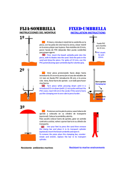
© Copyright 2026