
THE BAGNOLD DUNES AT GALE CRATER – A KEY TO READING
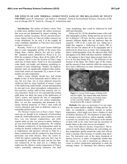
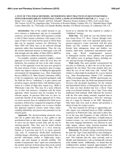
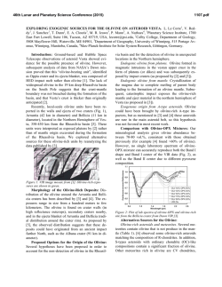
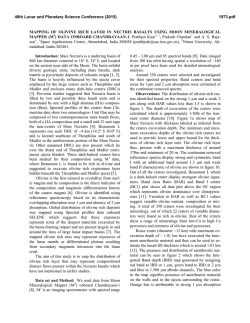
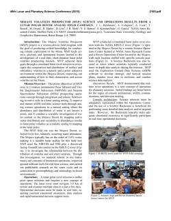
46th Lunar and Planetary Science Conference (2015)
1634.pdf
THE BAGNOLD DUNES AT GALE CRATER – A KEY TO READING THE GEOLOGIC RECORD OF
MOUNT SHARP. M.G.A. Lapotre1, B.L. Ehlmann1,2, F. Ayoub1, S.E. Minson3, N.T. Bridges4, A.A. Fraeman1, R.E. Arvidson5, J.L. Eigenbrode6, R.C. Ewing7, J.R. Johnson4. 1California Institute of Technology, Pasadena, CA, USA. 2Jet Propulsion
Laboratory, Pasadena, CA, USA. 3USGS, Menlo Park, CA, USA. 4John Hopkins University, Laurel, MD, USA. 5Washington
University in St. Louis, MO, USA. 6NASA/GSFC, Greenbelt, MD, USA. 7Texas A&M University, College Station, TX, USA.
Introduction: The Curiosity rover is currently investigating the Pahrump Hills outcrop, which forms the basal part
of the Murray formation at the base of Mt. Sharp. The Murray formation is exposed in cross-section for several
kilometers, and at the center of this broad expanse of bedrock
lays the informally named Bagnold dune field. A careful
analysis of the chemical and mineralogic composition of the
sands is important to interpreting the geologic record ahead,
as the active sands may be the best protolith analog to the
wind-blown sandstones the rover will encounter. Milliken et
al. (2014) suggested that the lower stratigraphy of Mount
Sharp is draped by aeolian sandstones, likely cemented by
sulfates and/or clays, having preserved bedforms in places.
Moreover, the basal units of Mount Sharp may also contain
wind-blown sandstones, as indicated by exposed stratigraphy
in a canyon of western Mount Sharp [1]. A key to understanding the past aqueous history of Gale Crater is to characterize the cementing phases, and in particular to discriminate
between detrital and authigenic minerals. In the absence of
thin sections, this question can only be answered if the composition of the protolith is well known. For example, the
presence of clay aggregates in the dune-forming material
would strongly argue against an authigenic origin.
Orbital observations at Gale crater show that the dune field is
active [2], and that olivine and/or pyroxene signatures are not
homogeneously distributed in the Bagnold dune field [3]
(Figure 1). Further visible and near-infrared orbital observations confirm that Martian winds sort mineral phases as they
do on Earth [4-5], and we thus do not expect previously analyzed non-active sands (e.g., [6]) to be representative of the
Bagnold dune field. A quantitative understanding of mineral
sorting in the Bagnold dunes is thus critical for the interpretation of future CheMin, APXS, and other rover compositional
datasets (e.g., SAM).
Figure 1: (A) Olivine and high calcium pyroxene composite
parameter map over barchans (B) and barchanoid ridges (C).
This figure is from [3]. Note that longitudinal dunes are not
observed in this scene but are observed further to the south
west of the dune field.
Hypothesis: The Bagnold dunes are a complex field,
with both barchanoidal and longitudinal sections. Because of
their different geometries and orientations with respect to
transport direction, spatial grain sorting is expected to be
different on barchan and longitudinal dunes (e.g., [7-9]).
Barchan dunes generally have coarser material at the toe of
the windward face. The lee face of barchan dunes is made of
the material that mostly saltates (with some reptation and
creep contributions) up the dune and then avalanches from
the crest, and is thus made of the same, generally finer material as the bulk of the bedform. Longitudinal dunes have their
slip faces alternating from one side to another, leading to
approximately symmetrical grading, where grain size varies
inversely with elevation on the dune: coarser material avalanches to the toe on either side and is remobilized again
only by the strongest winds, while finer material saltates to
the crest. Grain sizes at the crest of longitudinal dunes tend to
be much more narrowly distributed than those at the crest of
barchans [7]. Seelos et al. (2014) have observed an enrichment in olivine in barchan dunes, whereas barchanoid ridges
seem to grade from pyroxene-rich at the toe of their windward face to olivine-rich towards their crests [3] (Figure 1).
A possible explanation is that wind feels the roughness of the
dune field at the upwind margin and slows as it moves towards Mount Sharp. Consequently, the barchans may concentrate coarser material because winds are capable of transporting the coarse grains there, but not further downwind,
closer to the mound.
In summary: (1) We expect the degree and patterns of
mineral sorting to differ between barchan and longitudinal
dunes of the Bagnold dune field, and (2) we expect
coarser/denser grains to be found at lower elevations. The
latter implies that mineral sorting and consequent chemical
variations can be used as a tool to infer whether crossstratifications within Mount Sharp, which may represent
preserved slip faces, are remnants of barchans or longitudinal
dunes, and thus provide insights on paleo-wind directions,
sedimentary transport, and mineralogic sorting.
Methods: The scope of our work is three-fold.
(1) We compare sand displacement maps derived from correlation of HiRISE images to mineral parameter maps derived
from CRISM observations over the Bagnold dunes where
Curiosity is expected to traverse in order to better identify
endmember targets for the rover (Figure 2). (2) We make
predictions of the modal mineralogy and grain sizes at the
proposed target locations using Hapke’s bidirectional reflectance model [10] on DISORT atmospherically corrected
CRISM data using approaches outlined in [11], combined
with a Markov-Chain Monte Carlo (MCMC) algorithm [12]
that allows us to map uncertainties of the inverted compositions. Finally, (3) we will test our predictions from orbital
datasets with potential CheMin and APXS measurements
once the Curiosity rover reaches the dune materials.
Initial Results:
Displacement-Spectral Properties Relationships: Initial observations over the barchanoidal portions of the dune field
showed that sands that exhibit larger reptation fluxes (the
portion of the flux contributing solely to ripple migration)
also has more positive spectral continuum slopes from 0.7-
46th Lunar and Planetary Science Conference (2015)
1634.pdf
expected traverse path are more complex, possibily dictated
by the longitudinal morphologies in this location. For example, Figure 2 shows that in the aforementioned area, spectral
continuum slope seems to be anticorrelated with reptation
flux. This might reflect the effect of the olivine and/or pyroxene absorption bands on the continuum slope rather than
that of a dust layer. Analyses are ongoing.
Modal Mineralogies: Initial modeling of spectra from a large
region of interest within the barchanoidal portion of the dune
field [5] showed models roughly in accord with sand compositions measured by Curiosity. Modeled compositions were
roughly 5 wt% olivine, 45 wt% pyroxenes, <0.5 wt% magnetite, and the remaining 50 wt% was either labradorite or a
mixture of labradorite and an amorphous phase. Results were
strongly influenced by whether or not amorphous basaltic
glass was included, driving a new modeling approach that
rigorously quantifies statistical probabilities of fits. Initial
testing of the MCMC algorithm for basaltic compositions
shows that the abundance uncertainty of a given mineral
endmember is greater when its actual abundance is low, and
can be as high as ±25 wt%.
Future Work: Planning is underway for an in situ campaign at the Bagnold dunes to test these hypotheses and understand the role of aeolian transport in creating mineralogically and chemically distinctive sands. We expect the rover
to measure compositional differences between at least two
well-chosen targets in the Bagnold dune field. Combining
CheMin and APXS data will allow us to discriminate between crystalline and amorphous phases, whereas SAM will
allow us to analyze the least abundant phases as well as the
coarser fraction of the sands (150 µm to 1 mm). ChemCam,
with a LIBS spot size of less than 0.5 mm [13-14], should
have the ability to measure the elemental composition of
individual grains. Along with the other compositional
datasets and images, such data will quantitatively constrain
the degree of physical sorting that is attained under modern
wind conditions, and thus provide a framework to interpret
potential compositional trends in the stratigraphy ahead, as
well as more generally, will inform our understanding of
sandstones on the planet overall. Moreover, the Bagnold
dune field campaign will be the first in situ investigation of
any active dunes on another planet.
Figure 2: (A) Sand displacements as derived from correlation of HiRISE images of ripples using COSI-Corr. The derived displacements thus correspond to grains moving in
reptation only. (B) Spectral contiunnum slope derived from
CRISM, DISORT-corrected data. Note that displacement and
continuum slope tend to be anticorrelated. The white line
represents the planned rover traverse.
2.5 µm [5]. We interpreted this trend as the effect of a bright
dust layer covering the overall dark, mafic sands in areas
where reptation fluxes are low. Dust cover enhanced the
spectral reflectance most strongly in the near-infrared shortward of ~1 µm, thus resulting in negative continuum slopes
for dusty bedforms. Note that corrosion of olivine might
lead to similar observations from orbit, and the rover will be
able to test this hypothesis through chemical analysis and
imaging. However, subsequent analyses of orbital data over
the portion of the Bagnold dune field closest to Curiosity’s
References: [1] Milliken R. E. et al. (2014) GRL, 41-4,
1149–1154. [2] Silvestro, S. et al. (2013), Geology, 41, 483486. [3] Seelos K. D. et al. (2014) GRL, 41-14, 4880-4887.
[4] Bridges N. T. et al. (2014), GSA Annual Meeting, Abstract #202-12. [5] Lapotre M. G. A. et al. (2014), 8th Conference on Mars, Abstract #1126. [6] Blake D. F. et al. (2013),
Science, 341-6153. [7] Bagnold R. A. (1941). [8] Howard A.
D. (1977), GSA Bulletin., 88. [9] Kok J. F. (2012), Rep.
Prog. Phys., 75. [10] Hapke B. (1981), JGR, 86-B4, 30393054. [11] Arvidson R. E. et al. (2014), Science, 343, doi:
10.1126/science.1248097 [12] Minson S. E. et al. (2013),
Geophys. J. Int., 194-3, 1701-1726. [13] Maurice, S. et al.
(2012), Space Sci. Rev., 170, 95-166. [14] Wiens, R.C. et al.
(2012), Space Sci. Rev., 95-166, 170, 167–227.

© Copyright 2026