
MOJAVE VOLATILES PROSPECTOR (MVP): SCIENCE AND
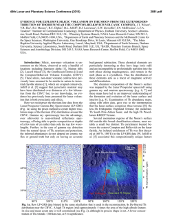
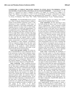
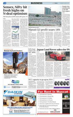
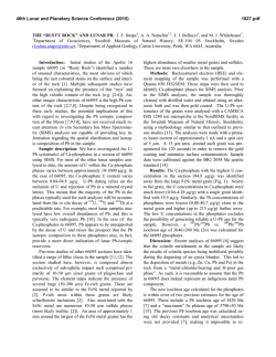
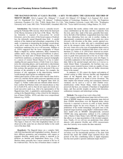
46th Lunar and Planetary Science Conference (2015)
2165.pdf
MOJAVE VOLATILES PROSPECTOR (MVP): SCIENCE AND OPERATIONS RESULTS FROM A
LUNAR POLAR ROVER ANALOG FIELD CAMPAIGN. J. L. Heldmann1, A. Colaprete1, A. Cook1, T.
Roush1, M. Deans1, R. Elphic1, D. Lim1, J. R. Skok1, N. E. Button2, S. Karunatillake2, G. Garcia1 1NASA Ames Research Center, Moffett Field, CA 94035 ([email protected]), 2Louisiana State University, Geology and
Geophysics Department, Baton Rouge, LA 70803
Introduction: The Mojave Volatiles Prospector
(MVP) project is a science-driven field program with
the goal of producing critical knowledge for conducting robotic exploration of the Moon. MVP feeds science, payload, and operational lessons learned to the
development of a real-time, short-duration lunar polar
volatiles prospecting mission. MVP achieved these
goals through a simulated lunar rover mission to investigate the composition and distribution of surface and
subsurface volatiles in a natural and a priori unknown
environment within the Mojave Desert, improving our
understanding of how to find, characterize, and access
volatiles on the Moon.
Mission Overview: The prime objectives of MVP
were to 1) mature instruments (Near Infrared and Visible Spectrometer Subsystem (NIRVSS) and Neutron
Spectrometer Subsystem (NSS)) prospecting operations concept through integration and robotic field testing in native soils in a lunar analog setting, 2) improve
and mature xGDS real-time science tools through analog science operations in a natural setting where the
abundance and distribution of water is not known a
priori, and 3) conduct a scientific investigation of water content in the Mojave Desert by mapping native
water distribution and variability in abundances similar
to lunar polar volatiles as a realistic analog to mapping
at the lunar poles.
The MVP field site was the Mojave Desert, selected for its low, naturally occurring water abundance.
The Mojave typically has on the order of 2-6% water,
making it a suitable lunar analog for this field test.
MVP used the NIRVSS and NSS plus a downward
facing GroundCam camera on the KREX-2 rover (Figure 1) to investigate the relationship between the distribution of volatiles and soil crust variation. Through
this investigation, we matured robotic in situ instruments and concepts of instrument operations, improved
ground software tools for real time science, and carried
out publishable research on the water cycle and its
connection to geomorphology and mineralogy in desert
environments.
Operations: A lunar polar rover mission is unlike
prior space missions and requires a new concept of
operations. The lunar rover must navigate 3-5 km of
terrain and examine multiple sites in a just a few days.
Operational decisions must be made in real time, requiring constant situational awareness, data analysis
and rapid turnaround decision support tools.
MVP conducted a simulated lunar polar rover mission with the NASA KREX-2 rover (Figure 1) operated in the Mojave Desert by a remote Science Operations Center located at NASA Ames Research Center
and a Rover Operations Center located in the Mojave,
with each location staffed with specific console positions (Figure 2). A Science Backroom was also located at Ames where scientists typically conducted
more in-depth data analysis during the mission. MVP
used the Exploration Ground Data Systems (xGDS)
software to develop strategic and tactical mission
plans, monitor rover data in real-time, and conduct
science data analysis.
Operations Results. MVP demonstrated that realtime rover operations is a new concept of operations
for planetary missions. Initial findings are listed below
for the topics of console architecture, xGDS, communications, and decision making.
Console architecture: Science interests must be
adequately represented within the Operations Center,
and the use of a Science Backroom is beneficial for
performing more detailed data analysis and/or targeted
tasks. However, the Backroom typically lacks adequate situational awareness to significantly participate
in real-time operational decisions.
Figure 1. K-REX2 rover used for MVP field campaign.
Figure 2. Science (top) and Rover (bottom) Operations Centers for MVP.
46th Lunar and Planetary Science Conference (2015)
xGDS: Real-time rover data monitoring by the
Science Team to inform real-time decision making
requires specialized ground data systems, and the capabilities of xGDS were critical for enabling this mission architecture. The Science Team needs a real-time
ability to respond to science data (e.g., update traverse
plans, modify rover activities, etc.), and archived rover
data is necessary for Science follow-up to test hypotheses, revisit sites, and inform operations.
Communications:
Communications
protocols
within the operations architecture are required to facilitate real-time decision making. Also, Science must be
in direct communication with rover navigation and
rover driver teams to enable efficient real-time operations.
Decision making: Flexibility must remain within
the daily operations plans to react to unexpected/interesting data and/or situations as warranted.
Science must also have operational decision making
authority. A priori criteria should be established to
guide real-time operations, but Science also must have
authority to deviate from nominal plan based on situational awareness and experience gained during the
mission.
Science. The science goal of MVP was to understand the water emplacement, distribution, and retention within the Mojave Desert. Previous work [1, 2]
has suggested that the Mojave subsurface water distribution is related to the surface clast cover. For MVP
we therefore mapped out the various surface types
(considering rock size distribution and coverage) based
on the rover imagery, and analyzed the NIRVSS and
NSS prospecting data to determine native water abundances. We also collected surface and subsurface
samples from each terrain type for additional laboratory analysis. In addition, we conducted a water drop
experiment where a known volume of water was systematically introduced over a 1 m2 patch of ground
within each terrain type. Rover data and samples were
collected prior to the water drop and for several days
thereafter to obtain a time profile of water migration.
Four distinct terrain types were identified from the
MVP data. Terrain 1 is a low albedo desert pavement
with small rocks and <65% clast cover. Terrain 2 is a
high albedo wash terrain with few rocks and small
pebble sizes. Terrain 3 is a wash deposit with scattered
rock / cobble cover and Terrain 4 is similar to Terrain
1 but with higher albedo.
To determine native water content, returned samples were baked at 100C for 114 hours to release any
unbound water. Each terrain type had a native water
abundance of 2-3 weight % water. Initial XRD analysis indicates that soil composition includes primarily
quartz, albite (sodium plagioclase feldspar), and illite
(phyllosilicate).
2165.pdf
Visible-near infrared lab spectra are shown in Figure 3. The baseline data are for native Mojave soil
while the “T+0.3 hr” data are for soils 0.3 hours after
the water drop experiment. In these data, the 1900 nm
band deepens, indicating the presence of more water,
as expected. We have quantitatively analyzed the 1900
nm band depth for the water drop samples over each
terrain as a function of time. We find that 1) the band
depth systematically increases post-water drop, 2) the
largest band depth increases are seen in upper 1-10 cm
in the subsurface, 3) band depths decrease as the soil
dries over 28 hours (drying curve) 4) band depths are
lowest (and relatively constant) after soils were baked
> 24 hrs, indicating water has been released, and 5)
there are negligible changes in band depths at soil
depths of 10-20 cm.
Figure 3. VIS-NIR spectra of Mojave soils. “Baseline”
indicates native Mojave samples and “T+0.3hr” indicates data collected from samples 0.3 hours post-water
drop.
Based on these datasets, we suggest that the Mojave soil water abundances are comparable to the expected abundances of lunar south pole cold traps (~2-3
wt %). Water in the Mojave does not penetrate beneath the upper ~10 cm of water (based on the band
depths data and the measured water weight percentages) as infiltration is prevented via absorption by the
soil materials. This interpretation is supported by the
initial XRD analysis suggesting the presence of clays,
which are efficient at absorbing water. Samples from
10-20 cm depths generally have lower native water
abundances than 1-10 cm depths and do not show increases in water abundance with water drop experiment. In addition, Terrain 3 had the largest change in
band depth after the water drop experiment, suggesting
the rocky wash terrains have highest water retention
potential.
References: [1] Wood, Y. A. et al. (2002) J. Arid
Enviro., 52, 305-317. [2] Wood, Y. A. et al. (2005)
Catena, 59, 205-230.
Acknowledgments: The authors would like to
thank the MVP Science, Operations, and Assessment
teams. Special thanks to Janice Bishop and Adrian
Brown (SETI Institute) for use of the SETI Soils Lab
& UV-VIS ASD Spectrometer. We also appreciate the
support of David Blake and Tom Bristow (NASA
Ames) for use of the XRD instrument.


© Copyright 2026