
A TEST OF TWO FIELD METHODS: DETERMINING BEST
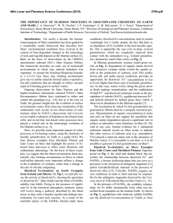
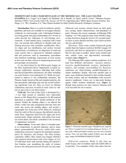
46th Lunar and Planetary Science Conference (2015)
1640.pdf
A TEST OF TWO FIELD METHODS: DETERMINING BEST PRACTICES IN RECONNOITERING
SITES FOR HABITABILITY POTENTIAL USING A SEMI-AUTONOMOUS ROVER. R.A. Yingst1, J.A.
Berger2, B.A. Cohen3, B.M. Hynek4, and M.E. Schmidt4; 1Planetary Science Institute (1700 E. Fort Lowell, Suite
106, Tucson, AZ 85719; [email protected]), 2University of Western Ontario, London, ON, CA, 3Marshall Space Flight
Center, Huntsville, AL; 4University of Colorado-Boulder, Boulder, CO.5Brock University, St. Catharines, ON, CA.
Introduction: One of the central tensions in any
rover mission is deployment and use of consumable
resources. Given that the Mars 2020 payload is similar
to that of Mars Science Laboratory with respect to the
types of data it will yield and the speed at which those
data can be acquired, resource use efficiencies for
Mars 2020 will likely have to be achieved through
operation rather than instrumentation. Thus, the way
the science backroom chooses to interrogate a site will
feed strongly into the ability of Mars 2020 to fulfill its
science objectives within the mission lifetime.
For example, scientists commonly employ a linear
approach in rover fieldwork, where the rover does not
backtrack, but examines all sites in the order encountered. As this approach covers the most new ground in
the least amount of time, it maximizes data coverage,
which may improve chances of finding the appropriate
environment for biosignatures (e.g., Mars Exploration
Rovers (MER) [1-2], Mars Science Laboratory (MSL)
[3-4]). In comparison, most terrestrial geologists walk
the field site first (a “walkabout”), to gain context and
prioritize targets, and then follow with detailed examination of a subset of high-value targets (e.g., MER at
Whitewater Lake [5]). This may be a more efficient
use of time and resources, compared with the linear
approach, where resources may be overspent on less
relevant targets. In previous field tests we have assessed the benefits of the linear approach [6-7]. Here,
we used a nascent form of walkabout-first field reconnaissance, followed by a targeted investigation of highpriority locations. Our purpose was to assess whether
this approach improves science return where understanding habitability and preservation potential are the
mission goals.
Approach: The decision-making protocols scientists use to gather data (drive or stay; gather in situ
geochemical data or take more images; take a sample
or move on) are based on prior data, and are not instrument-specific. Thus, they may be tested without
using flight-ready instruments or a rover mock-up.
Instead, as in previous tests [6-7], we used a generalized suite of commercial off-the-shelf instruments
yielding images, mineralogy, and geochemical data, to
provide information similar to flight-ready instruments, and used humans to provide mobility. The
number of operational “days” spent was constrained by
the number and type of observations that can be carried
out in a typical operational “day” on Mars. This al-
lowed us to calculate the time required to conduct a
“walkabout” strategy.
Field Site: Our field site was San Rafael Swell,
near Green River, UT. Here, Triassic through Cretaceous sedimentary units were deposited during transgressive-regressive events associated with the great
inland sea. This resulted in intermingled deposits
formed from subaqueous (deep and shallow carbonates, shale units, sandstones) and subaerial (sandstone
ergs,
fluvial
conglomerates)
processes. Subsequent tectonic forces uplifted and exposed
~100 million years of geologic history, including micro- and macroscopic biosignatures [8-9].
Field work: One team member reconnoitered the
site prior to fieldwork, to allow the rest of the team to
approach the site blind. This team member then provided the rest of the field team with “orbital” data
similar to what might be produced for a rover mission
(e.g., Mars Reconnaissance Orbiter CTX resolution
visible-wavelength images, CRISM spectroscopic images). Using these data, the field team planned notional
traverses and developed hypotheses for the location
and depositional history of biologically relevant units.
The team was then divided into two: a Rover Team
using rover-limited methods, and a Tiger Team using
traditional field methods. Both followed the traverse,
with the first team taking remotely acquired data at
each traverse stop (mimicking a “drive-by” interrogation of a target by Pancam or the MSL Mastcams).
Only these data were used to choose and prioritize a
subset of stops for contact science.
The time required for driving or approaching specific targets was estimated based on MER walkabout
experience at Whitewater Lake, and used to place limits on the type and frequency of data collected. For
example, based on MER experience, in-depth analysis
(contact science, e.g., use of contact geochemical and
fine-scale imaging instruments) was allowed on only
eight targets, chosen using remotely-acquired data
gathered on the first pass through the traverse.
Discussion: We found a strong correlation between
the units the Tiger Team identified as most biologically relevant, and those the Rover Team identified as
such. This indicates that the clues currently used to
identify and characterize a site as biologically relevant
yield reliable results. Additionally, we found that the
walkabout-first method required approximately 25%
more time to execute, compared with a more tradition-
46th Lunar and Planetary Science Conference (2015)
al linear approach to the rover traverse path. However,
the team members were unanimous in their judgment
that, had the linear reconnaissance approach been executed, the team would never have found the most biologically-rich samples. Instead, they would have spent
significant time and resources attempting to characterize a unit that appeared biologically-relevant (an orbital phyllosilicate/carbonate signature), simply because it was earlier on the traverse. Time would have
run out before the team reached the best locations.
Future work: We intend to focus future work on
testing these two approaches for situations where sample cache or return is the goal. For example, would the
walkabout-first approach increase scientific consensus
regarding choice of sample selection, as it did when
doing simple reconnaissance, or would the additional
information result in greater dissonance among the
science backroom because of differing interpretations?
Would the same targets be seen as optimal by either
approach? Understanding the trade space between improving science return and time/mileage expended
1640.pdf
when making science-based decisions allows the most
efficient use of funding and time, and will have a significant impact on where future resource allocations
must be focused for such missions.
References: [1] Arvidson, R.E. et al. (2007), LPSC
38th, Abs. #1122.. [2] Grotzinger, J.P. et al. (2005),
Earth Planet. Sci. Lett., 240, 11-72. [3] Grotzinger,
J.P.,
et
al.
(2014),
Science,
343,
doi:
10.1126/science.1242777. [4] Stack, K. et al., this volume. [5] Arvidson, R.E., et al. (2014), Science, 343,
doi:10.1126/science.1248097. [6] Yingst, R.A., et al.
(2011), Mars, 6, 13-31, doi:10.1555/mars.2011.0002.
[7] Yingst, R.A., et al. (2014), Acta Astronaut., doi:
10.1016/j.actaastro.2014.01.019. [8] Goodspeed, T.H.,
and S.G. Lucas (2007), Triassic of the American West,
Lucas, S.G. and Spielmann, J.A., eds., NM Museum of
Natural History and Science Bulletin 40. [9] Lucas,
S.G. et al. (2007), Triassic of the American West, Lucas, S.G. and Spielmann, J.A., eds., NM Museum of
Natural History and Science Bulletin 40.
Figure 1. Data and notional traverses for San Rafael Swell, UT. (a) Color blend of Landsat 7 TM spectral and
USGS orthorectified images (similar to MRO data); yellow box encloses area in (b,c). (b) 2 m/pxl Digital Elevation
Model. (c) Notional traverses. Red line = first walkabout traverse; red squares = traverse stops. Blue line = second
walkabout; blue squares = traverse stops. Traverse stops (d) and (e) were chosen because of their strong phyllosilicate/carbonate signature. (d) Remote image from walkabout showing the phyllosilicate signature is due to a veneer
of non-biologically relevant clays. (e) Remote image from walkabout showing embedded fossils. Traverse stop (d)
was dropped in favor of (e) for contact science.
© Copyright 2026