
Remnant Buried Ice in the Arsia Mons Fan
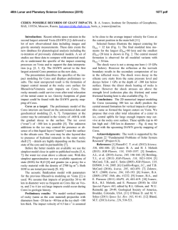
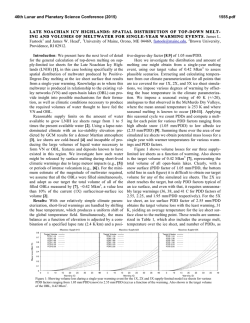
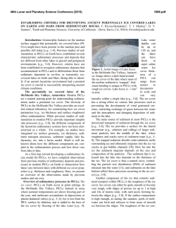
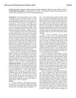
46th Lunar and Planetary Science Conference (2015)
2266.pdf
REMNANT BURIED ICE IN THE ARSIA MONS FAN-SHAPED DEPOSIT, MARS. K. E. Scanlon,1 J. W.
Head,1 and D. R. Marchant.2 1Brown University Department of Earth, Environmental and Planetary Sciences, Providence, RI. 2Boston University Department of Earth & Environment, Boston, MA. [email protected]
Introduction. The western and northwestern flanks
of the Tharsis Montes volcanoes were covered by tropical mountain glaciers 125–220 million years ago [1], as
evidenced by the morphology, stratigraphic relationships, and spatial distribution of landforms in the fanshaped deposits (FSDs) on each volcano [2-8] and by
climate and glacial flow models that predict snow accumulation and ice flow in those regions during periods
of high spin-axis obliquity [9-10]. The ~166,000 km2
Arsia Mons FSD [4,7,8] is the largest of the Tharsis
Montes FSDs and has been in place for ~210 Ma [1].
The Smooth Facies, one of the geomorphologic
units in the FSDs [11-12], has been interpreted as remnant debris-covered glaciers [4]. Shean et al. [5] suggest
that lineated debris partially filling tectonic graben in
the FSD also has ice at its core. The topography of these deposits [5], morphologic indicators of active flow
[4] and the morphology of superimposed craters [13],
suggest that ice 100-300 m thick may still be present at
depth. Here, we review several other classes of landforms in the FSD that have not been previously described, and whose morphology indicates that they may
still contain remnant tropical mountain glacier ice.
Landforms Interpreted as Indicative of Remnant
Ice. On Earth, glacier ice may be buried and preserved
wherever overlying debris is sufficiently thick. The
morphology of several landforms in the Arsia Mons
FSD suggests that ancient ice is present in the FSD:
Pit-and-knob terrain. Near the northern edge of the
fan-shaped deposit is a field of mounds (“knobs”) and
shallow topographic depressions (“pits”; Figure 1). Pits
and knobs are similar in diameter (up to 1 km) and
shape, and generally fall along lines concentric with the
outline of the smooth facies. Many knobs are surrounded by shallow annular depressions (“moats”), and some
pits have what appear to be degraded knobs at their
centers. We propose that the terrain is ice-cored and
that the landforms represent a progression in which
gradual loss of ice via sublimation causes topographic
inversion, with knobs becoming moated knobs, then
pits with degraded knobs, and finally pits.
The Arsia FSD pit-and-knob terrain may have
formed by backwasting of smooth facies ice and subsequent burial of isolated ice blocks by volcanic or aeolian debris, analogous to the formation of terrestrial
kettled outwash plains [e.g. 14-15]. Alternatively, the
pit-and-knob terrain may have formed in a manner
analogous to terrestrial “controlled moraine” [e.g. 1617]. When debris within or atop glaciers [e.g. 18] is
concentrated into belts by glacial flow, bands of debris
Figure 1. CTX mosaic (top) and sketch map (bottom) of typical pit
(yellow in sketch map) and knob (red in sketch map) terrain.
Figure 2. Topographic inversion model for the formation
of the pit-and-knob terrain.
46th Lunar and Planetary Science Conference (2015)
can isolate patches of ice as the glacier retreats. As sublimation or melt proceeds, these ice bodies form linear
arrangements of mounds and kettle holes, becoming
less continuous and linear as ice removal continues. We
favor this “controlled moraine” model (Figure 2) because it accounts for the linear arrangement of the pits
and knobs without requiring widespread accumulation
of ice blocks to have occurred at the ice margins.
Drop moraines with linear troughs. At the northwestern edge of the FSD, some Ridged Facies drop
moraines [4] have linear crest troughs. These moraines
are ~100 m wide and continuous for ~100 km or more.
Other nearby moraines are similar in size and shape but
lack crest troughs. We interpret these troughs to have
formed by the loss of ice. On Earth, ice-cored moraines
can develop at glacier margins when bands of englacial
debris isolate masses of ice from the main body as a
glacier retreats [e.g. 16]. This is further supported by
the lone subaerial lava flow in the Ridged Facies,
whose chaotic texture is interpreted to have resulted
from interactions between the lava flow and ice in the
moraines at the time of flow emplacement [7].
Postglacial Ice-Related Landforms. Throughout
the northwestern edge and surroundings of the FSD are
short (~2-9 km) elongate ridges with axial troughs. In
contrast to the drop moraines with similar troughs, their
distribution is not restricted to any one unit of the FSD,
they are always oriented southwest-to-northeast, and
they are straight rather than curved in plan view. They
are also continuous over much shorter distances than
the moraines, and are often concentrated in local topographic lows. In general, they appear dune-like, but
have a characteristic trough along their crest.
We suggest that this morphology results from the
sublimation of ice along the crests of ice-rich dunes.
Pedestal craters dated to 12–13 Ma and found throughout Tharsis [19] suggest that several meters of ice covered the region very recently. Due to the superposition
of the dunes upon the other units of the FSD, we propose that deposits such as this later ice cover may have
been the source of the ice that formed the dunes with
linear troughs. The greater density of dunes within the
FSD suggests that the dunes may also have been built
by reworking of ice and debris from the FSD itself.
These ridges may have formed as mixed snow-ice
dunes. When spin-axis obliquity lowered to the point
that ice was no longer stable at the equator [e.g. 20],
sublimation of the snow would have concentrated the
dust component in the outermost layers. If the sides of
the dunes were sufficiently steep, these dry outer layers
would have slumped down the ridge sides, forming
debris piles at either side and exposing more ice to sublimation. A similar process creates “circular moraine
features” from debris-covered ice blocks on Earth [21].
2266.pdf
Alternatively, the ridges could have formed as snow
dunes that were later covered by a layer of dust or tephra. Because the least compressive stress in a ridge is
oriented horizontally away from the axis of the ridge
[e.g. 22-23], long tensile cracks aligned with the dune
crests could be expected to form in the sediment cover.
Similar fractures form at the crests of debris-covered
snow ripples in the Antarctic Dry Valleys and on niveoaeolian dunes and beds in Alaska as their snow component melts [24]. Fractures in the protective dust cover
would enhance sublimation directly beneath them by
exposing the underlying snow [25-26], enlarging the
hollow along the ridge axis. Based on the similarity of
these features to terrestrial debris-covered snow dunes,
and because plausible heights for the ripples are lower
than those of ice blocks that form circular moraine features on Earth, we favor the second mechanism.
Conclusions. The geomorphology of three landform
classes in the Arsia Mons FSD suggests that the deposit
contains more remnant ice than previously thought. In
addition to evidence that ice has been removed from
some but not all of the glacial moraines in the deposit,
and that volcanic flows to the northwest of the deposit
interacted with ice-cored moraines, there is morphological evidence that knobs near the northern edge of the
FSD contain debris-armored ice. Fields of dunes with
linear troughs along their crests suggest that windblown
snow was widespread across the region in the Amazonian and may be preserved under debris in some locations. The knobs and moraines are a potential reservoir
of buried, present-day equatorial ice, in addition to the
ice previously estimated [5, 13] to remain in the
Smooth Facies, further enhancing the Arsia Mons FSD
as a potential target for future exploration missions.
References. [1] Kadish S. J. et al. (2014) PSS, 91, 52-59. [2] Williams R. (1978) Geol. Soc. Am. Abst. with Programs, 10, 517. [3]
Lucchitta B. K. (1981) Icarus, 45(2), 264-303. [4] Head J. W. and
Marchant D. R. (2003) Geology, 31(7), 641-644. [5] Shean D. E. et
al. (2007) JGR:Planets, 112(E3). [6] Kadish S. J. et al. (2008) Icarus,
197(1), 84-109. [7] Scanlon K. E. et al. (2014) Icarus, 237, 315–339.
[8] Scanlon K. E. et al. (2015) Icarus, 250, 18-31. [9] Forget F. et al.
(2006) Science, 311(5759), 368-371. [10] Fastook J. L. et al. (2008)
Icarus, 198(2), 305-317. [11] Zimbelman J. R. and Edgett K. S.
(1992) LPSC XXII, p. 31-44. [12] Scott D. and Zimbelman J. (1995)
USGS Misc. Geol. Investigation Map I-2480. [13] Head J. W. and
Weiss D. K. (2014) PSS, 103, 331-338. [14] Evans D. J. A. (2011)
Geomorphology, 129, 225–237. [15] Knight J. (2012) P. Geologist.
Assoc., 123, 714–727. [16] Evans D. J. A. (2009) Quat. Sci. Rev.,
28(3-4), 183–208. [17] Bennett G. L. and Evans D. J. A. (2012) Earth
Surf. Processes, 37, 1584–1602. [18] Mackay S.L. et al. (2014) JGR:
Earth Surface, 119, 2505–2540. [19] Schon S. C. and Head J. W.
(2012) EPSL, 317-318, 68-75. [20] Jakosky B. M. and Carr M. H.
(1985) Nature, 315(6020), 559-561. [21] Ebert K. and Kleman J.
(2004) Geomorphology, 62(3-4), 159–168. [22] Rubin D. M. and
Rubin A. M. (2013) Geol. Soc. Am. Bull., 125, 1943–1946. [23] Fiske
R. S. and Jackson E. D. (1972) P. Roy. Soc. Lond. A., 329, 299–326.
[24] Koster E. A. and J. W. A. Dijkmans (1988) Earth Surf. Processes, 13, 153–170. [25] Mangold N. (2003) JGR:Planets, 108(E4). [26]
Mangold N. (2011) Geomorphology, 126(1), 1-17.


© Copyright 2026