
Establishing Criteria for Identifying Ancient Perennially Ice Covered
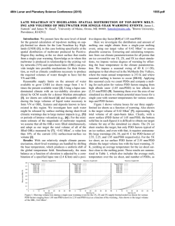
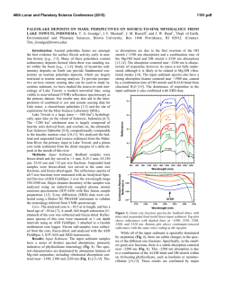
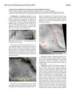
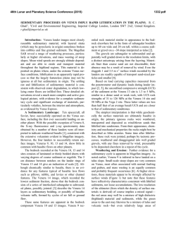
46th Lunar and Planetary Science Conference (2015)
1686.pdf
ESTABLISHING CRITERIA FOR IDENTIFYING ANCIENT PERENNIALLY ICE COVERED LAKES
ON EARTH AND MARS FROM SEDIMENTARY ROCKS. F. Rivera-Hernández1, T. J. Mackey1, D. Y.
Sumner1, 1Earth and Planetary Sciences, University of California – Davis, Davis, CA, 95616; [email protected]
Introduction: Geomorphic features on the martian
surface suggest that perennially ice covered lakes (PICLs) might have been present in the martian past and
possibly still today [e.g., 1-4]. Previous studies of sedimentation in PICLs on Earth have established several
characteristic sedimentary processes and deposits that
are different from other lakes in glacial and periglacial
environments [e.g., 5-8]. However, criteria have not
been established to recognize sedimentary deposits that
accummulated in PICLs and to differentiate them from
sediments deposited in ice-free or transiently icecovered lakes on Earth and Mars. Being able to identify if an ancient lacustrine environment had a perenial
ice cover is crucial to successfully interpreting ancient
climate conditions.
The perennially ice covered lakes of the
McMurdo Dry Valleys, Antarctica: Modern PICLs
are a natural starting point for understanding sedimentation under a perennial ice cover. The diversity of
PICLs in the McMurdo Dry Valleys provides an excellent natural laboratory for constraining how ice cover
parameters (e.g., ice thickness and surface roughness)
affect sedimentation. While previous studies of sedimentation in modern PICLs provide important insights
into processes [e.g., 5-8], the different components of
the lacustrine sedimentary systems have not been characterized as a whole. For example, no studies have
integrated ice surface geometry, ice thickness, sediment transport processes, sediment supply, lake bathymetry, etc. into a facies model. Much is still unknown about how the different components are coupled in the sedimentation process and how these vary
from lake to lake.
As a first step toward developing a sedimentary facies model for PICLs, we have compiled observations
from previous studies of sedimentary deposits and processes in modern PICLs on Earth to characterize how
these vary between lakes with different ice cover properties (e.g., thickness and roughness). Here, we present
an overview of the observations made by previous
studies and our own.
Overview of sedimentary processes in PICLs: The
ice cover. PICLs on Earth occur in polar settings. In
the McMurdo Dry Valleys, PICLs formed in areas
where summer temperatures are above freezing part of
the year, and meltwater accumulates in depressions or
glacier-dammed valleys [e.g., 5, 6]. Ice is lost from the
PICL surface by ablation, and is added to the base of
the ice cover by freezing of the lake water [e.g., 9].
Lake water
depths can
be up to
120 m, and
the
lakes
can
have
fresh
to
super saline
water. Ice
Figure 1. Aerial image of Lake Joyce
cover thickin the McMurdo Dry Valleys, Antarctiness of a
ca. Image shows a dark band around
can
the ice cover of the lake where most of PICL
range
from
the aeolian sediment is ‘trapped’. Sedto
iment banding is unique to PICLs with meters
2
decameters
rough ice covers. Lake Joyce is ~1 km
in scale and
in area.
can
vary
laterally within a single lake [e.g., 5-8]. The ice cover
has a strong effect on various lake processes such as
preventing the development of wind generated currents, restricting exchange of gases between the water
and the atmosphere and changing deposition of sediment in the lake.
The main source of sediment in most PICLs is the
downward transport of sediment through the ice cover
[e.g., 5-8]. The ice provides a surface for the lateral
movement (e.g., saltation and rolling) of larger sediment particles into the middle of the lake, where
roughness and cracks serve as sediment traps [e.g., 58]. The trapped sediment absorbs solar radiation, melts
surrounding ice and ultimately migrates into the ice via
cracks or gas bubble channels [10]. How far into the
ice the sediment migrates depends on the size and
composition of the particles. The sediment that is released into the lake also depends on the thickness of
the ice. The ice cover is thus a natural sieve, controlling the particle size distribution (PSD) of sediment
released into the water [11], and sediments on the lake
bottom reflect these processes occurring in the ice cover [e.g., 5-8].
Another component of the ice that controls sediment transport within PICLs is the roughness of the ice
cover. Ice covers can either be quite smooth or become
very rough, with ridges of porous ice up to 1 m high
and 10s of meters wide, with melt pools forming between the ridges [e.g., 5-8]. If the surface temperature
is high enough, as during the summer, pools of meltwater can form and refreeze to form areas of smooth
ice between the ridges. The roughness of the ice con-
46th Lunar and Planetary Science Conference (2015)
trols the lateral transport of sediment over the ice and
consequently the distribution and amount of sediment
on the ice cover (Figure 1). In turn, sediment trapped
in the ice increases melting and can increase ice cover
roughness, providing a feedback process. The amount
of sediment transported vertically through the ice and
into the lake depends on both ice roughness and the
initial distribution of sediment on the ice.
Sedimentary deposits. Sedimentation in PICLs has
been previously studied primarily by the use of sediment cores and sediment traps in localized regions
within a lake [e.g., 5-8]. From these studies, it is
known that PICLs with different ice cover thicknesses
are associated with different sedimentary processes
and unique sedimentary structures [e.g., 5-8]. PICLs
with thick ice covers (~ > 3 m) have highly localized
sedimentation, producing ridges and sand mounds
[Figures 2 and 3; e.g., 5-8]. Our observations suggest
that PICLs with thin ice covers (< 1 m) do not appear
to show these characteristic sedimentary deposits, and
instead have more laterally homogenous deposits
across the lake bottom. Sealed PICLs, lakes where the
ice cover extends to the lake bottom, represent another
end-member case. For example, Lake Vida, Antarctica,
has an ice cover that is thought to extend ~ 27 m [e.g.,
12]. In this case, small pockets of sediments and thin
sediment layers up to 20 cm thick are found within the
ice cover, and a liquid-brine exists at the ice bottom
[12]. The ice is interpreted to have formed from surface runoff, and the sediment layers represent the accumulation of fluvial and aeolian deposits on top of ice
[e.g., 12]. What gets preserved from this setting in the
sedimentary record has yet to be constrained.
Implications for Mars: Under present environmental conditions, liquid water is not stable at the surface of Mars. However, abundant evidence for liquid
water early in Mars’ history has been accumulated
from rover, orbiter, and landed missions [e.g., 1-4,1315]. During this interval, there were likely small lakes
similar to the modern PICLs on Earth, for example,
Yellowknife Bay at the toe of the relatively young
Peace Vallis fan could have been ice covered [15]. We
will not know until we have the sedimentary criteria to
identify PICL deposits.
Concluding remarks: In summary, we present an
overview of sedimentary deposits and processes in
modern PICLs on Earth and highlight three-end member cases of sedimentation regimes. These end members are a starting point for investigating the factors
that control sedimentation in PICLs and how these
vary from lake to lake. This is crucial information that
is necessary to develop a generalized sedimentary facies model for PICLs on Earth and other planetary bodies. In the martian past, there were likely small lakes
similar to the modern PICLs on Earth, however until
1686.pdf
we have criteria for identifying PICL deposits in the
sedimentary record, we will not be able to distinguish
between open water and ice-covered lakes.
Figure 2. Sand mound at the bottom of Lake Hoare.
The sand mound is covered by a microbial mat. Variations in the size and shape of sand mounds are thought
be due to lake water depth [5]. The distance between
the two red points is 10 cm.
Figure 3. Sand ridge at the bottom of Lake Hoare.
Sand ridges have been observed to parallel cracks in
the ice cover [5, 7]. The distance between the two red
points is 10 cm.
References: [1] Grin, E. (1997) Icarus, 130, 461-474. [2]
Howard, A. D., and Moore, J. M. (2004) GRL, 31, 1. [3]
Moore, J. M., and Wilhelms, D. E. (2001) Icarus 154, 2, 258276. [4] Fairén, A. G., et al. (2014) Planetary and Space
Science, 93, 101-118. [5] Squyres, S. W., Andersen, D. W.,
Nedell, S. S. & Wharton Jr., R. A. (1991) Sedimentology, 38,
363–379. [6] Schackman, M. A. (1994) M.S. Thesis, San
Jose State. [7] Andersen, D. W., Wharton, R. A., & Squyres,
S. W. (1993) AGU, pp. 71-81. [8] Doran, P. T., Wharton Jr,
R. A., and W. Lyons, B (1994). J. of Paleolimnology, 10, 2,
85-114. [9] McKay, C. P., Clow, G. D., Wharton, R. A., &
Squyres, S. W. (1985) Nature, 561-562. [10] Jepsen, S. M.,
Adams, E. E., & Priscu, J. C. (2010) Arctic, Antarctic, and
Alpine Research, 42, 1, 57-66. [11] Hendy, C. H.
(2000) Geografiska Annaler: Series A, Physical Geography, 82, 2‐3, 271-274. [12] Dugan, H. A. and Doran, P. T.
(2014) The Cryosphere Discussions, 8, 4, 4127-4158. [13]
Carr, M. H., & Head III, J. W. (2010) Earth and Planetary
Science Letters, 294(3), 185-203. [14] Carr, M. H.
(2012) Philosophical Transactions of the Royal Society A:
Mathematical, Physical and Engineering Sciences, 370(1966), 2193-2215. [14] Grotzinger, J. P., et al.
(2014) Science, 34 3(6169), 1242777.


© Copyright 2026