
EAST VALLEY WATER FORUM MANAGEMENT PLAN
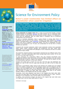
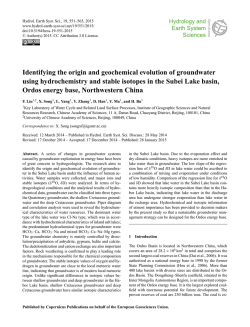
E
EA
AS
ST
TV
VA
ALLLLE
EY
Y
W
WA
AT
TE
ER
R FFO
OR
RU
UM
M
M
MA
AN
NA
AG
GE
EM
ME
EN
NT
TP
PLLA
AN
N
JJuunnee 22000077
TTaab
bllee ooff C
Coon
ntteen
nttss
INTRODUCTION AND BACKGROUND ...............................................................................................................1
MANAGING GROUNDWATER IN THE EAST VALLEY ....................................................................................3
GROUNDWATER MODELING SCENARIO RESULTS......................................................................................4
KEY FINDINGS .........................................................................................................................................................7
RECOMMENDATIONS...........................................................................................................................................10
IMPLEMENTATION................................................................................................................................................13
CONCLUSION and NEXT STEPS ........................................................................................................................13
PLAN APPENDICES:
APPENDIX A – GLOSSARY OF TERMS
APPENDIX B – WATER QUALITY
APPENDIX C – WATER SUPPLIES AVAILABLE IN THE EAST VALLEY
APPENDIX D – INSTITUTIONAL FRAMEWORK IMPACTS
APPENDIX E – INFRASTRUCTURE MAP AND INVENTORY
APPENDIX F – MODEL BUDGETS AND RESULTS
APPENDIX G – AZ DEPARTMENT OF WATER RESOURCES EAST VALLEY WATER FORUM
SCENARIOS FOR THE EAST SALT RIVER SUB-BASIN: AN APPLICATION OF THE
REGIONAL GROUNDWATER FLOW MODEL OF THE SALT RIVER VALLEY, AZ
APPENDIX H – TURF EFFLUENT VALUES
APPENDIX I – PERMITTED RECOVERY WELLS
APPENDIX J – LONG TERM STORAGE CREDITS
APPENDIX K – GROUNDWATER ALLOWANCE BALANCES
APPENDIX L – GRANDFATHERED GROUNDWATER RIGHTS, GENERAL INDUSTRIAL USE
PERMITS, EXEMPT WELLS AND ASSOCIATED WATER WITHDRAWALS IN THE
EAST SALT RIVER VALLEY SUB-BASIN
ADDITIONAL RESOURCES PROVIDED:
ADWR - ASSURED WATER SUPPLY PROGRAM
ADWR – OVERVIEW OF THE GROUNDWATER MANAGEMENT CODE
EEA
AS
PLLA
STT V
AN
N
VA
ALLLLEEY
YW
WA
ATTEER
R FFO
OR
RU
UM
MM
MA
AN
NA
AG
GEEM
MEEN
NTT P
INTRODUCTION AND BACKGROUND
The East Valley Water Forum (“Forum”) was established in 2001 as a voluntary
partnership of water agencies, irrigation districts, and interested stakeholders involved
in water resource management in the East Salt River Valley groundwater sub basin.
Since its inception, the Forum has worked to ensure that groundwater remains a longterm viable source of water. To that end, the Forum members share ideas, identify
common interests, and discuss and explore water infrastructure development and
groundwater resource management strategies. A map showing the planning area
addressed by the Forum is provided in Figure 1. A representative listing of Forum
members is included as Table 1.
Figure 1
East Valley Water Forum Management Plan
June 30, 2007
Page 1 of 14
In early 2003 the Arizona Department of Water Resources (ADWR) awarded the Forum
a grant through the Phoenix Active Management Area Water Management Assistance
Fund to produce an “East Valley Area-Wide Water Management Plan” (Plan).
As stated in the grant, the purpose of
the Plan is to:
“enable water
providers in the East Valley and other
key entities to more effectively plan
for and manage water use in the East
Valley
including
artificial
groundwater recharge, groundwater
pumping and recovery. ADWR and
Table 1
the Forum anticipated the Plan would
”provide a better understanding of water conditions associated with projected
groundwater pumping, and recharge and recovery of surface water and effluent.”
In addition to the ADWR grant, the ADWR Hydrology Division provided staff that
developed models to display groundwater conditions based on Plan scenarios. The
U.S. Bureau of Reclamation (USBR) also contributed significant funding and valuable
staff support.
This document summarizes the results of the long-range planning efforts undertaken by
the Forum. The members of the Forum anticipate this Plan will promote inter-provider
partnerships aimed at developing strategies to effectively manage groundwater. The
Plan also offers recommendations regarding the placement of wells and recharge
facilities to reduce the adverse impacts of regional pumping and to increase the value of
regional recharge.
The appendices include additional water resource information for the East Valley that
may be useful for the Forum’s long-term planning efforts, as well as individual water
providers. In addition, the appendices include the ADWR Modeling Report used to
develop this Plan, and an inventory of existing infrastructure developed by the U.S.
Bureau of Reclamation, that can be used to facilitate exchanges of water, direct
deliveries of water, or other arrangements that may allow water providers to take
advantage of regional economies of scale. A complete listing of appendices is included
in the table of contents.
East Valley Water Forum Management Plan
June 30, 2007
Page 2 of 14
MANAGING GROUNDWATER IN THE EAST VALLEY
To a large degree, the successful and sustainable management of water resources in
Central Arizona (including the East Valley) is contingent upon aquifer management
programs that mitigate:
(1) severe groundwater overdrafts,
(2) groundwater cones of depression, and
(3) groundwater mounding.
Therefore, the Forum’s planning efforts focused on identifying and evaluating the
impacts of three water supply and demand scenarios, under non-drought conditions,
on East Valley groundwater elevations through the use of ADWR’s groundwater
model.
Because the East Salt River Valley Sub-basin is located in a Sonoran desert environment,
native surface water supplies are variable and subject to long-term dry periods. During
shortages of surface water, groundwater is often used by water providers as a
replacement supply. The importance of managing groundwater to ensure its
availability both long term and during drought is the basis of Arizona’s 1980
Groundwater Management Code.
The Code also created the Phoenix Active
Management Area (AMA) as one of five Active Management Areas in the state.
Subsequently, the Phoenix AMA established a primary management goal to attain
“safe-yield” by 2025. Safe-yield is defined as a long-term balance between the annual
amount of groundwater withdrawn in the AMA and the annual amount of natural,
incidental and artificial recharge in the AMA.
Physical and legal access to surface water varies among water providers in the East Salt
River Valley. Some water providers have secured the legal rights and invested
significantly in infrastructure to receive surface water from the Salt, Verde, and
Colorado Rivers. These water providers have also typically developed groundwater
supplies to either augment surface water, or to use as a supplement during drought.
Other water providers are heavily or solely dependent on groundwater to meet water
demands.
All water providers in the East Valley have access to groundwater and are withdrawing
it from the same aquifer (the East Salt River Valley Sub-basin). However, those
providers with limited or no access to surface water are placing a greater strain on the
regional aquifer than those with access to surface water. This strain is particularly acute
in areas of the basin where water withdrawal has been ongoing or near the mountain
fronts.
East Valley Water Forum Management Plan
June 30, 2007
Page 3 of 14
¾ In areas where groundwater is the predominant resource, providers are
withdrawing water at rates that typically exceed the natural and incidental recharge
to the aquifer, which strains the aquifer even in non-drought conditions.
¾ In areas where surface water is the predominant resource, groundwater use in nondrought conditions is minimal, with some net gain to the aquifer due to incidental
recharge from the use of surface water. During drought periods, however, the
overdraft condition is exacerbated when even those water providers who usually
limit their dependence on groundwater are now forced to increase pumping to
supplement limited surface water supplies.
Groundwater is one resource common to all water providers, and because they all
pump from the same basin, management of groundwater use is essential to minimize
effects of over pumping, which impacts all groundwater users to some degree. Forum
members must work collaboratively to achieve sustainable management of regional
groundwater supplies, and to ensure all water providers adhere to the principles of
“safe-yield.”
GROUNDWATER MODELING SCENARIO RESULTS
For the past six years, the East Valley Water Forum members have worked together to
better understand the regional implications of groundwater pumping and recharge in
their area. During this time the Forum has provided information, made assumptions,
and developed scenarios with the goal of developing a hydrologic groundwater model
that will help form a sustainable management plan. For the purposes of the Forum’s
groundwater model, the key inputs were pumping (water physically taken out of the
aquifer for use) and recharge (water put back into the aquifer).
In most cases, water providers in the sub-basin provided the Forum with their own
groundwater pumping projections to the year 2030. These projections were based on
conditions in which there would be no shortage of surface water supplies. Water
providers also included the locations for their pumping and artificial recharge
projections. In cases where these projections were unavailable, Forum members
discussed and agreed on the projections and assumptions. These projections were used
by ADWR as input for the groundwater model and, to better display the impacts on the
aquifer among the scenarios analyzed, the groundwater model was extended to 100
years (to the year 2100).
East Valley Water Forum Management Plan
June 30, 2007
Page 4 of 14
The Forum examined three scenarios.
Scenario 1 (S1) – “Business as Usual” (Base Case):
Under this scenario, there is no regionally coordinated groundwater management
effort. The primary assumption in this scenario is that there are no major disruptions or
changes in how groundwater is currently managed.
“Business As Usual” Model Results:
¾ Pumping exceeds recharge by 100,000 acre-feet per year by the year 2030 (100,000
acre-feet is the approximate amount of water needed to serve a city with a
population of 450,000).
¾ Groundwater levels throughout the sub-basin decline by about 1 foot per year. In
the western portion of the sub-basin, (near Mesa, Chandler, Tempe, and Gilbert),
depth to groundwater levels decline from 100 feet currently, to 200 to 300 feet below
the ground surface in the year 2100. However, in the eastern portion of the subbasin, (near Apache Junction, Johnson Ranch, Queen Creek, and Superstition Vistas
(Maricopa East) water planning areas), access to surface water is more limited and
reliance on groundwater is the norm. Depth to groundwater in the eastern portion
ranges from 200 to 600 feet by the year 2100.
¾ Two large cones of depression develop. The first cone is near the north end of
Meridian Road, where groundwater levels decline around three feet per year and
depth-to-water increases from 500 feet currently to 800 feet by the year 2100. The
second cone is near the eastern portion of Queen Creek Wash and US60, where
water levels also decline three feet a year and depth-to-water increases from 400 feet
currently to 700 feet by 2100.
Scenario 2 (S2) – “Safe-Yield by 2020 in the Planning Area”:
Under this scenario, the Forum attempted to balance the amount of groundwater
withdrawn with the amount of recharge in the sub-basin by assuming there will be no
new pumping after 2020. Existing pumping (which does factor in increasing rates of
pumping with time) is not discontinued after 2020, but new water demands that arise
after 2020 are presumed to be met by direct use of renewable water supplies.
“Safe-Yield by 2020 in the Planning Area” Model Results:
¾ The presumed transition from groundwater to surface water use in the eastern
portion of the sub-basin has a large impact on groundwater levels in that area,
which, instead of falling, actually increase by around two feet per year. The water
level change from 2002 to 2100 declines in the western half of the sub-basin, ranging
from 50 feet to 100 feet. The eastern half of the sub-basin is dominated by the
Superstition Mountains Underground Storage Facility (USF) showing water levels
rising over 250 feet from 2002.
East Valley Water Forum Management Plan
June 30, 2007
Page 5 of 14
¾ The cone of depression near the Queen Creek Wash and US60 does not develop,
and depth to water throughout the entire sub-basin ranges between 100 and at least
400 feet below ground surface by the year 2100.
¾ The cone of depression around the north end of Meridian Road persists, because
this is a closed area within the East Salt River Valley Sub-basin that has a limited
amount of groundwater.
Scenario 3 (S3) – “Ideal Management”:
Under this scenario, Forum members attempted to find combinations of pumping and
recharge that would mitigate the Meridian Road and Queen Creek Wash cones of
depression in the study area. Limits were placed on the total amount of groundwater
withdrawn in the sub-basin, and some existing and projected future pumping was
moved south away from the cone of depression at the north end of Meridian Road.
Attempts to mitigate the impacts of pumping for the Meridian Road cone of depression
were limited to moving pumping toward the Granite Reef Underground Storage Project
(GRUSP) and Superstition Mountain recharge sites and away from the cone of
depression. Although recharge in the area of the Meridian Road cone of depression
might be desirable, due to difficulties of recharging in such areas, recharge was not
viewed as a likely scenario and was not pursued in this plan.
“Ideal Management” Model Results:
¾ The transition from groundwater to surface water use in the eastern portion of the
sub-basin has a large impact on groundwater levels in that area, which, instead of
falling, actually increase by around two feet per year.
¾ The movement of groundwater pumping away from the Meridian Road cone of
depression, while helpful, is not enough to prevent further groundwater level
declines in that area.
¾ There are areas within the sub-basin that cannot depend on groundwater for a
sustainable water supply for the future, absent recharge in the area of hydrologic
impact. However, recharge in the area of hydrologic impact is often an unlikely
means of mitigation due to the high cost of recharge in this area.
East Valley Water Forum Management Plan
June 30, 2007
Page 6 of 14
KEY FINDINGS
The Forum members analyzed and discussed the scenario model results and identified
five key findings.
1. Artificial recharge of the aquifer is an important groundwater management tool and is
necessary to ensure sustainable management of regional groundwater levels.
Results of the study underscore the importance of artificial recharge to the groundwater
levels in the sub-basin. The GRUSP helps maintain water levels in the western portion
of the sub-basin and helps mitigate the Meridian Road cone of depression. However, its
distance from the Meridian Road cone of depression and other physical constraints
limit the effectiveness of GRUSP to achieve any significant level of mitigation to such
cone of depression. Each scenario shows a groundwater level decline over time in this
area of one foot per year, even with GRUSP operating at a significant level.
In the eastern portion of the sub-basin, where the aquifer saturated thickness is not as
voluminous, artificial recharge has an even greater impact on water levels. The S1
“business as usual” scenario shows a groundwater level decline over time in this area of
one foot per year, even with the addition of a planned significant recharge facility near
Queen Creek Wash and US60. With a limit on pumping combined with recharge (S2),
water levels in the area actually improve.
2. If the location of future recharge is not better matched with the location of future
pumping, localized areas of groundwater decline will develop, persist, and worsen.
Growth in the eastern portion of the sub-basin has historically relied on groundwater
because there is limited surface water in this region. Absent any major changes, the
eastern area will continue to rely on groundwater. Growth can occur on groundwater
use, but most, if not all of this groundwater use must be replenished via artificial
recharge under the provisions of the Groundwater Management Code. In general
terms, the legal obligation to replenish is met as long as the same amount of
groundwater pumped is artificially recharged back into the same aquifer where the
groundwater pumping occurred. However, the boundary of the sub-basin/study area
encompasses 1,700 square miles, just a portion of the entire aquifer in the Phoenix
Active Management Area. Therefore, the artificial recharge doesn’t necessarily always
take place in an area that has much, if any, physical connection to the area where the
pumping occurred.
East Valley Water Forum Management Plan
June 30, 2007
Page 7 of 14
The amount of groundwater pumping projected to occur in the eastern portion of the
sub-basin exceeds the amount of water projected to be recharged in the same area.
Under the S1 “business as usual” scenario, some eastern portions of the aquifer could be
significantly dewatered over the long run. Accelerated groundwater declines could
occur even though that groundwater use is allowed under the Groundwater
Management Code and permitted by ADWR.
Safe-yield is determined based on the entire active-management-area, where the
amount of groundwater use does not exceed the amount put back into the aquifer
through natural and artificial recharge. Because replenishment is not required to take
place near the groundwater pumping, localized areas of groundwater decline could
occur even in a basin-wide safe-yield condition. Moreover, the amount by which
groundwater pumping exceeds recharge in the area of hydrologic impact is large
enough that the effects are felt on a regional level. Short-term effects impact those
water providers in the immediate area of such over-pumping to a greater extent than
those located further away. However, the long-term effects of such over-pumping,
visible through extensions of cones of depression outward, impact areas where water
providers have attempted to preserve groundwater supplies for future use during
drought, potentially reducing such stored supplies.
3. A balanced aquifer, in terms of outflows and inflows, is potentially attainable by 2025
for the study area if all new water demand after 2020 occurs on direct deliveries of
renewable surface water supplies. Unless groundwater pumping for new demands beyond
the year 2020 is stopped or limited to areas where recharge can offset detrimental effects of
pumping, localized areas of groundwater declines and groundwater mounding will occur.
Surface water treatment plants and distribution lines are extremely expensive to build
and a water provider will only undertake such an expense if it has a reliable, long-term
supply of surface water to treat and deliver to customers. Water providers can instead
use groundwater to meet customer demand, but then must replenish the groundwater
use. A water provider can choose to do so individually by acquiring available surface
water or effluent supplies, renting or developing recharge facility capacity, and
undertaking artificial recharge under their own authority. Alternatively, the water
provider can join the Central Arizona Groundwater Replenishment District (CAGRD),
which will then replenish the groundwater use on behalf of the water provider.
CAGRD provides a mechanism for landowners and water providers to demonstrate an
assured water supply while maintaining reliance on groundwater.
CAGRD members do not need to purchase, transport, and treat renewable surface
water supplies to meet the needs of their customers. Instead, they can rely on
groundwater pumping, with the aquifer being replenished by CAGRD recharge, either
within or outside the area of hydrologic impact, so long as they demonstrate 100 years
East Valley Water Forum Management Plan
June 30, 2007
Page 8 of 14
of groundwater is available to meet their proposed water needs. Because pumping
groundwater is normally cheaper than building surface water infrastructure, a potential
unintended consequence of the CAGRD is the creation of a financial disincentive for
new growth to occur on direct use of renewable surface water supplies.
The norm for development east and southeast of Apache Junction, Mesa, and Gilbert is
near-total dependence on groundwater through membership in CAGRD. This has
resulted in a disincentive for water providers to seek out their own surface water
allocations to meet management goal requirements of the assured water supply
program, and they have relied heavily upon the CAGRD to meet such requirements.
While developments have demonstrated a 100-year supply of groundwater available
under the ADWR assured water supply program, the groundwater pumping creates
groundwater declines in the aquifer. The S1 “business as usual” scenario shows that
unless new water demands past 2020 are met by direct deliveries of renewable surface
water supplies, or pumping is limited to areas where artificial recharge can offset
detrimental effects of pumping, groundwater levels throughout the sub-basin will
decline over the long term. The S2 and S3 scenarios show that the aquifer responds
well if these limits are put in place. Additionally, if these limits are put in place by 2020,
sustainable management of the aquifer is achievable for the study area by 2025.
4. The amount of groundwater in certain areas of the sub-basin is relatively limited.
Recharge in the Granite Reef Underground Storage Project and the Superstition Mountain
Recharge Project at the current permitted capacity alone cannot fully mitigate the
detrimental effects of pumping. Without additional recharge within the area of hydrologic
impact, direct delivery of surface water to replace pumping in such areas, or moving
groundwater pumping to areas where recharge (expanded to meet such pumping) can
offset such pumping effects, detrimental effects of pumping will increase and expand to
other areas of the sub-basin.
Less groundwater is available on the eastern edges of the East Salt River Valley Subbasin. These areas can be subject to severe water level declines resulting from pumping.
For example, the S1 scenario shows the development of a cone of depression near
Queen Creek Wash and US60, even though significant recharge is projected to take
place at the Superstition Mountain recharge facility, adjacent to the CAP canal in Queen
Creek Wash. Likewise, the cone of depression at the north end of Meridian Road
proved to be remarkably stubborn to every attempt at mitigation modeled under these
scenarios.
East Valley Water Forum Management Plan
June 30, 2007
Page 9 of 14
5. In the scenarios modeled, in areas where there are significant groundwater reserves
and/or access to renewable surface water supplies, the general condition of the
groundwater table is good.
Given the large volume of water in storage in the aquifer, water level declines of one
foot per year are manageable over the very long term. Even in fringe areas of the
aquifer where storage is not so good and cones of depression exist or may develop,
there is ample time to address these problem areas through regional planning and
collaboration. However, this study did not address how drought might impact regional
water levels. The Forum intends to focus future efforts on drought issues.
RECOMMENDATIONS
A. East Valley water providers should work collaboratively to develop additional
surface and reclaimed water supplies for the eastern portion of the sub-basin
because the best way to preserve groundwater levels is to limit full dependence
on groundwater to preserve the supply for drought purposes.
1. Water providers in the East Valley should apply for an allocation of Non-Indian
Agricultural (NIA) priority CAP water when such water becomes available for
reallocation in 2010.
2. Apache Junction Water Company, Arizona Water Company, Queen Creek Water
Company, CAGRD, and other water providers to the east should explore the
possibility of wheeling additional surface water supplies through the City of
Mesa’s existing and future surface water treatment plants.
9 Mesa currently treats and delivers CAP water for both Apache Junction and
Arizona Water Company, but water providers should examine the possibility
of increased deliveries to alleviate groundwater pumping demand. This
would help mitigate the Meridian Road cone of depression.
9 NIA water, CAP water leased from Arizona Indian tribes, State Land
Department CAP water, excess CAP water, and potentially even mainstem
Colorado River water could potentially be wheeled through Mesa’s surface
water treatment plants.
3. Cities and towns west of the CAP canal should investigate preservation of
agricultural canals and laterals that could be used to transport water from the
CAP canal to future surface water treatment plants or recharge facilities.
4. Cities and towns east of the CAP canal should collaborate to construct regional
wastewater treatment facilities as a means to increase the use of renewable
reclaimed water supplies either through direct use or recharge.
East Valley Water Forum Management Plan
June 30, 2007
Page 10 of 14
5. CAGRD Member Service Areas and water providers serving Member Lands
should consider the possibility of delivering surface water supplies directly to
customers.
6. CAGRD Member Service Areas and Member Lands should consider alternatives
that would dedicate a percentage of reclaimed water supplies generated from
these developments to groundwater replenishment within the area of hydrologic
impact of their groundwater withdrawals.
7. The City of Chandler and the Town of Gilbert, in their development of a regional
surface water treatment plant to serve their customers, should consider the
possibility of partnering with the Gila River Indian Community to potentially
serve its northern portion.
8. The Cities of Scottsdale, Tempe and Mesa should consider the possibility of
partnering with the Salt River Pima-Maricopa Indian Community in the
development of water and wastewater treatment and delivery infrastructure.
9. Water providers in the East Valley should participate in policy discussions about
bringing additional Colorado River water to Central Arizona via the CAP canal.
10. The Towns of Queen Creek and Gilbert should consider the possibility of
exchanging some of their reclaimed water generated at the Greenfield Water
Reclamation Plant for CAP water from the Gila River Indian Community.
9 The reclaimed water could be piped to the Community via Mesa’s pipeline
that goes to the reservation boundary.
9 CAP water received in exchange could be wheeled through Mesa’s or
Gilbert’s existing infrastructure directly to customers.
11. The Forum should explore the possibility of a future requirement that new
demands beyond the year 2020 be met through direct delivery of renewable
surface water supplies where recharge cannot offset the detrimental impacts of
groundwater pumping.
12. The Forum should explore the possibility of moving existing groundwater
pumping to areas where recharge can offset the detrimental impacts of such
groundwater pumping.
B. East Valley water providers should work collaboratively to manage regional
groundwater levels
1. The Superstition Mountains Recharge Facility should be developed as
expeditiously as possible with as much recharge capacity as possible.
2. Apache Junction Water Company, Arizona Water Company, and other water
providers in the area should make the effort to locate future wells further south
and away from the Meridian Road cone of depression.
3. The City of Scottsdale, the Arizona-American Water Company (Paradise Valley),
and other water providers in that area should make an effort to locate future
wells further away from the Paradise Valley cone of depression.
East Valley Water Forum Management Plan
June 30, 2007
Page 11 of 14
4. EVWF (Forum) members should explore arrangements to recharge water in
areas where groundwater levels are declining and recover that water in areas
where groundwater levels are rising.
9 When possible, Mesa, the Salt River Pima-Maricopa Indian Community, the
Salt River Project, and other water providers should consider the use of wells
in the Granite Reef Underground Storage Project area to help ensure that it
can operate at full capacity.
9 Future wells should be located as close to the future Superstition Mountains
Recharge Facility as possible.
5. Water providers should develop recharge facilities, including direct injection
wells, where physically and economically feasible. Providers should explore
partnerships that make their development less costly.
6. Forum members should explore the possibility of instituting regulations for
Active Management Areas that allow siting of groundwater recharge and
recovery facilities based upon net benefits to the aquifer rather than upon
avoidance of harm.
7. Forum members should work with the Central Arizona Project, the Arizona
Water Banking Authority, the Arizona Department of Water Resources, and
other agencies to encourage the development of a regional recovery plan as
expeditiously as possible.
8. Water conservation programs should be continued and strengthened.
C. East Valley water providers should continue collaborative work through the East
Valley Water Forum
1. The Forum should ensure regular updates of the regional groundwater model as
assumptions, population, and other factors change.
2. Forum members should work together on a groundwater model that examines
the impact of regional surface water shortages.
3. Water providers should participate in the Superstition Vistas planning process.
East Valley Water Forum Management Plan
June 30, 2007
Page 12 of 14
IMPLEMENTATION
Implementation of the Forum’s recommendations runs the gamut from simple to
exceedingly complex (if not impossible), and from quickly accomplished to laboriously
completed over the course of several years.
For example, recommendation A.1 (water providers should apply for an allocation of
NIA priority CAP water) will be relatively simple to implement and in all likelihood all
water providers will in fact apply, as an allocation of CAP water is enormously
valuable. It is likely, however, that the potential demand for NIA priority CAP water
could exceed available supplies.
On the other hand, several recommendations will likely take years of discussions and
negotiations between numerous parties. And as the Forum members continue to meet,
plan and discuss future opportunities, some recommendations will increase in priority
while others may be abandoned as conditions inevitably change.
Immediate efforts towards implementation will focus on development of a feasibility
study for construction of a large, regional surface water treatment plant that can meet
the needs of new and existing demands in the far eastern portion of the sub-basin. The
Forum, in partnership with the Bureau of Reclamation, is planning to pursue a study to
examine potential locations, partners, and costs of such a regional surface water
treatment plant.
CONCLUSION and NEXT STEPS
The East Valley Water Forum provides an important organizational framework for the
development and implementation of innovative water management solutions. This
Plan represents the first step in an ongoing process.
Forum members recognized early on that an examination of groundwater levels under
drought conditions would be necessary to realize realistic and responsible long-term
planning. However, it was also recognized that baseline conditions needed to be
evaluated first. In this Plan, Forum members evaluated a baseline and two alternative
management scenarios under non-drought conditions. The Forum’s next Plan, already
under development, will examine various management scenarios under drought
conditions.
East Valley Water Forum Management Plan
June 30, 2007
Page 13 of 14

© Copyright 2026